


Red Rock Trail
Draper, Utah

| Address: | Red Rock Trail, Draper, UT 84020, USA |
| GPS: |
40°29'12.3"N 111°51'29.7"W Maps | Directions |
| State: | Utah |
| Trails/Routes: | 0.8 mi |
Hike, Mountain Bike, and Rock Climb
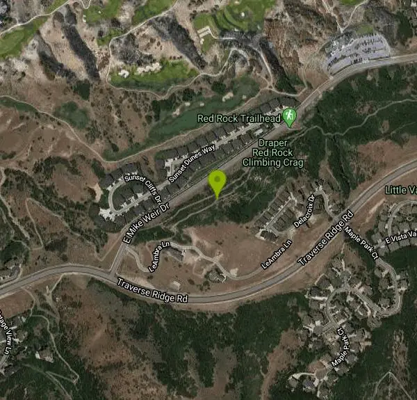
The Red Rock trail located in Draper, Utah is a short loop trail just down the road from the Draper LDS Temple. The hike itself may be short, but since it is along the cliffs of the southern end of the Salt Lake Valley, there are beautiful views to enjoy seemingly from every angle. Hiking isn't the only thing to do on the trail, rock climbing is the highlight of the trail with climbing areas being very heavy all the way through.
Most of the climbing areas are great for beginners, they don't go extremely high and have lots of hand holds. There are five main climbing walls called Facial Fracture (5.7), Dry Socket (5.8), Face Plant (5.9+), Bloody Impaction (5.10a), and Bad Case of Gingivitis (5.10a). As you can see, most of the climbing areas have a dental reference in their name. Rumor has it, the person who organized the climbing trail was a dentist and made his mark on the climbing area that way. The most challenging of the climbs are Bad Case of Gingivitis, Bloody Impaction and Face Plant so if you are a beginner, or are climbing with a beginner then Facial Fracture and Dry Socket may be the best place to start.
The loop is only about a mile long but has a lot to offer in terms of recreation and beauty. It is usually utilized most during the summer months from May to September when trail and climbing conditions are best. Red Rock trail has a little something for the adventurer in all of us and can also be a great place to spend time with family and friends.
More Information
Never modify trail features. Ride trails when they're dry enough that you won't leave ruts. Speak up when you see others on the trail and always yield to hikers, horses, and others coming uphill. Always ride on the established trail.
Read MoreBe courteous, informed, and prepared. Read trailhead guidelines, stay on the trail, and don't feed the wildlife.
Read More- Plan Ahead and Prepare
- Travel & camp on durable surfaces
- Dispose of waste properly
- Leave what you find
- Minimize campfire impacts
- Respect wildlife
- Be considerate of other visitors
Directions
From Draper, Utah
- Head north on S 970 E toward E 12400 S/
Pioneer Rd (335 ft) - Turn right onto E 12400 S/
Pioneer Rd Continue to follow Pioneer Rd(0.5 mi) - At the traffic circle, take the 1st exit onto 1300 E (1.5 mi)
- Turn right onto Highland Dr (0.2 mi)
- Turn left onto S Rambling Rd (0.8 mi)
- At the traffic circle, take the 1st exit onto E Mike Weir DrDestination will be on the left(1.3 mi)
Look for the gravel parking lot on the east side of Mike Weir Drive, just south of the South Mountain Golf Course. This is where you’ll park. From the parking lot, follow the trail taking you to the Bonneville Shoreline Trail. Keep an eye out for the sign that says Red Rock and take a left up to the crag. It’s about a five-minute approach.Courtesy of rootsrated.com


Trails
Distance ?
0.8 milesReal Ascent ?
174 feetReal Descent ?
149 feetGrade (-17° to 25°)
-30% to 46%Elevation differences are scaled for emphasis. While the numbers are accurate, the cut-away shown here is not to scale.
Other Rock Climbing Walls, Mountain Bike Trails, and Hiking Trails Nearby

Little Valley Trail
Draper, Utah
0.4 miles EOne of the best places in the Salt Lake valley to take kids mountain biking is the Little Valley Instructional Trails. Fortunately, these superbly constructed “flow” trails are just as...
Hike, Mountain Bike 0.6 mi
Potato Hill Trail
Draper, Utah
0.5 miles ELocated in Draper, UT, Potato Hill Trail start at the trailhead on Transverse Mountain Road. and goes down to the (BST) or Bonneville Shoreline Trail west of Coyote Hollow. There are some trails that...
Hike, Mountain Bike 1.6 mi
Corner Canyon Trail
Draper, Utah
1.4 miles NECorner Canyon is the "Go To" riding area in South Salt Lake and for many riders it is worth the drive (or ride) from Utah County. It is a good mix of everything from beginner training...
Backpack, Hike, Mountain Bike 0.6 mi
Bst To Equestrian Center Loop
Draper, Utah
1.4 miles NEAn intermediate trail with a length of 10 miles that's located in Draper, UT. It's a single track look trail that has an elevation of 417 ft. Start at the Equestrian Center and follow the...
Hike, Mountain Bike 1.3 mi
Eagle Crest Trail
Draper, Utah
1.5 miles SEEagle Crest trail is a beginner level trail mountain bike in Draper, Utah along the north side of Traverse Mountain. From the trail, riders can see the Salt Lake Valley, the Northern end of Utah...
Hike, Mountain Bike
Mercer Hollow Trail
Draper, Utah
1.9 miles EMercer Hollow Trail is primarily used to bomb down the southern flanks of the ridge the Corner Canyon Trails sit on. It's filled with berms, rock features, rollers, and sweet, sweet...
Hike, Mountain Bike 1.2 mi
Ghost Falls Trail
Sandy, Utah
2.2 miles EGhost Falls is located in the corner canyon riding area of Draper, Utah and one of the first mountain bike routes in the canyon. It's a family-friendly hike, named for the...
Hike, Mountain Bike, Snowshoe 0.2-1.8 mi
Lone Peak
Draper, Utah
2.2 miles EEstablished in 1978 and located southeast of Salt Lake, Lone Peak is one of the taller peaks in the Wasatch range along the Wasatch Front. It has 5 main trailheads: Jacobs Ladder via Corner Canyon...
Hike, Mountain Bike, Rock Climb 1.7 mi
Jacob's Ladder Trail
Sandy, Utah
2.3 miles EJacobs Ladder trail has an elevation trail of 5,700 ft. and the most popular trailhead out of the five trails in Lone Peak. It's located near a large area on the right side of the road...
Hike, Mountain Bike 0.5 mi
Draper City Park
Draper, Utah
2.6 miles NDraper City Park is located in the center of the Draper Town Center and the park is near the Porter Rockwell Trail and Willow Creek Trail so visitors can walk or jog around. There are trail heads for...
Hike 0.8 mi
Bear Canyon Suspension Bridge
Draper, Utah
2.7 miles NEThe Bear Canyon Suspension Bridge is a 185ft bridge that connects the Bear Canyon to the Bonneville Shoreline Trail. The bridge was built and completed in 2015 thanks to donations from residents and...
Hike, Mountain Bike 0.2 mi
Orson Smith trail
Draper, Utah
3.1 miles NEOrson Smith Trail is located north of the Corner Canyon Gate. It leads up to the suspension bridge and has become a popular spot for hiking and bike routes since the suspension...
Hike, Mountain Bike 0.4 mi
Hidden Valley Park trail
Sandy, Utah
4.4 miles NEHidden Valley Trail has different levels and gradual uphill fun and makes for a good adventure trail. It's a wide, shallow valley that is hidden from view; hence the name. The valley’s...
Hike, Mountain Bike 0.2 mi
Rocky Mouth Trail/Waterfalls
Sandy, Utah
5.0 miles NEThis adventure begins with a very scenic hike to a beautiful waterfall and ends with a magnificent rappel through a short slot canyon and down the waterfall. The hike to the waterfall is a great trip...
Canyoneer, Hike, Rock Climb 1.7 mi
Schoolhouse Springs Trail
Alpine, Utah
5.2 miles ESchoolhouse Springs trail has an elevation trail at 5,300 ft. It's located at the end of the town of Alpine. It features a lake and there's a number of activities including horse-back...
Hike, Mountain Bike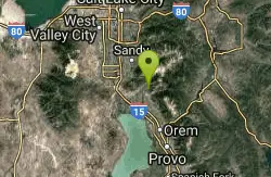
Rodeo Down
Alpine, Utah
5.8 miles EBlack Dog. Trail winds from the middle of Corkscrew down to Flank and River, just south of the water tank. Some technical aspects, length 0.5 miles with 300 vertical feet elevation...
Mountain Bike 1.1-4.7 mi
Bells Canyon
Sandy, Utah
6.1 miles NEBells Canyon is a moderate, 4.5 mile hike that begins in a residential area and ends at a waterfall in the enter of the canyon's forest. The first 1/2 mile of the hike is relatively...
Backpack, Hike, Mountain Bike, Snowshoe
Scruffy Band Little Cottonwood Canyon
Sandy, Utah
7.4 miles NERock Climb near Sandy, Utah
Rock Climb 3.2 mi
Little Cottonwood Pipeline Trail
Sandy, Utah
7.4 miles NELocated in Sandy, UT, Little Cottonwood Pipeline trail starts at the mouth of Little Cottonwood Canyon and is a single-track trail with some rocky situations on the trail. The first portion of the...
Mountain Bike 0.7 mi
Great White Icicle
Sandy, Utah
8.4 miles NEThe Great White Icicle is located in Little Cottonwood Canyon just outside of Salt Lake City, Utah. It is a climbing area that is a frozen waterfall in the winter and a cascading waterfall...
Hike, Rock ClimbNearby Campsites

Mount Timpanogas
Provo, Utah
12.1 miles EMt. Timp, as the locals call it, is the 2nd highest mountain in the Wasatch range (only Mt. Nebo is higher). What sets "Timp" apart is its location. It towers over the Provo, Orem, Pleasant...
Camp, Hike, Horseback, Swim
Spruces Campground
Salt Lake City, Utah
15.7 miles NECamping isn't free. See USDA.gov for details. If you know the coordinates of the sledding hill here, please comment.
Camp, Sled
Mill Creek Canyon
Salt Lake City, Utah
16.6 miles NEMill Creek is an out and back with over 1000 ft of elevation gain. The lower section of the ski trail gets a lot of foot traffic, but the upper section (above Elbow Fork) is generally very quiet....
Camp, Cross-country Ski, Snowshoe
Y-Mountain Summit Trail
Provo, Utah
21.3 miles SEY Mountain is located directly east of Brigham Young University (BYU) in Provo, Utah, United States. The Slide Canyon/Y Mountain Trail leads to a large block Y located 1.2 miles (1.9 km) from a...
Camp, Hike
Holbrook Trailhead
Bountiful, Utah
27.3 miles Nairsoft feaild woth bunkers
Airsoft, Backpack, Camp, Paintball, Snowshoe 4.7 mi
Fifth Water Hot Springs
Provo, Utah
38.5 miles SEAKA Diamond Fork Hot Springs A beautiful drive and a 2.5 mile hike along the river will end you at an amazing set of hot springs that's well worth the trip. There's a variety of...
Backpack, Camp, Hike, Hot Springs, Mountain Bike, Swim 5.6 mi
Antelope Island Lakeside Trail
Syracuse, Utah
42.3 miles NWThe Lakeside Trail is a kid-friendly trail with great views and many bugs. This is a gorgeous scenic hike winding around part of the Great Salt Lake. The trail on Antelope Island that runs about...
Camp, Hike, Horseback
Antelope Island State Park
Syracuse, Utah
42.4 miles NWLocated just 41 miles north of Salt Lake City, Antelope Island State Park encompasses a vast selection of outdoor activities and spectacular scenery providing a peaceful nature experience. Experience...
Backpack, Camp, Hike, Horseback, Mountain Bike


