


Y-Mountain Summit Trail
Provo, Utah

| Address: | ~Y-Mountain Summit Trail, Uinta-Wasatch-Cache National Forest, Provo, UT 84604, USA |
| GPS: |
40°14'45.0"N 111°36'28.2"W Maps | Directions |
| State: | Utah |
Camp and Hike
Y Mountain is located directly east of Brigham Young University (BYU) in Provo, Utah, United States. The Slide Canyon/Y Mountain Trail leads to a large block Y located 1.2 miles (1.9 km) from a parking area at the mountain's base. This hillside letter was built over a hundred years ago as the insignia for BYU. For years the trail to the Y has been one of the most hiked trails in Utah Valley and provides a beautiful view of Provo and Orem, the rest of the many cities in Utah Valley and Utah Lake. The trail is also regularly used by hikers, bikers, paragliders and hunters to access the backcountry in the Slide Canyon area.
The large white Y on the side of the mountain has become the nationally recognized insignia for BYU and the reason why BYU is often called "the Y". It is made of concrete and is 380 feet high and 130 feet wide (116 by 40 m). The Y is even larger than the "Hollywood Sign" in Los Angeles.
There are 14 strands of lights placed around the perimeter of the Y, which are lit five times a year by the Intercollegiate Knights. It is lit for Freshman Orientation, Homecoming, Y Days, and graduation in April and August.
More Information
Add ResourceBe courteous, informed, and prepared. Read trailhead guidelines, stay on the trail, and don't feed the wildlife.
Read More- Plan Ahead and Prepare
- Travel & camp on durable surfaces
- Dispose of waste properly
- Leave what you find
- Minimize campfire impacts
- Respect wildlife
- Be considerate of other visitors
Directions
From Provo, Utah
- Head west on Center St toward N University Ave (46 ft)
- Turn right at the 1st cross street onto N University Ave (0.6 mi)
- Turn right onto E 700 N (0.8 mi)
- Turn left onto 900 E (0.1 mi)
- Turn right at the 1st cross street onto E 820 N (0.6 mi)
- E 820 N turns slightly left and becomes Oakmont Ln (0.2 mi)
- Turn right onto Oak Cliff Dr (0.2 mi)
- Turn right onto Terrace Dr (486 ft)
- Turn left (0.2 mi)
- Slight left (135 ft)
jamadeus
4/24/17 10:31 amsloftin
4/12/15 5:31 pm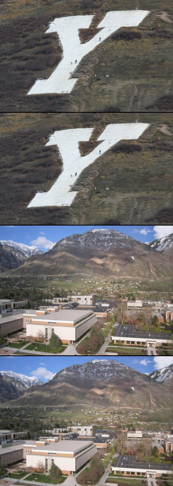


Other Hiking Trails Nearby

Bicentennial Park
Provo, Utah
2.5 miles SWA 16-hole disc golf course in Provo beside a duck pond, a playground, a boardwalk nature trail with natural springs, and mature trees that make even moderate holes a genuine challenge.
Disc Golf, Hike, Sled
Provo River Parkway Trail
Provo, Utah
7.8 miles NA fully paved 6-mile canyon ride from Vivian Park to the mouth of Provo Canyon, passing waterfalls and a fish-feeding spot — best done with two cars for a car-shuttle downhill.
Hike, Mountain Bike 1.2 mi
Battle Creek Falls
Pleasant Grove, Utah
9.5 miles NWA short 1.2-mile family-friendly hike in Pleasant Grove to a scenic waterfall with views from below and above, plus a nearby rappelling and rock climbing area just beyond the falls.
Canyoneer, Hike
G Mountain Trail
Pleasant Grove, Utah
9.5 miles NWA family-friendly 1.5-mile roundtrip hike from Kiwanis Park to a hillside 'G' landmark near Pleasant Grove — a little steep at the start and the end, but great for all ages.
Hike
Grove Creek Trail
Pleasant Grove, Utah
10.4 miles NWA steep, shuttled downhill singletrack dropping from the shoulder of Mount Timpanogos through Grove Creek Canyon — the climb is brutal, but the descent is worth it.
Hike, Mountain Bike
Stewart Falls
Provo, Utah
10.9 miles NA glacier-fed, 200-foot multi-tiered waterfall on Mt. Timpanogos — about a 4-mile round trip hike through forest with a few steep edges near the falls.
Hike
Timpanogos Falls
Provo, Utah
11.0 miles NA lesser-known multi-tiered waterfall on the Mt. Timpanogos trail, visible early on and surrounded by wildflowers in late spring — a great beginner hike shared with the Stewart Falls trailhead.
Hike
Dripping Rock
Spanish Fork, Utah
11.2 miles SDripping Rock is along a paved path adjacent to Spanish Oaks Golf Course.
Hike 1.6-14.1 mi
Mount Timpanogas
Provo, Utah
12.9 miles NUtah's most-climbed mountain towers 7,000 feet above the Provo valley, stretching seven miles north to south with multiple peaks over 11,000 feet — a Wasatch landmark.
Camp, Hike, Horseback, Swim 1.5 mi
Timpanogas Cave
Provo, Utah
14.6 miles NColorful cave formations — cave bacons, columns, flowstone, and drapery — inside a Timpanogos mountain cave, reached by a 1.5-mile paved trail; tours run May through September.
Backpack, Cave, Hike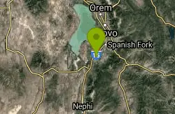
P Mountain and Little Mountain
Payson, Utah
15.4 miles SWP Mountain and Little Mountain is Payson's hometown hike, a short, rewarding ridge walk in the Uinta-Wasatch-Cache National Forest that leads to the point above the giant white "P" overlooking town,...
Hike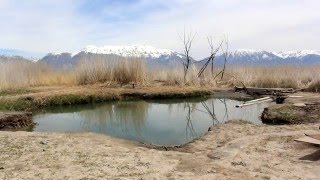
Saratoga Hot Springs
Saratoga Springs, Utah
17.1 miles NWThree naturally heated pools around 100°F year-round, a muddy beautiful setting, and an easy walk to nearby Utah Lake for wildlife watching between soaks.
Hike, Hot Springs 4.7 mi
Fifth Water Hot Springs
Provo, Utah
17.4 miles SEA scenic 2.5-mile riverside hike to the famous Diamond Fork rock pools and waterfall, with soaks up to 108°.
Backpack, Camp, Hike, Hot Springs, Mountain Bike, Swim 1.7 mi
Schoolhouse Springs Trail
Alpine, Utah
18.2 miles NWA short, scenic trail at 5,300 feet in Alpine, Utah, featuring a lake and activities from horseback riding to hiking — best enjoyed between May and October.
Hike, Mountain Bike
Mercer Hollow Trail
Draper, Utah
19.7 miles NWA fast, flowy descent on the southern flank of Corner Canyon Ridge, packed with berms, rock features, rollers, and a quick uphill that rewards you on the way back down.
Hike, Mountain Bike 1.3 mi
Eagle Crest Trail
Draper, Utah
19.7 miles NWA beginner-level 2.4-mile mountain bike trail along the north side of Traverse Mountain in Draper, with sweeping views of Salt Lake Valley, Mount Timpanogos, Lone Peak, and Box Elder Mountain.
Hike, Mountain Bike 0.3 mi
Kiowa Valley Path
Eagle Mountain, Utah
20.0 miles WA 0.3-mile paved path affectionately dubbed 'Lizard Hill' by local kids — easy on any stroller, gentle enough for all ages, and filled with basking lizards and rabbits along the way.
Hike 1.7 mi
Jacob's Ladder Trail
Sandy, Utah
20.4 miles NWJacob's Ladder is the steep, relentless local favorite for climbing into the Lone Peak Wilderness above Draper, Utah — and a legendary technical descent.
Hike, Mountain Bike 0.2-1.8 mi
Lone Peak
Draper, Utah
20.4 miles NWOne of the Wasatch Front's taller peaks at over 11,000 feet, Lone Peak offers five different trailhead approaches, a 9-mile average round trip, rugged canyon terrain, and stunning Salt Lake valley views.
Hike, Mountain Bike, Rock Climb 1.2 mi
Ghost Falls Trail
Sandy, Utah
20.4 miles NWA family-friendly hike in Corner Canyon that winds through sandy rocky slopes and dry creek beds to the Ghost Falls loop, with helpful trail signs at the confusing intersections.
Hike, Mountain Bike, SnowshoeNearby Campsites
Mount Timpanogas
Provo, Utah
12.9 miles NUtah's most-climbed mountain towers 7,000 feet above the Provo valley, stretching seven miles north to south with multiple peaks over 11,000 feet — a Wasatch landmark.
Camp, Hike, Horseback, Swim 4.7 mi
Fifth Water Hot Springs
Provo, Utah
17.4 miles SEA scenic 2.5-mile riverside hike to the famous Diamond Fork rock pools and waterfall, with soaks up to 108°.
Backpack, Camp, Hike, Hot Springs, Mountain Bike, Swim
Spruces Campground
Salt Lake City, Utah
27.4 miles NA fee campground in Big Cottonwood Canyon near Salt Lake City — check USDA.gov for current rates and seasonal availability.
Camp, Sled
Mill Creek Canyon
Salt Lake City, Utah
31.9 miles NAn out-and-back canyon trail with over 1,000 feet of elevation gain — the lower ski trail sees heavy traffic while the upper section above Elbow Fork stays quiet, with a reservable Yurt at the top December through April.
Camp, Cross-country Ski, Snowshoe
Holbrook Trailhead
Bountiful, Utah
45.6 miles NThe Holbrook Trailhead is a popular access point for the Bonneville Shoreline Trail and Holbrook Canyon above Bountiful, Utah, on the western face of the Wasatch. Perched on the bench right at the...
Airsoft, Backpack, Camp, Paintball, Snowshoe
Maple Canyon
Fountain Green, Utah
47.9 miles SMaple Canyon's one-of-a-kind cobblestone conglomerate cliffs host 140+ bolted routes from 5.4 to 5.14, making it one of the most unique climbing destinations in the US.
Camp, Hike, Mountain Bike, Rock Climb


