


225 Things to do near North/South Rainey Creek Trails
first prev 3 4 5 6 7 8 9 10 11 12 next lastShowing results within 50 miles Distance miles of Rainey Creek Rd, Irwin, ID 83428, USA City, Zip, or Address

Conant Creek Pegram Truss Railroad Bridge
Ashton, Idaho
38.8 miles NAs part of the Rails to Trails project, this old railroad bridge has been transformed into a very safe little viewing experience for the whole family. You can drive right up to the bridge where there...
Hike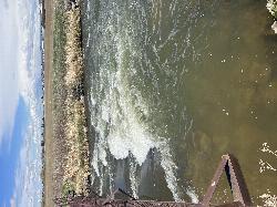
Double Tap wave feature
Idaho Falls, Idaho
39.3 miles WIt's a fun little double feature in an irrigation canal the first is a open elevation control dam that throws a nice wave and foam pile off of it great for freestyle kayaking then about 30 yards...
Canoe, Kayak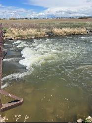
The Junk Field Wave
Idaho Falls, Idaho
39.3 miles WKayak near Idaho Falls, Idaho
Kayak
Idaho Falls Skate Park
Idaho Falls, Idaho
39.9 miles WSkateboard near Idaho Falls, Idaho
Skateboard
Fall River Bridge
Ashton, Idaho
40.0 miles NRight off Highway 20, there's a great spot to swim, swing, and dive. There's pullouts for parking right next to the bridge. There's a rope swing under the railroad bridge and a little...
Dive, Swim 1.0-7.5 mi
Idaho Falls Greenbelt
Idaho Falls, Idaho
40.1 miles WThe Idaho Falls Greenbelt is one of Idaho Falls charms located in the heart of Idaho Falls, next to the historic Idaho Falls downtown. The paved foot-trail is approximately 6 miles around,...
Hike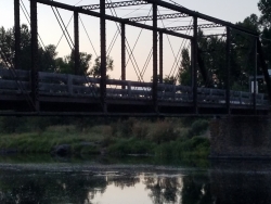
Fun Farm Bridge
Saint Anthony, Idaho
40.1 miles NWAlso known as the Funny Farm Bridge, this is an excellent place for bridge jumping. You can jump from the road level, the top of the bridge, or swing from the bars below. Just be watchful of cars...
Dive, Swim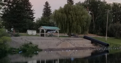
St. Anthony Sandbar
Saint Anthony, Idaho
40.4 miles NWCLOSED. //// Sand Bar Update //// ***As of 27 June 2019 *** The Sand Bar is still closed to ALL swimming, please do not cross the boundary line. We are closely monitoring the river flows...
Dive, SwimHenry's Fork Green Way (St. Anthony Green Belt)
Saint Anthony, Idaho
40.5 miles NWThis is a great walk along the river. While it is nestled right next to the highway, the closeness and beauty of the river flowing on the other side of the trail more than make up for it. Halfway...
Hike
Freeman Park
Idaho Falls, Idaho
40.7 miles WA couple of creek crossings add to appeal. Snake river borders most of this beautifully maintained course. Good elevation and variety. Public (No Fee)
Disc Golf
Beaver Dick Park
Rexburg, Idaho
41.1 miles NWBeaver Dick is a park 4.5 miles west of Rexburg, Idaho on Hwy 33. It's a 9.5 acre park that passes next to the west bank of the Henry Fork of the Snake River; it's a popular...
Camp, Canoe, Disc Golf, Swim
Twin Bridges
St. Anthony, Idaho
41.1 miles NWThere's an old abandoned bridge next to the one currently in use. The water is pretty deep underneath and offers two distinct levels to jump from. There's a little rope swing under the bridge...
Dive, Swim
Falls River, Lower Run
Ashton, Idaho
41.1 miles NFall River rises on the Madison and Pitchstone plateaus in the southwest corner of Yellowstone National Park, Wyoming and flows approximately 64 miles (103 km) to its confluence with the Henrys Fork...
Whitewater
Blackfoot River Crossing at Trail Creek Road
Firth, Idaho
41.2 miles SWIn Soda Springs, ID 34 N for ~11 mi; R (E) on Blackfoot River Rd at mp 69.9; zero odometer; travel 10.4 mi; stay to the L as rd turns to gravel at mi 10.9; mi 13.7 pass Mill Canyon Campground; mi...
Camp 0.8-1.3 mi
Warm Slough Campground
Rexburg, Idaho
41.6 miles NWThis is a pretty popular campsite that fills up pretty quick on busy weekends. Campsites are fairly spread out and there is no official donation box (as of July 2015). A couple of the campsites...
Airsoft, Camp, Canoe
Ryder Park
Idaho Falls, Idaho
41.6 miles WThe bike park Ryder Park is being actively built right now. Plans are to have several trails of varying difficulty.
Mountain Bike
Crystal Creek Campground
Jackson, Wyoming
41.7 miles ECrystal Creek Campground is located along the Gros Ventre River and Crystal Creek, both designated Wild and Scenic Rivers for the spectacular surrounding scenery and excellent fishing opportunities....
Camp

Porcupine Creek
Ashton, Idaho
42.5 miles NPorcupine Creek is a hunting, fishing, camping, and swimming spot near Ashton, Idaho in Fremont County within Targhee National Forest. It's surrounded by forests, meadows, and a creek...
Camp, Swim
Sheep Falls on Fall River
Ashton, Idaho
42.7 miles NThe lesser known Sheep Falls on Fall River is a local treasure off of Cave Falls road. There are primitive campsites and beautiful views for a great picnic spot. The water splits and comes down in...
Camp 29.6 mi
Ashton to Tetonia Trail
Ashton, Idaho
42.8 miles NThe Idaho Department of Parks and Recreation undertook the project to transform the old Teton Valley Branch of the Union Pacific Railroad from Ashton to Tetonia into a trail for bikes, ATVs, and...
Mountain Bike


