


233 Things to do near Sunrise
first prev 1 2 3 4 5 6 7 8 9 10 next lastShowing results within 50 miles Distance miles of Lost Dog Wash Trailhead, Scottsdale, AZ 85255, USA City, Zip, or Address

Perl Charles Memorial Trail (#1A)
Phoenix, Arizona
13.8 miles WThis is a technical singletrack loop with some very steep up and down sections located in the Phoenix Mountain Preserves. This trail is for advanced riders who like to bleed and leave their skin on...
Hike, Horseback, Mountain Bike
East Maricopa Floodway
Mesa, Arizona
13.8 miles SWith a primary entrance located at the intersection between Main Street and Higley Road, the East Maricopa Floodway provides riding to cyclists and mountain bikers. The surface of the floodway...
Mountain Bike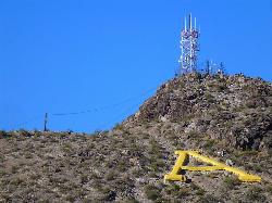
'A' Mountain at Hayden Butte
Tempe, Arizona
14.0 miles SW'A' Mountain aka Hayden Butte, is a popular hike in downtown in Tempe, Arizona. This hike located partially on Arizona State University's campus, is a short, easy walk, though it's...
Hike
Hayden Butte And Tempe Town Lake Trail
Tempe, Arizona
14.0 miles SWHike near Tempe, Arizona
Hike
Los Olivos
Phoenix, Arizona
14.0 miles SWFlat, grassy neighborhood park (used to be an olive orchard). Lots of trees. Busy on weekends. Easy to navigate. Public (No Fee)
Disc Golf
Scarlett Canyon
Phoenix, Arizona
14.0 miles WScarlett Canyon trail (not officially named) is an unmarked trail adjacent to the Scarlett Canyon residential neighborhood. This is a 3 mile loop trail considered to be easy to...
Hike, Horseback, Mountain Bike, Rock Climb
Buffalo Ridge Park
Phoenix, Arizona
14.1 miles WOffering elevation, rugged terrain, blind holes and great views. Begins near the restrooms, then a long 27 alongside the mountain back to the parking lot. Bring plenty of water. * Nov 2011. New holes...
Disc Golf

Red Mountain - North
Mesa, Arizona
14.1 miles SEThe North course is the more challenging of the two courses on site. It begins in the desert and works it way back into the park. Bring lots of water and be prepared for desert plant life, as well as...
Disc Golf
Red Mountain - South
Mesa, Arizona
14.1 miles SEEntirely in desert, this is the easier of the two courses on site. Bring water and be prepared for the desert terrain. There are plenty of big trees to challenge as well. Note: rattlesnakes have been...
Disc Golf
Buckhorn Campground Nature Trail
Apache Junction, Arizona
14.1 miles SECamp and Hike near Apache Junction, Arizona
Camp, Hike
Pebble Beach
Mesa, Arizona
14.1 miles EPebble Beach is a popular place to go tubing and swimming with designated picnic areas. It's located along the Salt River in Cibola National Forest. The reason the Salt River is so salty is...
Swim
North Mountain National Trail
Phoenix, Arizona
14.6 miles WNorth Mountain National Trail is a 2.3 mile moderate, loop trail near Phoenix. It's easy to travel on if you go up the paved sections. The inclines are steep in parts, making it a real...
Hike
Emerald Park
Mesa, Arizona
14.6 miles SMost holes feature open grassy fairways with limited trees. Pond in play on couple of holes. Alt. pin locations. Play backwards for 18 (bring the map). Practice basket south of the basketball court....
Disc Golf
Shaw Butte and Charles M Christiansen Loop Trail
Phoenix, Arizona
14.6 miles WWhen you say "North Mountain," I think most Arizonans know where it is or can find it. When you say "Shaw Butte," it seems like you get a lot more questioning glances and "huh?". Shaw...
Hike, Mountain Bike
Usery Mountain Regional Park
Mesa, Arizona
14.7 miles SEThere are many miles of two-way single-track trails in the park at several levels of difficulty. The Pass Mountain Trail should challenge intermediate to advanced riders. The Cat Peaks...
Mountain Bike 1.5 mi
Moon Rock Loop
Apache Junction, Arizona
14.8 miles SELocated within the larger Usery Mountain Regional Park, the Moon Rock loop is a fast and smooth trail that adds 1.3 miles to the more famous Blevins Trail. Although the Moon Rock loop is not known as...
Hike, Horseback, Mountain Bike
Murphy Bridle Path Trail
Phoenix, Arizona
14.8 miles WHorseback near Phoenix, Arizona
Horseback 1.7 mi
Levee Trail
Mesa, Arizona
14.9 miles SELocated within the Usery Mountain Regional Park, the Levee trail is named so because it mostly follows the top of levee, running parallel to a large section of the channel trail and a Phoenix...
Hike, Horseback, Mountain Bike
Cat Peaks - Blevin - Moonrock
Apache Junction, Arizona
15.0 miles SEFollow Blevins trail 0.6 miles, the entrance to the Moonrock loop will be on your right, marked by a brown sign and arrow. Take this loop (around 1.4 miles) until it returns to Blevin's...
Mountain Bike
Crismon Wash Trail
Mesa, Arizona
15.3 miles SEThe Crismon Wash Trail is 1.8 mile trail that is accessible from the south at the Crismon road trailhead. It is also accessible from the Blevins train to the north. There are several...
Hike, Horseback, Mountain Bike


