


212 Things to do near Ririe, ID
first prev 1 2 3 4 5 6 7 8 9 10 next lastShowing results within 50 miles Distance miles of Ririe, ID, USA City, Zip, or Address
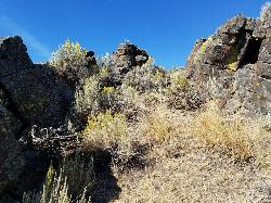
Lava Hill
Menan, Idaho
19.2 miles NWThis is a great little spot. Each team starts at one side of the collapsed lava tube. You can see each other really well from that point. Then you take the hill and get the other guys off it. It...
Airsoft, Paintball
South Fork Snake River Trail
Ririe, Idaho
19.7 miles EGo left at the trail head. It heads down about a mile and a half on double track. Then you'll come to a creek crossing. After the crossing the trail heads across a gate. Head left...
Mountain Bike
Gem Lake Bike Park
Idaho Falls, Idaho
20.1 miles SWBuilt on an old quarry, Gem Lake Bike Park offers a variety of riding. There's no shortages of berms here and there's plenty of space to get some speed, drop in or climb out. The trails here...
Mountain Bike 2.1-2.3 mi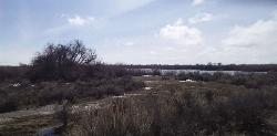
Market Lake Wildlife Management Area
Roberts, Idaho
20.8 miles NWMallards, Canada geese, canvasbacks, cinnamon and green-winged teal, northern shovelers and ruddy ducks are common waterfowl species nesting and raising broods on the WMA. Several thousand...
Hike, Horseback

Wright Creek Trail
Tetonia, Idaho
22.2 miles NEOpen to MTB, horseback riding, snowshoeing, and hiking. source: fs.usda.gov
Mountain Bike
Monkey Rock
Saint Anthony, Idaho
22.3 miles NCLOSED. PSA: Monkey Rock is no longer open to the public. The owner has posted "No Trespassing" signs and is asking the Fremont County Sheriff's Office to assist with keeping people out of their...
Swim
Hog Hollow Bridge
Saint Anthony, Idaho
22.5 miles NLess than 1/2 a mile down the road from the Monkey Rock waterfall, Hog Hollow Bridge is a favorite spot for adrenaline junkies to cool off. The place to jump is off the East side of the bridge where...
Dive, Swim
Echo Canyon aka Fall Creek
Ririe, Idaho
23.1 miles SETrail goes to the top of Deadhorse Ridge for some amazing views. Double-track, single-track, and gravel road. Length: 15 miles
Mountain BikeHenry's Fork Green Way (St. Anthony Green Belt)
Saint Anthony, Idaho
23.2 miles NThis is a great walk along the river. While it is nestled right next to the highway, the closeness and beauty of the river flowing on the other side of the trail more than make up for it. Halfway...
Hike
South Fork Fall Creek Trail
Swan Valley, Idaho
23.2 miles SEOHV trail.
Mountain Bike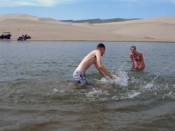
Egin Lakes
Saint Anthony, Idaho
23.4 miles NEgin Lakes is one of the favorite gateways to the St. Anthony Sand Dunes. The lakes themselves are unusually shallow and where you'll actually find a lake depends greatly on what time of the...
Sled, Swim
Echo/Indian Creek Trail
Swan Valley, Idaho
23.5 miles SEOHV trail. source: fs.usda.gov
Mountain Bike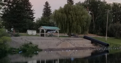
St. Anthony Sandbar
Saint Anthony, Idaho
23.5 miles NCLOSED. //// Sand Bar Update //// ***As of 27 June 2019 *** The Sand Bar is still closed to ALL swimming, please do not cross the boundary line. We are closely monitoring the river flows...
Dive, Swim 0.6 mi
Packsaddle Lake
Tetonia, Idaho
23.8 miles NEPacksaddle is one of the less well known lakes/trails in the area. If you've got a good offroad vehicle, you can probably make it all the way to the end of the road, otherwise, it's just an...
Dive, Hike, Mountain Bike, Snowshoe, Swim
Sealander Park
Idaho Falls, Idaho
23.8 miles SWThe story of Sealander park begins with Carl Sealander. Leaving Sweden in 1893 at the age of seventeen, Carl worked in mining communities across Colorado and Utah before meeting his wife, Lizzie...
Camp
Fall Creek Falls
Swan Valley, Idaho
23.9 miles SEFalls Campground is located next to the Snake River near beautiful Swan Valley, only 45 miles east of Idaho Falls, Idaho. Mixed growth cottonwood trees provide partial shade, and grassy meadows with...
Camp, Cave, Hike, Kayak, Swim
North Mahogany Trail #220
Tetonia, Idaho
24.2 miles Ehe N. Mahogany Trail is open to Motorbikes, Mountain bikes, Horses, and Hikers. Motorbikes and Horseback riders are the most common visitors, but the trail is becoming increasingly...
Mountain Bike
West Pine Creek Trail
Ririe, Idaho
24.3 miles ENon-motorized use. source: fs.usda.gov
Mountain Bike
Trail Canyon Trail
Ririe, Idaho
24.3 miles EThe Trail Canyon trail begins at Trail Canyon Parklot, T8s R43e Sec28 and ends at Intersect Trail 5251,t8s R43e Sec28. source: fs.usda.gov
Mountain Bike
Probation And Burg Bumper
Tetonia, Idaho
24.4 miles EThe Probation part of the trail is the steepest downhill in the area. Has multiple bridges and log jumps in the short mile down. The Burg portion of the trail is uphill with some...
Mountain Bike


