


98 Things to do near Tower Junction, WY 82190
first prev 1 2 3 4 5 next lastShowing results within 50 miles Distance miles of Tower Junction, WY 82190, USA City, Zip, or Address

Garnet Hill Trail
Tower Junction, Yellowstone National Park
0.2 miles EGarnet Hill Trail is a 7.6 mile loop that follows an old, dirt stagecoach road. This trail passes through large meadows, dusty areas with sagebrush, forests and beside the Yellowstone River. This...
Hike 2.4 mi
Lost Lake Trail
Tower Junction, Yellowstone National Park
0.3 miles SWLost Lake Trail is a 2.8 mile hike that can be completed in less than two hours. This is an easy hike with very little elevation change. Hikers can enjoy forests, meadows and a view of Lost Lake...
Hike 7.3 mi
Agate Creek Trail
Tower Junction, Wyoming
0.8 miles EAgate Creek Trail is a moderately difficult trail through some of Yellowstone's most beautiful and isolated landscapes. This 7.3 mile hike starts at the Yellowstone River Picnic Area. Parking is...
Hike 0.3 mi
Yellowstone River Picnic Area Trail
Tower Junction, Yellowstone National Park
0.8 miles EThe Yellowstone River Picnic Area trail is 3.9 miles loop trail. It is called the Yellowstone Picnic Area trail because the beginning of the trail is in a picnic area.This hike features a...
Hike 16.9 mi
Specimen Ridge Trail (2K4)
Buffalo Ford, Wyoming
1.5 miles ESpecimen Ridge Trail is a challenging hike that requires navigational and technical skills to complete. This 17 mile hike is remote, and though it is marked by carins and blazes, it is often...
Hike
Tower Falls
Tower Junction, Yellowstone National Park
2.3 miles SETower Fall is a waterfall on Tower Creek in the northeastern region of Yellowstone National Park, in the U.S. state of Wyoming. Approximately 1,000 yards (910 m) upstream from the creek's...
Camp, Hike
Hellroaring Creek Trail
Yellowstone National Park
2.5 miles NIf the name didn't scare you enough, the Hellroaring creek trail begins with an arduous descent down to the the Yellowstone River Suspension Bridge.The suspension bridge is a beautiful...
Camp, Hike, Swim 4.0 mi
Specimen Ridge Day Hike and Fossil Forrest Trail
Buffalo Ford, Wyoming
4.4 miles ESpecimen Ridge Day Hike is a strenuous almost 4 mile trail to Specimen Ridge. This trail is rugged with a high elevation, and is not recommended for hikers with respiratory or heart...
Hike 8.5 mi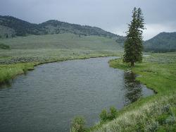
Slough Creek Trail
Tower Junction, Yellowstone National Park
5.6 miles ESlough Creek Trail is a 3.4 mile out and back trail that follows a historic wagon trail through several meadows. This trail is a fairly easy hike that has beautiful views of Slough Creek. The...
Hike
Slough Creek Campground
Tower Junction, Yellowstone National Park
5.8 miles NESlough Creek campground is a small but very popular campground on the Northeast Entrance Road. Most of the campsites are situated right on the banks of Slough Creek where fishing is a favorite...
Camp 2.8 mi

Mount Washburn Bike Trail
Devils Den, Wyoming
6.5 miles SMount Washburn Bike Trail follows Chittenden Service Road for 2.5 miles to the top of Mount Washburn. This steep climb up the mountain provides a challenging elevation gain of 1500 feet. Mount...
Mountain Bike
Forces of the Northern Range
Mammoth, Yellowstone National Park
7.9 miles WThis short 1/2 mile boardwalk located on the Blacktail Deer Plateau between Mammoth Village and Tower Junction will open your eyes and educate you about forces of nature that have sculpted the land...
Hike 4.4 mi
Chittenden Road - Mount Washburn Trail
Canyon Village, Yellowstone National Park
8.2 miles SHiking Mount Washburn via Chittenden Road is the shortest and easiest route to the top. The trail was once a service road and is now a clear well packed trail with a steady, gradual incline. The...
Hike 16.3 mi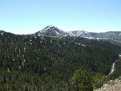
Mount Washburn Spur Trail
Canyon Village, Yellowstone National Park
8.2 miles SWashburn Spur Trail is an exciting 8-mile trail connecting the peak of Mount Washburn to Seven Mile Hole Trail near Canyon Village. Hikers typically hike the trail starting at Mount Washburn and...
Hike 7.4 mi
Blacktail Deer Creek to Yellowstone River Trail
Mammoth Hot Springs, Yellowstone National Park
9.1 miles WBlacktail Deer Creek Trail is a 7 mile out and back trail that leads to the Yellowstone River. Hikers on this trail will enjoy seeing green open fields, boulder formations and waterfalls at the...
Hike 3.4 mi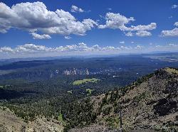
Dunraven Pass - Mount Washburn Trail
Canyon Village, Yellowstone National Park
9.2 miles SHikers looking for a scenic hike to the peak Mount Washburn will be pleased hiking the Mount Washburn Trail via Dunraven Pass. This trail winds through quiet forests to the peak. The trailhead for...
Hike 0.8 mi
Wraith Falls Trail
Mammoth Hot Springs, Yellowstone National Park
10.3 miles WWraith Falls Trail is a less than 1 mile there and back hike that can be taken in under an hour. This is a wonderful family friendly hike that is easy for hikers of all levels. The hike leads...
Hike 7.6 mi
Observation Peak Trail
Canyon Village, Yellowstone National Park
11.8 miles SObservation Peak Trail is one of the most famous hikes in Yellowstone National Park. The hike is an almost 10 miles there and back hike that starts and ends at the same trailhead. Observation...
Hike 2.4 mi
Cascade Lake Trail
Canyon Village, Yellowstone National Park
11.9 miles SCascade Lake Trail is an easy, short hike through picturesque meadows to the beautiful cascade lake. The trailhead is located North of Canyon Village on Grand Loop Road. There is a pullout here where...
Hike
Coyote Creek Trail
Gardiner, Montana
12.5 miles NWnear Gardiner, Montana


