


Refine Search
- hike 46
- swim 42
- camp 11
- mountain bike 8
- backpack 7
- canyoneer 4
- dive 4
- horseback 3
- rock climb 3
- cross-country ski 1
- hot springs 1
- kayak 1
50 locations
Add Location
 Full Listing
Show more
Camp, Hike, Swim
Added on 30 Nov 2017
Full Listing
Show more
Camp, Hike, Swim
Added on 30 Nov 2017
 Full Listing
Show more
Backpack, Camp, Hike, Swim
Added on 30 Nov 2017
Full Listing
Show more
Backpack, Camp, Hike, Swim
Added on 30 Nov 2017
 Full Listing
Show more
Backpack, Hike, Kayak, Swim
Added on 28 Nov 2017
Full Listing
Show more
Backpack, Hike, Kayak, Swim
Added on 28 Nov 2017
 Full Listing
Show more
Swim
Added on 27 Nov 2017
Full Listing
Show more
Swim
Added on 27 Nov 2017
 Full Listing
Show more
Swim
Added on 27 Nov 2017
Full Listing
Show more
Swim
Added on 27 Nov 2017
 Full Listing
Show more
Hike, Mountain Bike, Swim
Added on 27 Nov 2017
Full Listing
Show more
Hike, Mountain Bike, Swim
Added on 27 Nov 2017
 Full Listing
Show more
Camp, Hike, Swim
Added on 27 Nov 2017
Full Listing
Show more
Camp, Hike, Swim
Added on 27 Nov 2017
 Full Listing
Show more
Camp
Added on 14 Nov 2017
Full Listing
Show more
Camp
Added on 14 Nov 2017
 Full Listing
Show more
Camp, Hike, Mountain Bike
Added on 13 Nov 2017
Full Listing
Show more
Camp, Hike, Mountain Bike
Added on 13 Nov 2017
 Full Listing
Show more
Camp, Hike
Added on 13 Nov 2017
Full Listing
Show more
Camp, Hike
Added on 13 Nov 2017
Haigler Canyon Campground
Payson, Arizona
20.7 miles E of Payson, ArizonaThis campground was constructed in 2007 and offers 2 day-use sites and 2 campground areas with 14 overnight sites. This campground boasts a diversity of trees. Fishing for rainbow trout is a popular pastime here. The stream is periodically stocked with trout April through late August. The chiseled canyons offer swimming holes. Courtesy of fs.usda.gov
Hell's Gate
Payson, Arizona
12.9 miles E of Payson, ArizonaThis Wilderness was established in 1984, and contains approximately 37,440 rough acres with a major canyon and perennial stream extending its entire length. Deep pools of water may be separated by impassable falls. Elevations range from 3,000 feet along the lower end of Tonto Creek to 6,400 feet on Horse Mountain. Spring and fall are ideal times to visit this area, however trails are rare and access is limited. The tiny area known as Hellsgate is not to be used by livestock due to inaccessibility and impacts.Courtesy of fs.usda.gov
0.4 mi
 Full Listing
Show more
Camp, Hike, Swim
Added on 29 Nov 2017
Full Listing
Show more
Camp, Hike, Swim
Added on 29 Nov 2017
Clear Creek Campground
Camp Verde, Arizona
6.0 miles SE of Camp Verde, ArizonaWest Clear Creek flows along the boundary of this desert canyon country camp and is a popular place for hiking, swimming, wading and fishing. Cool water species such as smallmouth bass and green sunfish populate the stream near the campground. The oasis bordering the creek and extending into the campground is an excellent place for wildlife watching. It provides a productive home to a number of species of colorful songbirds and raptors. Beyond those lush environs, the Sonoran desert bristles with cactus and adds variety to any hike. Clear Creek Campground is grassy and flat with shade provided by tall cottonwoods. It has a relaxed and open atmosphere that keeps people coming back year after year. Just a short gravel road separates the campground from nearby paved SR 260.Courtesy of fs.usda.gov
1.0 mi
 Full Listing
Show more
Hike, Swim
Added on 28 Nov 2017
Full Listing
Show more
Hike, Swim
Added on 28 Nov 2017
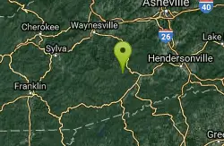
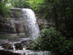
Hidden Falls
Lake Toxaway, North Carolina
3.4 miles SW of Lake Toxaway, North CarolinaHidden Falls is a serene family-friendly swimming hole in Pisgah National Forest just down river from the towering Rainbow Falls. It's on the Horsepasture River "hidden" just a few steps off the main trail. Most hikers miss it. The waterfall is less than 10 feet tall, but it drops into an idyllic pool surrounded by boulders that act as a small dam and provide sunning and picnic spots.Courtesy of romanticasheville.com
This spot is also known as "Hollow Falls."
1.3 mi
 Full Listing
Show more
Hike, Swim
Added on 28 Nov 2017
Full Listing
Show more
Hike, Swim
Added on 28 Nov 2017
Rainbow Falls
Lake Toxaway, North Carolina
3.4 miles SW of Lake Toxaway, North CarolinaRainbow Falls is one of the most spectacular waterfall settings in the Blue Ridge Mountains of North Carolina. This 150-ft. tall waterfall is impressive, especially after rainy weather that swells the Horsepasture River. The best feature of Rainbow Falls is the ability for visitors to experience the falls from the front, bottom, side and top! Located in the Pisgah National Forest, adjacent to Gorges State Park, Rainbow Falls is just one of a series of cascades and waterfalls on a two-mile stretch of the river. The park is in the Sapphire community, near Lake Toxaway, and about 55 miles from downtown Asheville. Courtesy of romanticasheville.com
Big East Fork
Canton, North Carolina
11.7 miles S of Canton, North CarolinaBig East Fork is a trail along Pigeon River with a variety of activities available. This trail travels through heavy forest along the river with beautiful, clear water. There are several waterfalls throughout this hike, and the river varies from white rapids to calm pools. The variety of water depths and speeds along Big East Fork provide perfect kayaking conditions as well as pristine swimming holes. Swimming and kayaking are both done at your own risk.
Camping is allowed in Big East Fork, with several perfect campsites available. These campsites are natural, with no amenities, so campers should carry everything they might need with them.
Big East Fork in the Pisgah National Forrest is a beautiful place to visit year round. With its opportunities to cool off in the hot summer and enjoy the stunning colorful leaves in the fall, Big East Fork makes a perfect destination any time of year.
0.1 mi
 Full Listing
Show more
Swim
Added on 27 Nov 2017
Full Listing
Show more
Swim
Added on 27 Nov 2017
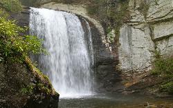
Looking Glass Falls
Brevard, North Carolina
4.7 miles NW of Brevard, North CarolinaLooking Glass Falls is one of the most popular and beautiful waterfalls in North Carolina. And it's perhaps the easiest to view (one of the few accessible roadside waterfalls, making it perfect for folks with mobility and walking challenges). The name "Looking Glass" comes from Looking Glass Rock, where water freezes on its sides in the winter and then glistens in the sunlight like a mirror or looking glass. Looking Glass Creek, which flows past the rock, is also named for the impressive natural structure. ... Its easy accessibility makes Looking Glass Falls a popular spot for travelers along U.S. 276, Forest Heritage Scenic Byway, near Brevard in the Pisgah National Forest. Enjoy nice views from the parking area along the road. Or take a short walk for a closer look. The waterfall is 60 feet tall.Courtesy of romanticasheville.com
0.8 mi
 Full Listing
Show more
Hike, Mountain Bike, Swim
Added on 27 Nov 2017
Full Listing
Show more
Hike, Mountain Bike, Swim
Added on 27 Nov 2017
Daniel Ridge Falls
Brevard, North Carolina
4.8 miles NW of Brevard, North CarolinaThis waterfall in Pisgah National Forest near Brevard has multiple names: Tom's Spring Branch Falls, Daniel Ridge Falls and Jackson Falls. It’s an easy half-mile hike on the Daniel Ridge Trail to reach the base of this 150-ft. waterfall. As with many waterfalls, it’s most impressive after some decent rain. During summer dry spells, the flow is a tiny stream. You can either hike quick one-mile direct round-trip or the entire four-mile loop that includes the top of the waterfall. Courtesy of romanticasheville.com
Cove Creek Tubs
Brevard, North Carolina
5.9 miles NW of Brevard, North CarolinaBest tubs in the Pisgah Forest. They’re three magnificent pot holes like you’d expect to find in Vermont or New Hampshire. At the top is a seven foot, almost perfectly round tub. From it a narrow curtain of water accelerates into a cascade, then pools into a perfectly dimensioned oval, eight feet long and four feet wide. Water continues another 40 linear feet and 15 vertical feet of what’d be a pretty good waterslide, except for a mature hemlock that has fallen smack across the prime portion. It’ll be there a long time unless someone cuts it out. After bumping into the hemlock, water continues 60 feet to a relaxed pool that is nice. This lower pool has a sweet spot 10 to 12 feet long. On the right is a small piece of continuous rock. It’s about the only place to lie down in this steep little drainage where all of the horizontal space is filled with water. This lower tub is also the sunniest place on the creek. Overall it rates as fair. But the tubs at the top lift Cove Creek’s overall rating to good, even though the second one is — only chin deep. It just needs more scale and volume than a watershed fewer than five square miles can produce.Courtesy of running-water.com
Whaleback Swimming Hole
Asheville, North Carolina
26.3 miles SW of Asheville, North CarolinaMost people in this neck of the woods will head straight to Sliding Rock or Looking Glass Falls, but the locals go to Whaleback on the Davidson River above the fish hatchery. A massive slab of bedrock forms a horseshoe around a deep swimming hole. A small cascade tumbles into the green pool, which is surrounded by a lush hardwood forest. The pool—20 feet wide and twice as long—marks the spot where Cove Creek meets the Davidson River. Crowds are nonexistent during the week and minimal on weekends. Courtesy of blueridgeoutdoors.com
Coontree Recreation Area
Brevard, North Carolina
4.2 miles NW of Brevard, North CarolinaCoontree Recreation Area is a beautiful area with many amenities and activities on the Davidson River. This recreation area is best known for its picnic area with a beautiful view of the river. The picnic area is equip with 10 picnic tables and restrooms with flushing toilets. From Coontree Picnic Area visitors have direct access to the river. Here the river is perfect for swimming and fishing. The water here is calm and deep, making this the perfect place for families to enjoy Davidson River.
Coontree is also a great area for hiking. Coontree Loop Trail goes through the Pisgah National Forrest for 3.7 miles. This trail is moderately difficult and provides beautiful views of the river and forest. Along the trial hikers can explore small waterfalls and swimming holes, in addition to the swimming hole available at the picnic area. The east side of the trail is open seasonally for mountain biking, from October 15 through April 15th.
Davidson River Campground
Pisgah Forest, North Carolina
2.9 miles NW of Pisgah Forest, North CarolinaDavidson River Recreation Area offers camping and outdoor activities for the whole family. The campground boasts several loops of shaded campsites, as well as access to hiking trails, fishing spots, waterfalls and several nearby attractions within Pisgah National Forest. It lies just four miles west of the town of Brevard and less than an hour from the city of Asheville. The facility is open year-round.Courtesy of recreation.gov
1.4 mi
 Full Listing
Show more
Backpack, Hike, Swim
Added on 22 Nov 2017
Full Listing
Show more
Backpack, Hike, Swim
Added on 22 Nov 2017
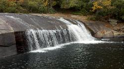
Turtleback Falls
Lake Toxaway, North Carolina
3.3 miles SW of Lake Toxaway, North CarolinaTurtleback Falls was named for its domed shape, similar to the back of a turtle. It's also called "umbrella falls" for the same reason. Visitors slide down Turtleback as the river flows over the slab of rock and drop into an open pool basin, also known as the Chug Hole. This great swimming hole is a quarter mile upstream from the 150' Rainbow Falls.
Located near Brevard on the Horsepasture River in the Pisgah National Forest, Turtleback Falls is an open slip-in-slide waterfall for the summer months. Visitors go down Turtleback falls and drop roughly 10 feet into an open pool basin.
Although Turtleback is a great swimming spot, it can also be dangerous. The water currents can be very strong and visitors have either drowned or have been swept downriver and over 125' rainbow river. If you want to slide, it's best to wait until the water currents aren't strong so it's safer to swim. If you want to find a calmer swimming hole, then go 1/3 of a mile down the river at Hidden Falls.
Turtleback falls is mostly a calm place to slip and swim and a great summer activity!
4.0 mi
 Full Listing
Show more
Camp, Hike, Swim
Added on 14 Nov 2017
Full Listing
Show more
Camp, Hike, Swim
Added on 14 Nov 2017
Woods Canyon Lake
Payson, Arizona
22.9 miles E of Payson, ArizonaWoods Canyon Lake is a fishing lake near Payson, Arizona located near the Mogollon Rim. The lake has a hike that loops around it, and several other hikes nearby to look at the particularly scenic views just off of nearby Rim Road.
Access to the lake is restricted in the winter due to snowy conditions on the road, and reopens in the spring as the snow melts.
Woods Canyon Lake is managed as a trout fishery. Some people swim in the lake but it is not recommended. Courtesy of woodscanyonlakeaz.com
1.7 mi
 Full Listing
Show more
Hike
Added on 14 Nov 2017
Full Listing
Show more
Hike
Added on 14 Nov 2017
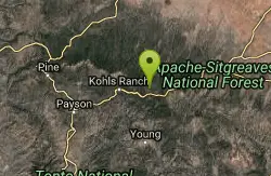
Meadow Trail #505
Payson, Arizona
22.9 miles E of Payson, ArizonaMeadow Trail #505 is a short, paved path along the rim of Woods Canyon Lake, high on Arizona's Mogollon Rim in the cool pines of the Apache-Sitgreaves National Forests. Smooth and nearly level, it's designed to be accessible to wheelchairs, strollers, and walkers, opening up the forest's beauty to visitors of every ability.
The trail runs from the edge of popular Woods Canyon Lake out to a scenic overlook at the rim of the canyon, with easy views of the water, the surrounding ponderosa forest, and the dramatic drop-off of the Rim country. It's a gentle, family-friendly stroll rather than a workout — perfect for a sunset walk, a picnic outing, or a relaxed leg-stretch while camping nearby.
Woods Canyon Lake is one of the Rim's most beloved recreation spots, with trout fishing, boating (electric motors only), a store, and several campgrounds close at hand, so the trail pairs easily with a full day on the mountain. At roughly 7,500 feet, it's a refreshing escape from the desert heat about two hours from the Phoenix area.
The season runs through the warmer months; bring water and sun protection, and remember that afternoon monsoon storms are common in mid- to late summer.
Aspen Campground
Payson, Arizona
22.7 miles E of Payson, ArizonaAspen Campground is a large, beautiful national-forest campground perched high on the Mogollon Rim in Arizona's Apache-Sitgreaves National Forest, less than half a mile from the shore of popular Woods Canyon Lake. At around 7,000 feet in a cool pine forest studded with oak and aspen, it's a beloved summer escape from the desert heat, roughly 35 miles from Payson off Highway 260 in the Rim Country of east-central Arizona.
The campground is spacious and well laid out, with about 136 sites spread across four loops that alternate between shady woods and open meadow, and the sites are nicely spaced for a bit of privacy. Its elevation makes for delightful summer weather, with pleasant days and cool nights when the low country below is baking. A marina with a full-service store — groceries, boat rentals, and firewood — sits right at the lake.
There's plenty to do: Woods Canyon Lake is a favorite for trout fishing and quiet boating (electric motors only), an easy trail meanders around the lake, and the campground's paved roads are great for a family bike ride. Wildlife is abundant, so expect to see birds, squirrels, deer, and elk — and note that deer, skunks, and even black bears visit the campground, so store food carefully.
A nightly campground fee applies (around $35 per site, plus a small charge for extra vehicles), and most sites are reservable through Recreation.gov in the busy summer season, so book ahead. Come prepared for cool mountain nights and afternoon monsoon storms. Pack out your trash, follow fire restrictions (which are common here), and enjoy one of the Rim Country's premier places to camp.
Sinkhole Campground
Payson, Arizona
25.6 miles E of Payson, ArizonaPerched atop the Mogollon Rim in the cool ponderosa pines of the Apache-Sitgreaves National Forests, Sinkhole Campground is a relaxed high-country base camp just a short stroll from the shore of Willow Springs Lake. At around 7,700 feet, it's a welcome escape from the desert heat — roughly a two-hour drive up from the Phoenix Valley — and a favorite of Arizona anglers and weekend campers.
The campground has 26 sites tucked among the pines. Sites 1 through 13 are first-come, first-served, while sites 14 through 26 can be reserved in advance through Recreation.gov, so you can plan ahead or take your chances on a walk-in.
The big draw is Willow Springs Lake, a 150-acre reservoir built in 1966 and stocked regularly with trout from spring through fall. Boats with motors up to 10 horsepower are allowed, and there's no fee for day use or to launch. Beyond fishing and paddling, there's hiking and mountain biking in the nearby non-motorized wildlife area, and the historic General Crook National Recreation Trail passes within a mile of camp.
A nightly campground fee applies (around $25 per site, plus a small charge for extra vehicles), reserved through Recreation.gov or taken first-come, first-served. The season runs through the warmer months; nights are cool at this elevation, so pack layers. Bring your own drinking water and firewood, and check current fire restrictions before you go.
Upper Tonto Creek Campground
Payson, Arizona
15.0 miles NE of Payson, ArizonaUpper Tonto Creek Campground is a beautiful place to camp at the intersection of Tonto and Horton Creeks. In addition to camping, this is a popular destination to both fish and hike. The campground is near the trail heads for Horton Spring 285 and for Derrick Trail 33, both of which intersect the Highline Trail.
Day-use fees are $8, while overnight stays are $16 per day, with an additional $8 for a sceond vehicle. You can camp here for up to 14 days, but the 9 sites available are first come, first served. There are vault toilets and drinking water available here.
1.1-3.5 mi
 Full Listing
Show more
Backpack, Camp, Hike
Added on 9 Nov 2017
Full Listing
Show more
Backpack, Camp, Hike
Added on 9 Nov 2017
Horton Springs
Payson, Arizona
15.1 miles NE of Payson, ArizonaHorton Springs is a spring on the Mogollon Rim that leads into Horton Creek. There are campsites near the springs, and several hiking trails in the area that lead to the spring itself. Between the waterfalls, the wildflowers, and the many maples, this is a beautiful destination to hike year round, or to backpack and explore.
Horton Creek Trail is a popular, easy hike that leads directly to the springs. The trailhead is located near the Upper Tonto Creek Campground, and is often frequented, especially on the weekends. At some points, the trail overlaps with the creek bed, so be prepared for your feet to get wet! You won't be able to do much swimming, but there's plenty of water to splash around, and you can still enjoy the refreshingly cold creek. The trail ends at the Highline Trail, at which point the Springs are only a few yards away. The waterfall where the spring emerges from the mountain is a unique sight. There are some dispersed campsites located near the spring, allowing for a potential overnight stay.
The other trail to reach Horton Spring is Horton Springs Trail; This trail begins north of the spring, off of Rim Road (or FR 300) and takes a short but steep 1-mile path down with no switchbacks to the spring. The Horton Spring Trail #292 is rated as "most difficult" and is recommended only to experienced hikers.
3.3 mi
 Full Listing
Show more
Hike
Added on 8 Nov 2017
Full Listing
Show more
Hike
Added on 8 Nov 2017
See Canyon Trail
Payson, Arizona
19.2 miles E of Payson, ArizonaSee Canyon Trail #184 takes the hiker on a journey through the wooded Arizona wilderness surrounding Christopher Creek, and leading up the Mogollon Rim. This trail has trailhead markers at the beginning and the end of the trail, allowing hikers to proceed from either end. The first mile of the hike starting from the south is relatively flat, making a great day-trip for kids and dogs (on leash). After 2/3rds of a mile from the southern trailhead, there is a side trail to the right that goes to See Spring, which makes a nice detour if you didn't bring enough water. If you want to continue on, take the fork to the left, which will take you alongside Christopher Creek for a while, before climbing up to the edge of the Mogollon Rim. The hike gets steadily more difficult after the first mile. Christopher Creek flows seasonally, so it may not have much more than a trickle if rain hasn't fallen recently.
It's worth noting that while the lush vegetation provides a beautiful hiking environment, this hike will lack the scenic views of the valley that other hikes down the Mogollon Rim offer. Maples, aspens, and oak trees offer a spectacular autumnal display.
Make sure to bring plenty of water beforehand, you will want it with the steep elevation changes. Keep an eye on the weather, and avoid potential flash flood conditions for your safety.
×


