


Broken Top Loop Trail
Visitors Center, Craters of the Moon National Monument
| Address: | Craters of the Moon National Monument & Preserve, Idaho, USA |
| GPS: |
43°25'39.7"N 113°32'55.1"W Maps | Directions |
| State: | Idaho |
| Trails/Routes: | 1.7 mi |
Restrooms Pet Friendly Bicycles Motorized Use
Cave and Hike
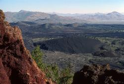
The Broken Top Loop Trail provides an opportunity to hike over, under and around the youngest volcano on the Snake River Plain. The event that created this cinder cone and associated lava flows culminated about 2,000 year ago at the end of the most recent eruptive cycle. Find out more about the outstanding lava features along the trail by following the trail guide and numbered signs.
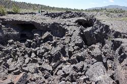
Please protect fragile lava features by staying on the designated trail and by following rock cairns across the lava. If you wish to explore Buffalo Cave, don't forget to bring a flashlight and watch your head as you enter the low ceiling of this lava tube.
The Broken Top Loop Trail is one of the most outstanding trails within Craters of the Moon. You can observe nearly every type of volcanic feature characteristic of the basaltic eruptions that created this unearthly landscape. Pick up a trail guide at the visitor center or at the trailhead sign and follow the numbered signs along the trail to learn more. This trail also provides access to Buffalo Caves (best entrance is near sign #8). Obtain a free permit at the visitor center, wear sturdy shoes and bring a flashlight before entering this or any other cave in the park.Courtesy of nps.gov
More Information
Add ResourceBe courteous, informed, and prepared. Read trailhead guidelines, stay on the trail, and don't feed the wildlife.
Read More- Plan Ahead and Prepare
- Travel & camp on durable surfaces
- Dispose of waste properly
- Leave what you find
- Minimize campfire impacts
- Respect wildlife
- Be considerate of other visitors
Directions
From Visitors Center, Craters of the Moon National Monument
- Head east on Loop RdParts of this road may be closed at certain times or days(2.8 mi)
- Turn left to stay on Loop RdMay be closed at certain times or days(0.7 mi)
- Turn right (0.3 mi)
- Keep left (0.3 mi)
- Keep rightDestination will be on the right(0.7 mi)


Other Hiking Trails and Caves Nearby
Wilderness Trail
Visitors Center, Craters of the Moon National Monument
0.0 miles SEA solitary wilderness hike through young lava flows and cinder cones at Craters of the Moon, passing lava trees and ending near Echo Crater — a great backcountry camping spot.
Cave, Hike 1.9 mi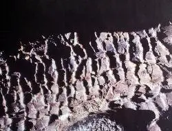
Tree Molds Trail
Visitors Center, Craters of the Moon National Monument
0.0 miles SWA paved trail winding through Craters of the Moon Wilderness to a lava flow that captured the shapes of fallen and standing trees in cooling rock — look for wooden posts marking the molds.
Hike 0.1 mi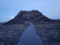
Spatter Cones
Visitors Center, Craters of the Moon National Monument
1.1 miles NWMiniature volcanoes formed by lobbed molten lava blobs at Craters of the Moon — a must-see feature that symbolizes this unique national monument; stay on trails to protect the delicate spatter cones.
Hike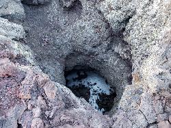
Snow Cone
Visitors Center, Craters of the Moon National Monument
1.1 miles NWHike near Visitors Center, Craters of the Moon National Monument
Hike 1.8 mi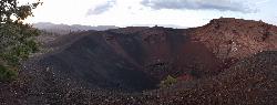
North Crater Trail
Visitors Center, Craters of the Moon National Monument
1.1 miles NWA one-way trail through North Crater and Big Craters at Craters of the Moon — dropping into a volcanic crater mouth and ending at Spatter Cones, with fragile lava formations off-limits to protect.
Hike 0.4 mi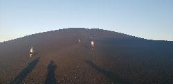
Inferno Cone
Visitors Center, Craters of the Moon National Monument
1.1 miles NA steep climb up Inferno Cone at Craters of the Moon, rewarded with panoramic views of the Great Rift, Snake River Plain, and Pioneer Mountains — and on clear days, the Tetons 100 miles away.
Hike 1.0-1.3 mi
Caves Trail
Visitors Center, Craters of the Moon National Monument
1.5 miles NECave and Hike near Visitors Center, Craters of the Moon National Monument
Cave, Hike 0.5 mi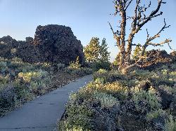
Devil's Orchard Trail
Visitors Center, Craters of the Moon National Monument
1.7 miles NA paved, wheelchair-accessible trail through cinder beds and ancient North Crater wall fragments, with exhibits on protecting this fragile volcanic environment.
Hike
North Crater Flow
Arco, Idaho
2.1 miles NHike near Arco, Idaho
Hike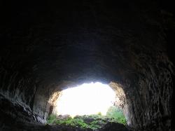
Bear Trap Cave
American Falls, Idaho
32.2 miles SA lava tube estimated to be 15,000 years old, traceable for nearly 15 miles, originating from the Great Rift near Craters of the Moon — a window into Idaho's volcanic past.
Cave 0.6 mi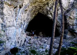
Hidden Mouth Cave
Moore, Idaho
37.4 miles NA surprisingly large lava cave with three chambers and a secret back exit — reached by quad or a quarter-mile steep hike above Moore, Idaho.
Cave, Hike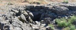
Lariat caves
American Falls, Idaho
39.6 miles SEA massive lava tube near Craters of the Moon with a fun back loop, constant temperature year-round, and history as a Boy Scout backcountry camp site.
Cave
Kimama Wind Caves
Paul, Idaho
48.5 miles SA labyrinth of lava tubes in the desert north of Paul — tight crawls, varying ceiling heights, and graffiti throughout — strictly for experienced cavers with proper lights.
Camp, Cave
Maze Cave
West Magic, Idaho
49.6 miles SWA two-tunnel cave with upper and lower passages that meet at the back — a fun, compact cave to explore next to the T Cave near West Magic, Idaho.
Cave
T Cave
West Magic, Idaho
49.6 miles SWA cave just north of Gwinn and Mammoth Cave in West Magic, Idaho — enter and travel back about 300 yards to a large T-junction with passages extending roughly a quarter mile each way.
Cave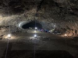
Gwinn & Gwinn Cave
West Magic, Idaho
49.9 miles SWGwinn and gwinn cave is located near the famous Idaho Mammoth cave this cave you decend down a ladder and cave goes back in at least a quarter mile. great spot to camp
CaveNearby Campsites

Lava Flow Campground
Arco, Idaho
2.3 miles NA campground surrounded by a young lava flow near the Craters of the Moon visitor center and popular trails — 42 first-come sites at $15/night during main season.
Camp
Kimama Wind Caves
Paul, Idaho
48.5 miles SA labyrinth of lava tubes in the desert north of Paul — tight crawls, varying ceiling heights, and graffiti throughout — strictly for experienced cavers with proper lights.
Camp, Cave


