


Hickory Creek Park
Lowell

Camp and Swim
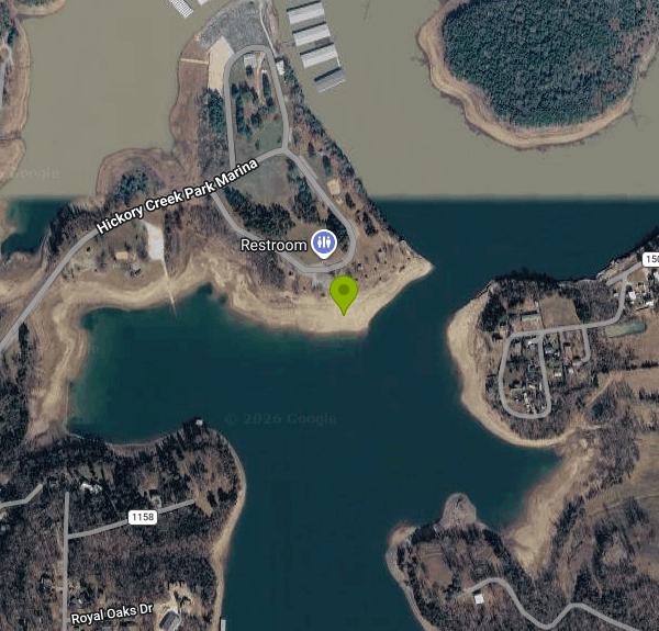
Hickory Creek Park is a U.S. Army Corps of Engineers park on Beaver Lake, the White River reservoir in the Ozark hills of northwest Arkansas. It sits at the end of Hickory Creek Road in Benton County, roughly 6 miles east of Lowell, and is run by the Corps' Beaver Lake Project Office. The park mixes a 61-site campground split between the Hickory Creek and Pine loops, two reservable group shelters, a boat ramp and a privately run marina. The swim beach is in the day-use area on the point east of the marina, on its south-facing shore, where a line of buoys marks off the swimming water from the rest of the lake.
From Rogers, take Highway 264 east for about 4.5 miles, turn right on Cow Face Road, then after a mile turn left on Hickory Creek Road. The park entrance is on the right about a mile later (the posted address is 12618 Hickory Creek Road, Lowell). Inside the gate, follow the road across the narrow causeway past the West shelter and the launch ramp, then onto the day-use point. A paved loop with parking runs just above the beach, so the walk down to the water is short. Park on pavement only; the Corps prohibits parking on the grass.
The beach itself is a sloping bank of sand and gravel that runs down into open water facing south across the lake. How much beach you get depends heavily on the lake level. Beaver Lake's normal pool is 1,120 feet, and in a dry late summer the water drops and leaves a wide strip of exposed sand and rock between the grass and the buoys. In a wet spring the lake can climb into the picnic area and parking lot. The shallows by the shore warm up through the summer, but this is a deep reservoir and the water gets cooler and deeper beyond the buoy line. None of the Corps' material for the park mentions lifeguards, so plan on watching your own group.
Campers swim free with their site. Everyone else pays the Corps' $5 area use fee per vehicle when entering the park, and the receipt or a valid pass has to be displayed. The gates to the day-use area are locked at sunset. The Corps lists no separate charge for the beach beyond that vehicle fee.
Check conditions before you go. The Corps tests Beaver Lake's swim beaches for bacteria and closes them when E. coli levels run high; Hickory Creek was on the closure list in May 2024 and in another June closure, reopening each time once follow-up samples came back clean. After heavy storms the Corps has also shut the Hickory Creek Day Use Area beach for high water, floating logs and submerged debris, and a 2022 closure for flood debris lasted weeks. The marina and launch ramp sit close by, so expect boat traffic and stay inside the buoys. The Beaver Lake Project Office (479-636-1210) can tell you the current beach status.
Beyond the beach, the day-use point has picnic sites, a playground and horseshoe pits next to the Bluff shelter, though the shoreline there is steep bluff rather than beach. The campground loops line the shore north and west of the marina, and the marina handles boat slips and supplies. Anglers come for largemouth and smallmouth bass, crappie, white bass, stripers and catfish, and the launch ramp gives boaters direct access to the main lake.
More Information
Beaver Lake - Camping | Arkansas | Recreation.gov
Reserve camping, permits & activities at Beaver Lake, Arkansas. 11 campgrounds. Book official reservations on Recreation.gov.
https://www.recreation.gov/camping/gateways/530Beaver Lake swim beaches close due to E. coli levels and debris | Arkansas News | koamnewsnow.com
Beaver Lake courtesy US Army Corps of Engineers at Little Rock. BENTON COUNTY, Ark. — According to a release from the US Army Corps of Engineers at Little Rock, several
https://www.koamnewsnow.com/news/arkansas-news/beaver-lake-swim-beaches-close-due-to-e-coli-levels-and-debris/article_449a9215-e3a2-5fcb-bd59-0a3a8282ae03.htmlHickory Creek Park (AR), Beaver Lake - Recreation.gov
Explore Hickory Creek Park (AR) in Beaver Lake, Arkansas with Recreation.gov. Hickory Creek Park sits along the vast shores of Beaver Lake in the Ozark Mountains of Northwest Arkansas, offering spacious and sunny campsites and an abundanc
https://www.recreation.gov/camping/campgrounds/232601High water forces temporary closure of three Beaver Lake swim beaches for safety
High water, debris prompt closure of several swim beaches at Beaver LakeROGERS, Ark. – The U.S. Army Corps of Engineers, Beaver Lake Project Office is temporari
https://www.katv.com/news/local/high-water-forces-temporary-closure-of-three-beaver-lake-swim-beaches-for-safetyMultiple swim beaches closed at Beaver Lake due to high E. coli levels
The U.S. Army Corps of Engineers (USACE) has closed several swimming beaches at Beaver Lake due to higher than acceptable E. coli levels.
https://www.ky3.com/2024/05/18/multiple-swim-beaches-closed-beaver-lake-due-high-e-coli-levelsSite Bluff, Hickory Creek Park (AR) - Recreation.gov
Find out more details and check site availability for Site Bluff, Loop HICKORY CREEK in Hickory Creek Park (AR) at Beaver Lake with Recreation.gov.
https://www.recreation.gov/camping/campsites/44558Site West, Hickory Creek Park (AR) - Recreation.gov
Find out more details and check site availability for Site West, Loop HICKORY CREEK in Hickory Creek Park (AR) at Beaver Lake with Recreation.gov.
https://www.recreation.gov/camping/campsites/44500Swim beach closed due to E-coli contamination at Beaver Lake, another reopened
The U. S. Army Corps of Engineers, Beaver Lake Office announced on Tuesday one of the swim beaches is temporarily closing, while another has reopened, according to news releases.
https://digital-release.nwahomepage.com/news/swim-beach-closed-due-to-e-coli-contamination-at-beaver-lake-another-re-opened/amp/USACE permanently closing two swim beaches at Beaver Lake, here’s why
The U.S. Army Corps of Engineers says two swim beaches at Beaver Lake are permanently closing, the department announced Tuesday.
https://www.yahoo.com/news/usace-permanently-closing-two-swim-112453075.html
- Plan Ahead and Prepare
- Travel & camp on durable surfaces
- Dispose of waste properly
- Leave what you find
- Minimize campfire impacts
- Respect wildlife
- Be considerate of other visitors
Directions
From Lowell
- Head southwest on Dutton St toward Market St (0.4 mi)
- Keep right to continue on Thorndike St (0.5 mi)
- Slight right (signs for I-495/
US-3) (0.2 mi) - Merge onto Lowell Connector (1.7 mi)
- Take exit 2A-2B for I-495 S toward Worcester (0.5 mi)
- Merge onto I-495 S via the ramp to Marlboro (23.9 mi)
- Take exit 65B to merge onto I-290 W toward Worcester (20.1 mi)
- Take exit 12A for I-90/
MA-12 N toward Massachusetts Turnpike/ Auburn (0.2 mi) - Take the ramp onto I-90 WToll roadEntering New York(108 mi)
- Continue onto NY-912M WToll road(6.6 mi)
- Take exit 22-61 to merge onto I-87 N toward I-90/
Albany/ Buffalo Toll road(14.2 mi) - Continue onto Governor Thomas E. Dewey Thruway/
NY State Thruway (1.2 mi) - Merge onto I-90 WToll roadPassing through PennsylvaniaEntering Ohio(446 mi)
- Keep right to stay on I-90 W, follow signs for I-271 S/
Cleveland (1.3 mi) - Keep left to continue on I-271 S (12.2 mi)
- Continue straight to stay on I-271 S (9.1 mi)
- Keep right to stay on I-271 S (18.5 mi)
- Continue onto Exit 1 (signs for I-71 S/
Columbus) (0.6 mi) - Merge onto I-71 S (101 mi)
- Take exit 119B to merge onto I-270 W (17.0 mi)
- Take exit 8 to merge onto I-70 W toward DaytonEntering Indiana(162 mi)
- Keep left to stay on I-70 W (3.4 mi)
- Keep left to stay on I-70 W, follow signs for I-65 S/
Michigan St/ Ohio St/ Fletcher Ave (0.1 mi) - Continue onto I-70 W (0.1 mi)
- Keep left to stay on I-70 W, follow signs for I-65 S/
Michigan St/ Ohio St/ Fletcher Ave (0.5 mi) - Merge onto I-65 S/
I-70 W (1.7 mi) - Keep right to continue on I-70 W, follow signs for St Louis/
Indpls. Int'l Airport Entering Illinois(144 mi) - Keep right to stay on I-70 W, follow signs for St Louis (76.9 mi)
- Take the exit onto I-55 S/
I-70 W toward St Louis (16.7 mi) - Keep left to continue on I-55 SEntering Missouri(3.4 mi)
- Take exit 40B to merge onto I-44 W/
I-55 S (1.3 mi) - Slight right onto I-44 W (signs for Tulsa) (245 mi)
- Take exit 44 toward Monett (0.2 mi)
- Turn left onto I-44BL W/
State Rd H/ State Rte H Continue to follow State Rd H/(3.3 mi)State Rte H - Turn left to stay on State Rd H/
State Rte H (4.9 mi) - Turn left onto State Rd H/
State Rte H/ Lawrence 1080 Continue to follow State Rd H/(6.1 mi)State Rte H - Turn right onto E Cleveland Ave (0.5 mi)
- Turn left onto N Central Ave (0.6 mi)
- Continue onto W Broadway St (0.2 mi)
- Continue onto State Hwy 37 S/
N Lincoln Ave Continue to follow State Hwy 37 SEntering Arkansas(33.5 mi) - Turn right onto US-62 W (15.3 mi)
- Turn left onto AR-12 E/
N 2nd St (1.2 mi) - Turn left onto W Locust St (0.1 mi)
- Turn right onto N Arkansas St (0.8 mi)
- At the traffic circle, continue straight onto S 1st St (4.3 mi)
- Continue onto AR-265 S (2.8 mi)
- Turn left onto AR-264/
E Hwy 264 (3.0 mi) - Turn right onto Cow Face Rd (1.3 mi)
- Turn left onto Hickory Creek Rd (0.8 mi)
- Turn right onto Hickory Creek Park Marina (299 ft)
- Turn right to stay on Hickory Creek Park Marina (0.4 mi)
- Turn right to stay on Hickory Creek Park Marina (0.2 mi)
- Turn right (249 ft)


Other Swimming Holes Nearby
Prairie Creek Swimming Area
Rogers
8.2 miles NPrairie Creek is a U.S. Army Corps of Engineers swim beach on Beaver Lake, three miles east of Rogers, where a buoy line marks off a sandy cove inside the day use area. There is no lifeguard, and the Arkansas Department of Health samples the water for E.
Camp, Canoe, Kayak, Swim
The Cliffs at Beaver Lake
Larue, Arkansas
9.3 miles NEColorful limestone bluffs towering over clear, cool Beaver Lake water — cliff jump, explore by kayak along five miles of bluff, or look for small hidden waterfalls.
Swim
Hogscald Hollow
Eureka Springs, Arkansas
12.5 miles NEAn adventurous Beaver Lake swimming hole near Eureka Springs with cliff jumps, from gentle 10-footers to a 50-foot Lover's Leap.
Canoe, Kayak, Swim
Eureka Springs Area
Heber Springs, Arkansas
12.7 miles NEThe Beaver Lake and King River area near Eureka Springs hides several laid-back swimming holes in northwest Arkansas, some with very optional dress codes.
Swim
Tanyard Creek Falls
Mammoth Spring, Arkansas
20.7 miles NWA two-mile forested loop to a mossy, multi-tiered waterfall in Bella Vista — perfect wading pools await at the base, with cool, clean water on an easy trail for all levels.
Swim
Trigger Gap
Eureka Springs, Arkansas
21.0 miles EA mild river kayaking stretch on Kings River with calm current, cool clear water, and rental canoes, kayaks, and paddleboards from $30–$80 at Trigger Gap Outfitters — great for beginners.
Canoe, Kayak, Swim
Riverside Park
West Fork, Arkansas
23.2 miles SA low concrete dam creates an impressive rushing waterfall above colorful cliffs in West Fork, with deep swimming water, fishing, sunbathing, a pavilion, and short walking trails.
Swim
Kings River Falls
Sheridan, Arkansas
34.4 miles SEA unique waterfall dropping from a wide red rock shelf into a pool — sometimes roaring wall-to-wall, sometimes trickling — on an easy two-mile round-trip hike.
Hike, Swim
Cedar Flats
Banyard, Arkansas
35.2 miles SWSpring-fed Cedar Flats stays cool and clear all year, with large rock shelves for lounging near Devils Den State Park — an old rope swing is on site, so swim and swing at your own risk.
Swim
Ponca Bridge
Ponca, Arkansas
40.0 miles EBright blue water teeming with fish, a concrete bridge jump, rocky shallows for wading, and elk sightings nearby — Ponca Bridge is an easy-access swimming hole in Arkansas.
Hike, Swim
Lee Creek Access
Chester, Arkansas
40.7 miles SWA smooth, deep, wide stretch of Lee Creek with a sandy beach, a kayak and canoe launch, camping spots with fire circles, and peaceful surroundings for a summer swim.
Camp, Canoe, Kayak, Swim
Mulberry River Area
Umpire, Arkansas
40.8 miles SSwim near Umpire, Arkansas
Swim
Ponca Area
Morrilton, Arkansas
41.1 miles ESwim near Morrilton, Arkansas
Swim
Natural Dam
Cedarville, Arkansas
45.7 miles SWA naturally formed rock wall creates a 200-foot-wide waterfall and a cool swimming hole on Mountain Fork Creek — parking lot access makes this one of the easiest swimming holes to reach in Arkansas.
Swim
Moon Shine Beach
Branson, Missouri
47.4 miles NEA spacious sandy beach on Table Rock Lake with easy sloped water access, volleyball, a playground, and beautiful sunrises and sunsets over the large clear lake and surrounding hickory forest.
Swim
Rocky Ford State Park
Tahlequah, Oklahoma
49.4 miles WRocky Ford is one of the most popular spots to cool off along the scenic Illinois River near Tahlequah, in the green hills of northeastern Oklahoma. A favorite local swimming and float destination,...
Swim
Bradley Park
Jasper, Arkansas
49.5 miles EThe Little Buffalo River flows through this wooded Jasper park, with walking paths, fishing, picnic tables, calm deep swimming water, and easy kayak and canoe access.
SwimNearby Campsites
Prairie Creek Swimming Area
Rogers
8.2 miles NPrairie Creek is a U.S. Army Corps of Engineers swim beach on Beaver Lake, three miles east of Rogers, where a buoy line marks off a sandy cove inside the day use area. There is no lifeguard, and the Arkansas Department of Health samples the water for E.
Camp, Canoe, Kayak, Swim
Lee Creek Access
Chester, Arkansas
40.7 miles SWA smooth, deep, wide stretch of Lee Creek with a sandy beach, a kayak and canoe launch, camping spots with fire circles, and peaceful surroundings for a summer swim.
Camp, Canoe, Kayak, Swim


