


Map of 857 Hiking Trails in United States
first prev 1 2 3 4 5 6 7 8 9 10 next lastShowing Hiking Trails in United States City, Zip, or Address

Bear Gulch
Ashton, Idaho
9.7 miles NE of Ashton, IdahoBear Gulch is an abandoned ski hill out of operation since 1969. While the vegetation is beginning to take over, there's still some great sledding to be had. It's just far enough into the...
Camp, Cross-country Ski, Hike, Sled
Big Springs
Island Park, Idaho
7.6 miles NE of Island Park, IdahoThere's also a great little walking trail along the river with placards that tell about the ecosystem and history of the area. There's about a 1/2 mile that's paved and then a 1/2 mile...
Camp, Hike 3.8-6.4 mi
Table Rock / Table Mountain
Driggs, Idaho
10.0 miles E of Driggs, IdahoAt 11,300 feet, Table Mountain is possibly the most beautiful climb this side of the Tetons and offers what may well be the very best view of the Grand Tetons. It's just far enough away...
Camp, Hike 0.3-5.1 mi
Jenny Lake Trail
Jackson Hole, Wyoming
19.7 miles N of Jackson Hole, WyomingOne of the most popular trails to visit in Grand Teton is the Jenny Lake Trail. The Jenny Lake Trail, located near Moose, Wyoming, is an easy trail that loops around the lake. Along with the sheer...
Hike 0.4 mi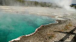
West Thumb Geyser Basin
Grant Visitor's Center, Yellowstone National Park
1.8 miles NW of Grant Visitor's Center, Yellowstone National ParkWest Thumb Geyser Basin is one of the smaller geyser basins in Yellowstone, yet its location along the shore of Yellowstone Lake and is ranked as the most scenic. This area was formed by volcanic...
Hike 5.6-8.3 mi
Palisades Creek Trail / Lakes and Waterfall Canyon
Irwin, Idaho
4.4 miles E of Irwin, IdahoPalisades Creek Trail is located about 50 miles southeast of Idaho Falls and about 60 miles west of Jackson Hole WY in Swan Valley Idaho. The four mile hike up to lower Palisades Lake or the 6.2 mile...
Backpack, Camp, Hike, Horseback, Mountain Bike 0.1 mi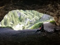
40 Horse Cave
Firth, Idaho
11.9 miles E of Firth, IdahoThe naming of the cave comes from a story of two men who were caught in a bad storm. Upon hiking, these two guys were able to find the cave. One of them commented to the other, "This cave could...
Cave, Hike
Fall Creek Falls
Swan Valley, Idaho
2.1 miles SW of Swan Valley, IdahoFalls Campground is located next to the Snake River near beautiful Swan Valley, only 45 miles east of Idaho Falls, Idaho. Mixed growth cottonwood trees provide partial shade, and grassy meadows with...
Camp, Cave, Hike, Kayak, Swim 0.5-3.5 mi
Webster's Dam
Ririe, Idaho
9.8 miles NE of Ririe, IdahoAlso known as Manmade Falls or the Woodmansee Dam, Webster Dam is an abandoned dam located deep in Moody Creek canyon, the dam was abandoned when sediment built up behind the dam which then...
Camp, Hike, Mountain Bike 1.9-2.9 mi
Mist Trail
Yosemite National Park
9.2 miles S of Yosemite National ParkThe mist trail is a small breakoff from the John Muir Trail through Yosemite National Park. It's called the mist trail because of the heavy amount of mist that hikers walk through as Vernal and...
Backpack, Hike
Antelope Island State Park
Syracuse, Utah
10.0 miles SW of Syracuse, UtahLocated just 41 miles north of Salt Lake City, Antelope Island State Park encompasses a vast selection of outdoor activities and spectacular scenery providing a peaceful nature experience. Experience...
Backpack, Camp, Hike, Horseback, Mountain Bike 0.1-0.5 mi
Eagle Park
Rexburg, Idaho
0.9 miles N of Rexburg, IdahoEagle Park is a little urban oasis. Once you drive in to this cottonwood forest along the river, you may forget that you're still inside Rexburg city limits. You can camp, picnic, throw rocks in...
Camp, Hike, Mountain Bike, Sled 0.3-0.6 mi
Cress Creek Nature Trail
Rexburg, Idaho
11.9 miles S of Rexburg, IdahoMeandering along the scenic South Fork of the Snake River, the beautiful 1¼ mile Cress Creek Nature Trail will lead you on a journey through sagebrush-grass communities, over juniper covered...
Hike 0.9 mi
Hell's Half Acre Lava Walk
Blackfoot, Idaho
25.6 miles N of Blackfoot, IdahoThe Lava Trails traverse the desert of the Snake River Plain through contorted landscapes created from multiple lava flows. These Hawaiian-type lava flows are associated with the stretching of the...
Hike 0.6 mi
Packsaddle Lake
Tetonia, Idaho
9.3 miles W of Tetonia, IdahoPacksaddle is one of the less well known lakes/trails in the area. If you've got a good offroad vehicle, you can probably make it all the way to the end of the road, otherwise, it's just an...
Dive, Hike, Mountain Bike, Snowshoe, Swim 0.6-2.0 mi
North Menan Butte ('R' Mountain)
Menan, Idaho
4.5 miles N of Menan, IdahoThe North Menan Butte is more commonly known to the locals and college students as R Mountain. Many kids know it better as Ou'R' Mountain. The butte is a rare and unique geological area and provides...
Camp, Cave, Hike 13.8 mi
Big Elk Creek
Irwin, Idaho
11.0 miles SE of Irwin, IdahoBig Elk Creak Campground is a very versitile campground with plenty of activities to keep busy. Campgrounds are available, with three group sites that include picnic tables and campfire rings. There...
Backpack, Camp, Canoe, Hike, Horseback, Kayak
Murphy Lakes
Bedford, Wyoming
11.4 miles N of Bedford, WyomingCanoe, Hike, and Swim near Bedford, Wyoming
Canoe, Hike, Swim
Scout Mountain Campground
Pocatello, Idaho
13.1 miles S of Pocatello, IdahoScout Mountain Campground is located on beautiful Scout Mountain at an elevation of 6,900 feet, just 13 miles south of Pocatello, Idaho. Scout Mountain is part of the Mink Creek area, a popular...
Camp, Hike 1.0-7.5 mi
Idaho Falls Greenbelt
Idaho Falls, Idaho
0.5 miles NW of Idaho Falls, IdahoThe Idaho Falls Greenbelt is one of Idaho Falls charms located in the heart of Idaho Falls, next to the historic Idaho Falls downtown. The paved foot-trail is approximately 6 miles around,...
Hike


