


North Menan Butte ('R' Mountain)
Menan, Idaho

| Address: | 1099 N 3600 E, Menan, ID 83434 |
| GPS: |
43°47'7.7"N 111°59'24.6"W Maps | Directions |
| State: | Idaho |
| Trails/Routes: | 0.6-2.0 mi |
Restrooms Trails
Camp, Cave, and Hike
The North Menan Butte is more commonly known to the locals and college students as R Mountain. Many kids know it better as Ou'R' Mountain. The butte is a rare and unique geological area and provides a great volcanic hike.
There's a paved parking lot and a vault toilet at the West trailhead. The first few hundred yards are well-maintained gravel and sand paths and the further you get, the less defined the trail gets, though it is relatively easy to find and follow. The switchback trails (South and West) are marked by sections of log fences. Towards the top of the West switchbacks, there's a chain handrail. It gets a little steep so you'll want some shoes with some grip. The sand on the rock makes it pretty slippery in the steeper parts. You'll get better grip after a good rain. Once you get up to the top, there's an informational placard. From there, it's easy to hike the rim and get an awesome view of the valley including Rexburg, Henry's Fork, and the Snake River.
It's a great hike for a small family or just a quick hike for a date. Even going up the West switchbacks and around rim, including the 'R', and back down the same way is only 3.5 miles (longest route) so you can do it pretty quick if you want. There's so much to look at that you could also spend hours climbing rocks, exploring caves, and playing around "The Ampitheater". If you just want to get to the 'R' as quickly as possible, you can do the hike in as little as 2 miles roundtrip.
Distances:
- West trailhead up the face to the rim: 0.5 miles
- West trailhead up the switchbacks to the rim: 0.75 miles
- West trailhead, from reaching the rim to 'R': 1 mile
- South trailhead to the rim: 0.3 miles
- South trailhead, from reaching the rim to 'R': 0.75 mile
- Through the caldera: 0.6 miles
- Around the rim: 2 miles
- Rim to 'R': 500 feet
There are no fees. Camping is allowed up to 5 nights but fires must be in an elevated fire pan and all the ash must be packed out.
Posted regulations:
- No motorized vehicle use
- Discharging of weapons or fireworks is prohibited
- Open fires are permitted only with an approved elevated fire pan and ash removal
- Burning pallets, tires, wire, plastic, glass, metal, magnesium, or hazardous material is prohibited
- Cutting or damaging vegitation is prohibited
- 5-day camping limit
More Information
Menan Buttes, East Idaho
The Menan Buttes in eastern Idaho are a pair of pair of isolated cones of volcanic tuff overlooking the Snake River, one of which is open to hiking; interesting geology and far-reaching views
https://www.americansouthwest.net/idaho/menan-buttes/index.htmlBe courteous, informed, and prepared. Read trailhead guidelines, stay on the trail, and don't feed the wildlife.
Read More- Plan Ahead and Prepare
- Travel & camp on durable surfaces
- Dispose of waste properly
- Leave what you find
- Minimize campfire impacts
- Respect wildlife
- Be considerate of other visitors
Directions
From Menan, Idaho
- Head east on E Menan Lorenzo Hwy toward N 3565 E (0.3 mi)
- Turn left onto N 3600 EDestination will be on the right(4.6 mi)
tward
4/27/20 4:42 pmkatiemia
9/10/16 2:01 pmendovereric
6/18/13 11:33 pm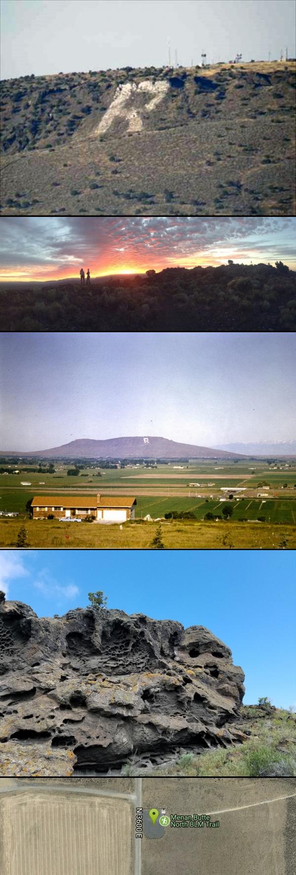


Other Hiking Trails and Caves Nearby

Lorenzo Boat Ramp
Rigby, Idaho
6.5 miles SEHike and Kayak near Rigby, Idaho
Hike, Kayak 1.0-1.3 mi
Lorenzo Bridge
Rexburg, Idaho
7.2 miles SEA quiet former boat launch with primitive riverside trails, a hidden lake, stunning fall colors, and a natural paintball field bounded by river and dry creek bed.
Airsoft, Hike, Paintball 2.1-2.3 mi
Market Lake Wildlife Management Area
Roberts, Idaho
7.6 miles WA wildlife management area teeming with waterfowl — ibis colonies, ducks, geese, herons, eagles, hawks, and owls — plus mule deer, white-tailed deer, and a small moose population near Roberts, Idaho.
Hike, Horseback 0.2-0.5 mi
Eagle Park
Rexburg, Idaho
10.2 miles EA cottonwood forest park inside Rexburg city limits with campsites, fishing, a dog park, mountain biking on easy and moderate loops, and rock-throwing by the river.
Camp, Hike, Mountain Bike, Sled 0.1-1.3 mi
Hidden Valley Trails
Rexburg, Idaho
11.5 miles EA well-signed network of downhill singletrack flows around the edges of Rexburg, with trails like Flow State, Drop Zone, and Lil' Sendy for every ability level.
Hike, Mountain Bike 0.3-0.6 mi
Cress Creek Nature Trail
Rexburg, Idaho
16.2 miles SEA 1.25-mile self-guided nature trail along the South Fork of the Snake River through sagebrush, juniper slopes, and lush creekside habitat — with an overlook trail, caves near the rim, and moose sightings.
Hike
Herbert Idaho Ghost Town
Ririe, Idaho
17.4 miles ECLOSED. Private property marked NO TRESPASSING. The quiet ghost of a farming and mining community that once housed 150 people — Herbert, Idaho faded with the automobile, and the old house was lost to vandals around 2017.
Hike
Henry's Fork Green Way (St. Anthony Green Belt)
Saint Anthony, Idaho
19.2 miles NEAn easy paved 2-mile round-trip riverside walk along Henry's Fork in Saint Anthony — a statue of fur trader Andrew Henry at the halfway loop, and a pet-friendly, beginner-friendly path.
Hike 1.0-7.5 mi
Idaho Falls Greenbelt
Idaho Falls, Idaho
20.1 miles SA 6-mile paved riverside trail through the heart of Idaho Falls past a 22-foot waterfall that stretches 600 feet wide, historic landmarks, parks, and downtown restaurants.
Hike 0.5-3.5 mi
Webster's Dam
Ririe, Idaho
20.5 miles EAn abandoned dam in Moody Creek canyon where sediment split the stream into two beautiful 15-foot waterfalls — stunning in spring runoff and blazing with fall colors.
Camp, Hike, Mountain Bike 3.8 mi
Stinking Springs
Ririe, Idaho
21.0 miles SEAn ATV and dirt bike trail that doubles as a mountain bike gem — progressively bermed switchbacks, rock rolls, and gardens lead to connections with Kelly Canyon and the broader Big Hole range.
Hike, Mountain Bike 3.8 mi
Kelly Mountain Trail
Ririe, Idaho
21.6 miles SEA moderate uphill trail open to hikers, mountain bikers, and ATVs, winding through hills with wildflower and mountain views — dogs welcome on leash.
Cross-country Ski, Hike, Mountain Bike, Snowshoe 1.7 mi
Buckskin Morgan Ridge
Ririe, Idaho
22.0 miles SEA punchy climb to Buckskin Morgan Ridge pays off with twisty singletrack descents through roots, loose rock, and rolling hills above the Snake River Plain.
Hike, Mountain Bike 1.1 mi
Hidden Vista / Pine Loop
Ririe, Idaho
22.0 miles SEA short singletrack trail to a canyon overlook with Snake River views — then a detour east for fun climbs, turns, rocks, and jumps on the way back to the Buckskin Morgan parking lot.
Hike, Mountain Bike
Poison Flats
Ririe, Idaho
22.3 miles SEHike near Ririe, Idaho
Hike 0.6-2.2 mi
Fish Creek Area
Ririe, Idaho
22.9 miles EThe Big Hole Mountains' Fish Creek trail network serves up singletrack climbs, floater jumps, rock gardens, and fast Fishbone descents accessed from Ririe or Rexburg.
Hike, Mountain Bike
17 Mile Cave
Idaho Falls, Idaho
24.8 miles SWA lava tube just 17 miles from Idaho Falls with a nearly flat quarter-mile tunnel ending in two cool pools — easy for beginners, though expect graffiti on the walls.
Cave, Hike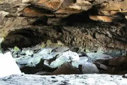
Civil Defense Caves
Rexburg, Idaho
27.7 miles NETwo large lava tubes with an arched ceiling, gravel floor, bats in the left branch, and a cavern section at the end — open May through September to protect the bat habitat.
Cave 0.9 mi
Hell's Half Acre Lava Walk
Blackfoot, Idaho
27.7 miles SWTwo lava trails — a quick half-mile loop or a 4.5-mile route to the main vent — trace a 4,100-year-old 222-square-mile eruption across the Snake River Plain.
Hike
Burns Canyon
Ririe, Idaho
28.9 miles SEHike and Mountain Bike near Ririe, Idaho
Hike, Mountain BikeNearby Campsites

Beaver Dick Park
Rexburg, Idaho
5.0 miles NEA 9.5-acre Snake River park near Rexburg with fire pits, pavilions, fishing, boating, swimming, and a rich history tied to legendary frontiersman Beaver Dick Leigh.
Camp, Canoe, Disc Golf, Swim
Jefferson County Lake (AKA Rigby Lake)
Rigby, Idaho
7.4 miles SESandy beaches, two floating docks with a slide, volleyball, playgrounds, and a safe swim zone — Jefferson County Lake is eastern Idaho's go-to summer swimming spot.
Camp, Canoe, Dive, Kayak, Sled, Swim 0.8-1.3 mi
Warm Slough Campground
Rexburg, Idaho
8.5 miles NEA popular river campground with two boat ramps and an easy, slow-moving inner tube float — the take-out is 1,000 feet from the put-in, making multiple runs a breeze.
Airsoft, Camp, Canoe 0.2-0.5 mi
Eagle Park
Rexburg, Idaho
10.2 miles EA cottonwood forest park inside Rexburg city limits with campsites, fishing, a dog park, mountain biking on easy and moderate loops, and rock-throwing by the river.
Camp, Hike, Mountain Bike, Sled
Twin Bridges Park
Rexburg, Idaho
13.7 miles SEA 27-acre Snake River park between two bridges near Rexburg with shaded campsites, fire pits, pavilions, a playground, and BLM ground for hiking and hunting on three sides.
Camp, Canoe
Paramount Wall / Blanche Rock
Ririe, Idaho
19.7 miles SEA sport climbing wall above the road near Ririe with great exposure, afternoon shade, and well-loved 5.9–5.10 lines — most routes work with a 50-meter rope, established by Chuck Oddette and crew.
Camp, Horseback, Rock Climb
Kelly Island Campground
Ririe, Idaho
19.8 miles SEA BLM campground with 14 family sites and 1 group site for RVs or tents, open May through September — vault toilets, pets welcome, and rates from $5–$20 per night.
Camp 0.5-3.5 mi
Webster's Dam
Ririe, Idaho
20.5 miles EAn abandoned dam in Moody Creek canyon where sediment split the stream into two beautiful 15-foot waterfalls — stunning in spring runoff and blazing with fall colors.
Camp, Hike, Mountain Bike
Big Hole Dispersed Campsites
Ririe, Idaho
20.7 miles EA network of dispersed campsites with fire rings in the Big Hole mountains above Kelly Canyon — first come, first served, no reservations, and Leave No Trace principles are essential.
Camp
Table Rock Campground
Ririe, Idaho
22.7 miles SEA campground in Caribou-Targhee National Forest — part of a 3-million-acre stretch from Montana to the Utah and Wyoming borders — with access to the Curlew National Grassland.
Camp
Wolf Flats Recreation Area
Ririe, Idaho
23.0 miles SEWolf Flats is a completely free, dispersed, undeveloped camping area with 25 locations to camp. Some areas are large enough to accommodate groups of 50 people.
Camp
Sealander Park
Idaho Falls, Idaho
25.5 miles SA peaceful 15-acre park steeped in Idaho homesteader history — listed on the National Register of Historic Places, Sealander Park is available to reserve for picnics, reunions, weddings, and retreats.
Camp
Moody Meadows
Driggs, Idaho
27.3 miles EGood place for kids, they can ride bikes in the meadow, play in the stream, and camping is off of the road. Hiking, motorbiking, and horseback riding trails are abundant in the area.
Camp
Pine Butte / The Caldera
St. Anthony, Idaho
34.1 miles NAn old volcano in the Idaho desert that feels like stepping into a mountain forest — pine-covered hillsides, a meadow ringed by aspen and boulders, and a quarter-mile easy trail to the caldera floor.
Camp, Hike, Horseback
Firth River Bottoms
Firth, Idaho
34.6 miles SA community riverside park in Firth with horseback riding, picnicking, fishing, and baseball — something for the whole family along the river bottoms.
Camp, Canoe, Hike
Fall Creek Falls
Swan Valley, Idaho
38.9 miles SEA shaded Snake River campground near Swan Valley with abundant wildlife, great trout fishing, and Fall Creek Falls a quarter-mile away.
Camp, Cave, Hike, Kayak, Swim
Falls Campground
Victor, Idaho
39.8 miles SEA Snake River campground near Swan Valley with cottonwood shade, abundant wildlife — eagles, osprey, moose, and deer — and Fall Creek Falls just a quarter mile away; Palisades Reservoir is 20 miles out.
Camp
Warm River Campground
Ashton, Idaho
41.0 miles NESlow-moving warm water and willow-lined banks make this campground a perfect spot for tubing, trout fishing, and peaceful mountain biking at 5,200 ft elevation.
Camp
Pine Creek Campground
Victor, Idaho
41.9 miles EThe Pine Creek Campground has 10 single units and has restrooms.
Camp 0.3-0.6 mi
Bear Gulch
Ashton, Idaho
43.1 miles NEAn abandoned ski hill from 1969 with overgrown runs that still deliver great sledding — the lower run is fast and winding all the way down to the old ski lift.
Camp, Cross-country Ski, Hike, Sled


