


81 Hiking Trails near The Pit
first prev 1 2 3 4 5 next lastShowing Hiking Trails within 50 miles Distance miles of Forest Rd 309, Ashton, ID 83420, USA City, Zip, or Address

Webster's Dam
Ririe, Idaho
35.3 miles SWAlso known as Manmade Falls or the Woodmansee Dam, Webster Dam is an abandoned dam located deep in Moody Creek canyon, the dam was abandoned when sediment built up behind the dam which then...
Camp, Hike, Mountain Bike 2.1-11.5 mi
Lewis River Channel / Dogshead Loop
Grant Village, Yellowstone National Park
35.8 miles EAnyone who doesn't want to backpack through Yellowstone but is looking to experience the real beauty of Yellowstone will truly love this hike. Walking along the Lewis Channel is one of the...
Canoe, Hike, Kayak 6.9 mi
Heart Lake Trail
Grant Village, Yellowstone National Park
35.8 miles EThe trail is very clear and leads to a moderate eight mile hike to Heart Lake. This hike has many possibilities. Day hikers need to push their time to make sure they are on the trail early to allow...
Backpack, Camp, Hike, Hot Springs 0.1-6.2 mi

Darby Wind Cave
Driggs, Idaho
36.1 miles SEDarby Wind Cave is a beautiful hike full of waterfalls, wildflowers, streams, and mountainous views. The sites you see will depend on the time of year you visit but it will always be beautiful and...
Backpack, Cave, Hike, Rock Climb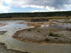
Sentinel Meadows & Queen's Laundry
Madison, Yellowstone National Park
36.1 miles NEThe hike to Sentinel Meadows and Queens Laundry gives you a level trail with wide open meadows, hot springs, ponds, birds, and a little bit of Yellowstone National Park history. The trail can be done...
Hike
Herbert Idaho Ghost Town
Ririe, Idaho
36.1 miles SWCLOSED. Private property marked NO TRESPASSING. Herbert is a small ghost town that was operated until the 40s, but with the invention of the automobile, it was much more convenient to live in Rexburg...
Hike 4.8 mi
Aldous Lake and Hancock Lake
Kilgore, Idaho
36.7 miles NWA pair of alpine lakes near Kilgore, Idaho. Good road all the way to the trailhead. Easy to moderate 1.5mi hike to the first lake (Aldous) and another mile of moderate hiking to Hancock. Beautiful...
Backpack, Camp, Hike, Horseback, Swim 0.6-2.2 mi
Fish Creek Area
Ririe, Idaho
36.9 miles SFish Creek is a network of mountain bike trails up in the Big Hole Mountains. The trails are easily accessed from either the Ririe or Rexburg side of the range. The trail system is set up much...
Hike, Mountain Bike 4.8 mi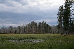
Riddle Lake Hike
Grant Village, Yellowstone National Park
37.5 miles ERiddle Lake hike is a 5 mile roundtrip hike. Riddle Lake is an alluring body of water with a sandy beach. The hiker gets the best of both worlds on this hike. Impressive pine and mountain views,...
Hike 0.1-7.3 mi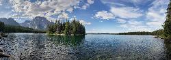
Leigh Lake
Alta, Wyoming
37.5 miles SEEnjoy the grandeur of Grand Teton National Park just a little ways off the beaten path. Leigh Lake rests underneath the majestic Mount Moran. The waters of Leigh Lake flow almost directly into String...
Backpack, Canoe, Hike, Kayak 3.6 mi
String Lake
Alta, Wyoming
37.7 miles SEString Lake is a shallow lake that connects Leigh Lake and Jenny Lake at the base of Mount St. John and Rockchuck Peak. From the lakeshore, you can also take in beautiful views of Teewinot and Mt....
Canoe, Hike, Kayak, Swim 10.5-16.2 mi
Paintbrush Canyon
Alta, Wyoming
37.8 miles SEBeautiful trail along String Lake, Leigh Lake, and Lake Solitude. For even more solitude, scramble up the rocks to Micah Lake for a beautiful view and even fewer people. You won't find...
Backpack, Hike 0.3-5.1 mi
Jenny Lake Trail
Jackson Hole, Wyoming
37.9 miles SEOne of the most popular trails to visit in Grand Teton is the Jenny Lake Trail. The Jenny Lake Trail, located near Moose, Wyoming, is an easy trail that loops around the lake. Along with the sheer...
Hike 1.7 mi
Buckskin Morgan Ridge
Ririe, Idaho
38.6 miles SWGoing up is a little tough because of the rocks, but once you clear the top it is a twisty down hill portion [until] you get to a fenced road. From there you can turn around or keep going strait...
Hike, Mountain Bike 1.1 mi
Hidden Vista / Pine Loop
Ririe, Idaho
38.6 miles SWYou'll find the Hidden Vista trailhead on the South End of the Buckskin Morgan parking lot about a mile past Y Junction. This is a short trail with a little up and a little down for just under a...
Hike, Mountain Bike 4.9 mi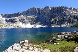
Amphitheater Lake
Alta, Wyoming
38.7 miles SEBackpack and Hike near Alta, Wyoming
Backpack, Hike 0.8 mi
Harlequin Lake Trail
Madison, Yellowstone National Park
38.8 miles NEHarlequin Lake Trail is a beautiful short hike that can be taken in under an hour. This scenic hike is easy and family friendly, making it the perfect activity to add to any Yellowstone visit....
Hike
Burns Canyon
Ririe, Idaho
39.1 miles SHike and Mountain Bike near Ririe, Idaho
Hike, Mountain Bike
Poison Flats
Ririe, Idaho
39.2 miles SWHike near Ririe, Idaho
Hike 3.8 mi
Kelly Mountain Trail
Ririe, Idaho
39.2 miles SWKelly Canyon Trail is a moderate, uphill trail that can be used by hikers, mountain bikers, and ATV riders. The trail features views of hills, mountains, trees, wildflowers, and some wildlife. Dogs...
Cross-country Ski, Hike, Mountain Bike, Snowshoe


