


Map of 179 Mountain Bike Trails in Idaho
first prev 1 2 3 4 5 6 7 8 9 next lastShowing Mountain Bike Trails in Idaho, USA City, Zip, or Address

Burns Canyon
Ririe, Idaho
15.3 miles E of Ririe, IdahoHike and Mountain Bike near Ririe, Idaho
Hike, Mountain Bike 17.5 mi
Tear Drop Lake
Ashton, Idaho
19.1 miles NE of Ashton, IdahoNestled in the Targhee National Forest just off of Ashton's Fish Creek Road, this tear drop shaped lake is a family adventure waiting to happen. The lake isn't very big but it is teeming with...
Camp, Canoe, Hike, Kayak, Mountain Bike, Swim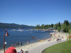
Mccall Area
McCall, Idaho
10.4 miles NE of McCall, IdahoMcCall is a beautiful resort town located in western Idaho, two hours north of Boise. It's feautures a multitude of activity of activities in both the Winter and Summer months, including:...
Backpack, Camp, Canoe, Cross-country Ski, Hike, Kayak, Mountain Bike, Sled, Snowshoe, Swim 0.2-9.7 mi
City Creek
Pocatello, Idaho
1.3 miles S of Pocatello, IdahoThe City Creek Management Area (CCMA) Trail System is a vast network of trails maintained by the City of Pocatello. There are trails to go up and others to come down. Most trails come back to the...
Hike, Horseback, Mountain Bike 3.8 mi
Kelly Mountain Trail
Ririe, Idaho
8.2 miles E of Ririe, IdahoKelly Canyon Trail is a moderate, uphill trail that can be used by hikers, mountain bikers, and ATV riders. The trail features views of hills, mountains, trees, wildflowers, and some wildlife. Dogs...
Cross-country Ski, Hike, Mountain Bike, Snowshoe 5.7-8.1 mi
Space Cruz
Ririe, Idaho
9.0 miles E of Ririe, IdahoCLOSED. This land is owned and managed by the US Forest Service and the upper portions of this route are not designated for use. As of July 2024, being caught mountain biking on PINE LOOP or THE...
Cross-country Ski, Mountain Bike 0.6-5.5 mi
Old Ranger
Ririe, Idaho
15.2 miles E of Ririe, IdahoOn the South end of the Big Hole mountains just above the Snake River is a grueling yet diverse section of single-track on Forest Service Trail 287 called Old Ranger. Because of the...
Mountain Bike 1.7 mi
Randy's Cow Trail / Ken's Corner
Ririe, Idaho
7.5 miles E of Ririe, IdahoThis trail descends from the fence corner at the West end of Batman and continues down to Lyon's Creek Parking just off Lyon's road. The top of this trail is only a couple hundred yards from...
Mountain Bike 0.6-4.7 mi
Harriman State Park
Island Park, Idaho
8.3 miles SW of Island Park, IdahoHarriman State Park is found 38 miles from Yellowstone along Henry's Fork. This 11,000-acre wildlife refuge is open year round for most activities. In addition to having beautiful scenery and...
Cross-country Ski, Hike, Horseback, Mountain Bike, Snowshoe 5.6-8.3 mi
Palisades Creek Trail / Lakes and Waterfall Canyon
Irwin, Idaho
4.4 miles E of Irwin, IdahoPalisades Creek Trail is located about 50 miles southeast of Idaho Falls and about 60 miles west of Jackson Hole WY in Swan Valley Idaho. The four mile hike up to lower Palisades Lake or the 6.2 mile...
Backpack, Camp, Hike, Horseback, Mountain Bike 0.5-3.5 mi
Webster's Dam
Ririe, Idaho
9.8 miles NE of Ririe, IdahoAlso known as Manmade Falls or the Woodmansee Dam, Webster Dam is an abandoned dam located deep in Moody Creek canyon, the dam was abandoned when sediment built up behind the dam which then...
Camp, Hike, Mountain Bike 29.6 mi
Ashton to Tetonia Trail
Ashton, Idaho
0.7 miles NE of Ashton, IdahoThe Idaho Department of Parks and Recreation undertook the project to transform the old Teton Valley Branch of the Union Pacific Railroad from Ashton to Tetonia into a trail for bikes, ATVs, and...
Mountain Bike 0.1-0.5 mi
Eagle Park
Rexburg, Idaho
0.9 miles N of Rexburg, IdahoEagle Park is a little urban oasis. Once you drive in to this cottonwood forest along the river, you may forget that you're still inside Rexburg city limits. You can camp, picnic, throw rocks in...
Camp, Hike, Mountain Bike, Sled 0.6 mi
Packsaddle Lake
Tetonia, Idaho
9.3 miles W of Tetonia, IdahoPacksaddle is one of the less well known lakes/trails in the area. If you've got a good offroad vehicle, you can probably make it all the way to the end of the road, otherwise, it's just an...
Dive, Hike, Mountain Bike, Snowshoe, Swim
Central Foothills
Boise, Idaho
1.3 miles NE of Boise, IdahoFrom foothills to mountain tops, Idaho's wilderness offers some of the best hiking in the country. With over 19,000 miles of trails, hikers can find everything from paved recreational trails...
Hike, Mountain Bike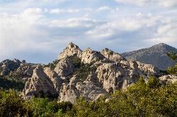
City of Rocks National Reserve
Malta, Idaho
23.3 miles SW of Malta, IdahoThe City of Rocks, or "The City" as locals call it, is one of the best places in the country to go rock climbing. Throughout the valley granite spires dominate the skyline, reaching...
Camp, Hike, Horseback, Mountain Bike, Rock Climb 3.2-47.0 mi
Yellowstone Branch Line Trail
Ashton, Idaho
7.6 miles NE of Ashton, IdahoYellowstone branch line trail runs from Warm River to the Montana border totaling 39 miles. There are a few places to jump on and off the trail as well as a few smaller trails that branch off of this...
Backpack, Cross-country Ski, Hike, Horseback, Mountain Bike 13.2-13.5 mi
Bear Creek Hot Springs
Irwin, Idaho
9.8 miles S of Irwin, IdahoBear Creek Hot Springs is a 15 mile out and back trail with a hot spring at the end. The trail is not well marked and is only recommended for very experienced outdoorsmen and primarily used for...
Backpack, Camp, Hike, Horseback, Hot Springs, Mountain Bike 2.7 mi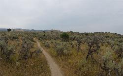
Sidewinder Trail
Ririe, Idaho
6.5 miles E of Ririe, IdahoSidewinder's claim to fame is that it's on a South facing hill just above the Snake River. That means that when all the other trails in the Kelly Canyon Trail network are covered with snow...
Mountain Bike 1.7 mi
Buckskin Morgan Ridge
Ririe, Idaho
9.0 miles E of Ririe, IdahoCLOSED. This land is owned and managed by the US Forest Service and is not designated for use. As of July 2024, being caught mountain biking on this trail could recieve up to a $5000 fine and a...
Hike, Mountain Bike


