


142 Mountain Bike Trails near Pete's Rock
first prev 1 2 3 4 5 6 7 8 next lastShowing Mountain Bike Trails within 50 miles Distance miles of 5800 Wasatch Blvd E, Salt Lake City, UT 84121, USA City, Zip, or Address

Ferguson Canyon
Cottonwood Heights, Utah
3.0 miles SA popular climbing destination tucked between Big and Little Cottonwood Canyons, where you can hike into a shaded canyon with a stream or push on to a rocky summit for sweeping views.
Hike, Mountain Bike, Rock Climb
Storm Mountain
Salt Lake City, Utah
3.9 miles SEA compact Wasatch peak just 3 miles up Big Cottonwood Canyon, with rock climbing routes, hiking, biking, and Big Cottonwood Creek running right alongside the day-use area.
Hike, Mountain Bike, Rock Climb 3.2 mi

Little Cottonwood Pipeline Trail
Sandy, Utah
5.8 miles SA single-track trail starting at the mouth of Little Cottonwood Canyon that stays smooth for the first mile, then gets rocky and steep — ending across a creek from historic ruins after 3.5 miles.
Mountain Bike
Mill Creek Pipeline
Salt Lake City, Utah
5.9 miles NEA connector trail system feeding into Mill Creek Pipeline near Salt Lake City — about 6.5 miles in, a sign marks the Rattlesnake downhill, which drops you near the toll booth.
Mountain Bike 1.1-4.7 mi
Bells Canyon
Sandy, Utah
6.1 miles SA 4.5-mile moderate hike up to a canyon waterfall through gorgeous fall foliage, meadows, wildflowers, and a creekside trail — the last 1.2 miles involve serious climbing over large rocks.
Backpack, Hike, Mountain Bike, Snowshoe
Mt. Wire
Salt Lake City, Utah
6.8 miles NA steep, loose singletrack away from the crowds on Salt Lake City's Mt. Wire, with a roller-coaster pipeline section and a choice of returning on the Bonneville Shoreline or heading up Emigration Canyon.
Mountain Bike 0.4 mi
Hidden Valley Park trail
Sandy, Utah
7.8 miles SA hidden shallow valley of grass, sandstone cliffs, and Navajo Sandstone domes just south of Moab — loop options total about one mile, but bring water because it gets hot.
Hike, Mountain Bike
Bonneville Shoreline Trail - Northern Salt Lake City
Salt Lake City, Utah
7.9 miles NRiding the old Lake Bonneville shoreline along the Wasatch Mountains, this trail offers a great aerobic workout, rideable winters, and sweeping views of Salt Lake City.
Mountain Bike
Bobsled Trail
Salt Lake City, Utah
9.0 miles NA fast, technical downhill old-creekbed trail in Salt Lake City with bank turns, major jumps, and plenty of air — for advanced riders only, and going uphill isn't an option.
Mountain Bike 0.2 mi
Orson Smith trail
Draper, Utah
9.0 miles SA short Draper foothills trail leading to a popular suspension bridge completed in 2015 at Bear Canyon — connecting to the Bonneville Shoreline Trail and open to hikers, bikers, and bird watchers.
Hike, Mountain Bike 0.8 mi
Bear Canyon Suspension Bridge
Draper, Utah
9.2 miles SA 4.5-mile moderate hike in Draper connecting to a 185-foot suspension bridge over Bear Canyon, with sweeping Salt Lake Valley views and dozens of additional trails branching off nearby.
Hike, Mountain Bike
White Pine Lake
Sandy, Utah
10.2 miles SEA canyon that ski resort lobbyists fought to keep out of wilderness, now open to hikers and rare mountain bikers — hike in and discover why everyone has been arguing over White Pine Canyon.
Hike, Mountain Bike 4.7 mi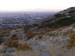
Bonneville Shoreline Trail
Salt Lake City, Utah
10.2 miles NA multi-use trail stretching from North Salt Lake to Parley's Canyon that follows the ancient shoreline of Lake Bonneville — perfect for hiking, biking, and trail running.
Hike, Mountain Bike 0.6 mi
Bst To Equestrian Center Loop
Draper, Utah
10.4 miles SA 10-mile intermediate singletrack loop in Draper connecting the Bonneville Shoreline Trail and Equestrian Center with 417 feet of elevation along varied terrain.
Hike, Mountain Bike 1.6 mi
Corner Canyon Trail
Draper, Utah
10.4 miles SA go-to mountain biking area in South Salt Lake mixing beginner training trails in Little Valley with big table tops and wall rides in Maple Hollow.
Backpack, Hike, Mountain Bike
Mormon Flats
Salt Lake City, Utah
10.6 miles NEA historic pioneer-trail singletrack through surreal, quiet forest with a log crossing, river crossings, and fast flat-out sections — ending at the top of Little Mountain by mountain dell reservoir.
Mountain Bike 1.2 mi
Ghost Falls Trail
Sandy, Utah
10.9 miles SA family-friendly hike in Corner Canyon that winds through sandy rocky slopes and dry creek beds to the Ghost Falls loop, with helpful trail signs at the confusing intersections.
Hike, Mountain Bike, Snowshoe 0.2-1.8 mi
Lone Peak
Draper, Utah
11.0 miles SOne of the Wasatch Front's taller peaks at over 11,000 feet, Lone Peak offers five different trailhead approaches, a 9-mile average round trip, rugged canyon terrain, and stunning Salt Lake valley views.
Hike, Mountain Bike, Rock Climb 1.7 mi
Jacob's Ladder Trail
Sandy, Utah
11.0 miles SJacob's Ladder is the steep, relentless local favorite for climbing into the Lone Peak Wilderness above Draper, Utah — and a legendary technical descent.
Hike, Mountain Bike 0.6 mi
Potato Hill Trail
Draper, Utah
11.6 miles SA short, paved trail system in Draper that connects Potato Hill to the Bonneville Shoreline Trail — combine with Red Potato and Lexie and Ethan trails for a 3-mile loop with smooth climbing.
Hike, Mountain Bike


