


American River Confluence
Auburn, California

| GPS: |
38°54'52.6"N 121°2'8.2"W Maps | Directions |
| State: | California |
Waterfalls Rocks State Park
Hike, Horseback, Kayak, Rock Climb, Swim, and Whitewater
The Confluence — where the North and Middle Forks of the American River meet, just below the soaring Foresthill Bridge (the highest bridge in California) — is the beating heart of the Auburn State Recreation Area and one of the Sierra foothills' most beloved places to cool off. Clear green-blue water, sun-warmed rocks, and sandy pocket beaches make it a summer magnet for swimmers, rafters, and sunbathers just minutes from downtown Auburn.
This is a true recreation hub. Swimmers wade and paddle the calmer pools along the bank; whitewater rafters and kayakers use the Confluence as a classic put-in and take-out for runs on both forks; and hikers and runners fan out on the surrounding trails, including the historic No Hands Bridge and the Western States Trail. Gold-rush history runs deep here — this stretch was heavily mined in the 1800s.
The area is managed by California State Parks; a per-vehicle day-use fee applies at the staffed lots (bring cash), and it gets busy and hot on summer weekends, so arrive early. Watch the current, which can run swift and cold during spring snowmelt, and keep a close eye on kids near the moving water.
Bring water shoes, sun protection, and plenty of drinking water, and pack out everything you bring to help protect this heavily loved river.
More Information
North Fork Falls Waterfall And Swimming Hole At Emigrant Gap
Short hike from the North Fork Campground to the North Fork Falls two-tier waterfall and swimming hole at Emigrant Gap in the Lake Tahoe National Forest
https://inspiredimperfection.com/adventures/north-fork-falls-swimming-hole-emigrant-gap/swimmingholes.org: CALIFORNIA SWIMMING HOLES
THE web site for beautiful, natural places for a cool dip or hot soak.
https://www.swimmingholes.org/ca.htmlBe courteous, informed, and prepared. Read trailhead guidelines, stay on the trail, and don't feed the wildlife.
Read More- Plan Ahead and Prepare
- Travel & camp on durable surfaces
- Dispose of waste properly
- Leave what you find
- Minimize campfire impacts
- Respect wildlife
- Be considerate of other visitors
Directions
From Auburn, California
- Head southwest on Market St (486 ft)
- Turn right onto Franklin StPass by Walgreens (on the left in 0.9 mi)(2.0 mi)
- Turn right onto Francisco St (0.2 mi)
- Turn left at the 2nd cross street onto Polk St (0.2 mi)
- Turn right onto Beach St (118 ft)
From Sacramento, take I-80 east to Exit 119 at Auburn. Take RT 49 south, then:
Courtesy of swimmingholes.org


Other Rock Climbing Walls, Swimming Holes, Hiking Trails, Horseback Trails, Kayaking Areas, and Whitewater Rapids Nearby

Lake Clementine Trail Loop
Auburn, California
0.1 miles NFour connected trails loop around Lake Clementine on the North Fork American River — wheelchair accessible, pet friendly, and great for fishing, camping, and family summer outings.
Camp, Canoe, Hike, Kayak, Mountain Bike, Swim 5.6 mi
Quarry Trail
Cool, California
0.6 miles EA riverside hike along an old limestone railway line to a dramatic amphitheater quarry — wildflowers peak April through June, and the historic railway story (scrap metal for WWII) adds a fascinating layer.
Hike
Rocklin Quarry
Rocklin, California
13.9 miles SWA historic granite quarry behind Rocklin's city office building — open since 1864, supplier of Capitol stone, and best viewed from the second-floor exterior stairwell landing.
Rock Climb 0.1 mi
Edwards Crossing
Nevada City, California
28.8 miles NDeep blue water, rock cliffs, and a sandy beach on the Yuba River — with a half-mile walk from the parking lot and cliff jumping spots up to 20 feet deep.
Hike, Swim
North Fork Falls
Colfax, California
30.6 miles NEClear water, cliff-jumping pools, and waterfalls at Sierra Nevada's North Fork Falls — a summer hike to two deep pools with 10-to-25-foot cliffs ready for leaping.
Camp, Hike, Swim
Sutter National Wildlife Refuge
Meridian, California
40.5 miles WA 2,600-acre Sacramento Valley wildlife refuge 50 miles north of Sacramento, managing wetland impoundments and riparian habitat as critical wintering grounds for waterfowl.
Hike
Heath Falls Overlook Trail
Truckee, California
41.8 miles NEHike and Swim near Truckee, California
Hike, Swim
Palisades Creek Trail
Truckee, California
41.8 miles NEA difficult Sierra Nevada trail past Palisade Falls — one of the tallest on the American River — with views of Devils Peak, alpine lakes, and 2,000 feet of elevation gain.
Hike, Swim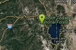
Tahoe Area
Olympic Valley, California
45.5 miles NESwim near Olympic Valley, California
Swim
Shirley Canyon
Olympic Valley, California
46.5 miles NEHike near Olympic Valley, California
Hike 4.1 mi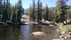
Shirley Lake Canyon Trail
Olympic Valley, California
46.8 miles NEA 2.5-mile hike from Squaw Valley Village past streams and waterfalls to a pure Sierra lake — rocky near the top, with a free gondola ride back down from High Camp as a reward.
Hike, Swim
Cosumnes River Preserve
Galt, California
49.9 miles SWA 45,859-acre wildlife habitat and agricultural preserve centered on the Cosumnes River near Galt — supporting Pacific Flyway migrating birds and varied riparian habitats.
Canoe, HikeNearby Campsites
Lake Clementine Trail Loop
Auburn, California
0.1 miles NFour connected trails loop around Lake Clementine on the North Fork American River — wheelchair accessible, pet friendly, and great for fishing, camping, and family summer outings.
Camp, Canoe, Hike, Kayak, Mountain Bike, Swim
North Fork Falls
Colfax, California
30.6 miles NEClear water, cliff-jumping pools, and waterfalls at Sierra Nevada's North Fork Falls — a summer hike to two deep pools with 10-to-25-foot cliffs ready for leaping.
Camp, Hike, Swim


