


255 Things to do near Conant Creek Pegram Truss Railroad Bridge
first prev 1 2 3 4 5 6 7 8 9 10 next lastShowing results within 50 miles Distance miles of 3968 E 1000 N, Ashton, ID 83420, USA City, Zip, or Address
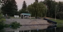
St. Anthony Sandbar
Saint Anthony, Idaho
16.0 miles WCLOSED. //// Sand Bar Update //// ***As of 27 June 2019 *** The Sand Bar is still closed to ALL swimming, please do not cross the boundary line. We are closely monitoring the river flows...
Dive, Swim
Horseshoe Lake
Ashton, Idaho
16.2 miles NEHorseshoe Lake is hidden back in the Targhee National Forest. It's a beautiful lake with plenty of lily pads. The road to get there is well maintained and there are many options for pull-outs...
Camp, Canoe, Dive, Swim
Wright Creek Trail
Tetonia, Idaho
16.6 miles SOpen to MTB, horseback riding, snowshoeing, and hiking. source: fs.usda.gov
Mountain BikeHenry's Fork Green Way (St. Anthony Green Belt)
Saint Anthony, Idaho
16.7 miles WThis is a great walk along the river. While it is nestled right next to the highway, the closeness and beauty of the river flowing on the other side of the trail more than make up for it. Halfway...
Hike
Flat Canyon Trail
Island Park, Idaho
17.0 miles NENon-motorized use. souce: fs.usda.gov
Mountain Bike
Marshall's
Saint Anthony, Idaho
17.4 miles SWMarshall's Wave is located on the North Fork of the Teton River, where the Teton River splits into the north and south forks. The wave is created by a headgate and is best at flows above 600...
Kayak 0.6 mi
Packsaddle Lake
Tetonia, Idaho
17.5 miles SPacksaddle is one of the less well known lakes/trails in the area. If you've got a good offroad vehicle, you can probably make it all the way to the end of the road, otherwise, it's just an...
Dive, Hike, Mountain Bike, Snowshoe, Swim
Sand Creek Frenzy
Ashton, Idaho
18.0 miles NWThere are some woods back there and it is secluded. There are many places you can play just watch out for campers.
Paintball 17.5 mi
Tear Drop Lake
Ashton, Idaho
18.1 miles NENestled in the Targhee National Forest just off of Ashton's Fish Creek Road, this tear drop shaped lake is a family adventure waiting to happen. The lake isn't very big but it is teeming with...
Camp, Canoe, Hike, Kayak, Mountain Bike, Swim 14.8-30.2 mi
Mr. Bubbles Hot Spring
Old Faithful, Yellowstone National Park
18.1 miles NEMr. Bubbles is one of the few places you can actually soak in the thermal waters of Yellowstone National Park. The Bechler area of Yellowstone is one of the best kept secrets of the otherwise densely...
Hike, Hot Springs
Sucky Courtney's
Saint Anthony, Idaho
18.6 miles SWKayaker playing in Marshall's Wave near Rexburg, Idaho. The wave is located on the North Fork of the Teton River and is best at flows above 600 cfs. The wave is good for beginners. It has a...
Kayak
Basalt Bluff / Steve's Rock
Teton, Idaho
19.1 miles SWDon't go anywhere marked No Trespassing and Beware of the Attack Bees at the top of the cliffs and the Stinging Nettle at the bottom. About a mile north of Loon Lake/Wentworth Springs Road...
Rock Climb
Probation And Burg Bumper
Tetonia, Idaho
19.9 miles SThe Probation part of the trail is the steepest downhill in the area. Has multiple bridges and log jumps in the short mile down. The Burg portion of the trail is uphill with some...
Mountain Bike
Cave Falls of Yellowstone
Ashton, Idaho
20.0 miles NEThis campgrond is situated on the banks of Fall River in Wyoming along the south border of Yellowstone National Park. Cave Falls Campground has 23 single site units and a terrific area for...
Camp, Hike
St. Anthony Sand Dunes
Saint Anthony, Idaho
20.6 miles WBest known for their offroad riding conditions, the St. Anthony Sand Dunes provide a sledding experience unlike any other. These mountains of sand are fun for sliding down in the summer but during...
Sled 0.6-4.7 mi
Harriman State Park
Island Park, Idaho
20.9 miles NHarriman State Park is found 38 miles from Yellowstone along Henry's Fork. This 11,000-acre wildlife refuge is open year round for most activities. In addition to having beautiful scenery and...
Cross-country Ski, Hike, Horseback, Mountain Bike, Snowshoe
Sharks Belly
Driggs, Idaho
21.2 miles STrail system can start from Channel lock or Bovine. Channel Lock is an easier climb than Bovine. This description and mileage starts at the Channel Lock trail, forest service boundary marker. Take...
Mountain Bike
Channel Lock
Driggs, Idaho
21.2 miles STrail is a little over 1 mile uphill. Recommended route up to access the larger Horseshoe canyon trail system. Makes a nice downhill with twists. Gets its name from the deep ruts made from cows....
Mountain Bike
Southbound
Driggs, Idaho
21.2 miles STrail starts by going up the Channel lock trail. At the top of Channel Lock go right onto the Southbound trail. Trail will loop back to Channel lock which you take back to your car. Trail is...
Mountain Bike
Horseshoe Canyon
Tetonia, Idaho
21.3 miles SHorseshoe Canyon is one of the closest trail systems to the town of Driggs, Idaho. This network doesn't have a ton of climbing or descending, but the smooth, swooping singletrack with a...
Mountain Bike


