


163 Things to do near Heart Lake Trail
first prev 1 2 3 4 5 6 7 8 9 next lastShowing results within 50 miles Distance miles of Continental Divide Trail, Yellowstone National Park, WY 82190, USA City, Zip, or Address

Riverside Bike Trail
West Yellowstone, Montana
34.1 miles NWJust inside Yellowstone's West Entrance is a short and stunning mountain bike trail that shouldn't be missed. Riverside Bike Trail is a gravel and dirt trail that leads through the forest to...
16.3 mi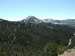
Mount Washburn Spur Trail
Canyon Village, Yellowstone National Park
34.1 miles NWashburn Spur Trail is an exciting 8-mile trail connecting the peak of Mount Washburn to Seven Mile Hole Trail near Canyon Village. Hikers typically hike the trail starting at Mount Washburn and...
Hike 4.4 mi
Chittenden Road - Mount Washburn Trail
Canyon Village, Yellowstone National Park
34.2 miles NHiking Mount Washburn via Chittenden Road is the shortest and easiest route to the top. The trail was once a service road and is now a clear well packed trail with a steady, gradual incline. The...
Hike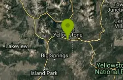
Rendezvous Loop
West Yellowstone, Montana
34.4 miles NWGentle rolling hills that wind though tall stands of lodgepole pine and open meadows. Easy ride with great potential for speed.
Mountain Bike
Mt. Moran
Alta, Wyoming
34.5 miles SMount Moran (12,610 feet (3,840 m)) is a mountain in Grand Teton National Park of western Wyoming, USA. The mountain is named for Thomas Moran, an American western frontier landscape artist....
Hike

Porcupine Creek
Ashton, Idaho
34.7 miles SWPorcupine Creek is a hunting, fishing, camping, and swimming spot near Ashton, Idaho in Fremont County within Targhee National Forest. It's surrounded by forests, meadows, and a creek...
Camp, Swim
Big Springs
Island Park, Idaho
34.8 miles WThere's also a great little walking trail along the river with placards that tell about the ecosystem and history of the area. There's about a 1/2 mile that's paved and then a 1/2 mile...
Camp, Hike 2.8 mi
Mount Washburn Bike Trail
Devils Den, Wyoming
35.8 miles NMount Washburn Bike Trail follows Chittenden Service Road for 2.5 miles to the top of Mount Washburn. This steep climb up the mountain provides a challenging elevation gain of 1500 feet. Mount...
Mountain Bike
The Pit
Ashton, Idaho
35.9 miles WThis location is great because there is no one around only locals know of this area and you can shoot anything out there. Watch out for target shooters there! Also stay away from the main road.
Airsoft, Paintball 0.3-0.6 mi
Bear Gulch
Ashton, Idaho
36.0 miles WBear Gulch is an abandoned ski hill out of operation since 1969. While the vegetation is beginning to take over, there's still some great sledding to be had. It's just far enough into the...
Camp, Cross-country Ski, Hike, Sled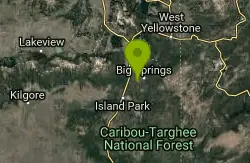
Boundary Trail
Island Park, Idaho
36.2 miles WBoundary Trail, (Trail #272 and #244) is a 37 mile loop trail that allows stock travel, mountain bike, motorcycle and ATV travel. This trail can be reached by several trailheads,...
Mountain Bike
Falls River, Lower Run
Ashton, Idaho
36.5 miles SWFall River rises on the Madison and Pitchstone plateaus in the southwest corner of Yellowstone National Park, Wyoming and flows approximately 64 miles (103 km) to its confluence with the Henrys Fork...
Whitewater 0.1-7.3 mi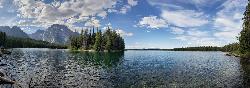
Leigh Lake
Alta, Wyoming
37.1 miles SEnjoy the grandeur of Grand Teton National Park just a little ways off the beaten path. Leigh Lake rests underneath the majestic Mount Moran. The waters of Leigh Lake flow almost directly into String...
Backpack, Canoe, Hike, Kayak
Mesa Falls
Ashton, Idaho
37.2 miles WUpper Mesa Falls, aka Big Falls, is an absolutely awesome waterfall on the Henrys Fork of the Snake River. The falls drop 114 ft. and measure 300 ft. across. To get to the falls from the parking lot...
Cross-country Ski, Hike, Kayak
Bitch Creek Trestle
Tetonia, Idaho
37.3 miles SWAs part of the Rails to Trails project, this old railroad bridge has been transformed into a very safe little viewing experience for the whole family. You can drive right up to the bridge where...
Hike 3.6 mi
String Lake
Alta, Wyoming
37.4 miles SString Lake is a shallow lake that connects Leigh Lake and Jenny Lake at the base of Mount St. John and Rockchuck Peak. From the lakeshore, you can also take in beautiful views of Teewinot and Mt....
Canoe, Hike, Kayak, Swim 10.5-16.2 mi
Paintbrush Canyon
Alta, Wyoming
37.4 miles SBeautiful trail along String Lake, Leigh Lake, and Lake Solitude. For even more solitude, scramble up the rocks to Micah Lake for a beautiful view and even fewer people. You won't find...
Backpack, Hike
Warm River Campground
Ashton, Idaho
37.8 miles WWarm River Campground is located nine miles northeast of Ashton, Idaho, along the slow-moving Warm River at an elevation of 5,200 feet. Willows line the riverbanks and pine trees offer partial...
Camp 3.2-47.0 mi
Yellowstone Branch Line Trail
Ashton, Idaho
37.9 miles WYellowstone branch line trail runs from Warm River to the Montana border totaling 39 miles. There are a few places to jump on and off the trail as well as a few smaller trails that branch off of this...
Backpack, Cross-country Ski, Hike, Horseback, Mountain Bike 0.9 mi
Buffalo River Campground
Island Park, Idaho
38.5 miles WThe float here is nice and easy. It's a great early season float. Later in the season the shallow spots will force you to walk a good chunk of the float. The water is super clear and often pretty...
Camp, Canoe, Kayak, Swim


