


216 Things to do near Saint Anthony, Idaho
first prev 1 2 3 4 5 6 7 8 9 10 next lastShowing results within 50 miles Distance miles of St Anthony, ID 83445, USA City, Zip, or Address

Probation And Burg Bumper
Tetonia, Idaho
24.2 miles SEThe Probation part of the trail is the steepest downhill in the area. Has multiple bridges and log jumps in the short mile down. The Burg portion of the trail is uphill with some...
Mountain Bike
Thousand Springs Trail
Driggs, Idaho
24.2 miles SEThe Thousand Springs trail begins at Moody Swamp trailhead and ends at Jct Prospect Peak Trail. source: fs.usda.gov Courtesy of Singletracks.com
Mountain Bike
Porcupine Creek
Ashton, Idaho
24.4 miles EPorcupine Creek is a hunting, fishing, camping, and swimming spot near Ashton, Idaho in Fremont County within Targhee National Forest. It's surrounded by forests, meadows, and a creek...
Camp, Swim 4.3 mi
Leaning Fir #169
Ririe, Idaho
24.7 miles SMountain Bike near Ririe, Idaho
Mountain Bike 2.7 mi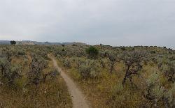
Sidewinder Trail
Ririe, Idaho
24.7 miles SSidewinder's claim to fame is that it's on a South facing hill just above the Snake River. That means that when all the other trails in the Kelly Canyon Trail network are covered with snow...
Mountain Bike 3.8 mi
Stinking Springs
Ririe, Idaho
24.7 miles SStinking Springs is a great early to late season trail. Being at the edge of the Big Hole range, it gets spring earlier and winter later than other trails in the range. It's closed from December...
Hike, Mountain Bike
Wolverine Creek Trail
Ririe, Idaho
25.3 miles SThe Wolverine Creek Trail is a doubletrack trail in Ririe, Idaho. It begins at South Fork Road and ends at Wolverine trailhead. It is commonly used by dirt bikes and four wheelers. This trail is...
Mountain Bike 0.3 mi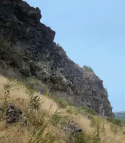
Pointless Crag
Ririe, Idaho
25.3 miles SNO MORE BOLTING as of 5/2012 requested by the Bureau of Land Management. The BLM has asked us NOT to park on the road below the cliff. Please use the obvious parking area next to the river...
Rock Climb
North Mahogany Trail #220
Tetonia, Idaho
25.5 miles SEhe N. Mahogany Trail is open to Motorbikes, Mountain bikes, Horses, and Hikers. Motorbikes and Horseback riders are the most common visitors, but the trail is becoming increasingly...
Mountain Bike
Wolf Flats Recreation Area
Ririe, Idaho
25.6 miles SWolf Flats is a completely free, dispersed, undeveloped camping area with 25 locations to camp. Some areas are large enough to accommodate groups of 50 people.
Camp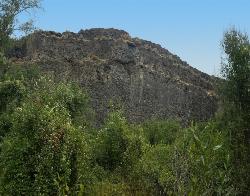
South Park
Ririe, Idaho
25.7 miles SRock Climb near Ririe, Idaho
Rock Climb
Horseshoe Canyon
Tetonia, Idaho
25.7 miles SEHorseshoe Canyon is one of the closest trail systems to the town of Driggs, Idaho. This network doesn't have a ton of climbing or descending, but the smooth, swooping singletrack with a...
Mountain Bike
Horseshoe Trails
Driggs, Idaho
25.8 miles SEMountain Bike near Driggs, Idaho
Mountain Bike
Bovine
Driggs, Idaho
25.8 miles SEBovine trail is part of a larger system. You can use it to access more trails or make it your end destination from other trailheads. It is a steep climb but returns the favor with a fast downhill....
Mountain Bike

Channel Lock
Driggs, Idaho
26.0 miles SETrail is a little over 1 mile uphill. Recommended route up to access the larger Horseshoe canyon trail system. Makes a nice downhill with twists. Gets its name from the deep ruts made from cows....
Mountain Bike
Sharks Belly
Driggs, Idaho
26.1 miles SETrail system can start from Channel lock or Bovine. Channel Lock is an easier climb than Bovine. This description and mileage starts at the Channel Lock trail, forest service boundary marker. Take...
Mountain Bike
Southbound
Driggs, Idaho
26.1 miles SETrail starts by going up the Channel lock trail. At the top of Channel Lock go right onto the Southbound trail. Trail will loop back to Channel lock which you take back to your car. Trail is...
Mountain Bike
The Arcane
Ririe, Idaho
26.3 miles SRock Climb near Ririe, Idaho
Rock Climb
Bitch Creek Trestle
Tetonia, Idaho
26.4 miles EAs part of the Rails to Trails project, this old railroad bridge has been transformed into a very safe little viewing experience for the whole family. You can drive right up to the bridge where...
Hike 2.1-2.3 mi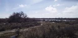
Market Lake Wildlife Management Area
Roberts, Idaho
26.5 miles SWMallards, Canada geese, canvasbacks, cinnamon and green-winged teal, northern shovelers and ruddy ducks are common waterfowl species nesting and raising broods on the WMA. Several thousand...
Hike, Horseback


