


227 Things to do near Sugar City, Idaho
first prev 2 3 4 5 6 7 8 9 10 11 next lastShowing results within 50 miles Distance miles of Sugar City, ID, USA City, Zip, or Address

Pine Butte / The Caldera
St. Anthony, Idaho
27.3 miles NThis is about as close to an oasis as you can get in the deserts of Idaho. It's an old volcano in the middle of the sagebrush desert. As soon as you start down the path, you can feel the air...
Camp, Hike, Horseback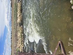
Double Tap wave feature
Idaho Falls, Idaho
27.3 miles SWIt's a fun little double feature in an irrigation canal the first is a open elevation control dam that throws a nice wave and foam pile off of it great for freestyle kayaking then about 30 yards...
Canoe, Kayak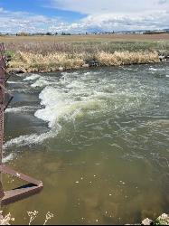
The Junk Field Wave
Idaho Falls, Idaho
27.3 miles SWKayak near Idaho Falls, Idaho
Kayak 3.2-47.0 mi

Yellowstone Branch Line Trail
Ashton, Idaho
27.6 miles NEYellowstone branch line trail runs from Warm River to the Montana border totaling 39 miles. There are a few places to jump on and off the trail as well as a few smaller trails that branch off of this...
Backpack, Cross-country Ski, Hike, Horseback, Mountain Bike
Warm River Campground
Ashton, Idaho
27.7 miles NEWarm River Campground is located nine miles northeast of Ashton, Idaho, along the slow-moving Warm River at an elevation of 5,200 feet. Willows line the riverbanks and pine trees offer partial...
Camp
Falls River, Lower Run
Ashton, Idaho
28.3 miles NEFall River rises on the Madison and Pitchstone plateaus in the southwest corner of Yellowstone National Park, Wyoming and flows approximately 64 miles (103 km) to its confluence with the Henrys Fork...
Whitewater
Twin Creek Trail
Driggs, Idaho
28.3 miles SEThe Twin Creek trail is 2.3 miles long. It begins at Trail 6195 and ends at Trail 6219. source: fs.usda.gov
Mountain Bike
Sheep Falls on Henry's Fork
Island Park, Idaho
28.4 miles NESheep Falls cascades approximately 25' through a narrow basalt chute on the North Fork of the Snake River near Island Park, Idaho. Compared to nearby Lower and Upper Mesa Falls, that height may...
Hike
Eagle Point Park
Ammon, Idaho
29.0 miles SPractice course with 3 baskets and 3 tees. Play each basket from each tee for 9 holes. Playground nearby. Private (No Fee)
Disc Golf
Freeman Park
Idaho Falls, Idaho
29.1 miles SWA couple of creek crossings add to appeal. Snake river borders most of this beautifully maintained course. Good elevation and variety. Public (No Fee)
Disc Golf
South Fork Snake River Trail
Ririe, Idaho
29.5 miles SEGo left at the trail head. It heads down about a mile and a half on double track. Then you'll come to a creek crossing. After the crossing the trail heads across a gate. Head left...
Mountain Bike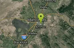
McCowin Park Disc Golf Course
Ammon, Idaho
29.5 miles SShort - longest hole 333'. A few trees and fences for obstacles. Good for a quick game. Public (No Fee)
Disc Golf
Badger Creek
Tetonia, Idaho
29.9 miles EBadger Creek is a stream located just 13.6 miles from Ashton, in Teton County, in the state of Idaho, United States, near France, ID. Whether you’re spinning, baitcasting or fly fishing your...
Camp, Cross-country Ski, Hike, Mountain Bike, Rock Climb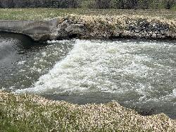
Street kid rapid
Idaho Falls, Idaho
29.9 miles SWA good short rock garden to try out a new whitewater kayak or learn how to whitewater kayak . It's in a canal in the middle of town and in the spring there can be a lot of water running over this...
Canoe, Kayak 1.0-7.5 mi
Idaho Falls Greenbelt
Idaho Falls, Idaho
29.9 miles SWThe Idaho Falls Greenbelt is one of Idaho Falls charms located in the heart of Idaho Falls, next to the historic Idaho Falls downtown. The paved foot-trail is approximately 6 miles around,...
Hike 0.3-0.6 mi
Bear Gulch
Ashton, Idaho
29.9 miles NEBear Gulch is an abandoned ski hill out of operation since 1969. While the vegetation is beginning to take over, there's still some great sledding to be had. It's just far enough into the...
Camp, Cross-country Ski, Hike, Sled
The Pit
Ashton, Idaho
30.1 miles NEThis location is great because there is no one around only locals know of this area and you can shoot anything out there. Watch out for target shooters there! Also stay away from the main road.
Airsoft, Paintball
Porcupine Creek
Ashton, Idaho
30.1 miles NEPorcupine Creek is a hunting, fishing, camping, and swimming spot near Ashton, Idaho in Fremont County within Targhee National Forest. It's surrounded by forests, meadows, and a creek...
Camp, Swim
Mesa Falls
Ashton, Idaho
30.2 miles NEUpper Mesa Falls, aka Big Falls, is an absolutely awesome waterfall on the Henrys Fork of the Snake River. The falls drop 114 ft. and measure 300 ft. across. To get to the falls from the parking lot...
Cross-country Ski, Hike, Kayak
Bitch Creek Trestle
Tetonia, Idaho
30.2 miles EAs part of the Rails to Trails project, this old railroad bridge has been transformed into a very safe little viewing experience for the whole family. You can drive right up to the bridge where...
Hike


