


149 Things to do near Yellowstone National Park
first prev 1 2 3 4 5 6 7 8 next lastShowing results within 50 miles Distance miles of Yellowstone National Park, United States City, Zip, or Address

Box Canyon Trail
Island Park, Idaho
39.7 miles WVarious species of tress and wildflowers can be seen on the trail, as well as songbirds, waterfowl and occasional wildlife. The trail is open for the following uses: Motorcycle Trail Riding, Off...
Hike, Mountain Bike 0.6-1.5 mi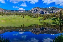
Trout Lake and Buck Lake
Tower Junction, Yellowstone National Park
39.7 miles NEThe Trout Lake trail is a steep 1/2-mile trail through a Douglas fir forest which leads to the lake. Trout Lake is also known to be called Fish Lake and Soda Butte Lake .The most difficult...
Hike
Box Canyon Island Park
Island Park, Idaho
39.8 miles WThe Box Canyon Campground is situated on the canyon rim above the Henry's Fork of the Snake River. There are 16 single and 2 double units, each having tent and camper pads, fire rings, grills...
Canoe
Mesa Falls
Ashton, Idaho
40.2 miles SWUpper Mesa Falls, aka Big Falls, is an absolutely awesome waterfall on the Henrys Fork of the Snake River. The falls drop 114 ft. and measure 300 ft. across. To get to the falls from the parking lot...
Cross-country Ski, Hike, Kayak
Pebble Creek Campground
Northeast Entrance, Yellowstone National Park
41.0 miles NEPebble Creek is a popular campground for fishermen and those seeking a more quiet and smaller campground in Yellowstone National Park. The campsites can fill very early, so get there before 11 AM...
Camp
Falls River, Lower Run
Ashton, Idaho
41.1 miles SWFall River rises on the Madison and Pitchstone plateaus in the southwest corner of Yellowstone National Park, Wyoming and flows approximately 64 miles (103 km) to its confluence with the Henrys Fork...
Whitewater 7.9 mi
Rescue Creek Trail
Mammoth Hot Springs, Yellowstone National Park
41.1 miles NRescue Creek Trail is an 8 mile hike that crosses the Montana/Wyoming boarder. This double trail makes for a leisurely hike through beautiful hills and colorful yellow green grasslands. This trail,...
Hike
Warm River Campground
Ashton, Idaho
41.6 miles SWWarm River Campground is located nine miles northeast of Ashton, Idaho, along the slow-moving Warm River at an elevation of 5,200 feet. Willows line the riverbanks and pine trees offer partial...
Camp 3.2-47.0 mi
Yellowstone Branch Line Trail
Ashton, Idaho
41.7 miles SWYellowstone branch line trail runs from Warm River to the Montana border totaling 39 miles. There are a few places to jump on and off the trail as well as a few smaller trails that branch off of this...
Backpack, Cross-country Ski, Hike, Horseback, Mountain Bike
Mt. Moran
Alta, Wyoming
42.0 miles SMount Moran (12,610 feet (3,840 m)) is a mountain in Grand Teton National Park of western Wyoming, USA. The mountain is named for Thomas Moran, an American western frontier landscape artist....
Hike 3.8 mi
Abandoned Railroad Bed Bike Trail
Gardiner, Montana
42.2 miles NThe Abandoned Railroad Bed Bike Trail, otherwise known as Shortline Trail, is a easily accessible bike trail found just inside the North Entrance of Yellowstone National Park. This bike trail follows...
Mountain Bike 7.6 mi
Mount Jefferson
Island Park, Idaho
43.1 miles WMount Jefferson, at 10, 203 feet is the highest point in the Centennial Mountains, a small, local range on the border of Idaho and Montana a little west of Yellowstone. These mountains consist of a...
Hike 4.2 mi
Lake Marie
Island Park, Idaho
43.1 miles WLake Marie sits on the North slope of Mount Jefferson in Fremont County, Idaho. The trail to get there cuts back and forth across the Idaho Montana border 4 times. Much of the trail is fairly flat...
Backpack, Hike
Sawtell Peak Trail
Island Park, Idaho
43.1 miles WThis trail offers great views of the valley floor, mountain peaks and wildlife. source: fs.usda.gov
Mountain Bike
Bitch Creek Trestle
Tetonia, Idaho
43.2 miles SWAs part of the Rails to Trails project, this old railroad bridge has been transformed into a very safe little viewing experience for the whole family. You can drive right up to the bridge where...
Hike
Sheep Falls on Henry's Fork
Island Park, Idaho
43.2 miles WSheep Falls cascades approximately 25' through a narrow basalt chute on the North Fork of the Snake River near Island Park, Idaho. Compared to nearby Lower and Upper Mesa Falls, that height may...
Hike 0.6-4.7 mi

Harriman State Park
Island Park, Idaho
43.7 miles WHarriman State Park is found 38 miles from Yellowstone along Henry's Fork. This 11,000-acre wildlife refuge is open year round for most activities. In addition to having beautiful scenery and...
Cross-country Ski, Hike, Horseback, Mountain Bike, Snowshoe 0.1-7.3 mi
Leigh Lake
Alta, Wyoming
44.7 miles SEnjoy the grandeur of Grand Teton National Park just a little ways off the beaten path. Leigh Lake rests underneath the majestic Mount Moran. The waters of Leigh Lake flow almost directly into String...
Backpack, Canoe, Hike, Kayak 3.6 mi
String Lake
Alta, Wyoming
45.0 miles SString Lake is a shallow lake that connects Leigh Lake and Jenny Lake at the base of Mount St. John and Rockchuck Peak. From the lakeshore, you can also take in beautiful views of Teewinot and Mt....
Canoe, Hike, Kayak, Swim 10.5-16.2 mi
Paintbrush Canyon
Alta, Wyoming
45.0 miles SBeautiful trail along String Lake, Leigh Lake, and Lake Solitude. For even more solitude, scramble up the rocks to Micah Lake for a beautiful view and even fewer people. You won't find...
Backpack, Hike


