


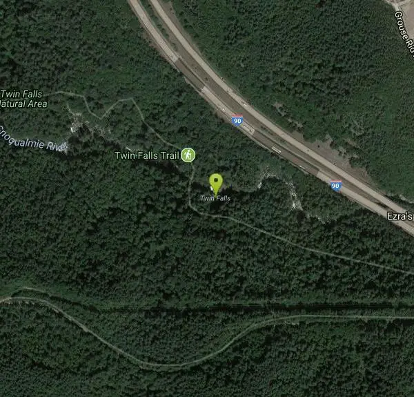
Twin Falls Trail
North Bend, Washington

| Address: | Twin Falls Trail, North Bend, WA 98045, USA |
| GPS: |
47°26'41.4"N 121°41'48.4"W Maps | Directions |
| State: | Washington |
| Trails/Routes: | 1.5 mi |
Waterfalls Trails
Hike
During this three mile hike, you'll be trekking near the river. You will be surrounded by the peaceful sound of rushing water. About a mile and a half into the hike, you will arrive at the viewpoint bridge, which allows people the opportunity to view the beautiful waterfall. Rain or shine, this is a beautiful hike to embark on.
This amazing route has easy access to the river. It also provides plenty open places and overlooks which allow hikers of all ages and skills to go at their own comfortable pace. Due to the closeness to the many larger metropolitan areas near the trail, makes this a heavily used trail during the weekends. Using this trail on weekdays is highly recommended.
History of the location: This trail was forced to be closed at the beginning of 2014 dues to heavy rainfall and erosion that wiped out a key section of the trail. But, fortunately, through the work of EarthCorps, a local nonprofit, the trail was rerouted and rebuilt so the community could once enjoy the iconic Twin Falls and then reopened in May of 2016.
To many people, this is a must-see and must-do hike because it is peaceful, beautiful and enlightening.
More Information
Twin Falls
Visit a trio (yes, trio) of waterfalls just off I-90 on this sure-to-please short trail, perfect for families.
https://www.wta.org/go-hiking/hikes/twin-falls-state-parkTwin Falls Hiking Trail, Riverbend, Washington
A classic family-friendly route through old growth trees with a spectacular waterfall in the mix. Near Riverbend, Washington.
https://www.hikingproject.com/trail/7019080/twin-fallsTwin Falls Trail | A Family-Friendly Hike For All Ages
The Twin Falls Trail is a great hike for all ages in North Bend. The waterfalls highlight the three-mile trek through a moss-covered forest.
https://seattlebloggers.com/twin-falls-trail-fun-hike-for-all-ages/Be courteous, informed, and prepared. Read trailhead guidelines, stay on the trail, and don't feed the wildlife.
Read More- Plan Ahead and Prepare
- Travel & camp on durable surfaces
- Dispose of waste properly
- Leave what you find
- Minimize campfire impacts
- Respect wildlife
- Be considerate of other visitors
Directions
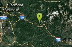
From North Bend, Washington
- Head southwest on N Bend Blvd N/Bendigo Blvd N toward W North Bend Way (0.7 mi)
- At the traffic circle, take the 2nd exit onto the I-90 E ramp to Spokane (0.3 mi)
- Merge onto I-90 E (5.9 mi)
To reach the main trailhead, drive east on I-90 to exit 34 (about 31 miles from Seattle). Turn right at the end of the exit ramp onto 468th Avenue SE, and proceed a little more than half a mile to SE 159th Street. Turn left and continue another half mile where the road dead ends in the Twin Falls parking lot. To reach the Homestead Valley Trailhead, head exit 38 on I-90. From the exit ramp, turn right onto SE Homestead Valley Road. Cross over the South Fork of the Snoqualmie River and take the first right. At the first and second forks, bear left. The road runs out at a junction with the Iron Horse Trail, which you will hike along for about a third of a mile before it connects to the Upper Twin Falls trail. Courtesy of wta.org


Other Hiking Trails Nearby
island lake
North Bend, Washington
8.7 miles EA quieter alternative to the crowded Snoqualmie Pass hikes — shed the weekend throngs who turn back at Talapus or Olallie Lake and discover Island Lake in western Washington.
Camp, Hike, Swim
Granite Mountain
North Bend, Washington
10.2 miles EA steep, rewarding hike up Granite Mountain gaining about 1,000 feet per mile, with panoramic summit views of Mount Rainier, Mount Stewart, and the Teanaway — best tackled after the snow melts.
Backpack, Hike 5.4 mi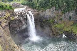
Middle Fork Snoqualmie Trail
North Bend, Washington
10.3 miles NECLOSED. Closed due to landslide activity.
Hike, Mountain Bike 7.0 mi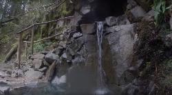
Goldmyer Hot Springs Trail
North Bend, Washington
14.6 miles EA strenuous 4.5-mile-each-way hike through lush forest to the remote Goldmyer Hot Springs — camping and soaking available by reservation and fee at the springs.
Hike, Hot Springs
Skyscraper Mountain Trail
Ashford, Washington
35.8 miles SA gorgeous day hike to 7,078-foot Skyscraper Mountain in Mount Rainier NP, with unobstructed Cascade Range views, Moraine Peak vistas, and Mystic Lake sightings from the summit.
Hike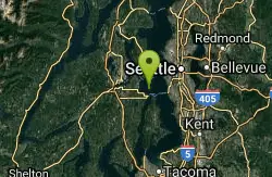
Blake Island
Port Orchard, Washington
37.7 miles WBlake Island State Park near Port Orchard is a 476-acre island paradise for kayaking, bird watching, year-round camping, and Tillicum Village cultural tours.
Camp, Hike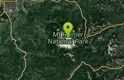
Mount Rainer
Ashford, Washington
40.2 miles SThe most glaciated peak in the contiguous U.S. at 14,410 feet — an active volcano with six major rivers, subalpine wildflower meadows, ancient forest, and abundant wildlife.
Camp, Hike, Mountain BikeNearby Campsites
island lake
North Bend, Washington
8.7 miles EA quieter alternative to the crowded Snoqualmie Pass hikes — shed the weekend throngs who turn back at Talapus or Olallie Lake and discover Island Lake in western Washington.
Camp, Hike, Swim
Jade Lake
Skykomish, Washington
29.9 miles NEA 26-mile overnight backpacking route through the Snoqualmie region past wildflower meadows, Marmot Lake, and a steep talus scramble to a remote alpine lake for swimming.
Backpack, Camp, Swim
Blake Island
Port Orchard, Washington
37.7 miles WBlake Island State Park near Port Orchard is a 476-acre island paradise for kayaking, bird watching, year-round camping, and Tillicum Village cultural tours.
Camp, Hike
Mount Rainer
Ashford, Washington
40.2 miles SThe most glaciated peak in the contiguous U.S. at 14,410 feet — an active volcano with six major rivers, subalpine wildflower meadows, ancient forest, and abundant wildlife.
Camp, Hike, Mountain Bike


