


2.7K Portfolio Locations by cteicheira
first prev 1 next last
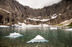
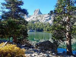
Mirror Lake
Yosemite Valley, Yosemite National Park
2.4 miles E of Yosemite Valley, Yosemite National ParkMirror Lake is a seasonal lake situated in a secluded corner of the beautiful Yosemite Valley. The lake sits at the base of Half Dome and allows a different perspective of the famous monolith. Hikers will also have the chance to see the Tenaya Canyon, Mount Watkins, and Washington Column. Because the lake is seasonal, the best time to visit is in the spring or early summer, when all the snowmelt is running through the area. When the water is calm, hikers will be able to understand why the lake is called Mirror Lake: the still reflection shows the surrounding cliff faces and the crown of Half Dome. If visiting in the late summer, fall, or winter, Mirror Lake becomes Mirror Meadow, filled with grasses and other plant life as well as snow.
The trail is a very easy trail and can be done with the whole family. It is 2 miles round trip to the lake and back, but can be up to 5 miles round trip if taking the loop around the lake. The shorter trail to the lake can be completed in about an hour, and 2-3 hours if doing the full loop. The trail is paved and open only to hikers or biking. Cars are not allowed on the trail, however there are numerous shuttles in the Yosemite Valley that can take hikers to the trailhead.
In the summer the lake becomes a very popular swimming hole, and attracts a lot of visitors. Another attraction to the lake is a small area where previous visitors have left cairns (stacks of rocks usually designating a trail). This "cairn garden" seems to grow with more and more cairns added each year. There is a wide variety from tall cairns to small (smaller than a baby) cairns. It is always fun to walk through the area and see what random places a cairn has been placed, as well as collect some rocks to make your own.

Big Elk Creek
Irwin, Idaho
11.0 miles SE of Irwin, IdahoBig Elk Creak Campground is a very versitile campground with plenty of activities to keep busy. Campgrounds are available, with three group sites that include picnic tables and campfire rings. There is also a site with a covered picnic area available to reserve. Sites are reserved on a first come first serve basis.
Activities include fishing, hiking, horseback riding, kayaking, and more. On the drive into the camp you pass a small lake that is perfect for a more secluded lake experience if you don't want to go out onto Lake Palisade. About five minutes before reaching the campgrounds you will see the boat launch for the small dammed lake outside of the main Palisade Resevoir. From the campgrounds, you can float or kayak down the river to reach the lake. There is plenty of fishing in this small lake, however this lake DOES NOT provide access to the main Palisade Reservoir.
Towards the back end of the campground is the trailhead for the Big Elk Creek Trail. Following this trail will take you up into the mountains of the Caribou-Targhee National Forest, and over into Wyoming. It is perfect for backpacking as well as horseback riding along the trail. In the fall the Aspen trees are changing colors and the Douglas-Fir add some nice contrast in the mountains. The trail is a designated Leave No Trace zone, so please pack out all garabage and anything else you brought with you. The fall is a beautiful time to go, just remember to bring layers because the nights and early mornings get chilly.
Plenty of wildlife to see from mountain goats to squirrels, so just exercise caution while out there. There are bears in the area, so be sure to grab some bear spray and remember to lock up food in bear safes or practice different hanging methods so your food doesn't go missing.
Fees for use (as of 4/28/17)
$12/Night single sites
$24/Night double sites
Group sites are $50/night up to 35 people, $1/person thereafter
$6/night extra vehicle, $6/Day for Day Use Fee
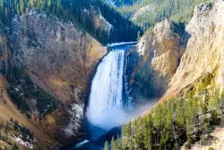
Lower Falls of the Yellowstone
Canyon Village, Yellowstone National Park
1.1 miles S of Canyon Village, Yellowstone National ParkLower Yellowstone Falls is one of the most popular places to visit in Yellowstone, coming in just behind the geyser, Old Faithful. The tallest waterfall in the park, Lower Yellowstone Falls is about 308 ft. Upper Yellowstone Falls feeds this waterfall and can be accessed through a trail before reaching Lower Yellowstone Falls. Because of a turn in the river, both waterfalls are not visible at one time, instead visitors can see just one waterfall at a time.
Both falls are located in a 20 mile long canyon nicknamed the Yellowstone Grand Canyon. The Yellowstone River feeds the falls and it is the longest undamed river in the continental United States. The canyon was created through water eroding the volcanic rock. Lower Yellowstone Falls is particulary beautiful because the large waterfall contrasts with the yellow "rusting" rocks that make up the canyon walls. The iconic "yellow" color in Yellowstone is from the many rocks that oxidize because of the rust and iron found in the rock.
The 308 foot waterfall is taller than Niagra Falls and has many lookout points, offering a variety of views from up close to miles away. There are several trails that can be taken to experience all the views, each with a parking lot before the trailhead. The trails are still open in the winter, however please be aware that they may be icy, as well there are steep drops and switchbacks. In the winter, the trails can only be accessed by snowmobile or snow coaches.
Following the Grand Loop Road, visitors will be able to see the waterfall and access the various trailheads. The summer time will be the busiest time as toursits from all over are enjoying the park. Spring and Fall are especially beautiful, however the road to access the falls opens in mid-April and closes in late October. Turning onto North Rim Drive, visitors will have access to all the view points on that side of the waterfall. The first viewpoint is the Brink of the Lower Falls. Visitors are able to get quite close to the falls, putting them right next to the mouth of the falls as the water goes cascading down below them. The trail is a steep hike down, but a must see. While right at the mouth of the waterfall, visitors can turn and look out at the canyon and see it continue on its 20 mile journey.
Next is the Lookout Point. This offers a panoramic view of the surrounding canyons and waterfall. Though it is several miles away from the actual waterfall, visitors can still hear the booming of water flowing over the falls. The Lookout Point is also the trailhead for Red Rock Point, which gives the closest full view of the waterfall for visitors. It is a steep trail as well, with a sign warning "A steep descent to Red Rock will take you to the North Rim’s closest full view of Lower Falls. Please be prepared for steep grades, steps, and a rough surface. The trail descends rapidly—about 500 feet (150 m) in 3/8 mile (0.6 km). Wear sturdy walking shoes with good tread, and be prepared for a steep uphill return".
Grandview is another lookout point along the North Rim Drive. It provides another panoramic view of Lower Falls, though not as close as the one found at lookout point.
Inspiration Point is the last viewpoint along North Rim Drive. Not much of the Lower Falls are visible from here, but a panoramic view of the canyon reminds visitors just how small they really are when compared to the towering canyon walls.
On the opposite side of the Lower Falls are two additional trails, Uncle Tom's Trail and Artist Point. Taking South Rim Road, visitors will first see the trailhead for Uncle Tom's Trail. This trail consists of 328 steel steps that take visitors about 3/4 of the way down the Canyon. Like the view from the Brink of Lower Falls, visitors will be very close to the falls as the water goes tumbling down below them.
Artist Point is one of the most photographed views in Yellowstone. It is a very easy hike with little elevation gain. Visitors will be awed when looking at the canyon from Artist Point, for it shows just how wide and deep the canyon has become from thousands of years of erosion.

Glacier Point
Yosemite National Park
9.6 miles S of Yosemite National ParkLocated in Yosemite National Park, Glacier Point gives a birds-eye-view of the park you can't find anywhere else. It can be accessed by both hiking and driving through the park, though the roads may be closed until early to late May due to snow. Glacier Point towers over Yosemite Valley, sitting at 7,214 ft compared to the 4,000 ft valley floor.
From Glacier Point visitors are able to see the famous Half Dome, Vernal Falls, Nevada Falls, Yosemite Falls, El Capitan, and the Yosemite High Country. Each season offers a different view and feel for visitors. Come in the winter and you will see a snow covered Half Dome and High Country. Spring comes with the promise of new green leaves and roaring, snowmelt fed waterfalls. The summer still offers plenty of views, though a lot of tourists will be visiting. Fall brings a change of leaves throughout the park, and so it provides a beautiful contrast to the granite cliffs all around.
The trails to get to Glacier Point are the Four Mile Trail and the Panoramic Trail. The Four Mile Trail starts at the valley floor and like the name says, it is about 4.7 miles one way. Hiking up to Glacier Point has a significant level of elevation gain (Valley Floor is 4,000 ft and Glacier Point is 7,214 ft). The trail offers views of the Yosemite Valley that belong in a postcard. Those who hike to the top can enjoy an ice cream at the general store, while taking in the views. On the way down, hikers will see Yosemite Falls constantly in front of them, while the other sights of the valley floor come into view as the trail descends.
The Panoramic Trail is an alternative for going down from Glacier Point. Many hikers alternate between taking the Four Mile Trail up and the Panormaic Trail down (or vice versa). While the sights of the Four Mile Trail include many of the valley floor sights, the Panoramic Trail offers views of Illilouette, Nevada, and Vernal Falls. The trail ends at a different point than the Four Mile Trail, but hikers can take one of the free shuttles throughout the park.

Jade Lake
Skykomish, Washington
7.7 miles E of Skykomish, WashingtonJade Lake is a beautiful treasure of a lake located in the Snoqualmie region of Washington. This trail is about 26 miles and is usually done as an over night backpacking trip. This hike will take backpackers past some beautiful lakes as well as provide excellent views of the nearby moutains.
The trail to Jade Lake has several starting points, some will have parking lots available, but they fill up rather quickly on weekends. Following the Deception Creek trail, hikers will go for about 5 miles until they reach Deception Pass. Here the trail becomes a junction for several other trails in the area, but hikers will want to take the trail for Marmot Lake. At first, this part of the trail will be about a 2 mile descent through wildflower meadows (depending on the season) followed by a 2 mile climb back up, eventually reaching Marmot Lake. Some people choose to camp here for the first night and catch their breath at this beautiful lake. This lake is great for swimming and provides a refreshing soak after a long hike.
After resting at Marmot Lake, continue on the east side of the lake where a trail will take hikers up a steep scramble of talus. This eventually opens up into an alpine meadow, and be sure to look for local wildlife while hiking around. The next lake hikers will see is No-Name-Lake, and from here it is only a short distance to Jade Lake. At Jade Lake, there are several other activities to do including swimming or fishing in the lake. In the mountains surrounding Jade Lake is a glacier that can be hiked to. If hiking to the glacier, it might be best to have some crampons and an ice axe. This makes the hike much easier, though isn't required. Views at Jade Lake include Mount Daniel, which is the highest point in Kings Canyon. Most people will take a day pack with them so they don't have to carry around their heavy backpack while exploring the area.
For the return trip, just take the trail back to the parking lot. This can also be split into multiple days if wanting to take it slower, or it can be done in one day.
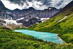
Cracker Lake Trail
Many Glacier, Glacier National Park
0.1 miles SE of Many Glacier, Glacier National ParkWhat impresses people most about this lake is the surreal turquoise color of the lake. Regardless of the beautiful mountain cliffs and forests found along the trail, Cracker lake is definitely a must see. Located in the Many Glacier area of Glacier National Park, the trail is about 12.5 miles one way, though it is a good hike to break up into a two day trip if using the backpacking campgrounds. The beginning of the hike has a lot of horse traffic, which makes the trail either really muddy or very dusty (depending on the time of year). For most of the beginning, the trail meanders through thick forests and along some streams.
The trail starts out at Many Glacier Hotel parking lot. From here the trail follows Allen creek, eventually taking hikers through thick forest. This trail goes through active bear country, so please take precautions. Going through thick forests and around blind turns makes it easier to run into a bear if not careful. Carry bear spray and be alert. While going through the forest, a waterfall will come into view which is falling from one of the surrounding mountains. There is no trail to reach the waterfall, but it is breathtaking to see. The forest will finally break off when hikers reach the basin where Cracker lake is located. The trail continues for another mile and a half to the lake overlook. The mountains that can be seen on the trail and from the lake are Mt Siyeh and Allen Mountain.
There are three campsites available on the edge of Cracker lake. Those who decided to camp here will be able to camp beneath one of the largest rock faces on the continent. One drawback to the campsites is that there is no tree coverage, but everything is out in the open. The weather definitely will play into how comfortable of a night it would be at the campsites. The surrounding mountains have very interesting and beautiful sediment layers and were carved from glaciers thousands of years before. There is also an old copper mine and some old mining equipment near the lake. Hikers are prohibited from entering into the mine.
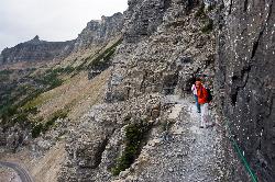
Highline Trail
Logan Pass, Glacier National Park
0.1 miles SE of Logan Pass, Glacier National ParkOne of the most popular hikes in Glacier National Park. The Highline Trail is on many people's hiking lists because it showcases all of the beauty of Glacier National Park in just one hike. This hike takes hikers up through Alpine meadows, the top of the Continental Divide, and past several lakes.
The trail is found at the Logan Pass Visitors Center. From here, hikers will cross the road and begin along the Highline Trail. As hikers make their way along the trail and up to the Continental Divide, they will face some significant elevation gain. The trail is split into two parts, the southern half and the northern half. The southern half is about 7 miles one way and finishes at Granite Park Chalet, with the northern half picking up from Granite Park Chalet and continuing to Waterton Valley/Flattop Mountain Trail Junction.
From the beginning, the trail goes through a meadow and then begins to climb along the Garden Wall Divide. There is some exposure along this part of the trail, though the trail is pretty wide. During the summer a cable is put up along the Garden Wall for extra support while hiking, however this part of the trail does not last very long. After hiking along the cliff face, the trail goes through several grassy meadows with streams flowing, making a good place to refill on water. The next stop is a rock field which then leads to switchbacks on the east side of Haystack Butte. When hiking over Haystack Butte, there will be a trail for Grinnell Glacier Overlook. This is a good detour hike for those who are fit enough for some extra miles, and offers excellent views of Many Glacier and Upper Grinnell Lake.
After the butte, the trail makes a slight decline to Granite Park Chalet. This chalet sells water and food for hikers, includes bathrooms and rooms to sleep in. If hikers wish to continue from Granite Park Chalet on the northern half of the trail, they will continue from here for about 11 miles. Depending on how late in the season hikers go, the northern half of the trail may still have significant snow in places. However, the trail is still beautiful and often less crowded than the southern half. The northern half takes hikers toward Ahern Pass and Sue Lake. Towards the end of the trail there is a campground where people can choose to spend the night and then return back to Logan Pass the next day.
This hike has plenty of wildlife and nature to see. It isn't uncommon to see Mountain Goats as well as deer and bighorn sheep. Be aware, this is bear country and it is advised to carry bear spray when hiking.
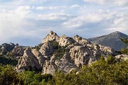
City of Rocks National Reserve
Malta, Idaho
23.3 miles SW of Malta, IdahoThe City of Rocks, or "The City" as locals call it, is one of the best places in the country to go rock climbing. Throughout the valley granite spires dominate the skyline, reaching anywhere from 30-600 ft. Because there are so many rocks that can be climbed, the level of difficulty ranges from 5.6 all the way to 5.13. There are over 700 devloped routes throughout the reserve, with different options for climbing like trad or sport climbing. Unlike most climbing spots, City of Rocks allows a full range of technique in one location, making it the perfect place for both the new climber and the seasoned, technical climber. Permits are not required to climb, though climbing is not allowed on any rocks within the California Trail Corridor.
Some of the more popular areas to climb are the Bread Loaves, Bath Rock, Parking Lot Rock, Elephant Rock, and Treasure Rock. Each of these rocks may have routes as easy as a 5.6 right next to something as difficult as a 5.11. Most of these rocks have parking lots in close proximity to the rocks. The parking lot for Bath Rock includes a water spout and bathrooms. Campgrounds can be found throughout the reserve, though they do require a fee. Many routes will only have two or three permanent bolts on the rock, requiring additional equipment for setting up routes. In order to preserve the natural beauty of the city regulations were put in place for rock climbers. Be aware of different regulations before going to the city.
Bread Loaves offers some of teh most well known and climbed routes in the reserve. Walls such as Decadent Wall include routes that go from a 5.7 to a 5.11a. One of the most popular climbs is known as Carole's Crack, a 5.8 featuring a double crack at the top. Many people will rappel down from the top or practice lead climbing on these routes. The best time to climbthese routes is during the morning because they aren't being hit by the sun. As the day goes on, shade will become scarce around the walls.
Bath Rock has a large parking lot with views of the valley as well as some nice campgrounds. On top of Bath Rock has a wide variety of routes as well, with routes ranging from 5.4 to 5.12c. There are some good climbs to introduce new climbers to crack climbing. At the top, climbers will be greated by a nice view of all the other peaks in the area they can climb. On the west side, there is a clear trail with steps leading to the routes, as well as fences built near the wall to keep people from harming the nature.
There is plenty of history in City of Rocks, both climbing history as well as pioneer history. Many pioneers used to come through this area on the California Trail and signed their names on some of the surrounding rocks with axle grease. The climbing history does not date back as far as the pioneers, but began in the 1960's. Today there is a rock climbing festival held in the park every September. This festival offers introduction to climbing courses, as well as demo's of different climbing projects and a lot of climbing. During the summer the park services offer climbing classes for any interested.
Iceberg Lake
Many Glacier, Glacier National Park
0.9 miles W of Many Glacier, Glacier National ParkA pleasant trip into Glacier National Park, coming out to be about 9 miles round trip. The lake sits at the basin of mountains carved by glaciers thousands of years ago. Along the way, hikers will have incredible views of several of the peaks in the area: Mount Grinnell, Swiftcurrent Mountain, Mount Wilbur, and Ptarmigan Wall.
Starting at the Swiftcurrent Inn, the trail steadily climbs in elevation, though once hikers reach the fork in the trail and continue to the left, the elevation levels out for a bit. From the trailhead, the trail will go through a very open area, which is where the views will be stunning. However, about 1.5 miles into the trial, hikers will go through a thick forest as they progress towards Iceberg Lake. Along the way is the Ptarmigan waterfall, though it is hard to get a full view of it from the trail, and the area around the waterfall is very steep and unsafe for hiking. Continuing past the waterfall and keeping left at the trail junction, hikers will eventually exit the forest and be greeted by the steep walls of a cirque, whose basin holds Iceberg Lake. The walls of the cirque are actually an arete, also known as the Ptarmigan Wall, and towers 1500 ft above the trail. As the trail comes to the lake, visitors will get to walk through an Alpine meadow, and depending on the time of year, see many wildflowers in bloom.
This area is known to have bears and so hikers are advised to carry bear spray, stay in larger groups, and make noise when going through areas with particularly high bear activity. Ask the park rangers if any of the trails or areas are closed at the time before beginning on a hike.
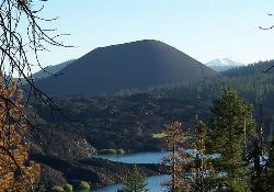
Cinder Cone and the Fantastic Lava Beds
Lassen County, California
31.0 miles W of Lassen County, CaliforniaOne of the four types of volcanos found in Lassen Volcanic National Park, Cinder Cone stands at 6,907 ft elevation and 750 ft above the surrounding landscape. Cinder Cone was formed in the 1600's, though lava flows at its base caused the then active volcano to die down. Today, Cinder Cone is not active, and is a hike that allows visitors to experience a cinder cone first hand. Along the way, hikers will see the Painted Dunes and the Fantastic Lava Beds.
The trail begins from the Butte Lake parking lot and is about four miles round trip, taking approximately 3 hours to hike it all. Similar to hiking in sand, the trail is very loose terrain and can be very taxing regardless of how short of a hike it seems. When hikers reach the top they will have the option to take in the view from the summit or continue down into the crater of the cinder cone.
From the top hikers will see the Painted Dunes, which were formed after the erruption of the cinder cone, and as the lava cooled off, left behind orange hills at the base of the cinder cone. The Fantastic Lava Beds are also visibile and create stark contrast from the forested landscape. The lava beds actually helped to form the two lakes in the area, damming the lakes when the lava beds were first created.
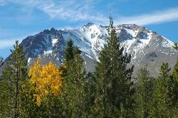
Lassen Peak
Mineral, California
9.9 miles NE of Mineral, CaliforniaLassen Peak is the largest plug dome volcano in the world and the second tallest volcano in Northern California. It is situated in Lassen Volcanic National Park, one of the few places in the world where all four types of volcanos can be found in one place. Part of the Cascade Range, Lassen Peak is the southernmost volcano in the range. It has not errupted since the early 1900's, though the devastated land from the erruptions helped to create Lassen Volcanic National Park.
The peak can be climbed year-round, though wintertime sees a significant amount of snow on the trail. Sitting at 10,457 ft, Lassen Peak has a 5 mile round trip hike. This can take about 3-5 hours to hike and includes a steep 2,000 ft elevation gain. Hikers will begin the trek from the peak parking lot. Along the way, hikers will see fantastic views of some of the different areas of the park as well as one of the best views of the Devastated Area (the remaining aftermath of the early erruptions). Lassen Peak is an active volcano, however it is currently considered a dormant, active volcano.
This trail is just one of the 150 miles of trails available throughout the Lassen Volcanic National Park.
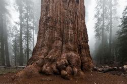
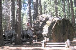
General Sherman Tree in Sequoia National Park
Three Rivers, California
13.0 miles NE of Three Rivers, CaliforniaWithin Sequoia National Park, the biggest attraction is General Sherman, the world's largest tree. It is believed that the tree is about 2,000 years old, and was named after the Civil War general, General William Tecumseh Sherman in 1879. Nestled in the section of the park, can drive or hike to the tree. There are walking trails that take visitors right up to the tree and allow them to marvel at the vast size of the tree. Two trails can take visitors to the tree, the General Sherman's trail and Big Tree's trail. A free shuttle is also available for visitors to take and runs from May through September each year.
The General Sherman Tree is the world's largest tree, measured by volume. It stands 275 feet (83 m) tall, and is over 36 feet (11 m) in diameter at the base. Sequoia trunks remain wide high up. Sixty feet above the base, the Sherman Tree is 17.5 feet (5.3 m) in diameter.Courtesy of nps.gov
Crystal Crag
Mammoth Lakes, California
3.8 miles SW of Mammoth Lakes, CaliforniaVisible from all the lakes around, Crystal Crag stands tall and is a popular place to rock climb and go mountaineering. It stands at 10,100 ft in elevation, and includes a North Ridge and a South Ridge. With many other well known climbing spots nearby (i.e. Yosemite, Kings Canyon, etc) this spot isn't too crowded with climbers.
The crag is accessed by taking the Crystal Lakes trail and then continuing around the lake. Climbers can find a climbers trail near the lake which will then take them to the base of the crag, about a 45 minute hike. There is a variety of ascents with a variety of difficulty throughout. Most of the routes are multi-pitch if climbers want to go all the way to the summit. Routes range from 5.5-5.11a. The rock on the crag is mostly granite, though one spot has an area of white quartz, where the name Crystal Crag most likely comes from. There can be a lot of loose rock when people are climbing on the North Face Route, so please use caution. The East Face has some sport routes set up, but loose rock from the North Face route sometimes falls into the East Face route.
Calaveras Big Trees State Park
Arnold, California
2.7 miles NE of Arnold, CaliforniaCalaveras Big Trees State Park is a little known grove of Sequoias located in the beautiful Northern California gold country. The area became a State Park in 1931 in order to preserve the trees found in the North Grove, including the "Discovery Tree". There are two groves of Sequoias, the North and South Grove, which are connected through boardwalk style trails. The North Grove has about 100 mature Giant Sequia trees and the South Grove has about 1,000 mature Giant Sequoias. Weaving through the different trees, visitors will be able to stand up close and even crawl their way through a few of them. During the spring and summer the temperature is perfect for hiking and camping, and the area provides a great escape from the heat of the Central Valley.
Some of the more famous attractions are "Discovery Tree", which was actually cut down in 1853 and is now referred to as "The Stump". The stump is about 24 ft in diameter and visitors can walk up on top, which has been smoothed over time from the many visitors and dances that used to be held there.
Pioneer Tree is a famous drive through tree, though due to a winter storm has since fallen. Many of the large trees throughout the park will show scars from attempts to cut them down or to remove their bark. Each tree in the park has its own story and history. The largest tree in the park is the Louis Aggasiz tree. This tree was named after an early naturalist and stands over 250 ft tall.
There is plenty to do in the park from ranger guided tours and activities for children, to hiking and camping. There are seven different trails that visitors can follow and the day can quickly be spent meandering through the forest and staring up at the trees. Spring time brings with it a blooming of mountain dogwood flowers, and the fall offers a changing of tree leaves throughout the park. The park is open in the winter, though some roads are closed, and the trails are not groomed.
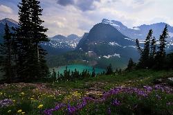
Grinnell Lake
Many Glacier, Glacier National Park
2.9 miles SW of Many Glacier, Glacier National ParkGrinnelll Lake was named after George Bird Grinnell who helped make Glacier into a national park. This lake allows visitors to see one of the remaining glaciers in the park and take in the immense beauty of the mountains surrounding the lakes.
There are two options for hiking to this lake, one is by boat ferry and the other is by hiking the long way. The trail itself is about 7.5 miles round trip, but takes hikers along the banks of two glacier fed, subapline lakes, Lake Josephine and Swiftcurrent Lake, before reaching Grinnell Lake. There is also a waterfall that hikers will pass through which allows some additional scenery. The trail is pretty flat, with not much elevation gain as hikers meander through forests and along the lakes. When hikers reach Lake Josephine, there is the option to take a ferry across the lake, continue on a trail around the lake, or a trail up to Grinnell Glacier. Reserving tickets for the ferry ahead of time ensures that hikers will have a place on the boat. Taking the ferry cuts off a significant amount of time and miles from the overall hike.
Grinnell Glacier is the glacier that feeds Grinnell Lake, Lake Josephine, and Swiftcurrent Lake. The Grinnell Glacier trail climbs 1,500 ft in elevation to the top of the glacier above Grinnell Lake. It provides beautiful views of the mountain area.
After crossing Lake Josephine, there is only one trail that hikers can take to Grinnell Lake. While following this trail, about .85 miles from the junction is a side trail that goes to Hidden Falls Overlook. This provides a brief look at a 40 ft waterfall as a detour from the main trail.
For the last 1/3 of the trail, hikers will cross on a boardwalk trail system as they trek over streams fed from Grinnell Lake. The trail ends on a sandy bank of the lake. This view showcases the clear, turquoise water of the subalpine lake, as well as the small streams cascading over the mountains from the glacier. If binoculars are available, hikers can look up above the lake and see other hikers who took the trek up to the glacier.
Along the way, visitors will see Mt Grinnell, Angel Wing, Allen Mountain, and the Garden Wall.
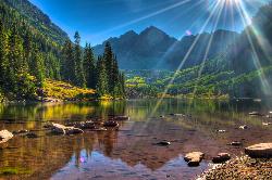
Maroon Bells
Aspen, Colorado
9.2 miles SW of Aspen, ColoradoOne of the most photographed peaks in Colorado and possibly North America, the Maroon Bells are two fourteeners framing the beautiful Maroon Lake. Very popular to visit in every season, the Maroon Bells area is home to amazing wildlife, beautiful nature, and impressive peaks. There are multiple trails that leave from the Maroon Lake parking lot. Maroon Bells is famous for the maroon color of the mountains. The distinct red color is from iron in the rock oxidizing. The mountains were formed through glaciers, which then formed the lakes found in the area.
Getting to the lake is pretty easy. There is a parking lot, and then a two minute walk from the parking lot will take visitors to the banks of the lake. During the summer and early fall the parking lot is closed from 8am-5pm and the only way to get to the lake is by a shuttle. If going to the lake before 8am or after 5pm, the parking lot will be open. Around the lake, visitors can hike around the lake, go fishing, or take pictures of the beautiful scenery.
The trails range from easy to difficult as well as how much time they take to hike. The Scenic Loop trail takes visitors around the lake towards the mountains. It is about 3 miles and elevation gain is not too significant.
Maroon Creek Trail is about 2.5-3.5 miles one way, depending on which trail visitors take. This trail goes down from the lake and follows a creek which will offer a good chance at seeing some wildlife. The mountains will be behind visitors, so be sure to turn around and look at the breathtaking views.
Crater Lake Trail begins at the opposite end of the lake from the parking lot. Visitors will see a forest service bulletin board and should take the trail for Crater Lake/West Maroon. This trail is about 3.6 miles roundtrip and will take visitors to Alpine Meadows and a lake higher up in the country. Camping and fishing are not allowed at Crater Lake, so please be careful and be sure to pack out whatever was packed in.
Willow Lake Trail is a difficult hike that goes further into the backcountry, past Crater Lake. Depending on weather and hiker ability, some might prefer to make this hike an overnight trip. Hikers will pass through steep switchbacks that will lead up to Willow pass and then further on to Willow Lake.
A Colorado Fishing Permit is required for fishing at Maroon Lake.

Crystal Lake
Mammoth Lakes, California
3.8 miles SW of Mammoth Lakes, CaliforniaUnlike many hikes in the Sierra's, Crystal lake can be done as a day hike and as the perfect way to get away for a bit. As hikers make their way to the lake, they will see the monolith Crystal Crag, lakes such as Lake George, Lake Marie, and Lake Mamie. The trail is about 3.2 miles round trip with some elevation gain and switchbacks. While it may be appealing to just go straight up and avoid the many switchbacks, the trail can get pretty steep and so this is not the safest option. Overall the trail is very well kept, with a lot of shade along the way to help keep the summer sun off hikers backs. Dogs are allowed on the trail, but observe any additional rules that the area might have concerning pets. Along the way, be sure to stop and lookout and see the many beautiful lakes and forests. Hikers will go until they reach the crest of the trail and will then descend down to the lake. Once at the lake hikers can go either to the west end or the east end. The west end tends to have more of a rocky shoreline, though still pleasant. On the east side, the shoreline is a bit more flat and give more of an area to enjoy a picnic or soak in the sun.
There is a parking lot at the trailhead for Lake George, and if that fills up, visitors can park on the side of the road without paying a fee, however they need to be completely off the road or will be fined. In addition to hiking at Crystal Lake, visitors can take a quick dip in the lake, go fishing, or enjoy a nice picnic on the shore of the lake.
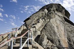
Moro Rock
Tulare, California
40.0 miles NE of Tulare, CaliforniaHike through the mountains of Sequoia National Park and you will come to Moro Rock, which offers views of the Great Western Divide. With 400 laddered stpes, you will feel like you are standing on top of the world.
The trail is about a quarter of a mile long, and the rock itself rises about 6,725 ft in elevation. There is a way for visitors to drive up to a parking lot where visitors will only have to hike about 300 ft to the top. The trail is not very wide, but should be hiked single-file. Along the trail there are a few ledges that might make the faint of heart a little worried, but they pass quickly! Stopping along the trail to catch a breath will reward visitors with amazing views. Along the trail there are information panels providing some history about the rock and surrounding areas, a little science about how the rock was formed, and a list of visible summits from Moro Rock.
The rock is also open to rock climbers, however during the summer the area is closed off for falcon nesting. There are many routes to climb, anywhere from 5.7 to 5.12. The rock is made from the same granite as Yosemite's Half Dome, and is mainly free climbing with some aid routes as well.


