


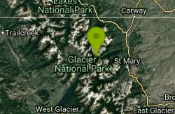
Cracker Lake Trail
Many Glacier, Glacier National Park
| Address: | Cracker Lake Trail, Browning, MT 59417, USA |
| GPS: |
48°47'43.1"N 113°39'22.1"W Maps | Directions |
| State: | Montana |
| Trail Length: | 12.50 miles |
| Trail Type: | Out & Back |
| Hike Difficulty: | Intermediate |
| Elevation Gain: | 1434 feet |
| Trails/Routes: | 11.8 mi |
Lakes Trails Wildflowers National Park
Backpack, Camp, and Hike
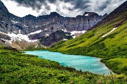
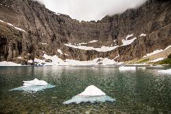
What impresses people most about this lake is the surreal turquoise color of the lake. Regardless of the beautiful mountain cliffs and forests found along the trail, Cracker lake is definitely a must see. Located in the Many Glacier area of Glacier National Park, the trail is about 12.5 miles one way, though it is a good hike to break up into a two day trip if using the backpacking campgrounds. The beginning of the hike has a lot of horse traffic, which makes the trail either really muddy or very dusty (depending on the time of year). For most of the beginning, the trail meanders through thick forests and along some streams.
The trail starts out at Many Glacier Hotel parking lot. From here the trail follows Allen creek, eventually taking hikers through thick forest. This trail goes through active bear country, so please take precautions. Going through thick forests and around blind turns makes it easier to run into a bear if not careful. Carry bear spray and be alert. While going through the forest, a waterfall will come into view which is falling from one of the surrounding mountains. There is no trail to reach the waterfall, but it is breathtaking to see. The forest will finally break off when hikers reach the basin where Cracker lake is located. The trail continues for another mile and a half to the lake overlook. The mountains that can be seen on the trail and from the lake are Mt Siyeh and Allen Mountain.
There are three campsites available on the edge of Cracker lake. Those who decided to camp here will be able to camp beneath one of the largest rock faces on the continent. One drawback to the campsites is that there is no tree coverage, but everything is out in the open. The weather definitely will play into how comfortable of a night it would be at the campsites. The surrounding mountains have very interesting and beautiful sediment layers and were carved from glaciers thousands of years before. There is also an old copper mine and some old mining equipment near the lake. Hikers are prohibited from entering into the mine.
More Information
Be courteous, informed, and prepared. Read trailhead guidelines, stay on the trail, and don't feed the wildlife.
Read More- Plan Ahead and Prepare
- Travel & camp on durable surfaces
- Dispose of waste properly
- Leave what you find
- Minimize campfire impacts
- Respect wildlife
- Be considerate of other visitors
Directions
From Many Glacier, Glacier National Park
- Head south toward Continental Divide TrailDestination will be on the right(0.1 mi)


Trails
Distance ?
11.8 miles Round TripElevation Gain ?
1,060 feetReal Ascent ?
1,860 feetReal Descent ?
800 feetAvg Grade (2°)
3%Grade (-21° to 28°)
-39% to 54%Elevation differences are scaled for emphasis. While the numbers are accurate, the cut-away shown here is not to scale.
Other Hiking Trails and Backpacking Trails Nearby
Iceberg Lake
Many Glacier, Glacier National Park
1.0 miles WNine miles of alpine trail deliver sweeping views of Ptarmigan Wall, Mount Grinnell, and Mount Wilbur before arriving at an iceberg-dotted cirque lake in Glacier NP.
Backpack, Camp, Hike 10.5 mi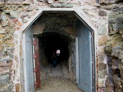
Ptarmigan Tunnel
Many Glacier, Glacier National Park
1.0 miles WA long hike to a hand-carved 240-foot tunnel through the Ptarmigan Wall at Glacier National Park, opening to views of Seaward Mountain and Elizabeth Lake — open mid-July through early October.
Backpack, Hike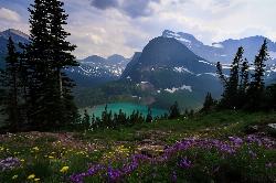
Grinnell Lake
Many Glacier, Glacier National Park
2.9 miles SWA 7.5-mile round-trip hike along glacier-fed subalpine lakes to a turquoise glacial lake in Glacier National Park — with a waterfall along the way and an optional ferry across Lake Josephine.
Hike, Swim
Siyeh Pass Trail
Logan Pass, Glacier National Park
6.5 miles SA top-of-the-world point-to-point hike through Glacier's Preston Park meadows to a high pass with glacier views, mountain goats, and bighorn sheep.
Backpack, Hike
Clements Mountain Trail
Logan Pass, Glacier National Park
7.4 miles SA four-mile round-trip climb of Clements Mountain in Glacier National Park, with several routes of varying difficulty and significant elevation gain — often confused with nearby Reynolds Mountain.
Backpack, Camp, Hike, Rock Climb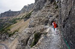
Highline Trail
Logan Pass, Glacier National Park
7.4 miles SOne of Glacier National Park's most celebrated hikes — the Highline Trail spans alpine meadows, the Continental Divide, and the Garden Wall with mountain goats, wildflowers, and views to rival anything in the park.
Backpack, Hike 5.0 mi
Hidden Lake
Glacier National Park
7.5 miles SA 6.6-mile round-trip hike from Logan Pass through alpine meadows, dense forest, and rocky terrain to the crystal-clear waters of Hidden Lake, with bighorn sheep and mountain goats along the way.
Hike 0.6 mi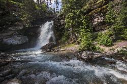
Baring Falls
Glacier National Park
8.5 miles SA moderate trail hike in Glacier National Park to 30-foot Baring Falls dropping into crystal-clear water — with scenic mountain overlooks, wildlife, and an optional gorge viewpoint 1.5 miles beyond.
Hike 1.4-4.6 mi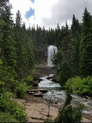
St Mary and Virginia Falls
Rising Sun, Glacier National Park
8.6 miles SA scenic 3.7-mile roundtrip hike past St. Mary Falls' 50-foot two-tiered drop to the upper and lower tiers of Virginia Falls, best in early season when snowmelt is rushing.
Hike 0.9 mi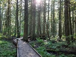
Trail of the Cedars
Apgar Village, Glacier National Park
10.9 miles SWAn easy wheelchair-accessible loop through towering 500-year-old cedars up to 100 feet tall in Glacier National Park, with gorge views of glacial Avalanche Creek and a footbridge over the water.
Hike 4.5 mi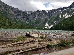
Avalanche Lake
Apgar Village, Glacier National Park
10.9 miles SWHike near Apgar Village, Glacier National Park
Hike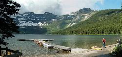
Cameron Lake
Waterton, Glacier National Park
23.4 miles NWA picturesque Canadian glacial lake in Waterton Lakes National Park surrounded by mountain scenery, avalanche-sculpted shores, kayaking, fishing, and Herbst Glacier views.
Backpack, Camp, Hike
Jewel Basin
Kalispell, Montana
44.9 miles SBeautiful hiking area in the Montana wilderness, Jewel Basin is home to lakes with plenty of fish, and many peaks to ascend.
Backpack, Camp, HikeNearby Campsites
Many Glacier Campground
Many Glacier, Glacier National Park
1.0 miles WCamp near Many Glacier, Glacier National Park
Camp 9.7 mi
Iceberg Lake
Many Glacier, Glacier National Park
1.0 miles WNine miles of alpine trail deliver sweeping views of Ptarmigan Wall, Mount Grinnell, and Mount Wilbur before arriving at an iceberg-dotted cirque lake in Glacier NP.
Backpack, Camp, Hike
Clements Mountain Trail
Logan Pass, Glacier National Park
7.4 miles SA four-mile round-trip climb of Clements Mountain in Glacier National Park, with several routes of varying difficulty and significant elevation gain — often confused with nearby Reynolds Mountain.
Backpack, Camp, Hike, Rock Climb
Rising Sun Campground
Glacier National Park
9.2 miles SEMore than 150 sites in eastern Glacier National Park close to Going-to-the-Sun Road, St. Mary's Falls and Red Rock Falls trails, and frequent bear, elk, and bighorn sightings.
Camp
St. Mary Campground
Glacier National Park
10.1 miles EOver 200 campsites on the edge of Glacier National Park with flush toilets, showers, and quick access to Going-to-the-Sun Road, the Highline Trail, and St. Mary Lake.
Camp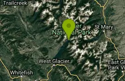
Avalanche Campground
Glacier National Park
11.0 miles SWNestled on Glacier National Park's west side, Avalanche Campground puts 128 sites, flush toilets, and bear-proof storage right next to the Trail of the Cedars and the stunning Avalanche Lake hike.
Camp
Sprague Campground
Glacier National Park
16.7 miles SWAn 85-site campground on the west side of Glacier National Park near Lake McDonald, with swimming, boating, fishing, wildlife viewing, and the Trail of the Cedars nearby.
Camp
Cut Bank Campground
Glacier National Park
18.3 miles SEA peaceful forested campground along Cut Bank Creek in Glacier National Park with 48 first-come sites, nearby hiking trails, and access to fishing at St. Mary Lake.
Camp
Fish Creek Campground
Glacier National Park
22.8 miles SWA 193-site Glacier National Park campground along Fish Creek, surrounded by pine and cedar forest, with mountain views, fire rings, and access to the Trail of the Cedars nearby.
Camp
Cameron Lake
Waterton, Glacier National Park
23.4 miles NWA picturesque Canadian glacial lake in Waterton Lakes National Park surrounded by mountain scenery, avalanche-sculpted shores, kayaking, fishing, and Herbst Glacier views.
Backpack, Camp, Hike
Apgar Campground
Apgar Village, Glacier National Park
23.9 miles SWCampsites on the shores of Lake McDonald within Glacier National Park, with easy access to the Apgar Visitor Center, nature center, nearby hiking, and the western entrance to Going-to-the-Sun Road.
Camp
Two Medicine Campground
Glacier National Park
24.9 miles SECamp near Glacier National Park
Camp
Bowman Lake Campground
Glacier National Park
25.0 miles WA stunning lakeside campground in the heart of Glacier National Park with 50+ campsites, bear-proof lockers, nearby hiking trails, and access to swimming, fishing, and paddling on Bowman Lake.
Camp
Logging Creek Campground
Glacier National Park
25.3 miles WA first-come, first-served campground nestled in the Many Glacier area of Glacier National Park, with 49 sites and close access to the Grinnell Glacier and Swiftcurrent trails.
Camp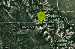
Kintla Campground
Glacier National Park
26.0 miles NWA 26-site campground on the shores of Kintla Lake inside Glacier National Park — fire pits, bear boxes, vault toilets, and the Kintla Lake Trail at your doorstep.
Camp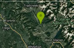
Quartz Creek Campground
Glacier National Park
26.4 miles WA peaceful 22-site campground in the heart of Glacier National Park, close to Going-to-the-Sun Road and a short hike from iconic Grinnell Glacier.
Camp
Jewel Basin
Kalispell, Montana
44.9 miles SBeautiful hiking area in the Montana wilderness, Jewel Basin is home to lakes with plenty of fish, and many peaks to ascend.
Backpack, Camp, Hike


