


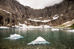
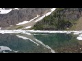
Iceberg Lake
Many Glacier, Glacier National Park
| Address: | Continental Divide Trail, Browning, MT 59417, USA |
| GPS: |
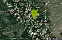
48°47'56.0"N 113°40'39.3"W Maps | Directions |
| State: | Montana |
| Trail Length: | 9.00 miles |
| Trail Type: | Out & Back |
| Trails/Routes: | 9.7 mi |
Lakes Glaciers Trails Rocks Wildflowers National Park
Backpack, Camp, and Hike
A pleasant trip into Glacier National Park, coming out to be about 9 miles round trip. The lake sits at the basin of mountains carved by glaciers thousands of years ago. Along the way, hikers will have incredible views of several of the peaks in the area: Mount Grinnell, Swiftcurrent Mountain, Mount Wilbur, and Ptarmigan Wall.
Starting at the Swiftcurrent Inn, the trail steadily climbs in elevation, though once hikers reach the fork in the trail and continue to the left, the elevation levels out for a bit. From the trailhead, the trail will go through a very open area, which is where the views will be stunning. However, about 1.5 miles into the trial, hikers will go through a thick forest as they progress towards Iceberg Lake. Along the way is the Ptarmigan waterfall, though it is hard to get a full view of it from the trail, and the area around the waterfall is very steep and unsafe for hiking. Continuing past the waterfall and keeping left at the trail junction, hikers will eventually exit the forest and be greeted by the steep walls of a cirque, whose basin holds Iceberg Lake. The walls of the cirque are actually an arete, also known as the Ptarmigan Wall, and towers 1500 ft above the trail. As the trail comes to the lake, visitors will get to walk through an Alpine meadow, and depending on the time of year, see many wildflowers in bloom.
This area is known to have bears and so hikers are advised to carry bear spray, stay in larger groups, and make noise when going through areas with particularly high bear activity. Ask the park rangers if any of the trails or areas are closed at the time before beginning on a hike.
More Information
Glacier National Park Itinerary
This Glacier National Park Itinerary will help you get started as you plan your vacation to Glacier National Park.
https://www.justgotravelstudios.com/collections/national-park-itineraries/products/glacier-national-park-itinerary?ref=9zpxis0diinHiking the Iceberg Lake Trail in Glacier National Park
The Many Glacier area of Glacier National Park is full of great hikes, and the Iceberg Lake Trail is definitely one of the best. The reward doesn’t come easy, though. At just under 10 miles (round trip), you’ll have to work to get there. However, for those that are willing to take on the trip, they’ll enjoy breathta
https://www.justgotravelstudios.com/blogs/just-go-travel-blog/just-go-to-glacier-national-park-hiking-the-iceberg-lake-trailHiking the Iceberg Lake Trail in Glacier National Park
The Iceberg Lake Trail in Glacier National Park is one of the “crown jewel” hiking trails in the park. To put it quite simply, the Iceberg Lake Trail offers one of the most scenic hikes you can find. And to top if off, the trail has to be one of the best designed hiking trails in Glacier National Park. While the Iceberg Lake Trail has a vertical elevation gain of 1200 feet, the trail has been designed to gain this vertical rise very gradually – almost imperceptibly – in most places. As such, hikers in even fair condition should be able to easily make the 4.5 mile hike up to Iceberg Lake.
https://www.bigskyfishing.com/National_parks/glacier/hiking-iceberg-lake.shtmIceberg Lake (MT) : Climbing, Hiking & Mountaineering : SummitPost
Iceberg Lake (MT) : SummitPost.org : Climbing, hiking, mountaineering
https://www.summitpost.org/iceberg-lake-mt/557653Iceberg Lake - Hike to Iceberg Lake in Glacier National Park
Iceberg Lake: Details for the hike to Iceberg Lake in Glacier National Park. Includes trail description, key features, pictures, maps & elevation profile.
https://www.hikinginglacier.com/iceberg-lake.htmBe courteous, informed, and prepared. Read trailhead guidelines, stay on the trail, and don't feed the wildlife.
Read More- Plan Ahead and Prepare
- Travel & camp on durable surfaces
- Dispose of waste properly
- Leave what you find
- Minimize campfire impacts
- Respect wildlife
- Be considerate of other visitors
Directions
From Many Glacier, Glacier National Park
- Head north toward Continental Divide Trail (0.3 mi)
- Turn left onto Rte 3 (0.9 mi)
- Turn right (253 ft)
- Turn rightDestination will be on the left(482 ft)


Other Hiking Trails and Backpacking Trails Nearby
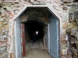
Ptarmigan Tunnel
Many Glacier, Glacier National Park
0.0 miles WA long hike to a hand-carved 240-foot tunnel through the Ptarmigan Wall at Glacier National Park, opening to views of Seaward Mountain and Elizabeth Lake — open mid-July through early October.
Backpack, Hike 11.8 mi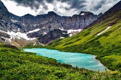
Cracker Lake Trail
Many Glacier, Glacier National Park
1.0 miles EA 12.5-mile hike through forests and meadows to a surreal turquoise lake in the Many Glacier area — plan for two days to fully enjoy this bear-country gem.
Backpack, Camp, Hike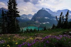
Grinnell Lake
Many Glacier, Glacier National Park
2.5 miles SWA 7.5-mile round-trip hike along glacier-fed subalpine lakes to a turquoise glacial lake in Glacier National Park — with a waterfall along the way and an optional ferry across Lake Josephine.
Hike, Swim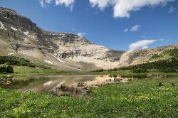
Siyeh Pass Trail
Logan Pass, Glacier National Park
6.7 miles SA top-of-the-world point-to-point hike through Glacier's Preston Park meadows to a high pass with glacier views, mountain goats, and bighorn sheep.
Backpack, Hike
Clements Mountain Trail
Logan Pass, Glacier National Park
7.3 miles SA four-mile round-trip climb of Clements Mountain in Glacier National Park, with several routes of varying difficulty and significant elevation gain — often confused with nearby Reynolds Mountain.
Backpack, Camp, Hike, Rock Climb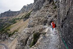
Highline Trail
Logan Pass, Glacier National Park
7.3 miles SOne of Glacier National Park's most celebrated hikes — the Highline Trail spans alpine meadows, the Continental Divide, and the Garden Wall with mountain goats, wildflowers, and views to rival anything in the park.
Backpack, Hike 5.0 mi
Hidden Lake
Glacier National Park
7.4 miles SA 6.6-mile round-trip hike from Logan Pass through alpine meadows, dense forest, and rocky terrain to the crystal-clear waters of Hidden Lake, with bighorn sheep and mountain goats along the way.
Hike 0.6 mi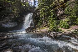
Baring Falls
Glacier National Park
9.1 miles SEA moderate trail hike in Glacier National Park to 30-foot Baring Falls dropping into crystal-clear water — with scenic mountain overlooks, wildlife, and an optional gorge viewpoint 1.5 miles beyond.
Hike 1.4-4.6 mi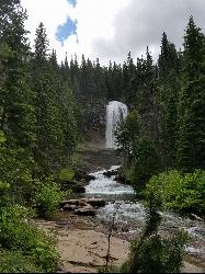
St Mary and Virginia Falls
Rising Sun, Glacier National Park
9.2 miles SA scenic 3.7-mile roundtrip hike past St. Mary Falls' 50-foot two-tiered drop to the upper and lower tiers of Virginia Falls, best in early season when snowmelt is rushing.
Hike 0.9 mi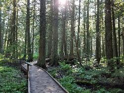
Trail of the Cedars
Apgar Village, Glacier National Park
10.4 miles SWAn easy wheelchair-accessible loop through towering 500-year-old cedars up to 100 feet tall in Glacier National Park, with gorge views of glacial Avalanche Creek and a footbridge over the water.
Hike 4.5 mi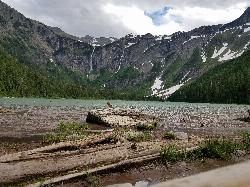
Avalanche Lake
Apgar Village, Glacier National Park
10.5 miles SWHike near Apgar Village, Glacier National Park
Hike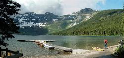
Cameron Lake
Waterton, Glacier National Park
22.5 miles NWA picturesque Canadian glacial lake in Waterton Lakes National Park surrounded by mountain scenery, avalanche-sculpted shores, kayaking, fishing, and Herbst Glacier views.
Backpack, Camp, Hike
Jewel Basin
Kalispell, Montana
44.9 miles SThe Jewel Basin Hiking Area packs 35 miles of hiker-only trail, two dozen alpine lakes, and the Mount Aeneas lookout into the Swan Range near Kalispell.
Backpack, Camp, HikeNearby Campsites
Many Glacier Campground
Many Glacier, Glacier National Park
0.2 miles SCamp near Many Glacier, Glacier National Park
Camp 11.8 mi
Cracker Lake Trail
Many Glacier, Glacier National Park
1.0 miles EA 12.5-mile hike through forests and meadows to a surreal turquoise lake in the Many Glacier area — plan for two days to fully enjoy this bear-country gem.
Backpack, Camp, Hike
Clements Mountain Trail
Logan Pass, Glacier National Park
7.3 miles SA four-mile round-trip climb of Clements Mountain in Glacier National Park, with several routes of varying difficulty and significant elevation gain — often confused with nearby Reynolds Mountain.
Backpack, Camp, Hike, Rock Climb
Rising Sun Campground
Glacier National Park
10.1 miles SEMore than 150 sites in eastern Glacier National Park close to Going-to-the-Sun Road, St. Mary's Falls and Red Rock Falls trails, and frequent bear, elk, and bighorn sightings.
Camp
Avalanche Campground
Glacier National Park
10.5 miles SWNestled on Glacier National Park's west side, Avalanche Campground puts 128 sites, flush toilets, and bear-proof storage right next to the Trail of the Cedars and the stunning Avalanche Lake hike.
Camp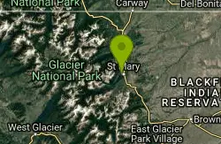
St. Mary Campground
Glacier National Park
11.1 miles EOver 200 campsites on the edge of Glacier National Park with flush toilets, showers, and quick access to Going-to-the-Sun Road, the Highline Trail, and St. Mary Lake.
Camp
Sprague Campground
Glacier National Park
16.3 miles SWAn 85-site campground on the west side of Glacier National Park near Lake McDonald, with swimming, boating, fishing, wildlife viewing, and the Trail of the Cedars nearby.
Camp
Cut Bank Campground
Glacier National Park
19.1 miles SEA peaceful forested campground along Cut Bank Creek in Glacier National Park with 48 first-come sites, nearby hiking trails, and access to fishing at St. Mary Lake.
Camp
Fish Creek Campground
Glacier National Park
22.3 miles SWA 193-site Glacier National Park campground along Fish Creek, surrounded by pine and cedar forest, with mountain views, fire rings, and access to the Trail of the Cedars nearby.
Camp
Cameron Lake
Waterton, Glacier National Park
22.5 miles NWA picturesque Canadian glacial lake in Waterton Lakes National Park surrounded by mountain scenery, avalanche-sculpted shores, kayaking, fishing, and Herbst Glacier views.
Backpack, Camp, Hike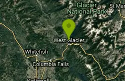
Apgar Campground
Apgar Village, Glacier National Park
23.5 miles SWCampsites on the shores of Lake McDonald within Glacier National Park, with easy access to the Apgar Visitor Center, nature center, nearby hiking, and the western entrance to Going-to-the-Sun Road.
Camp
Bowman Lake Campground
Glacier National Park
24.0 miles WA stunning lakeside campground in the heart of Glacier National Park with 50+ campsites, bear-proof lockers, nearby hiking trails, and access to swimming, fishing, and paddling on Bowman Lake.
Camp
Logging Creek Campground
Glacier National Park
24.5 miles WA first-come, first-served campground nestled in the Many Glacier area of Glacier National Park, with 49 sites and close access to the Grinnell Glacier and Swiftcurrent trails.
Camp
Kintla Campground
Glacier National Park
25.0 miles NWA 26-site campground on the shores of Kintla Lake inside Glacier National Park — fire pits, bear boxes, vault toilets, and the Kintla Lake Trail at your doorstep.
Camp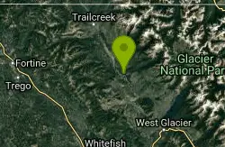
Quartz Creek Campground
Glacier National Park
25.5 miles WA peaceful 22-site campground in the heart of Glacier National Park, close to Going-to-the-Sun Road and a short hike from iconic Grinnell Glacier.
Camp
Two Medicine Campground
Glacier National Park
25.6 miles SECamp near Glacier National Park
Camp
Jewel Basin
Kalispell, Montana
44.9 miles SThe Jewel Basin Hiking Area packs 35 miles of hiker-only trail, two dozen alpine lakes, and the Mount Aeneas lookout into the Swan Range near Kalispell.
Backpack, Camp, Hike


