


28.4K IsaacSummer 2018 by endovereric
first prev 1 next last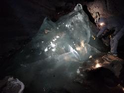
Rexburg Area Ice Caves
Rexburg, Idaho
29.1 miles N of Rexburg, IdahoNot to be mistaken with the Civil Defense Caves (which are near by), the Ice Caves are about an hour North outside of Rexburg. The Ice Caves were originally formed as lava tubes. The shape of the caves traps cold winter air in the cave and forms large areas of ice on the floor and beautiful ice crystals on the walls and ceiling. The ice remains frozen year round and makes for an awesome time. The ice caves are a few hundred yards deep and require good footwear, warm clothes and a flashlight to navigate. There is often a good amount of water near the entrance. There's a bridge of rocks across the area but you may get a little wet getting in the cave. There are areas where you'll need a rope to be able to ascend portions of ice. Please do not light fires or introduce any other heat source into the caves.

Sheep Falls on Henry's Fork
Island Park, Idaho
15.6 miles S of Island Park, IdahoSheep Falls is a beautiful, lesser-known waterfall on the Henry's Fork of the Snake River near Island Park, Idaho, where the river squeezes through a narrow basalt chute and drops about 25 feet in a churn of whitewater. It may be shorter than the famous Upper and Lower Mesa Falls just across the way, but it's every bit as scenic — and far quieter, making it a wonderful reward for a short, easy hike.
The trail to Sheep Falls is a gentle stroll of roughly a mile each way on a relatively well-maintained path, suitable for the whole family and rarely crowded. The route sits on the opposite side of the river from Mesa Falls, off Highway 20: head north past Ashton, turn onto Sheep Falls Road, and follow it to the trailhead — though be warned, the final dirt road is rough and rocky, so a high-clearance vehicle is a good idea.
There are calmer pockets near the falls where people wade and swim on hot summer days, but the water here deserves real respect. The current above and around the chute is powerful and can sweep you off your feet and pull you toward the drop. Stay well back from the lip, keep a close eye on children, and only consider getting in where the water is clearly calm and you know it's safe — when in doubt, enjoy the falls from the bank.
The best season runs roughly May through October, when the road is passable and the river is at its most beautiful. Bring sturdy shoes, water, and a camera, pack out everything you bring in, and you'll discover one of the Island Park area's most underrated natural treasures.
Fall Creek Falls
Swan Valley, Idaho
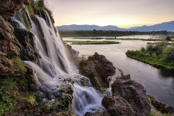
2.1 miles SW of Swan Valley, IdahoFall Creek Falls is one of eastern Idaho's most beloved and photographed waterfalls — a broad, 60-to-70-foot curtain of water that spills over mossy travertine ledges directly into the Snake River near Swan Valley. It's a genuinely unusual sight: most waterfalls tumble into a creek or pool, but this one pours straight into a major river, framed by the cottonwoods and canyon walls of the beautiful Swan Valley. It's especially glorious in autumn, when the riverside trees blaze gold and the whole scene lights up.
The best part for most visitors is how easy it is to reach. From Highway 26 just west of Swan Valley, turn onto gravel Fall Creek Road (Forest Road 058) and follow it along the Snake River to a small pull-out near the falls. From there it's more of a short walk than a hike — cross a small stream and stroll a couple of minutes to a flat perch right at the top of the falls, with sweeping views over the waterfall and the river beyond.
Adventurous visitors can scramble down for a closer look. A steep, sandy slide and a set of natural rock steps lead down toward the base, where you'll find a mossy grotto tucked behind and beneath the falls — a magical little chamber where you can stand in the cool mist and shade with the water curtaining down in front of you. The ceiling is low, so watch your head, and the rock steps kick up far less dust than the loose slide.
Be careful near the edges. The viewpoints at the top sit right above the falls, with abrupt, unrailed cliff drops of 10 to 15 feet in places, so keep well back from the lip and hold onto children — the rock can be slick near the water. The short scramble to the bottom is steep and can be slippery too.
The falls are a favorite of paddlers, too: because the water spills right into the Snake, kayakers and rafters floating this stretch below Palisades Dam can pull up close to the base for a view you can't get any other way. In winter the falls partially freeze into curtains and columns of ice, drawing photographers to the snowy canyon. However you come at it — on foot from the road above or by boat from the river below — it's a quick, high-reward stop between Idaho Falls and the Wyoming line.
The falls run year-round and reward a stop in any season, though flows are fullest with spring snowmelt and the color is best in fall. For photographers, midday sun is harsh out here; early morning or evening light is far kinder. Keep an eye on the river, too — boaters and rafters drift past below, and the area teems with wildlife, including the American white pelicans that cruise this stretch of the Snake. A Forest Service campground and public boat ramps sit nearby, making it easy to turn a quick stop into a longer stay. Bring water and sturdy shoes, and enjoy one of those “how have I never seen this before?” Idaho gems.

17 Mile Cave
Idaho Falls, Idaho
16.1 miles W of Idaho Falls, IdahoSeventeen Mile Cave is an easy, family-friendly lava tube out on the volcanic plain about 17 miles from Idaho Falls, Idaho — the source of its name. Formed by the flowing lava of the Snake River Plain's volcanic past, the tube was left hollow when the molten rock drained away, leaving a tunnel you can walk right into. Its easy access and gentle floor make it one of the most popular beginner caves in eastern Idaho, drawing spelunkers from Idaho Falls and Rexburg alike.
The entrance sits just a few hundred feet from the highway, and the cave runs a little less than a quarter mile back. What sets Seventeen Mile Cave apart from most lava tubes is its floor: instead of the usual jumble of collapsed rock, much of it is smooth and nearly flat, which makes walking the length of the cave surprisingly easy. There's one main tunnel that's simple to follow — no real chance of getting lost — making it a great first caving trip for kids and newcomers.
At the far end, the quarter-mile passage finishes at a pair of small pools and a swampy area; it's difficult to push much beyond this point, so most explorers turn around here. Along the way, the cave stays cool and humid year-round no matter how hot the desert above, so it's a refreshing escape on a summer day — and a genuinely chilly one in the shoulder seasons.
Come prepared with the caving basics: bring at least two light sources per person (the cave is completely unlit), wear a jacket or extra layer for the cool interior, and put on sturdy, closed-toe shoes, since the floor is damp and can be slick near the pools. It's a short trip, but a headlamp that frees your hands makes it far more enjoyable.
The cave is one of many volcanic features scattered across this stretch of the Snake River Plain, a landscape built by ancient eruptions and riddled with tubes, cracks, and cinder cones. That makes it a natural first stop for local families and Scout groups getting into caving, and an easy add-on to a day of exploring the wider volcanic country around Idaho Falls. Bring a group — caves are always more fun, and safer, with company — and let someone know where you're headed.
One honest note: because it's so close to town and so easy to reach, Seventeen Mile Cave gets heavy traffic, and it shows — the walls carry a lot of graffiti and the floor collects litter. Do the cave a favor by packing out everything you bring (and maybe a bit extra), skipping the spray paint, and treating the place with respect, so this accessible little lava tube stays a fun introduction to caving for the next family that comes to explore.
Bitch Creek Trestle
Tetonia, Idaho
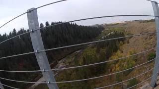
9.4 miles N of Tetonia, IdahoThe Bitch Creek Trestle is the dramatic centerpiece of the Ashton to Tetonia Trail, a historic railroad bridge that carries walkers, cyclists and horseback riders some 135 feet above the valley floor in the rolling farm country of eastern Idaho's Teton Valley near Tetonia. Built in 1923 for the Teton Valley Branch of the Union Pacific Railroad and now repurposed as a recreation crossing, it's one of the most popular and photogenic features on the whole trail, delivering a genuine thrill and sweeping views of the creek far below and the Teton Range beyond.
The trestle is part of the Ashton to Tetonia Trailway State Park, a 29.6-mile rail trail that follows the abandoned grade of the old railroad. When the rail line was permanently abandoned, the Idaho Department of Parks and Recreation recognized that the gentle, scenic railroad grade would make an excellent trail, and it opened to the public in 2010. Along its 30 miles it crosses three historic railroad bridges, the Bitch Creek Trestle, the Conant Creek Trestle and the Fall River Trestle, with Bitch Creek the star of the trio.
What makes the trail so appealing is its easy grade and its views. Because it follows a railroad bed, the climbing is gentle and steady rather than steep, which makes it approachable for families, casual cyclists and horseback riders alike, all while serving up stunning views of the Tetons across the valley. The trestle itself is the highlight, a high, airy crossing that rewards the ride with a look straight down into the Bitch Creek gorge.
Unlike many state parks, the Ashton to Tetonia Trail is free of charge, which makes it an easy, low-commitment outing. In winter, the same grade becomes a groomed cross-country ski and snow route in sections, extending its use across the seasons.
The trestle is high and open, so anyone uneasy with heights should know that going in, and the trail surface is old railroad grade, generally good but with loose spots, so appropriate footwear or tires help. Sun exposure is real on the open farm-country stretches.
Late spring through fall is prime for hiking and biking, with the wildflowers and green fields of early summer and the golden light of autumn both worth timing for; winter opens the Nordic use. Bring water, sun protection, and a camera, since the trestle is a genuinely spectacular photo spot. For an easy, scenic, historic ride or walk with a heart-in-your-throat crossing at its center, the Bitch Creek Trestle is one of eastern Idaho's best.
Twin Bridges
St. Anthony, Idaho
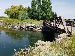
6.6 miles NE of St. Anthony, IdahoTwin Bridges is a beloved bridge-jumping and swimming spot on the river near St. Anthony, Idaho — a summer institution for families, teens, and college students across the upper Snake River Valley. The name comes from the setup: an old abandoned bridge stands right beside the one still in use, and the deep, slow water beneath the old span makes for about the best bridge jumping around, with no traffic to dodge and easy parking nearby.
The jumping is the main event, and it's well suited to a range of nerve. There are two distinct levels to leap from — a lower point around 11 feet and a higher one around 17 feet — so you can start small and work your way up, and the water below is plenty deep for cannonballs, flips, and gainers. Locals consider it about as good and as “reasonably safe” as bridge jumping gets, with one firm caveat: keep clear of the rocks along the sides, which can be exposed depending on the water level.
There's more to it than jumping. A little rope swing often hangs under the bridge — a favorite of the little kids — and a path up the river makes a good put-in for a short, mellow float back down. For families with young children, there's a sandbar on the north side just upstream of the action, perfect for wading and splashing away from the jumpers. The slow current is ideal for simply hanging out in the water while you watch your friends show off.
A fun local curiosity: downstream of the little rock dam on the north side lie the sunken remains of an old car, washed here after an accident years ago. When the water is low and clear you can spot its chrome bumper from the rocks and swim down for a look — a quirky bit of underwater sightseeing that regulars love.
Part of the appeal is how welcoming and community-minded the spot is. Generations of upper-valley families and Rexburg-area college students have made Twin Bridges their go-to summer swimming hole, and there's a friendly, everybody-shares-the-water vibe on a busy afternoon. It's the kind of simple, free, small-town summer pleasure that keeps people coming back week after week.
A few practical notes: it's a popular place, so expect a crowd on hot, sunny days and holidays — though it handles a lot of people well, and you rarely wait long to jump. Bring water shoes for the rocky spots, sun protection, and drinking water, always check the water depth and clear your landing before jumping (levels change through the season), keep an eye on kids near the current, and pack out all your trash. For a classic, easygoing eastern-Idaho swimming hole, Twin Bridges is hard to beat.

Mount Timpanogas
Provo, Utah
13.7 miles N of Provo, UtahMt. Timp, as the locals call it, is the 2nd highest mountain in the Wasatch range (only Mt. Nebo is higher). What sets "Timp" apart is its location. It towers over the Provo, Orem, Pleasant Grove area and its a very dominant feature. It rises 7000 feet from the valley floor and draws your gaze to it again and again.This mountain may be the most popular one in the state of Utah and is certainly the most climbed. Mt. Timpanogos is a huge mountain, extending almost seven miles in a north to south direction with many of its peaks reaching over the 11000 foot mark.


