


Refine Search
- hike 24
- swim 10
- kayak 3
- canoe 2
- mountain bike 2
- snowshoe 1
- sled 1
- cross-country ski 1
- dive 1
- disc golf 1
- camp 1
- rock climb 1
28 locations
Add Location
 Full Listing
Hike
Added on 19 Jul 2017
Full Listing
Hike
Added on 19 Jul 2017
 Full Listing
Hike
Added on 19 Jul 2017
Full Listing
Hike
Added on 19 Jul 2017
 Full Listing
Hike, Swim
Added on 15 Jul 2017
Full Listing
Hike, Swim
Added on 15 Jul 2017
 Full Listing
Cross-country Ski, Hike, Sled, Snowshoe
Added on 14 Jul 2017
Full Listing
Cross-country Ski, Hike, Sled, Snowshoe
Added on 14 Jul 2017
 Full Listing
Hike
Added on 14 Jul 2017
Full Listing
Hike
Added on 14 Jul 2017
 Full Listing
Hike
Added on 7 Jul 2017
Full Listing
Hike
Added on 7 Jul 2017
 Full Listing
Hike
Added on 28 Jun 2017
Full Listing
Hike
Added on 28 Jun 2017
 Full Listing
Hike
Added on 28 Jun 2017
Full Listing
Hike
Added on 28 Jun 2017
 Full Listing
Hike, Swim
Added on 26 Jun 2017
Full Listing
Hike, Swim
Added on 26 Jun 2017
 Full Listing
Hike, Kayak, Mountain Bike, Rock Climb, Swim
Added on 26 Jun 2017
Full Listing
Hike, Kayak, Mountain Bike, Rock Climb, Swim
Added on 26 Jun 2017
 Full Listing
Hike, Swim
Added on 21 Jun 2017
Full Listing
Hike, Swim
Added on 21 Jun 2017
 Full Listing
Hike
Added on 14 Jun 2017
Full Listing
Hike
Added on 14 Jun 2017

 Full Listing
Hike
Added on 17 May 2017
Full Listing
Hike
Added on 17 May 2017
 Full Listing
Hike
Added on 17 May 2017
Full Listing
Hike
Added on 17 May 2017
 Full Listing
Kayak, Swim
Added on 16 May 2017
Full Listing
Kayak, Swim
Added on 16 May 2017

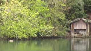
Drift Creek Falls
Otis, Oregon
7.6 miles SE of Otis, OregonHike this unique trail where you have the opportunity to walk on a 240-foot long cable suspension bridge! From the bridge, you will be able to see marvelous views of Drift Creek Falls below you! Located in Siuslaw National Forest in Lincoln City, this hike is a MUST! The beginning of the hike is almost nearly all downhill and all uphill in return. The scenery is mainly all trees, but don't let that discourage you from hiking this awesome trail through a beautiful 50-year old regrowth forest. The trail is wide and well-maintained. You will cross a couple of small bridges over some streams before you reach the suspension bridge. The trail continues on to the bottom of the falls after you've crossed it. There's a safe area for kids to wade and play in the creek as well. It's important to be careful on this hike, especially during rainy weather. The trail and the bridges can become quite slippery.
This hike is great for all ages and will provide something interesting for both young and old!
NOTE: You have to pay a $5 fee to get into the park.
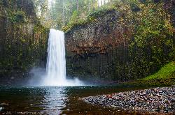
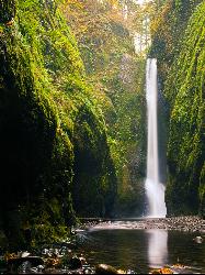
Abiqua Falls
Scotts Mills, Oregon
9.2 miles SE of Scotts Mills, OregonThis rough hiking trail will be well worth your effort and time. Although the trail is unmarked, there is a rope to steady yourself on the steep parts of the hike and guide you through the forest. Don't rely on your GPS to get you to the waterfall because you likely won't have cell reception. The waterfall is located on private land but is currently available to visitors who take the "trail". Finding the trailhead may be a bit problematic and will take a bit of off-roading to find, so again, don't completely rely on your GPS to find it for you. If you see a white sign on a tree or some arrows carved into a tree, you're going the right way.
This is a very steep hiking trail and becomes very slick, especially in the colder and rainier months. Some areas are very rocky and will require you to climb over big rocks and a few fallen trees. The trail ends at a basalt bowl with the breathtaking Abiqua Falls plunging into it. This is a hidden gem that is similar to the fall formations at Silver Falls State Park. Many people love taking pictures of this beautiful area. Facing the 92-foot waterfall, you will feel as if you are enclosed in a deep, mossy canyon. Also, if it's warm enough, people wade into the chilly water and get closer to the falls. Depending on the time of year, the water can be deep enough to swim in.
It is not recommended to bring small children or dogs on this hike because the climb back up is very steep and is difficult enough for the average person to just pull themselves up the ascent by the ropes.
Due to the difficulty of this hike, the fantastic destination at the end will surely feel very rewarding!
Oswald West State Park
Arch Cape, Oregon
3.7 miles S of Arch Cape, OregonThis 2,484-acre state park is located just two hours west of Portland and provides numerous hiking and surfing opportunities. It's also home to one of the better beaches along the Oregon Coast with a secluded sandy beach. It's called Short Sands beach but the locals call it "Shorty's". There are miles and miles of trails through the amazing rainforest that is Oswald West State Park. These trails offer gorgeous scenery of the forest and the Pacific Ocean. If you want a break from hiking, walk down to the beach and explore the amazing tide pools where you'll find neat little sea creatures hiding.This is a great place for anyone young or old to explore!
If hiking isn't your thing, surfing is a common activity many locals and visitors enjoy. Although this part of the coast isn't as well-known like other areas, it is still teeming with activity and can be quite busy during the summer and especially on weekends. This beach has exposed beach break and reliable and consistent waves any time of the year making this an ideal surfing destination. You will likely see many people in wetsuits carrying their surfboards down to the beach to catch the next big wave.
NOTE: Watch out for dangerous rip tides and make sure you know how to spot them.
Hurricane Ridge
Port Angeles, Washington
10.7 miles S of Port Angeles, WashingtonHurricane Ridge is a mountain area in Olympic National Park in Washington 17 miles south of Port Angeles. It's about a mile high and offers gorgeous views that can be enjoyed throughout the year whether it be fall, winter, spring, or summer! Hurricane Ridge offers a great variety of hiking trails and excellent areas for skiing, snowboarding, and snowshoeing. There are walking trails near and around the visitors center which is where the park recommends you start. An orientation movie and informative videos can be viewed at the visitors center for those who would like to learn more about the area. Restrooms, an information desk, gift shop, and snack bar are also located here. The gift shop offers ski and snowshoe rentals during the winter.
The Hurricane Hill trail is a popular hike during warmer months that most visitors take so they can see the beautiful panoramic view at the top. The view is best on a very clear day. You will be among the tall, snow-capped mountain peaks and have wonderful 360-degree views of Puget Sound, the Olympic Range, and Vancouver Island as well as parts of Canada! In the prime summer months, wildflowers are in full bloom all around you. You most likely will see a lot of wildlife during your trip. Deer, marmots, ground squirrels, chipmunks, mountain goats, and even black bears are common sights by visitors. Be careful not to leave your backpack unattended because the chipmunks and ground squirrels are known to climb into them. Marmots are frequently seen and heard in this area so make sure to listen for the whistle of the marmot. Whistle to them and they will whistle back to you.
Although the hike is not incredibly difficult, you do need a fair amount of stamina to hike this out and back trail. The Hurricane Hill trail begins 1.5 miles beyond the visitors center at the end of the road. The trail has a slight incline the whole way to the top so you do get a fair amount of elevation gain. You won't regret taking this hike once you see the spectacular views.
Hurricane Ridge also has a ski and snowboard area that's fantastic for the outdoor winter enthusiast! Hurricane Ridge Ski and Snowboard Area is one of the two currently operating ski lifts in the National Parks. This area is perfect for all your winter recreation needs! The average snowfall per year is 400 inches. The summit elevation is 5,240 feet.
Skyscraper Mountain Trail
Ashford, Washington
19.6 miles NE of Ashford, WashingtonLocated in Mount Rainier National Park, Skyscraper Mountain measures at about 7,078 feet and towers over the valleys and streams below. The entire hike offers magnificent mountain views and only gets better as you go! The trail has a few ups and downs along the way but has a steady incline at about 3.4 miles. The ascent to the summit is the most difficult part of this hike and may require some scrambling. At 3.6 miles you get to the pass which is a popular place to rest and take in the unobstructed views of the Cascade Range. The summit itself is rocky, exposed, and fairly small. Looking southwest you will see incredible sights of Mount Rainier and to the west, you will enjoy amazing vistas of Moraine Peak and Mystic Lake!
You can turn around and scramble back down the mountain the way you came, or you can switch it up if you'd like and take a different trail back down to the base of Skyscraper Mountain.
This is a gorgeous day hike that anyone in the Mount Rainier area should experience.
NOTE: The network of trails around the Sunrise trail can be quite confusing, but you will also find peace and solace in this area no matter what trail you take.
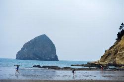
Cape Kiwanda
Pacific City, Oregon
1.3 miles NW of Pacific City, OregonCape Kiwanda is a state natural area in Pacific City, Oregon. This is a fantastic place to spend an entire afternoon! You will see magnificent views of the basalt monolith officially called, Chief Kiawanda Rock. It is commonly misnamed as the "other haystack rock" and is 90-feet higher than Haystack Rock in Cannon Beach. The basalt stack got its name from a leader for the Nestucca Indian tribe. You will also see some impressive dunes and remarkable sandstone. At low tide, you can explore the sandstone at the base of the cliffs and search for fossils. The sandstone still remains due to the protection that Chief Kiawanda rock provides against the immense waves of the ocean. The Cape Kiwanda hike begins at the Pacific Avenue trailhead which is about a mile down from the cape itself. Walking along the beach you will enjoy views of the incredible monolith and the beautiful scene of the cape ahead of you. You will probably see surfers in wetsuits and some occasional kayakers. Pacific City is one of the most popular places to surf on the Oregon Coast because of its consistency.
Once you get to the base of the dune, there are two routes you can go. The lower route, and the way up the Great Dune. If you decide to hike up the Great Dune first, you can make a loop hike out of it because you can circle around the Sitka spruce trees and make your way to the lower dune by a trail through the trees once you're at the top. The lower dune goes out to the edge of the cape and provides gorgeous views of the opposite side of Cape Kiwanda. To your right, you'll be able to see Nestucca Bay. There are fences and signs that discourage visitors from getting too close to the edge of the cape due to soft cliff edges crumbling or falling off. This can happen at any time, so it's important to be careful.
You can take the trail down the lower dune to the base of Cape Kiwanda, or you can turn back and run or slide down the Great Dune. It's a very popular sandboarding or "sand sledding" spot.
Climbing up the Great Dune is somewhat of a workout. You will definitely feel the burn in your legs halfway to the top. This climb can be done with children. but they may require some assistance due to the strenuous hiking. You won't make much progress just using your feet to walk up, so it's a bit faster and easier if you use your hands and crawl up the dune. It's difficult, but definitely worth it once you reach the top!
NOTE: One of the downsides of the Cape Kiwanda area and Pacific City is that it is typically very busy and crowded.
Whiskeytown Falls
French Gulch, California
4.7 miles SW of French Gulch, CaliforniaWhiskeytown Falls trail is located within Whiskeytown State Park just about 15 miles outside of Redding. The state park has a lot of activities to do, but it is also home to one of the "best waterfalls in Northern California". It's at the west end of the lake about 9-miles from the visitor's center.
The hike is about 1.7 miles each way and is uphill for a majority of the hike so this hike will take a bit longer than you might anticipate.
NOTE: Make sure to bring enough water with you as this hike can be fairly strenuous, especially on a hot day.
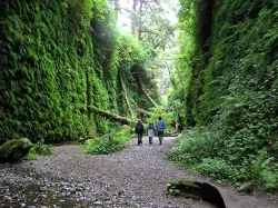
Fern Canyon
Orick, California
7.9 miles N of Orick, CaliforniaFern Canyon is one of the best 1-mile hikes that you can do in California! This unforgettable location was featured in Steven Spielberg's film, Jurassic Park: The Lost World.
Fern Canyon is located in Prairie Creek Redwoods. It's not incredibly easy to find, but the remote 8-mile drive will be worth seeing this fern laden paradise. Two stream crossings will need to be done by car, but one of these streams can be about 6 inches deep. If you don't think your car can make it, you'll just have to park and walk an extra mile.
Since this drive is pretty much in the middle of nowhere, you may see a lot of wildlife. You will most likely see a lot of elk on this drive so it's important to drive slowly on the dirt road. Also be aware of potholes along the road.
The drive is the most difficult part of this trip, so the hike is going to be a piece of cake in comparison. There is a parking lot with a vault toilet and a sign giving information about the area. The level trail begins at the top of the parking lot and leads you through a small, moss-covered forest before you reach the canyon. Be prepared to get wet during your hike because you will have to cross more streams. Don't try to find a way around the water and just have fun with it. Since the trail is relatively flat, this hike is a perfect, fun adventure for those with small children. There are a few wooden foot bridges here and there to cross some of the streams, but it is probable you will get your feet wet at some point.
Once you reach the canyon, you will have 50-foot canyon walls towering over you. These walls have lush, green plants cascading down the sides and there are fallen redwood trees, green with moss. You will possibly have to climb over or under a few logs. Along the canyon walls, there are some little waterfalls and streams that trickle down through the foliage. You will feel as if you are walking through a rainforest in Fern Canyon. No wonder a scene from the Jurassic Park movie was filmed here!
Going through the canyon itself is only about a half a mile, but the trail continues on and flattens out again into a forest. You can hike the whole loop trail or you can go back the way you came if you want to experience the canyon again (who wouldn't?).
Make sure you add this magical place to your list of places to see!
NOTE: Leave early in the morning to avoid the crowds. Bring water shoes or sandals.
Desoto Falls
Mentone, Alabama
2.1 miles S of Mentone, AlabamaIf you visit Desoto State Park, this is one of the must-see sights! Desoto Falls is rich in history and legends. It's a scenic beauty located within Desoto State Park and is easily accessible from Lookout Mountain Parkway.
Desoto Falls is the tallest and most popular waterfall in Alabama and was named after a Spanish explorer, Hernando De Soto. The 104-foot waterfall has formed its own small canyon, although it is believed that parts of the falls are manmade. There are also legends about the caves that are found around the falls. It has been said that a piece of Hernando De Soto's armor from his 1500's expedition was found near the falls. For thousands of years, De Soto Falls has been a landmark, especially visited by Native Americans long before the first European explorers arrived. The waterfall was special to the Cherokee Indians who once lived in this area of Alabama
If legends are true, De Soto was here before Columbus came to America. Local folklore has it that a few of the small caves below the waterfall were part of a fort built by Welsh explorers, but research findings say that it was probably a structure built by American Indians in the Woodland era.
The upper falls can be seen by all visitors from the railed overlook near the parking lot. To see the lower falls, you need to walk down cement steps which could be difficult for young children and the elderly.
The amount of water rushing from the falls depends on how much rainfall there has been. In the winter and early spring, the water levels are high, while water levels are very low during the summer and early fall.
Desoto State Park
Fort Payne, Alabama
6.7 miles NE of Fort Payne, AlabamaDesoto State Park is located on the gorgeous Lookout Mountain in the scenic northeast of Alabama. It is conveniently located 8 miles northeast from Fort Payne. With many rushing waterfalls and fragrant wildflowers scattered throughout the park, visiting this state park will be a breathtaking experience.
There is a myriad of amenities at the park which includes, a restaurant, meeting rooms, pavilions, a picnic area with a playground, an Olympic-size swimming pool, and a nature center which feature interpretive programs and live animals. You can take further advantage of these amenities by staying a few nights in the chalets, rustic cabins, motel rooms, or the campground containing 94 sites with full RV hookups.
This family-friendly park has many activities to keep everyone of all ages entertained. Whether you're an outdoor enthusiast or a sports fanatic, you'll enjoy many of the opportunities that Desoto State Park has to offer. Kayaking, fishing, hiking, cycling, mountain biking, rappelling, bouldering, picnicking, and camping are many of the wonderful activities you can enjoy here. This is the perfect place to get out into nature and go on a wildflower expedition or just go exploring for the fun of it!
Oneonta Gorge
Cascade Locks, Oregon
10.5 miles SW of Cascade Locks, OregonThis unique hike is one of the many incredible experiences you can have in Oregon! It is located near Horsetail Falls which is another great hike to add on to this one if you would prefer a more lengthy outdoor excursion. You will definitely want to bring some water sandals and maybe an extra set of clothes for this adventure!
As soon as you reach the "trailhead" you will soon figure out that there isn't a designated trail for this hike. You will be required to climb over a log jam, tread through chest deep water (which can be quite cold at times), and hike through a narrow canyon over loose river rock and smooth pebbles covering the creek bed. Once you are in the gorge and see the moss and lichen covered rock towering above you, you'll feel as if you have gone to another world. There is something so surreal about walking through this mossy, green slot canyon adorned with ferns. It's like looking at a scene from a movie.
This hike is not for the faint of heart due to it being a bit challenging and strenuous. You won't be able to avoid getting wet during this hike and the water is typically fairly chilly!
It is also advised that you don't bring along small children unless you plan on carrying them. This would not be considered a family friendly hike.
NOTE: Depending on the time of year and your height, the water could be deeper or shallower than stated in the description.
TIP: To avoid the crowds, go sometime during the week rather than on the weekends. Going in the morning could also help you to avoid the rush of people who go later in the day when it gets warmer.
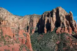
Brins Mesa Trail
Sedona, Arizona
4.2 miles NW of Sedona, ArizonaBrins Mesa Trail is located in the Coconino National Forest just at the edge of the town of Sedona. This trail will provide picturesque views of the gorgeous, geological landscape. Brins Mesa Trail is as convenient as it is beautiful! You will walk among amazing red rock towers and formations, as well as witness the beauty of an Arizona desert.
This trail is unique in the way that it doesn't keep you secluded in a canyon or keep you strictly to the edge of a slope like many of the other trails in the area. Brins Mesa will lead you to an open area of the desert where you can enjoy unobstructed views of the incredible red rock and sandstone!
The hike isn't very steep or very long but it can be intensely hot in the summer. Although if you can endure the heat, the views will be completely worth it!
*NOTE: Make sure to bring a lot of water with you for any hike in a hot climate. Also be sure to check for heat warnings before you go!
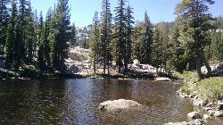
Shirley Canyon
Olympic Valley, California
1.0 miles NW of Olympic Valley, CaliforniaHike near Olympic Valley, California
Full Listing
Hike
Added on 22 May 2017
4.1 mi
 Full Listing
Hike, Swim
Added on 22 May 2017
Full Listing
Hike, Swim
Added on 22 May 2017
Shirley Lake Canyon Trail
Olympic Valley, California
0.3 miles W of Olympic Valley, CaliforniaShirley Lake is a pretty and pure lake located in Squaw Valley. The Shirley Lake Canyon Trail goes up into the rugged and lovely Sierra Mountains. You begin the trail in Squaw Valley Village and you keep hiking along streams and waterfalls. As you near Shirley Lake, the trail has some steep and rocky sections and gains a moderate incline. The trail can be fairly difficult to follow since it is poorly marked, so make sure to always keep the creek to your right and follow it for 2.5 miles until you come to large granite boulders. You will have to climb over some rock slabs to get to Shirley Lake. Once you get to the lake, you can choose to jump in for a dip or continue hiking to High Camp. The trail will get steep from there and is a gravel path. If you can make it to the top of High Camp, there is a gondola that you can ride back down for free. There is also an observation deck at the top so you can rest and take in the incredible views.
Unfortunately, if it is a really dry season, the waterfalls and streams may be dried up.
It's 4.1 miles to High Camp.
NOTE: Make sure to bring enough water for this hike.
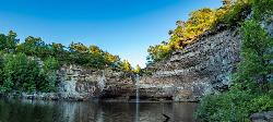
Tamolitch (Blue) Pool
Mount Washington, Oregon
9.4 miles W of Mount Washington, OregonThe Tamolitch Pool, also known as the Blue Pool, is the one and only pool of its kind in Oregon. The name "Tamolitch", meaning 'bucket', was given to this gorgeous basin by the Northwest Indians. This pool is created by the Mckenzie River which seeps through underground lava fields for two miles before emerging to the surface. As the river water seeps up from the porous lava, it gives the water in the pool a unique turquoise color and amazing clarity! This mesmerizing, clear blue water attracts many hikers, mountain bikers, and photographers. Despite the water that gushes out of the pool and returns to the Mckenzie River, the pool is so still and calm that it gives the illusion of a glass surface. This pool has become a popular place for photographers of all skill levels. It has gotten more recognition because of exposure on social media from visitors. The Tamolitch and McKenzie River trail are heavily used and have gained more and more visitors over the last few years.
It is not against the rules to jump into Tamolitch Pool. However, extreme caution is advised. Due to the clarity of the pool, those who jump in cannot make an accurate estimate of where the shallow areas are. The steep cliffs that surround the basin range from 10 - 60 feet. The water stays a chilly 30-some degrees all year round. Please jump from the cliffs at your own discretion.
The McKenzie River Trail is 26 miles if you hike the entire trail. To get to the "Blue Pool" is about 2 miles from the Tamolitch trail head. This hike is very scenic with great views of the McKenzie River with many photo opportunities along the way. The hike to Tamolitch is relatively easy with a well-maintained trail. The first part of the hike will be fairly flat but gets very rocky and a bit more steep the further you go. You will be able to see stunning views of the river from above as you hike.
Once you get to the pool, you can stand at the top of the cliffs and look down into the blue basin, or you can clamber down the steep lava rocks to the edge of the pool. On the other side of the pool, there is a way to get to the water's edge that isn't as steep.
NOTE: Although people do jump into the pool, it can be very risky. Many people have been injured and a few have even died by jumping in.
To the pool: about 2 miles
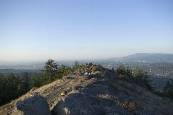
Spencer Butte
Eugene, Oregon
4.8 miles S of Eugene, OregonIn need of a nearby hiking fix? Spencer Butte is the perfect place to get away from the city of Eugene and into the forest. Spencer Butte is a prominent landmark in Lane County, Oregon. It is considered Eugene's "backyard hike" because of how close and central it is. Walking through tall douglas firs and the maple trees, you will feel far from civilization - at least until you reach the summit. From the summit, you can see the city of Eugene below. This is a great location to watch the sunrise or sunset.
There are many different trails to take at Spencer Butte but most of them interconnect. Most of these are loop trails. The trails range from easy to moderate and are considered family friendly. Many locals use these trails for morning hikes or trail running.
When the weather is nice Spencer Butte can get pretty crowded, but it is also a nice hike in rainy weather. Just be careful because it can get fairly muddy.
NOTE: Watch out for poison oak and rattlesnakes.
Round trip: about 2 hours - it depends on which trailhead you start at, but expect about an hour to the top of the summit and an hour down.
Elevation gain: about 721 feet
Limestone Parkway
Brierfield, Alabama
5.2 miles W of Brierfield, AlabamaCanoe, Kayak, and Swim near Brierfield, Alabama
Full Listing
Canoe, Kayak, Swim
Added on 16 May 2017
Kinlock Falls
Haleyville, Alabama
8.8 miles NE of Haleyville, AlabamaKinlock Falls in Bankhead National Forest is a favorite hangout spot among locals. It's a great place to hang out for a hot afternoon! Visitors can go down the falls on their kayaks and jump from various rock ledges into the pool below. It is well known for being a "water slide". *Take caution where the shallow areas are before jumping in* The rocks can be slippery so be careful when walking on the wet surfaces.
This is a moderately trafficked area due to how close it is to the road. It's just a short hike to the falls and swimming area from the road. It is advised not to go swimming here after a rainstorm as it can be quite dangerous.
NOTE: Watch out for venomous snakes in the area. There is also no cell coverage at this location.
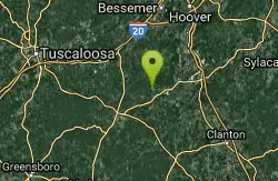
Cahaba River Trail
Birmingham, Alabama
8.7 miles E of Birmingham, AlabamaCanoe and Swim near Birmingham, Alabama
Full Listing
Canoe, Swim
Added on 15 May 2017
2.4 mi
 Full Listing
Hike
Added on 15 May 2017
Full Listing
Hike
Added on 15 May 2017
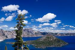
Wizard Island Summit Trail
Crater Lake National Park
4.6 miles N of Crater Lake National ParkWizard Island is one of the most interesting features of Crater Lake itself! It's considered one of the most magnificent volcanic cinder cones in the world. Take a boat tour to the island and experience its grandeur while hiking the Wizard Island Summit Trail! At the top, you will find the crater named Witches Cauldron.
Created by a violent eruption of Mount Mazama about 7,700 years ago, Wizard Island is located at the west end of Crater Lake. Although there are other cinder cones in the lake, Wizard Island is the only one to reach above the surface. The island rises about 755-feet above the lake.
The only way to get to the island is to hike down the Cleetwood Cove trail to the dock for boat tours. It's a 45-minute boat ride to Wizard Island where the trail to the summit begins. The beginning of the trail is very rocky with lava rock, but after about 10 minutes, the trail smooths out. The hike is about 2.5 miles total, which takes you around the 400-foot wide crater at the top.
Round trip: 4.5 miles
Elevation gain: about 765-feet
NOTE: There is a fee for the boat tour.
×


