


Refine Search
- hike 8
- camp 5
- swim 4
- dive 3
- airsoft 1
- paintball 1
- rock climb 1
- cave 1
- backpack 1
- canoe 1
- disc golf 1
- horseback 1
- mountain bike 1
14 locations
Add Location
 Full Listing
Show more
Camp, Hike, Horseback
Last visited on 1 May 2017
Full Listing
Show more
Camp, Hike, Horseback
Last visited on 1 May 2017
 Full Listing
Show more
Airsoft, Paintball
Last visited on 13 Apr 2017
Full Listing
Show more
Airsoft, Paintball
Last visited on 13 Apr 2017
 Full Listing
Show more
Camp, Canoe, Dive, Swim
Last visited on 13 Apr 2017
Full Listing
Show more
Camp, Canoe, Dive, Swim
Last visited on 13 Apr 2017
 Full Listing
Show more
Dive, Swim
Last visited on 13 Apr 2017
Full Listing
Show more
Dive, Swim
Last visited on 13 Apr 2017
 Full Listing
Show more
Dive, Swim
Last visited on 1 Aug 2016
Full Listing
Show more
Dive, Swim
Last visited on 1 Aug 2016
 Full Listing
Show more
Camp, Hike
Last visited on 13 Apr 2015
Full Listing
Show more
Camp, Hike
Last visited on 13 Apr 2015
 Full Listing
Show more
Camp, Hike
Last visited on 13 Apr 2015
Full Listing
Show more
Camp, Hike
Last visited on 13 Apr 2015
 Full Listing
Show more
Hike, Swim
Last visited on 12 Apr 2015
Full Listing
Show more
Hike, Swim
Last visited on 12 Apr 2015
Pine Butte / The Caldera
St. Anthony, Idaho
21.7 miles N of St. Anthony, IdahoThis is about as close to an oasis as you can get in the deserts of Idaho. It's an old volcano in the middle of the sagebrush desert. As soon as you start down the path, you can feel the air change and the vegetation becomes that of a mountain forest. There are a ton of pine trees on the hillsides and a beautfiul meadow at the bottom surrounded by thick aspen trees. The bottom part of the sides nearly all the way around is covered with large boulders great for a little rock hiking if you care to explore. The path in is about as easy a hike as it gets. Maybe a little steep at points but it's only about a quarter mile down in. It's pretty small and there's a pretty established place for fires with plenty of dead wood scattered around.
Ashton Hill
Ashton, Idaho
6.7 miles N of Ashton, IdahoFairly thick forest. Considerable underbrush. Lots of places in the area to play.
6.2 mi
 Full Listing
Show more
Backpack, Cave, Hike, Rock Climb
Last visited on 13 Apr 2017
Full Listing
Show more
Backpack, Cave, Hike, Rock Climb
Last visited on 13 Apr 2017
Darby Wind Cave
Driggs, Idaho
7.6 miles E of Driggs, IdahoDarby Wind Cave is a beautiful hike full of waterfalls, wildflowers, streams, and mountainous views. The sites you see will depend on the time of year you visit but it will always be beautiful and just a little bit of a challenge.
The trail starts out relatively flat, following along close to where the old road used to run. There are a few creek crossings which will vary in difficulty depending on how much snow there was over the winter and how long it's been since things began to thaw. Late summer will usually find you crossing dry or nearly dry creek beds. If you hike when runoff is high, there are log bridges. You don't have to be highwire ready but one of the bridges will take a little bit of balance. The trail turns up South up into the canyon. About as soon as it starts to go up, you'll turn and begin a series of switchbacks (10 turns). These will take you up the East wall of the canyon.
The switchbacks are not incredibly steep but you'll gain elevation pretty quickly. After the switchback, the trail follows along a rim above the canyon where you can look across the canyon and see two beautiful waterfalls and mouth of the cave seemingly high overhead. At the South end of the canyon, you'll come across a rock overhang. It's fun at any time during the summer but earlier when the water is higher, you'll find a little waterfall and stream that the kids will love to play in and you'll be hard pressed not to soak your head and feet and cool off a bit yourself.
From the the overhang, the hike continues West along the South end of the canyon through some more forest and a beautiful meadow. Take a minute to look up from the trail to enjoy the view of Fossil Peak to the South. Just after the meadow, you'll begin another series of switchbacks up to the falls and cave. The first set (2 turns) will take you up to a dispersed campsite and monument. The next leg will take you to the creek where you can look up and get photos of the falls and cave. The next set puts you out just underneath a very large and beautiful waterfall that drops out over a ledge. The ledge itself is a popular repel accessible from above. You can walk all the way around these falls and even catch some spray on the downwind side. The next set of switchbacks are stairs cut out of the rock. Halfway will take you to an even better view of Fossil Peak and the remainder will take you to the mouth of the cave itself. To enter the cave, you'll have to cross one more creek which can be pretty scary and dangerous when the water is high. Entering the cave during high water can be just as scary.
Once you're in, the Wind Cave snakes through the Darby Formation, a thick layer of 350 million year-old dolomite. A flashlight for the cave is a definite must. Near the mouth, there's a series of ledges popular for bouldering. Just up about 100 yards, you'll come to a small hole you'll have to crouch to get through. You'll quickly realize why they're called the wind caves as you're blasted with wind from the caves coming out that hole. After about 200 yards, you'll want your climbing gear. The caves stretch for miles and if you go far enough, you'll enter the part known as the ice caves. Travel far enough, you'll come out the other side. Be careful though. The cave becomes pretty cavelike and it's really easy to get lost and, even in the busy season, it may be days until that nightmare ends with a rescue team.
The hike is about 3.1 miles from the South Fork Darby Canyon trailhead to the caves and is a 1,800 feet elevation gain. You'll find a lot of resources that claim the hike is a shorter distance. These sources either begin from the end of the old road or don't take into account one or both series of switchbacks. The cave itself sits at 8,940 feet above sea level.
3.8-6.4 mi
 Full Listing
Show more
Camp, Hike
Last visited on 13 Apr 2017
Full Listing
Show more
Camp, Hike
Last visited on 13 Apr 2017
Table Rock / Table Mountain
Driggs, Idaho
10.0 miles E of Driggs, IdahoAt roughly 11,100 feet, the flat-topped summit of Table Mountain serves up what many consider the single finest view of the Grand Teton anywhere — and one of the great day hikes on the quiet, western (Idaho) side of the range. From the broad mesa top you stand just far enough back to take in all three Teton peaks at once, yet close enough to pick out the detail on the Grand's sheer east face across the deep gulf of the canyon. It's a jaw-dropping payoff, and a hard-earned one.
The mountain holds a remarkable place in history. In 1872, pioneering survey photographer William Henry Jackson hauled his heavy glass-plate camera gear by mule to the top of Table Mountain and made the first photographs ever taken of the Grand Teton — images that helped introduce the range to the wider world and build support for protecting it. Jackson chose this peak precisely because its gentle western slopes could be reached without technical climbing, and that's still what makes the summit attainable for strong day hikers today.
The trailhead sits at the end of Teton Canyon Road outside Driggs and Alta, and nearly the entire route lies within the Jedediah Smith Wilderness of the Caribou-Targhee National Forest. There are two main ways up, and both climb over 4,000 feet. The Face Trail is the steeper, shorter option (about 3.5 miles one way), skipping the switchbacks to head more or less straight up. The Huckleberry (North Fork) Trail is longer but far more gradual (about 6.5 miles one way), following and crossing the North Fork of Teton Creek — handy spots to filter water — through meadows and, in mid-to-late summer, ripe huckleberries for those who beat the crowds to the bushes. Many hikers link the two into a big loop of roughly 11–13 miles, and tough-but-knee-conscious hikers generally prefer to climb up the steep Face and come down the gentler Huckleberry, sparing their knees the pounding of a steep descent. The lower trail is a delight in its own right, tracing rushing Teton Creek past a string of waterfalls.
The wildflowers here are spectacular. As the snow recedes, Table Mountain's meadows erupt in color — sweeping displays of lupine, arrowleaf balsamroot, and Indian paintbrush, with columbine in the shadier pockets and delicate alpine blooms up high. In the Tetons the canyon meadows tend to peak from early-to-mid July, while the highest ground saves its show for late July into August; even when snow still blocks the upper trail, the lower meadows near the trailhead put on an easy, photogenic display. It's one of the finest wildflower hikes in the region.
This is high, exposed country, so plan accordingly. At over 11,000 feet the air is thin and the weather changes fast: afternoon thunderstorms build quickly over the peaks in summer, so start early and aim to be off the open summit by early afternoon. Table Mountain is enjoyed year-round — it's a popular snowshoe and backcountry-ski destination in the snowy months. If you're after dry summer hiking, though, know that you're likely to encounter snow on the upper mountain before mid-July: early-season snowfields often begin around 9,500 feet with larger patches up high, and the Huckleberry side can hold avalanche debris and downed trees until it melts out. It's frequently still passable with the right footwear — just come expecting it. Conditions are typically most reliably snow-free from about mid-July through September. It's also easy to lose the trail, especially on the descent, so pay attention to your route and carry a map or GPS. Keep an eye out for wildlife, too — moose are a common sight in the canyon, and the area is home to the occasional mountain lion.
Bring layers, sun protection, plenty of water (and a filter), and sturdy footwear for the long, steep grade. You can check current conditions on the webcams at tetoncam.com before you drive up. Backpackers sometimes camp in the meadows below the summit to catch the Grand at sunrise — an unforgettable sight — while following Leave No Trace and wilderness regulations. However you do it, Table Mountain earns its reputation: a leg-burning climb to a mesa in the sky, carpeted in wildflowers, with the Grand Teton filling the horizon just as it did for Jackson a century and a half ago.
Horseshoe Lake
Ashton, Idaho
18.3 miles E of Ashton, IdahoHorseshoe Lake is a tranquil, tucked-away gem hidden in the Caribou-Targhee National Forest near Ashton, in the Island Park country of eastern Idaho. Ringed by pines and dotted with lily pads, this peaceful little lake is a favorite for those who like their water quiet, clear, and free of the roar of motorboats — in fact, motorized boats aren't allowed, which keeps the whole place serene.
Getting there is easy: a well-maintained forest road leads to the lake, with plenty of pull-outs and parking once you arrive. The shoreline slopes in gradually, making it great for wading and easy for kids to splash around, while the middle deepens into water plenty deep enough for swimming, paddling, and a refreshing dip on a hot summer day. A youth camp maintains a floating dock out toward the center that's often open for anyone to use — a perfect launch pad for jumping into the cool water.
It's an ideal spot for paddling. Bring a canoe, kayak, or paddleboard and you can glide across the glassy surface, weave among the lily pads, and explore the quiet coves at your own pace. Anglers do well here too, casting for trout in the calm water, and the surrounding forest offers dispersed camping for those who want to linger overnight under the stars.
Summer is the sweet spot, when the water warms up and the lily pads are in bloom. Pack a picnic, your paddle, and your swimsuit, and remember to pack out everything you bring in to keep this little lake as pristine as you found it.
Peaceful, scenic, and refreshingly uncrowded, Horseshoe Lake is the kind of hidden Idaho water that makes the search worthwhile.
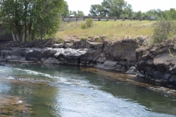
Fall River Bridge
Ashton, Idaho
6.6 miles SW of Ashton, IdahoRight off Highway 20, there's a great spot to swim, swing, and dive. There's pullouts for parking right next to the bridge. There's a rope swing under the railroad bridge and a little swimming hole to the North. As always be careful of water levels. There are rocks down the middle of the river on the North side. If they're covered, the water is high.
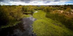
Rio Salado Habitat Restoration Area
Phoenix, Arizona
1.7 miles S of Phoenix, ArizonaHike near Phoenix, Arizona
Full Listing
Show more
Hike
Last visited on 13 Apr 2017
29.6 mi
 Full Listing
Show more
Mountain Bike
Last visited on 14 Sep 2016
Full Listing
Show more
Mountain Bike
Last visited on 14 Sep 2016
Ashton to Tetonia Trail
Ashton, Idaho
0.7 miles NE of Ashton, IdahoThe Idaho Department of Parks and Recreation undertook the project to transform the old Teton Valley Branch of the Union Pacific Railroad from Ashton to Tetonia into a trail for bikes, ATVs, and snowmobiles, runners, cross-country skiers, and horses. The trail goes from Ashton to Tetonia and can be accessed via Ashton, Marysville, Bitch Creek, Felt, or Tetonia. Information can be found at kiosks in Marysville and at Bitch Creek.
Elevation Gain (Southbound): 787 ft
Length: 29.6 mi
Twin Bridges
St. Anthony, Idaho
6.6 miles NE of St. Anthony, IdahoTwin Bridges is a beloved bridge-jumping and swimming spot on the river near St. Anthony, Idaho — a summer institution for families, teens, and college students across the upper Snake River Valley. The name comes from the setup: an old abandoned bridge stands right beside the one still in use, and the deep, slow water beneath the old span makes for about the best bridge jumping around, with no traffic to dodge and easy parking nearby.
The jumping is the main event, and it's well suited to a range of nerve. There are two distinct levels to leap from — a lower point around 11 feet and a higher one around 17 feet — so you can start small and work your way up, and the water below is plenty deep for cannonballs, flips, and gainers. Locals consider it about as good and as “reasonably safe” as bridge jumping gets, with one firm caveat: keep clear of the rocks along the sides, which can be exposed depending on the water level.
There's more to it than jumping. A little rope swing often hangs under the bridge — a favorite of the little kids — and a path up the river makes a good put-in for a short, mellow float back down. For families with young children, there's a sandbar on the north side just upstream of the action, perfect for wading and splashing away from the jumpers. The slow current is ideal for simply hanging out in the water while you watch your friends show off.
A fun local curiosity: downstream of the little rock dam on the north side lie the sunken remains of an old car, washed here after an accident years ago. When the water is low and clear you can spot its chrome bumper from the rocks and swim down for a look — a quirky bit of underwater sightseeing that regulars love.
Part of the appeal is how welcoming and community-minded the spot is. Generations of upper-valley families and Rexburg-area college students have made Twin Bridges their go-to summer swimming hole, and there's a friendly, everybody-shares-the-water vibe on a busy afternoon. It's the kind of simple, free, small-town summer pleasure that keeps people coming back week after week.
A few practical notes: it's a popular place, so expect a crowd on hot, sunny days and holidays — though it handles a lot of people well, and you rarely wait long to jump. Bring water shoes for the rocky spots, sun protection, and drinking water, always check the water depth and clear your landing before jumping (levels change through the season), keep an eye on kids near the current, and pack out all your trash. For a classic, easygoing eastern-Idaho swimming hole, Twin Bridges is hard to beat.
Big Springs
Island Park, Idaho
7.6 miles NE of Island Park, IdahoThere's also a great little walking trail along the river with placards that tell about the ecosystem and history of the area. There's about a 1/2 mile that's paved and then a 1/2 mile of dirt trail. The trail is NOT a loop. The trailhead is on the South West side of the bridge. There's a great spot to feed the fish under the West side of the bridge so bring some quarters to buy fish food. The trail to Johnny Sack's Cabin is on the North Side of the Cabin.
Campground (Fee Required)
This campground Is located on the Ashton·lsland Park Ranger District, comprising nearly 650,000 acres of National Forest System lands. Numerous amenities are offered such as single and double sites which Includes fire rings. utlllty tables. picnic tables, and reslrooms. This campground is situated nen to the beautiful Henry's Fork shaded by Lodgepole Pines. Come In and relax with friends and family. Head on out and explore the Big Springs Interpretative Trail which starts at the bridge Just Outside the campground. Be sure to visit the historical Johnny Sack Cabin, offering a unique Insight Into the history of the Big Springs Area. Just follow the asphalt walkway which will take you to the cabin Just north of the campground. Explore the historical, cultural, geological, and recreational resources this area has to offer.
Take a scenic drive south along the Mesa Falls Scenic By·Way. Stop by the Mesa Falls Visitor Center for an interpretative tour and captivating view of Upper Falls. A two mile Interpretative hiking uall will offer you a view of Canyon Rim.
Length of Stay: Forest Order
Camping or occupying a Single site for a period longer than 16 consecutive days Is prohibited. After leaving a site, a minimum of 7 days Is required before any group or person(s) from that group may reoccupy their original location.
This limit of stay restriction Is necessary to reduce displacment of other Forest desiring to occupy a particular campsite, and reducing the opportunity for visitor or group of visitors from monopolizing a campsite for long periods time (in excess of 16 days).
Fire Safety: Only You Can Prevent Forest Fires
Make sure your fire is DEAD OUT
- NEVER leave a fire unattended.
- Keep your fires small. Firewood Is available for sale. See campground host.
- Check with campground host for current fire restrictions.
- Use existing fire rings. Scrape away litter end any other burnable material within a l0 foot-diameter circle surrounding the fire ring.
- Make sure all wood fits inside the fire ring.
- To put out a campfire, slowly pour water onto the fire and stir with a shovel until all material is cool to the touch.
- Do not bury your fire. The coals can smolder and re-ignite.
- Make sure the fire is dead out. Many wildfires have been caused by abandoned campfires.
Bear Country: Required Food Storage Order
Your Safety Is Important to Us
All food and other items that might attract bears must be stored where bears cannot access them at night and during the daytime when unattended. Attended means that a person is physically present within 100 feet and in direct sight of the food.
What are bear attractants?
- All food and anything that contacted food. This includes full or empty coolers, packaging, boxes, cans, bottles, dirty dishes and silverware, etc.
- All beverages and beverage containers, full or empty (including water)
- All garbage, food scraps, and cooking grease. Never dump grease, beverages, or scraps on the ground.
- Never leave garbage in your fire pit or outside.
- Pet food and pet food bowls.
- Gas cans.
- Grills. Burn grill for at least 5 minutes after use to get rid of any residues. Clorox the grease trap.
Anything with a strong odor is an attractant for bears. Attractants must be stored in a bear-resistant manner. If you are away from your campsite or asleep at night in your test/trailer/RV, these attractants MUST BE STORED. You may be fined if you do not properly store your attractants. If you cannot properly store your attractants, inform the campground host and a bear resistant container may be provided for you.
What is bear resistant storage?
Acceptable places to store and dispose of your attractants are inside a hard-sided trailer, an enclosed vehicle, inside a bear dumpster or trash can (this campground has bear-resistant dumpster). Coolers, tents, underneath your RV/trailer the back of pick-up trucks, boxes, beverage bottles, canned goods, soft-sided trailers, and other containers are not bear resistant. All garbage must go to bear-resistant dumpsters. Garbage must never be left outside unattended. If the dumpster is full, you must take your trash back with you and inform the campground host of the situation.
NOTICE: ATV and Motorcycle use is prohibited
ATVs and motorcycles are prohibited from use in this campground. The following are exempt:
- Licensed street legal motorcycles.
- Vehicles used by handicapped individuals.
- Vehicles used by campground hosts for their official duties.
ATVs and motorcycles may be trailered into the campground, kept in the campsite on a trailer, or parked at a location designated by the campground host.
Educate Yourself
Contact the Island Park or Ashton Ranger Station for information on which areas are open to ATVs.
If you have a Dog: Keep your pet secure at all times
In the national forest, you and your dog could meet people, horses, mountain bikes, ATVs, other dogs, and wild animals. Help make the outdoor experience enjoyable for you, your dog and all the forest's users by following these safety tips:
- Please remove all feces before vacating your site.
- Give your dog plenty of water and rest, and watch for signs of stress and fatigue.
- Keep your dog leashed and under control in campgrounds. Secure your pet in a shady spot and give it lots of attention to minimize barking.
- If you encounter wild animals, respect them by restraining your dog.
Fireworks are prohibited
Fireworks or other explosives are prohibited within campgrounds and other recreation sites.
Fishing Rules: A fishing license is required to fish in this forest
- A state fishing license is required to fish in this national forest.
- A fishing license can be purchased over-the-counter at various stores in the local area. For more information, contact Idaho Fish and Game.
0.1-0.3 mi
Full Listing
Show more
Disc Golf
Last visited on 13 Apr 2015
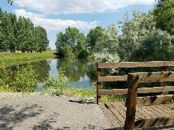
Rexburg Nature Park
Rexburg, Idaho
0.8 miles NW of Rexburg, IdahoRexburg Nature Park:
Life can be stressful, annoying, or just not good. Sometimes, it takes a moment to simply get away from the non-sense of this world; to gather yourself and seek peace and tranquility. That option is around the corner; you drive and see a trail, so you park and walk on the trail. As you walk, there's trees and sunlight shining on the leaves. You walk further and see a pond with ducks (both green and brown) and families sitting on the green grass with their kids; they watch, feed the ducks and take pictures with a smile on their face.
You go back to your vehicle and reminisce what you saw. Close to the south fork of the Teton River, is a nature park that isn't crowded with college students or infested with incoming traffic but a 15 acre park that was made so you can take your family or acquaintances for a picnic or a social gathering and enjoy; you also have the option to ride your bike or to jog on the trails.
The park is next to the Claire Boyle skate park, a beautiful golf course next to the fairgrounds and a 9 hole Frisbee golf course.
Features:
-Playground for the kids
-Fishing ponds ( A valid fishing license is required); fishing ponds for children as well.
-Wildlife and wildflowers
For more information and questions:
| Phone | 208-359-3020 Ext. 0 |
|
customerservices@rexburg.org |
Y-Mountain Summit Trail
Provo, Utah
2.8 miles E of Provo, UtahY Mountain is located directly east of Brigham Young University (BYU) in Provo, Utah, United States. The Slide Canyon/Y Mountain Trail leads to a large block Y located 1.2 miles (1.9 km) from a parking area at the mountain's base. This hillside letter was built over a hundred years ago as the insignia for BYU. For years the trail to the Y has been one of the most hiked trails in Utah Valley and provides a beautiful view of Provo and Orem, the rest of the many cities in Utah Valley and Utah Lake. The trail is also regularly used by hikers, bikers, paragliders and hunters to access the backcountry in the Slide Canyon area.
The large white Y on the side of the mountain has become the nationally recognized insignia for BYU and the reason why BYU is often called "the Y". It is made of concrete and is 380 feet high and 130 feet wide (116 by 40 m). The Y is even larger than the "Hollywood Sign" in Los Angeles.
There are 14 strands of lights placed around the perimeter of the Y, which are lit five times a year by the Intercollegiate Knights. It is lit for Freshman Orientation, Homecoming, Y Days, and graduation in April and August.
0.8 mi
 Full Listing
Show more
Hike
Last visited on 13 Apr 2015
Full Listing
Show more
Hike
Last visited on 13 Apr 2015
Conant Creek Pegram Truss Railroad Bridge
Ashton, Idaho
5.0 miles SE of Ashton, IdahoAs part of the Rails to Trails project, this old railroad bridge has been transformed into a very safe little viewing experience for the whole family. You can drive right up to the bridge where there is a great little spot to park. Conant Creek meeanders hundreds of feet below the bridge. It's about 300 yards across and whether you're taking in the vibrant colors of spring, the beautiful fall colors, or the Tetons looming in the background, the view is spectacular.
The bridge is part of the 30 mile Ashton-Tetonia Trail. There is a smaller bridge less than 2.5 miles north on the trail.
Donut Falls
Salt Lake City, Utah
14.9 miles SE of Salt Lake City, UtahDonut Falls is one of the most popular family hikes in the Salt Lake City area — a short, scenic walk in Big Cottonwood Canyon to a genuinely unusual waterfall. The “donut” name comes from the falls itself: Mill D South Fork Creek pours through a hole it has worn in the roof of a rock grotto, so the water appears to vanish into a doughnut-shaped opening in the cave ceiling before dropping into the chamber below. It's a favorite first hike for newcomers to the outdoors and an easy, rewarding escape for locals trading city bustle for pine forest and rushing water.
From the trailhead, a well-marked path winds through cool evergreen forest and open meadow, following the creek up toward the falls. The last stretch involves a bit of a rock scramble up slick, stream-polished stone to reach the mouth of the grotto and get the classic view up into the donut — go slowly here, as the wet rock is genuinely slippery and causes plenty of scrapes and turned ankles. Climbing on top of the cave for a photo down through the hole is especially dangerous: the mossy lip is treacherously slick, and falls from the top have caused several deaths over the years. The classic — and far safer — view is from below, looking up into the donut.
The total distance depends on the season and how far up you can drive. From about July 1 through October 31, you can usually drive the extra 0.8-mile dirt road past the large lot to the upper trailhead, shrinking the hike to as little as 1.4–1.5 miles round trip; the rest of the year (and whenever the upper road or the highway gate is closed by snow) it stretches to roughly 3 to 3.5 miles. Either way it's a gentle grade suitable for kids, and in winter it becomes a lovely, easy snowshoe. In early spring, count on lingering snow and ice — especially on the final rock scramble to the falls, which turns slick and tricky — and note that the restrooms and upper parking often aren't open yet.
One crucial thing to know: Big Cottonwood Canyon is a protected drinking-water watershed for the Salt Lake Valley, and its watershed rules are strict and firmly enforced: under them, dogs are not allowed anywhere in the canyon and swimming or wading is prohibited, even on a hot day, so plan to leave the pup at home. These rules keep the water clean for the hundreds of thousands of people who drink it downstream.
Because it's so beloved and so close to the city, the small dirt parking area fills fast; in summer, come at first light or on a weekday to find a spot and beat the crowds. Bring water, wear shoes with real traction for the wet final scramble, and pack a camera for the falls and the forest. Check current road and gate status in Big Cottonwood Canyon before heading up, especially outside of summer, and enjoy one of the Wasatch's classic little adventures.
×


