


Refine Search
- hike 10
- camp 5
- swim 4
- kayak 2
- backpack 2
- cave 1
- hot springs 1
- whitewater 1
- snowshoe 1
- mountain bike 1
- canoe 1
12 locations
Add Location
 Full Listing
Show more
Camp, Cave, Hike, Kayak, Swim
Full Listing
Show more
Camp, Cave, Hike, Kayak, Swim
 Full Listing
Show more
Backpack, Camp, Hike, Kayak, Swim
Full Listing
Show more
Backpack, Camp, Hike, Kayak, Swim
 Full Listing
Show more
Hike, Swim
Full Listing
Show more
Hike, Swim
 Full Listing
Show more
Camp, Hot Springs
Full Listing
Show more
Camp, Hot Springs
 Full Listing
Show more
Camp, Swim, Whitewater
Full Listing
Show more
Camp, Swim, Whitewater
0.9 mi
 Full Listing
Show more
Hike
Full Listing
Show more
Hike
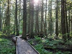
Trail of the Cedars
Apgar Village, Glacier National Park
13.2 miles NE of Apgar Village, Glacier National ParkThe Trail of the Cedars is one of the most popular hikes in the park because of it offers great views without too much exertion. It is a short loop hike around Avalanche Creek in Glacier National Park. The hike is a fairly easy walk through a cedar tree forest and offers gorgeous views of Avalanche Creek which now cascades downstream as glacially melted water. The trees in this forest are some of the tallest and the oldest in the park, reaching up to 100 feet tall and 4 to 7 feet across at around 500 years old. This area has survived fires and avalanches for years, allowing it to flourish. The trail is wheelchair accessible and leads to a footbridge at the creek.
Just past the Avalanche Lake trail junction is an even closer view of the creek and the trailhead to Avalanche Lake, which is another 1.6 miles for those feeling a little more adventurous.
After passing Avalanche Creek, the trail reaches past the Avalanche Creek Campground and loops back out to the road. Parking can get difficult here because it is such a popular hike and there are limited spaces. The trailhead is about 5 and a half miles from Lake McDonald Lodge, along Going to the Sun Road.
4.0 mi
 Full Listing
Show more
Camp, Canoe, Hike
Full Listing
Show more
Camp, Canoe, Hike
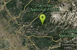
Saddlebag Lake
Lee Vining, California
8.3 miles W of Lee Vining, CaliforniaA man-made lake found in the Inyo forest, resting at about 10,008 feet above sea level, Saddlebag Lake is located just outside the Tioga Pass entrance to Yosemite National Park. This lake has some of the best fishing and hiking in the Eastern Sierra. Saddlebag has a water taxi that takes visitors to the opposite end of the lake where there are incredible alpine views and access to the Twenty Lakes Basin, where many people enjoy trout fishing.
There is a 4 mile loop hike that takes you around the perimeter of the lake. There are several areas to stop and fish, as well as views of North Peak, Mount Conness, Excelsior Mountain, and Saddlebag Crest. If you choose to continue the hike to the Twenty Lakes Basin, that distances roughly doubles in size. However, it is not a particularly difficult hike, and it can be completed in a day.
Many visitors choose to camp at one of the campsites outside the lake. Smaller parties choose the campground by the dam, but the Trailhead Group Campsite hosts around 25 people. And for those who would prefer a bed and an alternative to pit toilets, Saddlebag Lake Resort has cabins, a cafe, and more.
1.1-4.7 mi
 Full Listing
Show more
Backpack, Hike, Mountain Bike, Snowshoe
Full Listing
Show more
Backpack, Hike, Mountain Bike, Snowshoe
Bells Canyon
Sandy, Utah
1.9 miles E of Sandy, UtahBells Canyon is a moderate, 4.5 mile hike that begins in a residential area and ends at a waterfall in the enter of the canyon's forest. The first 1/2 mile of the hike is relatively easy and leads straight to the reservoir, which is one of the best views of the hike. There are several places for people to stop and have a snack surrounding the reservoir, although some choose to turn around before the trail gets too difficult.
Once you reach the sign that directs you to the waterfall, the hike gets considerably more difficult. It's about 1.2 miles of climbing over large rocks at a serious incline, but the views are incredible. Bells Canyon has gorgeous fall foliage in the autumn months, and once spring comes around, everything is beautiful and green. There is a creek that flows along the trail, several open areas of meadow and wildflowers, and spectacular views of the canyon and the Salt Lake Valley. It's a hike that pays off as you climb it.
The waterfall is in the center of a grove of trees. There is a steep hill downward that will take you to the base of the fall, but it can be treacherous to reach, so tread carefully.
Bells Canyon does not see much Mountain Bike traffic, and for good reason! It starts out very steep and with a loose gravel trail base, it makes for a tough climb on a bike. There are steps that are all but impossible to ride up (or down). After reaching the very scenic Lower Bells Canyon Reservoir the trail is much better! It turns to a fun single track through the trees. After crossing the stream above the Reservoir the trail becomes snarled with large granite boulders and is tough for even a hiker to negotiate. Courtesy of Singletracks.com
1.1 mi
 Full Listing
Show more
Hike
Full Listing
Show more
Hike
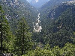
Lundy Canyon
Bridgeport, California
16.2 miles S of Bridgeport, CaliforniaIn just one 3 mile hike, Lundy Canyon provides views of waterfalls, meadows, mountains, and if you're up for it, a trip to the Twenty Lakes Basin.
There is much to take in even after going just .5 miles. The trail first takes you through a grove of trees and past a beaver pond until you reach the lower Lundy Canyon Falls. These twin waterfalls stand at 70 feet high and are easily seen from the trail, although it is isn't an up close and personal look. Once you pass the waterfalls, you enter the Hoover Wilderness.
The trail gets a little less straightforward after this point. Head west for a 2,000 ft climb up to Burro Lake, which sits at an altitude of 10,551 feet, or head east for something slightly more tame. This trail will take you through some of Lundy Canyon's famous wildflower meadows and straight to the base of the second set of falls in the canyon. Mill Creek drops off in four separate cascades that total about 100 feet. Starting from the base of the falls and climbing upward, the trail begins to get more difficult. A series of switchbacks takes you past one more waterfall, out of the canyon and to the Twenty Lakes Basin.
Fall Creek Falls
Swan Valley, Idaho
2.1 miles SW of Swan Valley, IdahoFall Creek Falls is one of eastern Idaho's most beloved and photographed waterfalls — a broad, 60-to-70-foot curtain of water that spills over mossy travertine ledges directly into the Snake River near Swan Valley. It's a genuinely unusual sight: most waterfalls tumble into a creek or pool, but this one pours straight into a major river, framed by the cottonwoods and canyon walls of the beautiful Swan Valley. It's especially glorious in autumn, when the riverside trees blaze gold and the whole scene lights up.
The best part for most visitors is how easy it is to reach. From Highway 26 just west of Swan Valley, turn onto gravel Fall Creek Road (Forest Road 058) and follow it along the Snake River to a small pull-out near the falls. From there it's more of a short walk than a hike — cross a small stream and stroll a couple of minutes to a flat perch right at the top of the falls, with sweeping views over the waterfall and the river beyond.
Adventurous visitors can scramble down for a closer look. A steep, sandy slide and a set of natural rock steps lead down toward the base, where you'll find a mossy grotto tucked behind and beneath the falls — a magical little chamber where you can stand in the cool mist and shade with the water curtaining down in front of you. The ceiling is low, so watch your head, and the rock steps kick up far less dust than the loose slide.
Be careful near the edges. The viewpoints at the top sit right above the falls, with abrupt, unrailed cliff drops of 10 to 15 feet in places, so keep well back from the lip and hold onto children — the rock can be slick near the water. The short scramble to the bottom is steep and can be slippery too.
The falls are a favorite of paddlers, too: because the water spills right into the Snake, kayakers and rafters floating this stretch below Palisades Dam can pull up close to the base for a view you can't get any other way. In winter the falls partially freeze into curtains and columns of ice, drawing photographers to the snowy canyon. However you come at it — on foot from the road above or by boat from the river below — it's a quick, high-reward stop between Idaho Falls and the Wyoming line.
The falls run year-round and reward a stop in any season, though flows are fullest with spring snowmelt and the color is best in fall. For photographers, midday sun is harsh out here; early morning or evening light is far kinder. Keep an eye on the river, too — boaters and rafters drift past below, and the area teems with wildlife, including the American white pelicans that cruise this stretch of the Snake. A Forest Service campground and public boat ramps sit nearby, making it easy to turn a quick stop into a longer stay. Bring water and sturdy shoes, and enjoy one of those “how have I never seen this before?” Idaho gems.
4.6 mi
 Full Listing
Show more
Hike
Full Listing
Show more
Hike
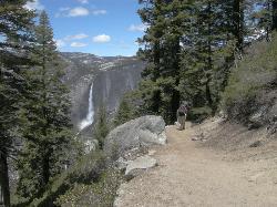
Four Mile Trail
Yosemite National Park
9.5 miles S of Yosemite National ParkFour Mile Trail is a moderate hike that offers the best views of some of Yosemite's most famous landmarks, including Yosemite Falls, Half Dome, Clouds Rest, North Dome, El Capitan, and the Royal Arches. The hike connects Yosemite Valley and Glacier Point, making it one of the best ways to see the highlights of the park in just four miles.
There are several switchbacks, making it a little bit more difficult going up than it is going down. While the name of the hike is Four Mile Trail, it's actually 4.7 miles one way and 9.4 miles round trip and takes about 2-5 hours to complete. Just around a mile or so into the hike, you'll be able to see Yosemite Falls completely. This is the only place in the world where the view of this waterfall, the highest in North America, is not obstructed by rocks or trees. Because Yosemite Falls is such a big part of the Four Mile Trail, the best time to visit is in the spring, just after the snow melts, because that's when it's at its biggest.
At the top of the hike, there is a gift shop and cafeteria, allowing visitors some time to stay, rest, grab a bite, and enjoy the scenery.
15.9 mi
 Full Listing
Show more
Hike
Full Listing
Show more
Hike
Valley Loop Trail
Yosemite Valley, Yosemite National Park
1.0 miles SW of Yosemite Valley, Yosemite National ParkThe Valley Loop trail at the heart of Yosemite is one of the best ways to discover the park. The entire loop is 11.5 miles long, and there are several places to enter and exit the trail throughout. However, because the trail avoids most main roads, it is best to take a map along with you.
Starting at Lower Yosemite Falls, the main trail takes hikers along the Merced River to various wildflower meadows and to some of Yosemite's most impressive landforms. The beginning of the hike guides visitors through the Three Brothers rock formation and eventually to El Capitan in Yosemite Valley. From there, those planning on doing the 7.2 mile half loop will cross the Merced River and start heading back to Yosemite Village. Those continuing on will head past El Capitan toward Bridalveil Falls and eventually loop back to the village.
There is almost no elevation gain on this hike, so it is essentially, a walk in the park. However, it is pretty long, even for those opting for the half loop, so make sure you've set aside enough time to complete whichever section of the hike you're planning on doing. The full loop usually takes about 5-7 hours, and the half loop usually takes 2.5-3.5 hours.
1.9 mi
 Full Listing
Show more
Hike
Full Listing
Show more
Hike
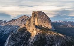
Half Dome
Yosemite Valley, Yosemite National Park
4.4 miles E of Yosemite Valley, Yosemite National ParkHalf Dome is the most popular and difficult hike in Yosemite Valley. The trail is about 14 miles long with an elevation gain of 4800 feet. There are cables to help you scale up to the summit once you get within 400 feet of it. It takes about 10-12 hours to complete and is essentially straight up the entire way.
Because it is such a dangerous hike, there are many precautions you should take before attempting Half Dome. Leave around sunrise and have a set time to turn back, even if you don't reach the summit. Make sure everyone in your group has a flashlight in case it gets dark before you return. It is also recommended to bring gloves to help improve your grip on the cables and to keep your hands from burning when touching the cables.
In order to reduce the amount of people on the trail creating a bottleneck at the cables, the park has implemented a permit system. You must have a permit to access the cables.
While the hike to get there is dangerous and difficult, the view along the way and especially from the summit is unmatched, offering sites of Vernal and Nevada Falls, Liberty Cap, the High Sierras, and panoramic views of the entire valley.
Standish Hickey Area
Lakeshore, California
10.0 miles NE of Lakeshore, CaliforniaStandish-Hickey is an inland river canyon that runs along Highway 101 just 180 miles from San Fransisco. It's home to a two-mile stretch of the south fork on Eel River, where many visitors enjoy swimming, kayaking, or fishing. It's also the entrance to the Redwood Belt and is home to the 1200 year old Captain Miles Standish Tree, the tallest redwood that towers over visitors at 225 feet.
The park offers a variety of activities, such as boating, hiking, tent, hike, or RV camping, fishing, swimming, picnicking, as well as a place to rest and get some fresh air, especially for those on road trips. It's definitely a place you'll want to visit in the summertime. The high water in the winter causes the seasonal bridges to be removed and much of the park becomes inaccessible.
There are three different hikes offered here. For those looking for a brisk walk, there is a 1.7 mile loop and a 2 mile loop, and for those looking for something a little more strenuous, there is a challenging 6 mile loop as well.
Be sure to watch out for poison oak and to be careful around the river, as the water can get high in the winter. The campsites can accommodate a maximum of eight people unless it's a group campsite. Leashed pets are allowed on the campsite but not on the hiking trails.
Gods Bath
Phoenix Lake-Cedar Ridge, CA, California
14.4 miles E of Phoenix Lake-Cedar Ridge, CA, CaliforniaGod's Bath swimming hole in the Clavey River is a beautiful and popular location to take a dive in. However, the hike to get there is about one mile of rock climbing. The trailhead begins on a bridge, where there are ropes to help you along the steep trail down into the canyon. The rest of the hike is a little less than a mile, but it does require you to wade in the stream as you hop and climb over the rocks. The water at God's Bath is crystal clear, but it tends to get cold, so be sure to visit in the summer. There are also smaller pools on the way down to God's Bath which visitors can use to take a quick break on their treacherous journey to the official pool. There are also a handful of popular cliff jumping spots surrounding the pool.
Because it is so well known, it tends to get a little crowded, so visitors are encouraged to take out any trash or belongings they may have brought in with them.
The hike can be dangerous if you're not careful, so watch out for slippery or mossy rocks, as well as poison oak, which has been known to gather near the bridge.
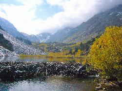
Wild Willy's Hot Spring
Mammoth Lakes, California
11.0 miles E of Mammoth Lakes, CaliforniaWild Willy's Hot Springs, also known as Crowley Hot Springs, is a spring located in Long Valley. Long Valley is home to one of the highest concentrations of geothermal surface water in California. Wild Willy's is surrounded by mountains in sagebrush plains, so you get to see a pretty view while you soak and relax in the natural hot springs.
There is a long wooden walkway that's about .2 miles long from where you park that leads you straight to the springs. The surrounding area is wide open with views of the Sierra Nevadas, making it quiet and peaceful if the springs aren't crowded, which they usually are.
There are a few pools here, the larger one attracting more people since it is deeper and has the capacity to accommodate larger groups. The smaller ones are a bit more shallow and are best for a couple people. The smaller pools are also usually hotter, making it feel more like a hot tub. The downside to these hot springs is that it attracts so many visitors because it is free and public.
The water temperature ranges from 95 - 105 degrees, depending on the day.
There are designated camping areas for those who prefer the overnight experience.
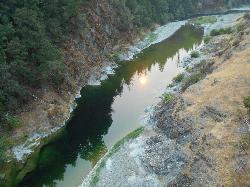
Merced River
Yosemite Valley, Yosemite National Park
0.6 miles SE of Yosemite Valley, Yosemite National ParkThe main fork of Merced River at Yosemite National Park is a perfect place to fish, swim, raft, and even pan for gold.
The river circles around the center of Yosemite Valley, and almost every point on the river has views of the most breathtaking parts of the park, from Yosemite Falls to Glacier Point.
Merced River is one of the few places in Yosemite that offer whitewater river rafting. The rapids go from Redbud to Briceburg and range from levels 2 to 4. It's a class IV run at peak snow melt, but it does get lower and slower as the season goes on. There are also several pullouts along the river canyon where people can get their own flotation devices and float the river themselves, although it's not recommended until late June, when the river has slowed down a bit.
It's also around this time that many people choose to go swimming in the river. The main fork is the ideal place for this. There are several places to camp along the river, such as Dirt Flat, Dry Gulch, McCabe Flat, Willow Placer, Railroad Flat, and more.
Fishing is also a favorite activity of those who come to the Merced River, but there are a few more conditions on fishing than usual. Catch and release is strongly encouraged, and only fish larger than 12 inches can be taken from the river.
×


