


Saddlebag Lake
Lee Vining, California

| Address: | Saddlebag Lake Resort, Saddlebag Lake Rd, Lee Vining, CA 93541, USA |
| GPS: |
37°57'58.2"N 119°16'17.4"W Maps | Directions |
| State: | California |
| Trail Length: | 4.00 miles |
| Trail Type: | Loop |
| Hike Difficulty: | Beginner |
| Elevation Gain: | 311 feet |
| Trails/Routes: | 4.0 mi |
Lakes Trails Pet Friendly Fishing
Camp, Canoe, and Hike
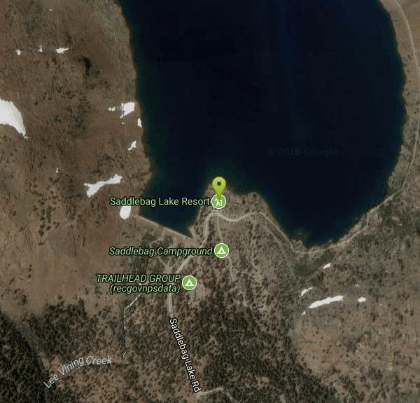
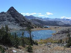
A man-made lake found in the Inyo forest, resting at about 10,008 feet above sea level, Saddlebag Lake is located just outside the Tioga Pass entrance to Yosemite National Park. This lake has some of the best fishing and hiking in the Eastern Sierra. Saddlebag has a water taxi that takes visitors to the opposite end of the lake where there are incredible alpine views and access to the Twenty Lakes Basin, where many people enjoy trout fishing.
There is a 4 mile loop hike that takes you around the perimeter of the lake. There are several areas to stop and fish, as well as views of North Peak, Mount Conness, Excelsior Mountain, and Saddlebag Crest. If you choose to continue the hike to the Twenty Lakes Basin, that distances roughly doubles in size. However, it is not a particularly difficult hike, and it can be completed in a day.
Many visitors choose to camp at one of the campsites outside the lake. Smaller parties choose the campground by the dam, but the Trailhead Group Campsite hosts around 25 people. And for those who would prefer a bed and an alternative to pit toilets, Saddlebag Lake Resort has cabins, a cafe, and more.
More Information
Be courteous, informed, and prepared. Read trailhead guidelines, stay on the trail, and don't feed the wildlife.
Read More- Plan Ahead and Prepare
- Travel & camp on durable surfaces
- Dispose of waste properly
- Leave what you find
- Minimize campfire impacts
- Respect wildlife
- Be considerate of other visitors
Directions
From Lee Vining, California
- Head southeast on US-395 S toward 2nd St (0.7 mi)
- Turn right onto CA-120 WParts of this road may be closed at certain times or days(9.9 mi)
- Turn right onto Saddlebag Lake RdDestination will be on the left(2.5 mi)


Trails
Distance ?
4.0 milesElevation Gain ?
-4 feetReal Ascent ?
477 feetReal Descent ?
481 feetAvg Grade (0°)
0%Grade (-18° to 9°)
-32% to 16%Elevation differences are scaled for emphasis. While the numbers are accurate, the cut-away shown here is not to scale.
Other Hiking Trails and Canoeing Areas Nearby
Gaylor Lakes
Yosemite Valley, CA
3.7 miles SGaylor Lakes is one of Yosemite's most underrated hikes. It's a 2 mile trail with views the entire way. At various points along the trail, you can see Dana Meadows and the mountains...
Hike, Swim 1.1 mi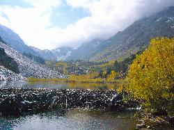
Lundy Canyon
Bridgeport, California
3.9 miles NIn just one 3 mile hike, Lundy Canyon provides views of waterfalls, meadows, mountains, and if you're up for it, a trip to the Twenty Lakes Basin. There is much to take in even after going...
Hike 4.0 mi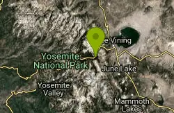
Mono Pass
Yosemite Valley, CA
5.2 miles SAt an elevation of 10,600 feet, the hike through Mono Pass is an 8 mile journey that takes you across the High Sierras, through several meadows, and stops at a few different lakes along the...
Hike, Swim 0.8-4.1 mi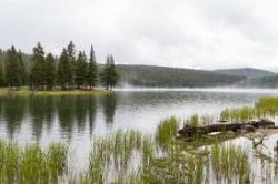
Dog Lake and Lembert Dome
Yosemite Valley, CA
6.4 miles SWThe hike to Dog Lake is often paired with the hike to Lembert Dome, because the two are so close in proximity. Each hike by itself is 2.8 miles round trip, but Lembert Dome has an elevation gain of...
Hike, Swim 3.6 mi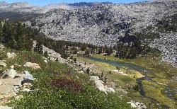
Lyell Canyon
Wawona, California
7.2 miles SLyell Canyon is a breezy, 8 mile hike through the Tuloumne Meadows of Yosemite. While it is a little bit of a longer hike, the total elevation gain is about 200 feet, making it pretty flat and...
Hike
Tuolumne Meadows
Tuolumne County, California
7.4 miles SWA beautiful alpine meadow found in the upper Sierra Nevada Mountains. Open during the summer, this meadow offers excellent views of nearby granite domes and mountains. There is a roadway through...
Camp, Hike
Glen Aulin
Glen Aulin, California
9.0 miles SWThis trail is a popular route to take in the Yosemite High Country because it is a good introductory hike into the backcountry. At the end of the hike there are several waterfalls as well as a...
Backpack, Camp, Hike, Swim 6.0 mi
Glen Aulin
Wawona, California
9.0 miles SWThis is an 11 mile hike along the Tuolumne River to Glen Aulin. There is a view to take in at every turn on this hike, whether it's the Tuolumne River, Tuolumne Fall, Soda Springs,...
Backpack, Camp, Hike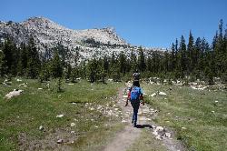
Elizabeth Lake
Wawona, California
10.0 miles SWElizabeth Lake is a gorgeous lake tucked underneath the High Sierras in Yosemite. It's about a 4.8 mile hike to reach it, with an elevation gain of 1000 feet. Even though it's not super long,...
Hike, Swim 0.9-3.2 mi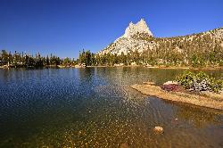
Cathedral Lakes
Wawona, California
11.8 miles SWOne of the busiest trails in the Tuloumne Meadows area, the hike to Cathedral Lakes is a gorgeous 7 mile walk to the perfect place to rest and recuperate. While there are several High Sierra...
Hike, Swim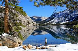
Tenaya Lake
Yosemite Valley, Yosemite National Park
14.0 miles SWTenaya Lake is one of the most visited destinations in Yosemite National Park. The lake is easily accessed by Highway 120/Tioga Pass road which runs along the north shore of the lake. On the east...
Canoe, Hike, Kayak, Swim 5.7 mi
Ten Lakes
Tuolumne Meadows, Yosemite National Park
14.3 miles WA 6.4 mile hike will lead you to three of the Ten Lakes at Ten Lakes Basin. There are three possible trails to take to see this phenomenon. The shortest begins at Yosemite Creek. The other two...
Backpack, Camp, Hike 1.2-1.6 mi
May Lake
Yosemite Valley, Yosemite National Park
14.6 miles SWMay lake is a relatively small lake that rests at the base of Mt. Hoffman in Yosemite National Park. One of the park's most scenic lakes, May lake not only gets up close and personal with...
Hike, Swim 2.1 mi
Snow Creek Falls
Yosemite Valley, Yosemite National Park
20.0 miles SWSnow Creek is one of the more difficult waterfalls to find in the valley, but in the spring and summer months, the elusive waterfall can be seen from the Mirror Lake Trail, a 5 mile loop around...
Backpack, Hike 1.9 mi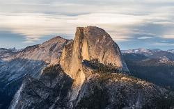
Half Dome
Yosemite Valley, Yosemite National Park
20.2 miles SWHalf Dome is the most popular and difficult hike in Yosemite Valley. The trail is about 14 miles long with an elevation gain of 4800 feet. There are cables to help you scale up to the summit once you...
Hike 0.7 mi
Lukens Lake
Tuolumne Meadows, Yosemite National Park
20.4 miles SWLukens Lake is a small lake in the White Wolf area of Yosemite National Park. The hike is a short, 1.6 mile walk through a forest to the secluded lake surrounded by trees and a small...
Hike, Swim 4.0 mi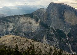
North Dome
Yosemite Valley, Yosemite National Park
21.4 miles SWNorth Dome is a strenuous 10.4 mile hike that gives visitors a close up view straight at Half Dome from across the valley. It also has a unique view of Clouds Rest peak. Because the hike...
Backpack, Hike
Mirror Lake
Yosemite Valley, Yosemite National Park
21.4 miles SWMirror Lake is a seasonal lake situated in a secluded corner of the beautiful Yosemite Valley. The lake sits at the base of Half Dome and allows a different perspective of the famous monolith....
Backpack, Hike, Swim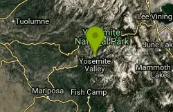
Harden Lake
Big Oak Flat, Yosemite National Park
21.6 miles WThe hike to Harden Lake at Yosemite is essentially a long walk. Much of the trail is walking down Tioga Road, an old gravel street that has been part of Yosemite since its foundation. The trail is...
Backpack, Hike 2.9 mi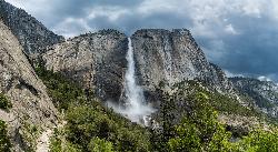
Upper Yosemite Falls
Yosemite Valley, Yosemite National Park
22.4 miles SWYosemite Falls is the tallest waterfall in North America, standing at 2,425 feet. It's made up of Upper Yosemite Falls, Lower Yosemite Falls, and the middle cascades. Lower Yosemite Falls...
HikeNearby Campsites
Tuolumne Meadows
Tuolumne County, California
7.4 miles SWA beautiful alpine meadow found in the upper Sierra Nevada Mountains. Open during the summer, this meadow offers excellent views of nearby granite domes and mountains. There is a roadway through...
Camp, Hike
Glen Aulin
Glen Aulin, California
9.0 miles SWThis trail is a popular route to take in the Yosemite High Country because it is a good introductory hike into the backcountry. At the end of the hike there are several waterfalls as well as a...
Backpack, Camp, Hike, Swim 6.0 mi
Glen Aulin
Wawona, California
9.0 miles SWThis is an 11 mile hike along the Tuolumne River to Glen Aulin. There is a view to take in at every turn on this hike, whether it's the Tuolumne River, Tuolumne Fall, Soda Springs,...
Backpack, Camp, Hike 5.7 mi
Ten Lakes
Tuolumne Meadows, Yosemite National Park
14.3 miles WA 6.4 mile hike will lead you to three of the Ten Lakes at Ten Lakes Basin. There are three possible trails to take to see this phenomenon. The shortest begins at Yosemite Creek. The other two...
Backpack, Camp, Hike
Merced River
Yosemite Valley, Yosemite National Park
23.0 miles SWThe main fork of Merced River at Yosemite National Park is a perfect place to fish, swim, raft, and even pan for gold. The river circles around the center of Yosemite Valley, and almost every...
Camp, Swim, Whitewater
Crystal Lake
Mammoth Lakes, California
28.8 miles SEUnlike many hikes in the Sierra's, Crystal lake can be done as a day hike and as the perfect way to get away for a bit. As hikers make their way to the lake, they will see the monolith Crystal...
Camp, Hike
Crane Flat
Big Oak Flat, Yosemite National Park
32.6 miles SWCrane Flat Campground is a meadow and forest between Tuolumne and Merced Groves of Giant Sequoias. The campground is 30 minutes outside Yosemite Valley, has restrooms and picnic...
Backpack, Camp, Hike, Snowshoe
Wild Willy's Hot Spring
Mammoth Lakes, California
34.6 miles SEWild Willy's Hot Springs, also known as Crowley Hot Springs, is a spring located in Long Valley. Long Valley is home to one of the highest concentrations of geothermal surface water in...
Camp, Hot Springs
Crowley Lake Campground
Crowley Lake, California
38.7 miles SENestled amidst the stunning Eastern Sierra region, Crowley Lake BLM Campground near Benton, California, is a hidden gem waiting to be discovered by nature enthusiasts and camping aficionados. With...
Camp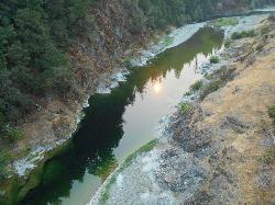
Standish Hickey Area
Lakeshore, California
46.4 miles SStandish-Hickey is an inland river canyon that runs along Highway 101 just 180 miles from San Fransisco. It's home to a two-mile stretch of the south fork on Eel River, where many...
Backpack, Camp, Hike, Kayak, Swim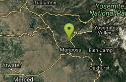
Briceburg Recreation Area
Midpines, California
46.6 miles SWCamp, Kayak, and Swim near Midpines, California
Camp, Kayak, Swim


