


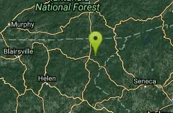
War Woman Dell Wildlife Management Area
Clayton, Georgia
Camp, Hike, and Horseback
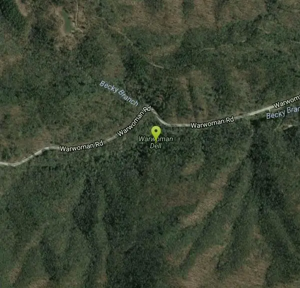
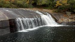
Warwoman Dell Nature Trail and Becky Branch Falls Trail is a 0.8 mile out and back trail located near Clayton, Georgia that features a waterfall and is good for all skill levels. The trail is primarily used for hiking and is accessible year-round.
More Information
Add ResourceBe courteous, informed, and prepared. Read trailhead guidelines, stay on the trail, and don't feed the wildlife.
Read More- Plan Ahead and Prepare
- Travel & camp on durable surfaces
- Dispose of waste properly
- Leave what you find
- Minimize campfire impacts
- Respect wildlife
- Be considerate of other visitors
Directions
From Clayton, Georgia
- Head north on S Main St toward E Savannah St (72 ft)
- Turn right at the 1st cross street onto E Savannah St (0.2 mi)
- Continue straight onto Rickman Dr (0.5 mi)
- Turn right onto Warwoman RdDestination will be on the right(2.2 mi)
Located near Clayton, Georgia
Other Hiking Trails and Horseback Trails Nearby
Turtleback Falls
Lake Toxaway, North Carolina
26.2 miles NETurtleback Falls was named for its domed shape, similar to the back of a turtle. It's also called "umbrella falls" for the same reason. Visitors slide down Turtleback as the...
Backpack, Hike, Swim 1.0 mi
Hidden Falls
Lake Toxaway, North Carolina
26.2 miles NEHidden Falls is a serene family-friendly swimming hole in Pisgah National Forest just down river from the towering Rainbow Falls. It's on the Horsepasture River "hidden" just a few...
Hike, Swim 1.3 mi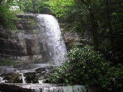
Rainbow Falls
Lake Toxaway, North Carolina
26.4 miles NERainbow Falls is one of the most spectacular waterfall settings in the Blue Ridge Mountains of North Carolina. This 150-ft. tall waterfall is impressive, especially after rainy weather that swells...
Hike, Swim
Mt. LeConte Lodge
Sylva, North Carolina
35.6 miles NHigh atop Mt. LeConte in the Great Smoky Mountains National Park, LeConte Lodge® is the highest guest lodge in the eastern United States. It is situated on an open glade just below the summit of...
Camp, Hike, Horseback, Rock Climb
Courthouse Falls
37.3 miles NE
Courthouse Falls is a beautiful 45 foot waterfall that is popular to visit. This waterfall is an easy 3/4 mile hike from the parking lot on Courthouse Creek Road (FSR 140) or can be accessed from the...
Hike, Swim 1.7 mi
Flat Laurel Creek
39.6 miles NE
Flat Laurel Creek is a 3.18 mile multi-use trail that is perfect for exploring on foot, horse and bike. This trail can be accessed from a parking lot on either end, making it easy to begin...
Hike, Horseback, Mountain Bike, Swim 7.1 mi
Daniel Ridge Loop
Canton, North Carolina
40.5 miles NEThis is a classic, short Pisgah loop. It's moderately technical most of the way with a couple of trickier sections. Most people prefer to approach it counter-clockwise, but it can be ridden...
Hike, Mountain Bike 3.1-4.3 mi
Farlow Gap
Canton, North Carolina
40.5 miles NEThis is one of the most technical downhills in Pisgah: very steep and rocky! The trail drops about 2000 ft in 3 miles then connects with the Daniel Ridge trail. The climb to the gap is long (9 miles)...
Hike, Mountain Bike 0.2-2.8 mi
Graveyard Fields
Brevard, North Carolina
41.5 miles NEGraveyard Fields is a beautiful hike known for it's forests, wild flowers and two beautiful waterfalls. The Blue Ridge Mountains surround this area creating stunning views throughout the...
Hike, Swim 0.8 mi
Daniel Ridge Falls
Brevard, North Carolina
42.0 miles NEThis waterfall in Pisgah National Forest near Brevard has multiple names: Tom's Spring Branch Falls, Daniel Ridge Falls and Jackson Falls. It’s an easy half-mile hike on the Daniel Ridge...
Hike, Mountain Bike, Swim
Butter Gap / Trail #123
Brevard, North Carolina
42.1 miles NEThe right (western) fork, which is open to mountain bikes, leads to FS 471D, which some riders use as part of a large loop; otherwise, they must backtrack down Butter Gap Trail. *The portion of the...
Hike, Mountain Bike
Skinny Dip Falls
Brevard, North Carolina
42.2 miles NESkinny Dip Falls is a beautiful and family friendly waterfall. Despite the misleading name, bathing suits are not optional at Skinny Dip Falls. Skinny Dip Falls is a long, thin cascading waterfall...
Hike, Swim
Coontree Recreation Area
Brevard, North Carolina
43.4 miles NECoontree Recreation Area is a beautiful area with many amenities and activities on the Davidson River. This recreation area is best known for its picnic area with a beautiful view of the river. The...
Hike, Mountain Bike, Swim
Looking Glass Falls
Brevard, North Carolina
43.5 miles NELooking Glass Falls is a gorgeous and easily accessible waterfall in Brevard, North Carolina. This waterfall is a short and beautiful walk from Pigsah Highway (Highway 276). Parking is available just...
Hike, Swim
Avery Creek / 327
Brevard, North Carolina
44.8 miles NEThe bottom end of Avery Creek can be accessed via FS 477, and the top can be accessed via the Buckwheat Knob trail, the Black Mountain trail, or the Club Gap trail. Avery Creek descends for 3.2 miles...
Hike, Mountain Bike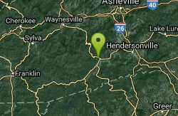
Thrift Cove
Brevard, North Carolina
44.8 miles NEStart riding the trail at the back of the parking lot. Go about 0.1 miles and turn right up Thrift Cove trail. Follow the red blazes and turn left at the intersection with Grass Road. On the way back...
Hike, Mountain Bike
Big East Fork
Canton, North Carolina
44.9 miles NEBig East Fork is a trail along Pigeon River with a variety of activities available. This trail travels through heavy forest along the river with beautiful, clear water. There are several waterfalls...
Backpack, Hike, Kayak, Swim
Davidson River Campground
Pisgah Forest, North Carolina
44.9 miles NEDavidson River Recreation Area offers camping and outdoor activities for the whole family. The campground boasts several loops of shaded campsites, as well as access to hiking trails, fishing spots,...
Camp, Hike, Swim
North Slope
Pisgah Forest, North Carolina
45.0 miles NEThis trail is only open from October 15 - April 15. This trail is very worn and is more suitable to hiking, but it is an interesting bike trail nonetheless. Start from the parking lot and ride across...
Hike, Mountain Bike
Bennett Gap / 138
Pisgah Forest, North Carolina
45.4 miles NEThis trail is 3 miles in one direction. Again, another gnarly Pisgah-area trail! This trail has several awesome views off the top of the ridge of Looking Glass mountain. Absolutely incredible--be...
Hike, Mountain BikeNearby Campsites
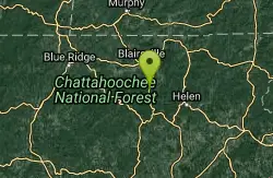
Vogle State Park
Blairsville, Georgia
33.3 miles WVogel State Park is a 233-acre or 94 hectares state park located at the base of Blood Mountain in the Chattahoochee National Forest. It became one of the first two parks in Georgia when it founded a...
Camp, Canoe, Swim
Mt. LeConte Lodge
Sylva, North Carolina
35.6 miles NHigh atop Mt. LeConte in the Great Smoky Mountains National Park, LeConte Lodge® is the highest guest lodge in the eastern United States. It is situated on an open glade just below the summit of...
Camp, Hike, Horseback, Rock Climb
Davidson River Campground
Pisgah Forest, North Carolina
44.9 miles NEDavidson River Recreation Area offers camping and outdoor activities for the whole family. The campground boasts several loops of shaded campsites, as well as access to hiking trails, fishing spots,...
Camp, Hike, Swim


