


85 Hiking Trails near Badger Creek
first prev 1 2 3 4 5 next lastShowing Hiking Trails within 50 miles Distance miles of 2480 W 10000 N, Tetonia, ID 83452, USA City, Zip, or Address

Bitch Creek Trestle
Tetonia, Idaho
6.3 miles NAs part of the Rails to Trails project, this old railroad bridge has been transformed into a very safe little viewing experience for the whole family. You can drive right up to the bridge where...
Hike 4.5 mi

Sheep Bridge Trail
Driggs, Idaho
10.7 miles SEThis is a great easy trail for beginner hikers or mountain bikers. In the early summer, you'll find many beautiful wildflowers and large kaleidoscopes of butterflies to go with them. You...
Hike, Mountain Bike 0.6 mi
Packsaddle Lake
Tetonia, Idaho
11.2 miles SWPacksaddle is one of the less well known lakes/trails in the area. If you've got a good offroad vehicle, you can probably make it all the way to the end of the road, otherwise, it's just an...
Dive, Hike, Mountain Bike, Snowshoe, Swim 4.5 mi
Aspen Trail
Alta, Wyoming
11.3 miles SEAspen Trail (tr 034) is single track trail for 4.35 miles along 6,800 ft contour to Darby Canyon (tr 012). Spring Creek Trail (tr 032) is double track trail for 3.68 miles to end. The trail starts...
Hike, Mountain Bike 3.8-6.4 mi
Table Rock / Table Mountain
Driggs, Idaho
13.7 miles SEAt 11,300 feet, Table Mountain is possibly the most beautiful climb this side of the Tetons and offers what may well be the very best view of the Grand Tetons. It's just far enough away...
Camp, Hike 15.0-18.4 mi
Alaska Basin
Driggs, Idaho
13.8 miles SEThe Alaska Basin Trail is a stunning trail through the Jedediah Wilderness near Driggs, Idaho and goes East into Wyoming, just outside of Grand Teton National Park. The trail is wide...
Backpack, Hike, Horseback 7.9 mi
Devil's Stairs
Driggs, Idaho
13.8 miles SEJust to the West of Table Rock is this often overlooked trail less traveled by, full of beautiful meadows and beautiful views all its own. The trail begins from the same campsite as the Table Rock...
Backpack, Hike 0.1-6.2 mi
Darby Wind Cave
Driggs, Idaho
15.1 miles SEDarby Wind Cave is a beautiful hike full of waterfalls, wildflowers, streams, and mountainous views. The sites you see will depend on the time of year you visit but it will always be beautiful and...
Backpack, Cave, Hike, Rock Climb 0.8 mi
Conant Creek Pegram Truss Railroad Bridge
Ashton, Idaho
15.8 miles NWAs part of the Rails to Trails project, this old railroad bridge has been transformed into a very safe little viewing experience for the whole family. You can drive right up to the bridge where there...
Hike
Mt. Moran
Alta, Wyoming
18.7 miles EMount Moran (12,610 feet (3,840 m)) is a mountain in Grand Teton National Park of western Wyoming, USA. The mountain is named for Thomas Moran, an American western frontier landscape artist....
Hike 3.2-47.0 mi
Yellowstone Branch Line Trail
Ashton, Idaho
19.6 miles NWYellowstone branch line trail runs from Warm River to the Montana border totaling 39 miles. There are a few places to jump on and off the trail as well as a few smaller trails that branch off of this...
Backpack, Cross-country Ski, Hike, Horseback, Mountain Bike 14.8-30.2 mi
Mr. Bubbles Hot Spring
Old Faithful, Yellowstone National Park
20.5 miles NMr. Bubbles is one of the few places you can actually soak in the thermal waters of Yellowstone National Park. The Bechler area of Yellowstone is one of the best kept secrets of the otherwise densely...
Hike, Hot Springs 4.9 mi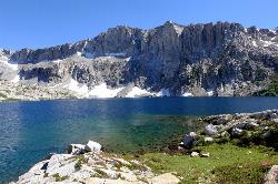
Amphitheater Lake
Alta, Wyoming
20.5 miles SEBackpack and Hike near Alta, Wyoming
Backpack, Hike 1.1 mi
Fish Lake
Ashton, Idaho
20.7 miles NEHike near Ashton, Idaho
Hike 15.9-16.6 mi
Union Falls & Ouzel Pool
Grant Village, Yellowstone National Park
20.7 miles NEBackpack, Hike, Hot Springs, and Swim near Grant Village, Yellowstone National Park
Backpack, Hike, Hot Springs, Swim
Cave Falls of Yellowstone
Ashton, Idaho
20.8 miles NThis campgrond is situated on the banks of Fall River in Wyoming along the south border of Yellowstone National Park. Cave Falls Campground has 23 single site units and a terrific area for...
Camp, Hike 0.3-5.1 mi
Jenny Lake Trail
Jackson Hole, Wyoming
21.0 miles EOne of the most popular trails to visit in Grand Teton is the Jenny Lake Trail. The Jenny Lake Trail, located near Moose, Wyoming, is an easy trail that loops around the lake. Along with the sheer...
Hike 0.3-0.6 mi
Bear Gulch
Ashton, Idaho
21.1 miles NBear Gulch is an abandoned ski hill out of operation since 1969. While the vegetation is beginning to take over, there's still some great sledding to be had. It's just far enough into the...
Camp, Cross-country Ski, Hike, Sled 0.1-7.3 mi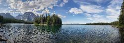
Leigh Lake
Alta, Wyoming
21.5 miles EEnjoy the grandeur of Grand Teton National Park just a little ways off the beaten path. Leigh Lake rests underneath the majestic Mount Moran. The waters of Leigh Lake flow almost directly into String...
Backpack, Canoe, Hike, Kayak 3.6 mi
String Lake
Alta, Wyoming
21.5 miles EString Lake is a shallow lake that connects Leigh Lake and Jenny Lake at the base of Mount St. John and Rockchuck Peak. From the lakeshore, you can also take in beautiful views of Teewinot and Mt....
Canoe, Hike, Kayak, Swim


