


84 Hiking Trails near Fairy Falls
first prev 1 2 3 4 5 next lastShowing Hiking Trails within 50 miles Distance miles of Fairy Falls Trailhead, Grand Loop Rd, Yellowstone National Park, WY 82190, USA City, Zip, or Address

Cave Falls of Yellowstone
Ashton, Idaho
27.0 miles SThis campgrond is situated on the banks of Fall River in Wyoming along the south border of Yellowstone National Park. Cave Falls Campground has 23 single site units and a terrific area for...
Camp, Hike 14.8-30.2 mi
Mr. Bubbles Hot Spring
Old Faithful, Yellowstone National Park
27.4 miles SWMr. Bubbles is one of the few places you can actually soak in the thermal waters of Yellowstone National Park. The Bechler area of Yellowstone is one of the best kept secrets of the otherwise densely...
Hike, Hot Springs 16.3 mi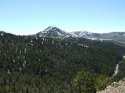
Mount Washburn Spur Trail
Canyon Village, Yellowstone National Park
27.6 miles NEWashburn Spur Trail is an exciting 8-mile trail connecting the peak of Mount Washburn to Seven Mile Hole Trail near Canyon Village. Hikers typically hike the trail starting at Mount Washburn and...
Hike 15.9-16.6 mi
Union Falls & Ouzel Pool
Grant Village, Yellowstone National Park
27.7 miles SBackpack, Hike, Hot Springs, and Swim near Grant Village, Yellowstone National Park
Backpack, Hike, Hot Springs, Swim 1.1 mi
Fish Lake
Ashton, Idaho
27.7 miles SHike near Ashton, Idaho
Hike 4.4 mi
Chittenden Road - Mount Washburn Trail
Canyon Village, Yellowstone National Park
27.7 miles NEHiking Mount Washburn via Chittenden Road is the shortest and easiest route to the top. The trail was once a service road and is now a clear well packed trail with a steady, gradual incline. The...
Hike 5.8 mi
Box Canyon Trail
Island Park, Idaho
28.5 miles WVarious species of tress and wildflowers can be seen on the trail, as well as songbirds, waterfowl and occasional wildlife. The trail is open for the following uses: Motorcycle Trail Riding, Off...
Hike, Mountain Bike 7.8 mi
Osprey Falls Trail
Mammoth Hot Springs, Yellowstone National Park
29.3 miles NOsprey Falls Trail is an 8 mile out and back trail near Mammoth Hot Springs that provides hikers with a variety of stunning views, including ravines and a waterfall. Hikers begin this hike...
Hike 4.0 mi
Bunsen Peak Trail
Mammoth Hot Springs, Yellowstone National Park
29.3 miles NBunsen Peak Trail is a 4.6 mile hike to the peak of Mount Bunsen. This is an out and back trail and is considered moderately difficult because of the 1,300 foot climb in elevation. ...
Hike 7.6 mi
Mount Jefferson
Island Park, Idaho
30.3 miles WMount Jefferson, at 10, 203 feet is the highest point in the Centennial Mountains, a small, local range on the border of Idaho and Montana a little west of Yellowstone. These mountains consist of a...
Hike 4.2 mi
Lake Marie
Island Park, Idaho
30.3 miles WLake Marie sits on the North slope of Mount Jefferson in Fremont County, Idaho. The trail to get there cuts back and forth across the Idaho Montana border 4 times. Much of the trail is fairly flat...
Backpack, Hike 0.8 mi

Wraith Falls Trail
Mammoth Hot Springs, Yellowstone National Park
31.2 miles NWraith Falls Trail is a less than 1 mile there and back hike that can be taken in under an hour. This is a wonderful family friendly hike that is easy for hikers of all levels. The hike leads...
Hike 2.0 mi
Snow Pass Trail
Yellowstone National Park Wyoming
31.2 miles NSnow Pass Trail is a beautiful day hike for visitors to Yellowstone looking to escape the crowds. Located a half mile south of the Mammoth Hot Springs Upper Terraces. Parking is available at a...
Backpack, Hike 5.3 mi
Beaver Ponds Trail
Mammoth, Yellowstone National Park
32.3 miles NBeaver Ponds Trail is a wonderful short hike accessible from Mammoth Hot Springs. The trail forms a loop between the two trailheads available at Mammoth Hot Springs. The loop is just over 5 miles...
Hike 8.1 mi
Sepulcher Mountain Trail
Mammoth Hot Springs, Yellowstone National Park
32.3 miles NSepulcher Mountain Trail is an 11 mile loop trail from Mammoth Hot Springs to the peak of Sepulcher Mountain. This is a challenging hike with a 3,500 foot ascent to the 9,652 foot peak. The...
Hike 0.1-5.2 mi
Mammoth Hot Springs
Mammoth, Yellowstone National Park
32.3 miles NMammoth Hot Springs is a unique sight in Yellowstone National Park. The soft limestone in this area allowed the water to form colorful terraces. The extremely hot running water is clear and smooth,...
Camp, Hike 4.0 mi
Lava Creek Trail
Mammoth Hot Springs, Yellowstone National Park
32.5 miles NLava Creek Trail is a 4.2 mile hike where hikers can enjoy walking along the scenic Lava Creek. The trail passes Undine Falls and the Gardner River. Undine Falls is a beautiful 60 foot...
Hike
Mammoth/Gardiner Back Road
Mammoth Hot Springs, Yellowstone National Park
32.6 miles NThe only road open in Yellowstone National Park is Highway 89 at Gardiner, Montana to park Headquarters at Mammoth Hot Springs and from Mammoth Hot Springs to Silver Gate and Cooke City, Montana.
Hike, Mountain Bike 7.4 mi
Blacktail Deer Creek to Yellowstone River Trail
Mammoth Hot Springs, Yellowstone National Park
32.6 miles NBlacktail Deer Creek Trail is a 7 mile out and back trail that leads to the Yellowstone River. Hikers on this trail will enjoy seeing green open fields, boulder formations and waterfalls at the...
Hike
Forces of the Northern Range
Mammoth, Yellowstone National Park
33.3 miles NEThis short 1/2 mile boardwalk located on the Blacktail Deer Plateau between Mammoth Village and Tower Junction will open your eyes and educate you about forces of nature that have sculpted the land...
Hike


