


60 Hiking Trails near Grove Creek Trail
first prev 1 2 3 next lastShowing Hiking Trails within 50 miles Distance miles of E Grove Creek Dr, Pleasant Grove, UT 84062, USA City, Zip, or Address

G Mountain Trail
Pleasant Grove, Utah
1.0 miles SEA family-friendly 1.5-mile roundtrip hike from Kiwanis Park to a hillside 'G' landmark near Pleasant Grove — a little steep at the start and the end, but great for all ages.
Hike 1.2 mi
Battle Creek Falls
Pleasant Grove, Utah
1.0 miles SEA short 1.2-mile family-friendly hike in Pleasant Grove to a scenic waterfall with views from below and above, plus a nearby rappelling and rock climbing area just beyond the falls.
Canyoneer, Hike 1.5 mi
Timpanogas Cave
Provo, Utah
4.7 miles NColorful cave formations — cave bacons, columns, flowstone, and drapery — inside a Timpanogos mountain cave, reached by a 1.5-mile paved trail; tours run May through September.
Backpack, Cave, Hike 1.6-14.1 mi
Mount Timpanogas
Provo, Utah
5.4 miles NEUtah's most-climbed mountain towers 7,000 feet above the Provo valley, stretching seven miles north to south with multiple peaks over 11,000 feet — a Wasatch landmark.
Camp, Hike, Horseback, Swim
Stewart Falls
Provo, Utah
5.8 miles EA glacier-fed, 200-foot multi-tiered waterfall on Mt. Timpanogos — about a 4-mile round trip hike through forest with a few steep edges near the falls.
Hike
Timpanogos Falls
Provo, Utah
6.0 miles EA lesser-known multi-tiered waterfall on the Mt. Timpanogos trail, visible early on and surrounded by wildflowers in late spring — a great beginner hike shared with the Stewart Falls trailhead.
Hike

Provo River Parkway Trail
Provo, Utah
7.3 miles EA fully paved 6-mile canyon ride from Vivian Park to the mouth of Provo Canyon, passing waterfalls and a fish-feeding spot — best done with two cars for a car-shuttle downhill.
Hike, Mountain Bike 1.7 mi
Schoolhouse Springs Trail
Alpine, Utah
7.8 miles NA short, scenic trail at 5,300 feet in Alpine, Utah, featuring a lake and activities from horseback riding to hiking — best enjoyed between May and October.
Hike, Mountain Bike
Mercer Hollow Trail
Draper, Utah
9.3 miles NWA fast, flowy descent on the southern flank of Corner Canyon Ridge, packed with berms, rock features, rollers, and a quick uphill that rewards you on the way back down.
Hike, Mountain Bike 1.3 mi
Eagle Crest Trail
Draper, Utah
9.4 miles NWA beginner-level 2.4-mile mountain bike trail along the north side of Traverse Mountain in Draper, with sweeping views of Salt Lake Valley, Mount Timpanogos, Lone Peak, and Box Elder Mountain.
Hike, Mountain Bike 1.7 mi
Jacob's Ladder Trail
Sandy, Utah
9.9 miles NWJacob's Ladder is the steep, relentless local favorite for climbing into the Lone Peak Wilderness above Draper, Utah — and a legendary technical descent.
Hike, Mountain Bike 0.2-1.8 mi
Lone Peak
Draper, Utah
10.0 miles NWOne of the Wasatch Front's taller peaks at over 11,000 feet, Lone Peak offers five different trailhead approaches, a 9-mile average round trip, rugged canyon terrain, and stunning Salt Lake valley views.
Hike, Mountain Bike, Rock Climb 1.2 mi
Ghost Falls Trail
Sandy, Utah
10.0 miles NWA family-friendly hike in Corner Canyon that winds through sandy rocky slopes and dry creek beds to the Ghost Falls loop, with helpful trail signs at the confusing intersections.
Hike, Mountain Bike, Snowshoe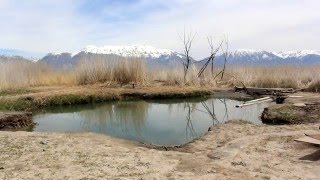
Saratoga Hot Springs
Saratoga Springs, Utah
10.1 miles WThree naturally heated pools around 100°F year-round, a muddy beautiful setting, and an easy walk to nearby Utah Lake for wildlife watching between soaks.
Hike, Hot Springs
Y-Mountain Summit Trail
Provo, Utah
10.5 miles SEA 1.2-mile climb east of BYU leads to a massive block Y on the hillside and sweeping panoramas over Provo, Orem, Utah Valley, and Utah Lake below.
Camp, Hike
Little Valley Trail
Draper, Utah
10.6 miles NWSuperbly constructed flow trails in a small Draper valley that are just as fun for adults as for kids — with connections to Corner Canyon for a longer ride.
Hike, Mountain Bike 0.6 mi
Potato Hill Trail
Draper, Utah
10.6 miles NWA short, paved trail system in Draper that connects Potato Hill to the Bonneville Shoreline Trail — combine with Red Potato and Lexie and Ethan trails for a 3-mile loop with smooth climbing.
Hike, Mountain Bike 0.8 mi
Red Rock Trail
Draper, Utah
11.0 miles NWA one-mile cliff-edge loop delivers sweeping Salt Lake Valley views and beginner-to-intermediate rock climbing on five walls with dental-themed route names.
Hike, Mountain Bike, Rock Climb 0.6 mi
Bst To Equestrian Center Loop
Draper, Utah
11.5 miles NWA 10-mile intermediate singletrack loop in Draper connecting the Bonneville Shoreline Trail and Equestrian Center with 417 feet of elevation along varied terrain.
Hike, Mountain Bike 1.6 mi
Corner Canyon Trail
Draper, Utah
11.5 miles NWA go-to mountain biking area in South Salt Lake mixing beginner training trails in Little Valley with big table tops and wall rides in Maple Hollow.
Backpack, Hike, Mountain Bike


