


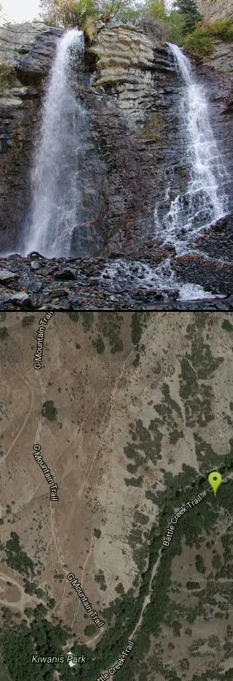
Battle Creek Falls
Pleasant Grove, Utah

| GPS: |
40°21'46.7"N 111°42'2.3"W Maps | Directions |
| State: | Utah |
| Trails/Routes: | 1.2 mi |
Canyoneer and Hike
Battle Creek Falls, located near Pleasant Grove, Utah, is a scenic waterfall that also has a rappelling and rock climbing area nearby. Hikers are allowed to see the falls from two view points, below and above the falls, if hikers are willing to hike beyond the falls. The Battle Creek Falls trail head start at Kiwanis Park in Pleasant Grove where hikers take a short hike to the falls. The canyon area is beautiful and the trail is very wide allowing for many hikers to hike up to and come back from the falls at a time.
The trail is accessible year round but the best times to hike the trail are from April to October because the trail gets icy in winter months (although Battle Creek Falls is beautiful when frozen over). The trail is about 1.2 miles and is an out and back style trail. Hikers have the option to keep going up Battle Creek Canyon if they wish to get some steep climbs in for the day. The hike is very easy and is very family friendly with lots of great spots to take pictures.
Locals and visitors alike enjoy Battle Creek Falls for its majestic beauty and fun, easy hiking. If you and your family are looking for an activity to do together Battle Creek Falls could be exactly what you are looking for.
More Information
Battle Creek Falls
Located in the foothills of the massive west face of Mount Timpanogos, Battle Creek Falls is a short hike to a 50 foot waterfall, that children of all ages will enjoy. The fact that it is only minu…
https://www.yourhikeguide.com/battle-creek-falls/Battle Creek Falls
From the trailhead, just follow the obvious hiker trail into the canyon. The trail stays in the bottom of the canyon, along the stream, for most of the way, but it climbs up onto the bench as you approach the waterfall. You can easily hike down to the base of the waterfall, or continue up the canyon for several more miles. You return the way you came in.
https://www.utah.com/destinations/cities-towns/provo/hiking/battle-creek-falls/Be courteous, informed, and prepared. Read trailhead guidelines, stay on the trail, and don't feed the wildlife.
Read More- Plan Ahead and Prepare
- Travel & camp on durable surfaces
- Dispose of waste properly
- Leave what you find
- Minimize campfire impacts
- Respect wildlife
- Be considerate of other visitors
Directions
From Pleasant Grove, Utah
- Head east on E Center St toward S 200 E (0.1 mi)
- Turn right at the 2nd cross street onto S 300 E St (0.2 mi)
- Turn left at the 2nd cross street onto E 200 SDestination will be on the right(1.9 mi)
The trailhead is easy to find. From the town of Pleasant Grove, just follow 200 S to the east side of town. The street is also known as Battle Creek Drive and it dead-ends at the trailhead.
To the falls:
From the trailhead, just follow the obvious hiker trail into the canyon. The trail stays in the bottom of the canyon, along the stream, for most of the way, but it climbs up onto the bench as you approach the waterfall. You can easily hike down to the base of the waterfall, or continue up the canyon for several more miles. You return the way you came in.


Other Hiking Trails and Canyons Nearby

G Mountain Trail
Pleasant Grove, Utah
0.0 miles WA family-friendly 1.5-mile roundtrip hike from Kiwanis Park to a hillside 'G' landmark near Pleasant Grove — a little steep at the start and the end, but great for all ages.
Hike
Grove Creek Trail
Pleasant Grove, Utah
1.0 miles NWA steep, shuttled downhill singletrack dropping from the shoulder of Mount Timpanogos through Grove Creek Canyon — the climb is brutal, but the descent is worth it.
Hike, Mountain Bike 1.5 mi
Timpanogas Cave
Provo, Utah
5.6 miles NColorful cave formations — cave bacons, columns, flowstone, and drapery — inside a Timpanogos mountain cave, reached by a 1.5-mile paved trail; tours run May through September.
Backpack, Cave, Hike 1.6-14.1 mi
Mount Timpanogas
Provo, Utah
5.7 miles NEUtah's most-climbed mountain towers 7,000 feet above the Provo valley, stretching seven miles north to south with multiple peaks over 11,000 feet — a Wasatch landmark.
Camp, Hike, Horseback, Swim
Stewart Falls
Provo, Utah
5.8 miles NEA glacier-fed, 200-foot multi-tiered waterfall on Mt. Timpanogos — about a 4-mile round trip hike through forest with a few steep edges near the falls.
Hike
Timpanogos Falls
Provo, Utah
5.9 miles NEA lesser-known multi-tiered waterfall on the Mt. Timpanogos trail, visible early on and surrounded by wildflowers in late spring — a great beginner hike shared with the Stewart Falls trailhead.
Hike
Provo River Parkway Trail
Provo, Utah
6.7 miles EA fully paved 6-mile canyon ride from Vivian Park to the mouth of Provo Canyon, passing waterfalls and a fish-feeding spot — best done with two cars for a car-shuttle downhill.
Hike, Mountain Bike 1.7 mi
Schoolhouse Springs Trail
Alpine, Utah
8.8 miles NA short, scenic trail at 5,300 feet in Alpine, Utah, featuring a lake and activities from horseback riding to hiking — best enjoyed between May and October.
Hike, Mountain Bike
Y-Mountain Summit Trail
Provo, Utah
9.5 miles SEA 1.2-mile climb east of BYU leads to a massive block Y on the hillside and sweeping panoramas over Provo, Orem, Utah Valley, and Utah Lake below.
Camp, Hike
Mercer Hollow Trail
Draper, Utah
10.3 miles NWA fast, flowy descent on the southern flank of Corner Canyon Ridge, packed with berms, rock features, rollers, and a quick uphill that rewards you on the way back down.
Hike, Mountain Bike 1.3 mi
Eagle Crest Trail
Draper, Utah
10.4 miles NWA beginner-level 2.4-mile mountain bike trail along the north side of Traverse Mountain in Draper, with sweeping views of Salt Lake Valley, Mount Timpanogos, Lone Peak, and Box Elder Mountain.
Hike, Mountain Bike
Saratoga Hot Springs
Saratoga Springs, Utah
10.5 miles WThree naturally heated pools around 100°F year-round, a muddy beautiful setting, and an easy walk to nearby Utah Lake for wildlife watching between soaks.
Hike, Hot Springs
Bicentennial Park
Provo, Utah
10.9 miles SA 16-hole disc golf course in Provo beside a duck pond, a playground, a boardwalk nature trail with natural springs, and mature trees that make even moderate holes a genuine challenge.
Disc Golf, Hike, Sled 1.7 mi
Jacob's Ladder Trail
Sandy, Utah
10.9 miles NWJacob's Ladder is the steep, relentless local favorite for climbing into the Lone Peak Wilderness above Draper, Utah — and a legendary technical descent.
Hike, Mountain Bike 0.2-1.8 mi
Lone Peak
Draper, Utah
10.9 miles NWOne of the Wasatch Front's taller peaks at over 11,000 feet, Lone Peak offers five different trailhead approaches, a 9-mile average round trip, rugged canyon terrain, and stunning Salt Lake valley views.
Hike, Mountain Bike, Rock Climb 1.2 mi
Ghost Falls Trail
Sandy, Utah
11.0 miles NWA family-friendly hike in Corner Canyon that winds through sandy rocky slopes and dry creek beds to the Ghost Falls loop, with helpful trail signs at the confusing intersections.
Hike, Mountain Bike, Snowshoe
Little Valley Trail
Draper, Utah
11.6 miles NWSuperbly constructed flow trails in a small Draper valley that are just as fun for adults as for kids — with connections to Corner Canyon for a longer ride.
Hike, Mountain Bike 0.6 mi
Potato Hill Trail
Draper, Utah
11.6 miles NWA short, paved trail system in Draper that connects Potato Hill to the Bonneville Shoreline Trail — combine with Red Potato and Lexie and Ethan trails for a 3-mile loop with smooth climbing.
Hike, Mountain Bike 0.8 mi
Red Rock Trail
Draper, Utah
11.9 miles NWA one-mile cliff-edge loop delivers sweeping Salt Lake Valley views and beginner-to-intermediate rock climbing on five walls with dental-themed route names.
Hike, Mountain Bike, Rock Climb
White Pine Lake
Sandy, Utah
12.4 miles NA canyon that ski resort lobbyists fought to keep out of wilderness, now open to hikers and rare mountain bikers — hike in and discover why everyone has been arguing over White Pine Canyon.
Hike, Mountain BikeNearby Campsites
Mount Timpanogas
Provo, Utah
5.7 miles NEUtah's most-climbed mountain towers 7,000 feet above the Provo valley, stretching seven miles north to south with multiple peaks over 11,000 feet — a Wasatch landmark.
Camp, Hike, Horseback, Swim
Y-Mountain Summit Trail
Provo, Utah
9.5 miles SEA 1.2-mile climb east of BYU leads to a massive block Y on the hillside and sweeping panoramas over Provo, Orem, Utah Valley, and Utah Lake below.
Camp, Hike
Spruces Campground
Salt Lake City, Utah
19.5 miles NA fee campground in Big Cottonwood Canyon near Salt Lake City — check USDA.gov for current rates and seasonal availability.
Camp, Sled
Mill Creek Canyon
Salt Lake City, Utah
23.3 miles NAn out-and-back canyon trail with over 1,000 feet of elevation gain — the lower ski trail sees heavy traffic while the upper section above Elbow Fork stays quiet, with a reservable Yurt at the top December through April.
Camp, Cross-country Ski, Snowshoe 4.7 mi
Fifth Water Hot Springs
Provo, Utah
26.5 miles SEA scenic 2.5-mile riverside hike to the famous Diamond Fork rock pools and waterfall, with soaks up to 108°.
Backpack, Camp, Hike, Hot Springs, Mountain Bike, Swim
Holbrook Trailhead
Bountiful, Utah
36.6 miles NThe Holbrook Trailhead is a popular access point for the Bonneville Shoreline Trail and Holbrook Canyon above Bountiful, Utah, on the western face of the Wasatch. Perched on the bench right at the...
Airsoft, Backpack, Camp, Paintball, Snowshoe


