


Grove Creek Trail
Pleasant Grove, Utah

Hike and Mountain Bike
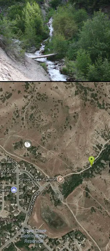
The Grove Creek Trail is a steep, scenic canyon hike rising right from the edge of Pleasant Grove, Utah, into the rugged high country on the west face of Mount Timpanogos in the Uinta-Wasatch-Cache National Forest. A popular local favorite for hikers and trail runners, it climbs quickly out of the valley into a narrow, dramatic canyon with waterfalls and big views over Utah Valley.
From the trailhead at the end of Grove Creek Drive, the path wastes no time gaining elevation as it works up the tight canyon. Along the way it passes two waterfalls — best admired from the trail, which looks right down onto them — and reaches a bridge crossing the creek near the top of the second falls, where a bench makes a perfect turnaround and rest spot at about 4 miles round trip (1,500 feet of gain). Ambitious hikers can continue to Indian Springs Campground (roughly 6 miles round trip, 2,200 feet) or link into the Great Western Trail for longer adventures.
Because the trail is narrow, steep, and exposed, take care with footing, and note there's essentially zero shade — so avoid it in the heat of the day and carry plenty of water. Dogs are allowed and are often off-leash here. Spring brings the fullest waterfalls (and the trail can be muddy or icy in shoulder seasons).
Come with sturdy shoes, sun protection, and water, start early on hot days, and pack out everything. For a big workout and a big payoff close to town, the Grove Creek Trail is one of Utah Valley's classics.
More Information
Grove Creek DH Trail - Ultimate Guide to Mountain Biking in Utah
Grove Creek (Pleasant Grove). Up-and-back or downhill trail for advanced riders. (Most riders do this ride as a shuttled DH.) Fairly steep, exposed cliffsides, trail surface often technical. This page covers shuttled downhill version. Uphill instructions covered on Big Baldy Loop trail page. Season June through September.
https://utahmountainbiking.com/trails/GroveCreek/Grove Creek, A Timpanogos side hike. : Trip Reports : SummitPost
Grove Creek, A Timpanogos side hike. : SummitPost.org : Climbing, hiking, mountaineering
https://www.summitpost.org/grove-creek-a-timpanogos-side-hike/169930Hike of the week: Grove Creek Trail - Utah County – Deseret News
See More Deseret News Stories In SearchView CommentsShareView 14 moreOn the trail, hikers can see Utah Lake down Grove Creek Canyon. Photo courtesy of Bruce Moore View 14 more1. Grove Creek Canyon parking lot and trailhead above Pleasant Grove. Steve Baker, Deseret News View 14 more2. There is a trail map and information board at the start of the hike. Steve Baker, Deseret News View 14 more3. The hiking group heads into Grove Creek Canyon. Photo courtesy of Bruce Moore View 14 more4.This is the first switchback, which takes hikers away from the creek and above it. Steve Baker, Deseret News View 14 more5. The trail goes high above the creek as hikers make their way to the upper waterfall. Photo courtesy of Bruce Moore View 14 more6. The hiking group stops on the trail to view Grove Creek Canyon. Photo courtesy of Bruce Moore View 14 more7. On the trail, hikers pause on the ledge. Photo courtesy of Bruce Moore View 14 more8. The hikers continue on the ledge for the waterfall. Sections of the trail are carved out of the mountain. Photo courtesy of Bruce Moore View 14 more9. The trail clings to the mountainside with dropoffs. Photo courtesy of Bruce Moore View 14 more10. A hiker stands on a rocky edge to view the canyon. There are many dropoffs on the trail to the waterfall. Photo courtesy of Bruce Moore View 14 more11. The lower waterfall in Grove Creek Canyon. Photo courtesy of Bruce Moore View 14 more12. View looking down Grove Creek Canyon. Photo courtesy of Bruce Moore View 14 more13. The upper waterfall from the trail. Photo courtesy of Bruce Moore View 14 more14. View looking down Grove Creek Canyon from the upper waterfall. There is a sitting bench to relax and enjoy the view. Photo courtesy of Bruce Moore By Deseret NewsYour browser does not support the audio element.Play audioNEW: Try Article AudioNEW: Try Article AudioAudio quality:|Skip back 15 secondsPlay audioSkip forward 15 seconds00:0000:00Decrease playback rate1.0xIncrease playback rate00:00/00:00Skip back 15 secondsPlay audioSkip forward 15 seconds-0.5x0.6x0.7x0.8x0.9x1.0x1.1x1.2x1.3x1.4x1.5x1.6x1.7x1.8x1.9x2.0x2.1x2.2x2.3x2.4x2.5x2.6x2.7x2.8x2.9x3.0x+About halfway up the trail, sections cling to the mountainside. If a few drop-offs don't bother you, your adventure in Grove Creek Canyon awaits you. The trail starts on the bench above Pleasant Grove. This trail offers little shade, so start early and take plenty of water. At the trailhead is an information board and map of the area. Start on the trail, and at .32 mile, stay left at the first split. The trail goes up and enters small scrub oaks near the creek. With the sounds of rushing water, the trail switchbacks away from it at .64 mile. On the switchback, the trail opens to western views of Utah Valley and Utah Lake. Quickly, you switch back into the canyon at .93 mile. Keep to the right in this area. The trail becomes more exciting as it clings to the mountainside at 1.20 miles. The trail is safe, but pay close attention to your footing as you snake around the mountain. After crossing a scree field and golden-colored spring, watch for the first waterfall below you. At two miles, the trail opens to the upper waterfall. Take a seat on the sitting bench, and enjoy the beautiful view looking down Grove Creek Canyon. This hike isn't recommended for families with small children.
https://www.deseret.com/2010/7/7/20126529/hike-of-the-week-grove-creek-trail-utah-county/The Salt Lake Tribune
Utah's independent nonprofit news source covers news, politics, faith, arts and sports for Salt Lake City and Utah. Read Pulitzer Prize-winning journalism.
https://sltrib.com/Never modify trail features. Ride trails when they're dry enough that you won't leave ruts. Speak up when you see others on the trail and always yield to hikers, horses, and others coming uphill. Always ride on the established trail.
Read MoreBe courteous, informed, and prepared. Read trailhead guidelines, stay on the trail, and don't feed the wildlife.
Read More- Plan Ahead and Prepare
- Travel & camp on durable surfaces
- Dispose of waste properly
- Leave what you find
- Minimize campfire impacts
- Respect wildlife
- Be considerate of other visitors
Directions
From Pleasant Grove, Utah
- Head west on E Center St toward N 100 E (89 ft)
- Turn right at the 1st cross street onto N 100 E (0.4 mi)
- Turn right onto E 500 N/Grove Creek DrContinue to follow Grove Creek Dr(1.6 mi)
Backtrack to 100 East in Pleasant Grove. Turn right (north) and follow the Canyon Highway to the mouth of American Fork Canyon. Keep right and head up the canyon. Five miles later at the fork in the road, go along the south fork of the river. About 4 miles up, there's a T in the road. Turn right into the Timpooneke Campground road. Keep going until it turns to gravel, and go another 5 miles. Watch for the Grove Creek Trail sign on your right for the short trailhead; go another 1/2 mile for the full ride.


Other Mountain Bike Trails and Hiking Trails Nearby
Bonneville Shoreline Trail - Cedar Hills to Grove Creek Canyon
Pleasant Grove, Utah
0.1 miles SWA 3-mile intermediate mountain bike trail along the Bonneville Shoreline, connecting Cedar Hills to Grove Creek Canyon — mostly flat with some singletrack and a few intersecting routes near construction.
Mountain Bike
G Mountain Trail
Pleasant Grove, Utah
1.0 miles SEA family-friendly 1.5-mile roundtrip hike from Kiwanis Park to a hillside 'G' landmark near Pleasant Grove — a little steep at the start and the end, but great for all ages.
Hike 1.2 mi
Battle Creek Falls
Pleasant Grove, Utah
1.0 miles SEA short 1.2-mile family-friendly hike in Pleasant Grove to a scenic waterfall with views from below and above, plus a nearby rappelling and rock climbing area just beyond the falls.
Canyoneer, Hike 1.5 mi
Timpanogas Cave
Provo, Utah
4.7 miles NColorful cave formations — cave bacons, columns, flowstone, and drapery — inside a Timpanogos mountain cave, reached by a 1.5-mile paved trail; tours run May through September.
Backpack, Cave, Hike
South Fork of the Provo
Provo, Utah
4.9 miles SEA fun, short, scenic singletrack ride on the South Fork of the Provo — ideal for introducing new riders to mountain biking, with a loop at the end and an optional extension past Big Spring.
Mountain Bike
Timpanooke
Provo, Utah
5.4 miles NEAn intermediate trail through pine forests and grass meadows on the Great Western Trail near Provo — creek crossings, a steep summit climb, and a fun downhill back to the trailhead.
Mountain Bike 1.6-14.1 mi
Mount Timpanogas
Provo, Utah
5.4 miles NEUtah's most-climbed mountain towers 7,000 feet above the Provo valley, stretching seven miles north to south with multiple peaks over 11,000 feet — a Wasatch landmark.
Camp, Hike, Horseback, Swim
Stewart Falls
Provo, Utah
5.8 miles EA glacier-fed, 200-foot multi-tiered waterfall on Mt. Timpanogos — about a 4-mile round trip hike through forest with a few steep edges near the falls.
Hike
Timpanogos Falls
Provo, Utah
6.0 miles EA lesser-known multi-tiered waterfall on the Mt. Timpanogos trail, visible early on and surrounded by wildflowers in late spring — a great beginner hike shared with the Stewart Falls trailhead.
Hike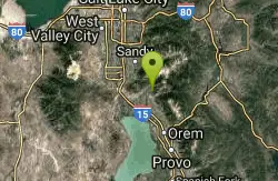
Rodeo Down
Alpine, Utah
6.1 miles NA dense network of named mountain bike trails in Alpine — Black Dog, Brown Dog, Corkscrew, Flank, and more — with varied technical character, rock stunts, and elevation changes up to 300 feet.
Mountain Bike
Bear Canyon Loop
Provo, Utah
6.2 miles NEAn advanced 8.4-to-longer-mile mountain biking loop through forested Wasatch switchbacks with 1,700 ft of elevation gain, steep rocky sections, and dramatic views from the ridge.
Mountain Bike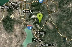
Ridge Trail #157
Provo, Utah
6.3 miles NEA 15.7-mile backbone trail in American Fork Canyon connecting multiple loop routes, with excellent views throughout and increasingly demanding terrain north of Mill Canyon — some of the best singletrack in the Wasatch.
Mountain Bike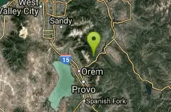
Archie's Loop
Sundance, Utah
7.0 miles EA 2.2-mile intermediate mountain bike and hiking trail near Sundance with panoramic views of Mt. Timpanogos, Provo Canyon, Deer Creek Reservoir, and the Heber Valley.
Mountain Bike
Provo River Parkway Trail
Provo, Utah
7.3 miles EA fully paved 6-mile canyon ride from Vivian Park to the mouth of Provo Canyon, passing waterfalls and a fish-feeding spot — best done with two cars for a car-shuttle downhill.
Hike, Mountain Bike 1.7 mi
Schoolhouse Springs Trail
Alpine, Utah
7.8 miles NA short, scenic trail at 5,300 feet in Alpine, Utah, featuring a lake and activities from horseback riding to hiking — best enjoyed between May and October.
Hike, Mountain Bike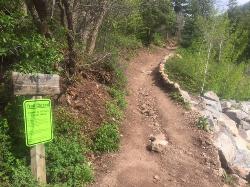
Tibble Fork
Provo, Utah
8.0 miles NEAn advanced and aerobic mountain bike ride out of Provo that climbs brutally through pine forests to the Great Western Trail, then drops 2,000 feet over 3 miles back to the trailhead.
Mountain Bike
Mercer Hollow Trail
Draper, Utah
9.3 miles NWA fast, flowy descent on the southern flank of Corner Canyon Ridge, packed with berms, rock features, rollers, and a quick uphill that rewards you on the way back down.
Hike, Mountain Bike 1.3 mi
Eagle Crest Trail
Draper, Utah
9.4 miles NWA beginner-level 2.4-mile mountain bike trail along the north side of Traverse Mountain in Draper, with sweeping views of Salt Lake Valley, Mount Timpanogos, Lone Peak, and Box Elder Mountain.
Hike, Mountain Bike 1.7 mi
Jacob's Ladder Trail
Sandy, Utah
9.9 miles NWJacob's Ladder is the steep, relentless local favorite for climbing into the Lone Peak Wilderness above Draper, Utah — and a legendary technical descent.
Hike, Mountain Bike 0.2-1.8 mi
Lone Peak
Draper, Utah
10.0 miles NWOne of the Wasatch Front's taller peaks at over 11,000 feet, Lone Peak offers five different trailhead approaches, a 9-mile average round trip, rugged canyon terrain, and stunning Salt Lake valley views.
Hike, Mountain Bike, Rock ClimbNearby Campsites
Mount Timpanogas
Provo, Utah
5.4 miles NEUtah's most-climbed mountain towers 7,000 feet above the Provo valley, stretching seven miles north to south with multiple peaks over 11,000 feet — a Wasatch landmark.
Camp, Hike, Horseback, Swim
Y-Mountain Summit Trail
Provo, Utah
10.5 miles SEA 1.2-mile climb east of BYU leads to a massive block Y on the hillside and sweeping panoramas over Provo, Orem, Utah Valley, and Utah Lake below.
Camp, Hike
Spruces Campground
Salt Lake City, Utah
18.7 miles NA fee campground in Big Cottonwood Canyon near Salt Lake City — check USDA.gov for current rates and seasonal availability.
Camp, Sled
Mill Creek Canyon
Salt Lake City, Utah
22.4 miles NAn out-and-back canyon trail with over 1,000 feet of elevation gain — the lower ski trail sees heavy traffic while the upper section above Elbow Fork stays quiet, with a reservable Yurt at the top December through April.
Camp, Cross-country Ski, Snowshoe 4.7 mi
Fifth Water Hot Springs
Provo, Utah
27.5 miles SEA scenic 2.5-mile riverside hike to the famous Diamond Fork rock pools and waterfall, with soaks up to 108°.
Backpack, Camp, Hike, Hot Springs, Mountain Bike, Swim
Holbrook Trailhead
Bountiful, Utah
35.7 miles NThe Holbrook Trailhead is a popular access point for the Bonneville Shoreline Trail and Holbrook Canyon above Bountiful, Utah, on the western face of the Wasatch. Perched on the bench right at the...
Airsoft, Backpack, Camp, Paintball, Snowshoe


