


Stewart Falls
Provo, Utah

| Address: | Stewart Falls Trail, Provo, UT 84604, USA |
| GPS: |
40°24'15.2"N 111°36'19.7"W Maps | Directions |
| State: | Utah |
Waterfalls Streams Trails
Hike
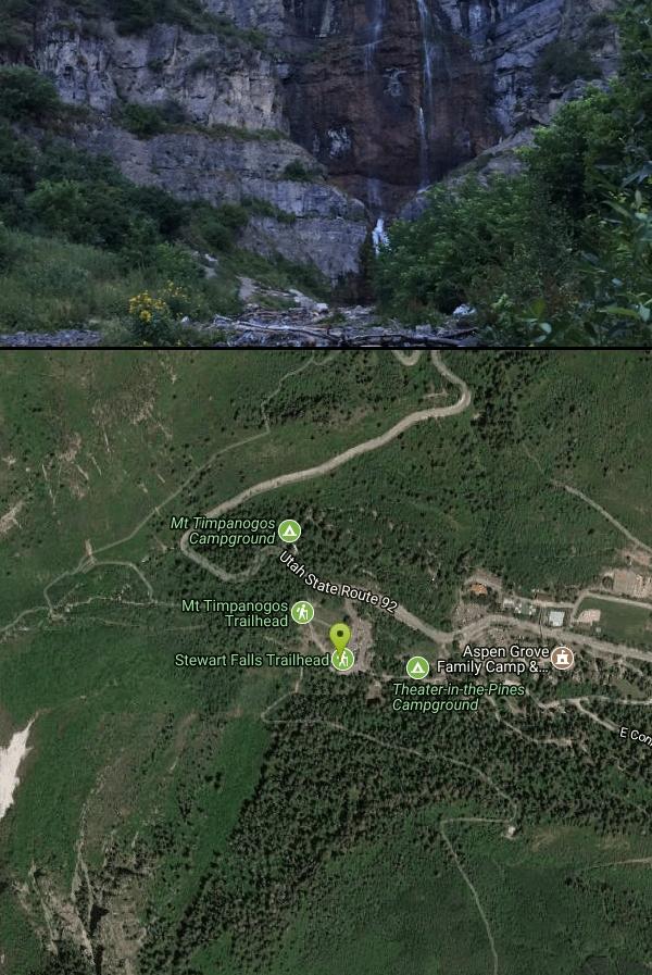
Stewart Falls is found nestled in the forest along the east side of Mt. Timpanogos. Fed by a glacier on the mountain, the crystal clear falls will leave visitors refreshed on a warm summer day. Those hiking in to see the waterfall will be stunned at the 200 ft, multi-tiered waterfall, making it one of the most photographed waterfalls in the area. The hike is about 4 miles round trip and is not too strenuous. There are a few steep edges, so be sure to keep children in sight and close by. The trail is closed when there is snow, so the best time to visit is in the summer or fall, with fall being exceptionally beautiful from all the changing leaves.
Be courteous, informed, and prepared. Read trailhead guidelines, stay on the trail, and don't feed the wildlife.
Read More- Plan Ahead and Prepare
- Travel & camp on durable surfaces
- Dispose of waste properly
- Leave what you find
- Minimize campfire impacts
- Respect wildlife
- Be considerate of other visitors
Directions
From Provo, Utah
- Head west on E Center St toward N University Ave (46 ft)
- Turn right at the 1st cross street onto N University Ave (4.7 mi)
- Continue onto US-189 N/N University AveContinue to follow US-189 N(7.6 mi)
- Turn left onto UT-92 W (4.8 mi)
- Turn left (180 ft)
- Turn left (397 ft)
If coming from Sundance Ski Resort, you can take a ski lift up to Ray's Summit, cutting down on some of the hiking time. This option does charge, Adults $11, children 6-12 $9, and children under 5 are free.


Other Hiking Trails Nearby

Timpanogos Falls
Provo, Utah
0.1 miles EOne of the many waterfalls in the Mt Timpanogos area, Timpanogos Falls is a lesser known and visited waterfall. The trail for Timpanogos Falls departs from the same parking lot as Stewart Falls,...
Hike 1.6-14.1 mi
Mount Timpanogas
Provo, Utah
2.6 miles NWMt. Timp, as the locals call it, is the 2nd highest mountain in the Wasatch range (only Mt. Nebo is higher). What sets "Timp" apart is its location. It towers over the Provo, Orem, Pleasant...
Camp, Hike, Horseback, Swim
Provo River Parkway Trail
Provo, Utah
3.8 miles SEThis isn't quite as much mountain biking as it is an easy downhill bike ride. The whole trail is paved. One of the best ways to do it is to take two vehicles and park one at Will's Canyon...
Hike, Mountain Bike 1.2 mi
Battle Creek Falls
Pleasant Grove, Utah
5.8 miles SWBattle Creek Falls, located near Pleasant Grove, Utah, is a scenic waterfall that also has a rappelling and rock climbing area nearby. Hikers are allowed to see the falls from two view points, below...
Canyoneer, Hike
G Mountain Trail
Pleasant Grove, Utah
5.8 miles SWThe trail starts at Kiwanis Park which is south of the 'G' at the end of Battle Creek Road. The trail starts out a little steep for about .25 mile and the very last bit is a...
Hike
Grove Creek Trail
Pleasant Grove, Utah
5.8 miles WThe Grove Creek Trail falls from the upper shoulder of Mount Timpanogos down Grove Creek Canyon to Pleasant Grove. It's usually ridden as a shuttled downhill -- because the climb up this...
Hike, Mountain Bike 1.5 mi
Timpanogas Cave
Provo, Utah
6.0 miles NWKnown for it's colorful cave decorations, the Timpanogas cave attracts numerous visitors per year, is steep but it's paved so that visitors can access the cave. To access the cave, visitors...
Backpack, Cave, Hike 1.7 mi
Schoolhouse Springs Trail
Alpine, Utah
9.7 miles NWSchoolhouse Springs trail has an elevation trail at 5,300 ft. It's located at the end of the town of Alpine. It features a lake and there's a number of activities including horse-back...
Hike, Mountain Bike
White Pine Lake
Sandy, Utah
10.3 miles NWhite Pine Canyon has long been the subject of intense controversy between advocates of wilderness and ski resort owners. The original boundaries of Lone Peak Wilderness Area, created in 1977, were...
Hike, Mountain Bike
American Fork Twin Peaks
Provo, Utah
10.5 miles NAmerican Fork Twin Peaks is the highest mountain on the Little Cottonwood Canyon ridge. The summit is the prominent peak overlooking the Snowbird ski resort. A short approach hike...
Hike
Y-Mountain Summit Trail
Provo, Utah
10.9 miles SY Mountain is located directly east of Brigham Young University (BYU) in Provo, Utah, United States. The Slide Canyon/Y Mountain Trail leads to a large block Y located 1.2 miles (1.9 km) from a...
Camp, Hike
Sugarloaf Peak
Alta, Utah
11.2 miles NSugarloaf Peak is an easily reached 11,000 ft. summit which overlooks Albion Basin, Secret Lake, and much of Utah's Alta ski resort. The easy terrain and relatively high trailhead elevation...
Hike
Cecret (Secret) Lake
Alta, Utah
11.6 miles NCecret (pronounced "Secret") Lake is a beautiful lake located among alpine meadows in Little Cottonwood Canyons Albion Basin. Some folks spell Secret Lake as Cecret Lake, but the USGS...
Hike
Pfeiferhorn Peak
Provo, Utah
12.5 miles NThe Pfeifferhorn is a majestic peak, which is located east of Salt Lake City, Utah in the Wasatch mountain range. It's easy access, proximity to alpine lakes and short trail make it a popular...
Backpack, Hike
Mercer Hollow Trail
Draper, Utah
12.6 miles NWMercer Hollow Trail is primarily used to bomb down the southern flanks of the ridge the Corner Canyon Trails sit on. It's filled with berms, rock features, rollers, and sweet, sweet...
Hike, Mountain Bike 1.7 mi
Jacob's Ladder Trail
Sandy, Utah
12.7 miles NWJacobs Ladder trail has an elevation trail of 5,700 ft. and the most popular trailhead out of the five trails in Lone Peak. It's located near a large area on the right side of the road...
Hike, Mountain Bike 0.2-1.8 mi
Lone Peak
Draper, Utah
12.7 miles NWEstablished in 1978 and located southeast of Salt Lake, Lone Peak is one of the taller peaks in the Wasatch range along the Wasatch Front. It has 5 main trailheads: Jacobs Ladder via Corner Canyon...
Hike, Mountain Bike, Rock Climb 1.2 mi
Ghost Falls Trail
Sandy, Utah
12.8 miles NWGhost Falls is located in the corner canyon riding area of Draper, Utah and one of the first mountain bike routes in the canyon. It's a family-friendly hike, named for the...
Hike, Mountain Bike, Snowshoe 1.3 mi
Eagle Crest Trail
Draper, Utah
13.0 miles WEagle Crest trail is a beginner level trail mountain bike in Draper, Utah along the north side of Traverse Mountain. From the trail, riders can see the Salt Lake Valley, the Northern end of Utah...
Hike, Mountain Bike
Bicentennial Park
Provo, Utah
13.2 miles SBicentennial Park is a favorite among disc golfers and families in the Provo area. The park has a 16-hole golf course, a duck pond, a playground, and a nature trail which features natural springs...
Disc Golf, Hike, SledNearby Campsites
Mount Timpanogas
Provo, Utah
2.6 miles NWMt. Timp, as the locals call it, is the 2nd highest mountain in the Wasatch range (only Mt. Nebo is higher). What sets "Timp" apart is its location. It towers over the Provo, Orem, Pleasant...
Camp, Hike, Horseback, Swim
Y-Mountain Summit Trail
Provo, Utah
10.9 miles SY Mountain is located directly east of Brigham Young University (BYU) in Provo, Utah, United States. The Slide Canyon/Y Mountain Trail leads to a large block Y located 1.2 miles (1.9 km) from a...
Camp, Hike
Spruces Campground
Salt Lake City, Utah
16.5 miles NCamping isn't free. See USDA.gov for details. If you know the coordinates of the sledding hill here, please comment.
Camp, Sled
Mill Creek Canyon
Salt Lake City, Utah
21.2 miles NMill Creek is an out and back with over 1000 ft of elevation gain. The lower section of the ski trail gets a lot of foot traffic, but the upper section (above Elbow Fork) is generally very quiet....
Camp, Cross-country Ski, Snowshoe 4.7 mi
Fifth Water Hot Springs
Provo, Utah
25.8 miles SEAKA Diamond Fork Hot Springs A beautiful drive and a 2.5 mile hike along the river will end you at an amazing set of hot springs that's well worth the trip. There's a variety of...
Backpack, Camp, Hike, Hot Springs, Mountain Bike, Swim
Holbrook Trailhead
Bountiful, Utah
35.3 miles Nairsoft feaild woth bunkers
Airsoft, Backpack, Camp, Paintball, Snowshoe
Hell Hole Lake
Evanston, Utah
47.8 miles NEThe first 250 feet of this trail are on private property with access provided by Kayenta. The trail is actually the northern portion of Dry Wash. Sand and boulders litter the wash making hiking...
Camp, Hike, Horseback


