


64 Hiking Trails near Harriman State Park
first prev 1 2 3 4 next lastShowing Hiking Trails within 50 miles Distance miles of Forest Road 167, Island Park, ID 83429, USA City, Zip, or Address

Box Canyon Trail
Island Park, Idaho
7.2 miles NEA scenic 3-mile riverside singletrack along Henry's Fork in Box Canyon — open to OHVs under 50 inches wide, with river views most of the trail and great trout fishing.
Hike, Mountain Bike
Sheep Falls on Henry's Fork
Island Park, Idaho
9.0 miles SA 25-foot waterfall cascading through a narrow basalt chute on the North Fork of the Snake River — a pleasant, rarely crowded hike compared to nearby Mesa Falls.
Hike
Mesa Falls
Ashton, Idaho
11.4 miles SEUpper Mesa Falls drops 114 feet and spans 300 feet across the Henrys Fork — just 0.2 miles of paved walkway from the parking lot, with platforms, handrails, and morning rainbow mist.
Cross-country Ski, Hike, Kayak 0.3-0.6 mi
Bear Gulch
Ashton, Idaho
14.7 miles SEAn abandoned ski hill from 1969 with overgrown runs that still deliver great sledding — the lower run is fast and winding all the way down to the old ski lift.
Camp, Cross-country Ski, Hike, Sled
Big Springs
Island Park, Idaho
15.7 miles NEA Big Springs campground shaded by Lodgepole Pines on Henry's Fork — with a 1-mile interpretive trail, fish feeding under the bridge, the historic Johnny Sack Cabin, and access to the Mesa Falls Scenic Byway.
Camp, Hike 3.2-47.0 mi
Yellowstone Branch Line Trail
Ashton, Idaho
15.8 miles SEA 39-mile trail from Warm River to the Montana border — open to backpackers, hikers, mountain bikers, horseback riders, and ATVs through the Targhee National Forest.
Backpack, Cross-country Ski, Hike, Horseback, Mountain Bike 7.6 mi
Mount Jefferson
Island Park, Idaho
16.0 miles NIdaho's highest point in the Centennial Mountains crowns a remote 10,203-ft Continental Divide summit on the Idaho-Montana border west of Yellowstone.
Hike 4.2 mi
Lake Marie
Island Park, Idaho
16.0 miles NA high Continental Divide hike across the Idaho-Montana border to a cold, snowmelt-fed lake in a wildflower meadow — water level shifts dramatically from spring to fall.
Backpack, Hike 17.5 mi
Tear Drop Lake
Ashton, Idaho
17.8 miles EA small, lively lake in the Targhee forest for kayaking, swimming, and an easy loop trail — family fun with primitive lakeside camping.
Camp, Canoe, Hike, Kayak, Mountain Bike, Swim
Pine Butte / The Caldera
St. Anthony, Idaho
18.4 miles WAn old volcano in the Idaho desert that feels like stepping into a mountain forest — pine-covered hillsides, a meadow ringed by aspen and boulders, and a quarter-mile easy trail to the caldera floor.
Camp, Hike, Horseback 0.8 mi
Conant Creek Pegram Truss Railroad Bridge
Ashton, Idaho
20.9 miles SA spectacular converted railroad bridge with jaw-dropping views of Conant Creek hundreds of feet below — part of the 30-mile Ashton-Tetonia Trail, with vivid spring and fall colors and Teton backdrop.
Hike 4.8 mi
Aldous Lake and Hancock Lake
Kilgore, Idaho
22.8 miles NWTwin alpine lakes — Aldous and Hancock — on a scenic 1.5-to-2.5-mile hike near Kilgore, with beautiful mountain scenery and heavier weekend crowds.
Backpack, Camp, Hike, Horseback, Swim 14.8-15.1 mi
Mr. Bubbles Hot Spring
Old Faithful, Yellowstone National Park
23.8 miles SEA remote 15-mile backcountry trek through Yellowstone's Bechler region to a rare wild soak fed by a thermal spring.
Hike, Hot Springs

Cave Falls of Yellowstone
Ashton, Idaho
26.0 miles SEA campground right on the Fall River along Yellowstone's south boundary puts you steps from legendary fishing, with fire rings and bear-proof boxes at each site.
Camp, Hike
Henry's Fork Green Way (St. Anthony Green Belt)
Saint Anthony, Idaho
27.5 miles SWAn easy paved 2-mile round-trip riverside walk along Henry's Fork in Saint Anthony — a statue of fur trader Andrew Henry at the halfway loop, and a pet-friendly, beginner-friendly path.
Hike 14.8 mi
Biscuit Basin to Fairy Falls and Firehole Meadows
Old Faithful, Yellowstone National Park
28.5 miles NEA nearly 15-mile backcountry hike starting at Biscuit Basin passes turquoise pools, a 70-foot waterfall, Firehole Meadows, Imperial Geyser, and three stunning blue lakes with rust-red shores.
Backpack, Camp, Hike 15.9-16.6 mi
Union Falls & Ouzel Pool
Bechler Ranger Station, Yellowstone National Park
29.1 miles SEA ~16-mile backcountry trek into Yellowstone's remote Bechler region rewards you with a 250-foot waterfall and Ouzel Pool — a warm-spring-fed swimming hole you can jump into.
Backpack, Hike, Hot Springs, Swim 1.1 mi
Fish Lake
Ashton, Idaho
29.1 miles SEHike near Ashton, Idaho
Hike
Bitch Creek Trestle
Tetonia, Idaho
29.8 miles SEA Rails-to-Trails railroad bridge converted into an easy family viewpoint above Bitch Creek — part of the 30-mile Ashton-Tetonia Trail with more trestle adventures nearby.
Hike 0.3-0.5 mi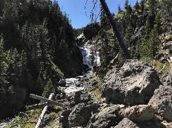
Mystic Falls
Old Faithful, Yellowstone National Park
32.0 miles EA lesser-known Yellowstone gem — a 70-foot cascading waterfall on Little Firehole River surrounded by quiet forest, with short and long viewing trails both described as easy.
Hike


