


7 Hiking Trails near Penryn Elementary School
first prev 1 next lastShowing Hiking Trails within 50 miles Distance miles of 6885 English Colony Way, Penryn, CA 95663, USA City, Zip, or Address

American River Confluence
Auburn, California
8.6 miles NEThe Confluence — where the North and Middle Forks of the American River meet below Foresthill Bridge — is Auburn's favorite swimming and rafting hub.
Hike, Horseback, Kayak, Rock Climb, Swim, Whitewater 1.2-2.7 mi
Lake Clementine Trail Loop
Auburn, California
8.7 miles NEFour connected trails loop around Lake Clementine on the North Fork American River — wheelchair accessible, pet friendly, and great for fishing, camping, and family summer outings.
Camp, Canoe, Hike, Kayak, Mountain Bike, Swim 5.6 mi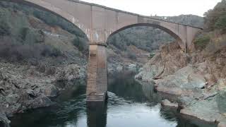
Quarry Trail
Cool, California
9.2 miles NEA riverside hike along an old limestone railway line to a dramatic amphitheater quarry — wildflowers peak April through June, and the historic railway story (scrap metal for WWII) adds a fascinating layer.
Hike 0.1 mi

Edwards Crossing
Nevada City, California
34.4 miles NDeep blue water, rock cliffs, and a sandy beach on the Yuba River — with a half-mile walk from the parking lot and cliff jumping spots up to 20 feet deep.
Hike, Swim
Sutter National Wildlife Refuge
Meridian, California
35.0 miles NWA 2,600-acre Sacramento Valley wildlife refuge 50 miles north of Sacramento, managing wetland impoundments and riparian habitat as critical wintering grounds for waterfowl.
Hike
North Fork Falls
Colfax, California
38.6 miles NEClear water, cliff-jumping pools, and waterfalls at Sierra Nevada's North Fork Falls — a summer hike to two deep pools with 10-to-25-foot cliffs ready for leaping.
Camp, Hike, Swim
Cosumnes River Preserve
Galt, California
43.1 miles SA 45,859-acre wildlife habitat and agricultural preserve centered on the Cosumnes River near Galt — supporting Pacific Flyway migrating birds and varied riparian habitats.
Canoe, Hike


