


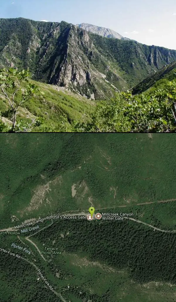
Mill Creek Canyon
Salt Lake City, Utah

Camp, Cross Country Ski, and Snowshoe
Mill Creek is an out and back with over 1000 ft of elevation gain. The lower section of the ski trail gets a lot of foot traffic, but the upper section (above Elbow Fork) is generally very quiet. At the top of the canyon, there is a Yurt than can be reserved from December to April. Mill Creek Canyon is managed by the U.S. Forest Service.
More Information
Add Resource- Plan Ahead and Prepare
- Travel & camp on durable surfaces
- Dispose of waste properly
- Leave what you find
- Minimize campfire impacts
- Respect wildlife
- Be considerate of other visitors
Directions
From Salt Lake City, Utah
- Head west on 400 S/University Blvd toward Main St (0.2 mi)
- Turn left at the 1st cross street onto W Temple (0.2 mi)
- Turn right onto 500 S/Cesar E. Chavez Blvd (0.6 mi)
- Take the I-80 E/I-80 W ramp on the left to Cheyenne/Reno/S.L. International Airport/Las Vegas (0.2 mi)
- Keep left at the fork, follow signs for I-15 S/I-80 E/Cheyenne/Las Vegas and merge onto I-15 S/I-80 E (2.5 mi)
- Keep right at the fork to continue on I-80 E, follow signs for Cheyenne/Interstate 80 (5.0 mi)
- Take exit 128 for Interstate 215 S/Belt Route (1.2 mi)
- Continue onto I-215 S/Belt Route (1.4 mi)
- Take exit 4 for 3900 S toward Hospital (0.2 mi)
- Turn left onto 3900 S (0.1 mi)
- Turn left onto Wasatch Blvd (0.1 mi)
- Turn right at the 1st cross street onto 3800 S/Millcreek Canyon RdContinue to follow Millcreek Canyon RdDestination will be on the right(4.7 mi)
Located at East on 3800 South (Mill Creek Canyon Road) from 3500 East (Wasatch Blvd.), Wasatch National Forest

Other Cross Country Ski Trails and Snowshoe Trails Nearby

Bells Canyon
Sandy, Utah
10.5 miles SWBells Canyon is a moderate, 4.5 mile hike that begins in a residential area and ends at a waterfall in the enter of the canyon's forest. The first 1/2 mile of the hike is relatively...
Backpack, Hike, Mountain Bike, Snowshoe
Mueller Park Trail
Bountiful, Utah
13.0 miles NWThe Mueller Park Trail is a great year-round trail that's almost right off the road. It's considered moderate difficulty. It's a gradual grade with beautiful views. It's a popular...
Cross-country Ski, Hike, Mountain Bike
Holbrook Trailhead
Bountiful, Utah
14.3 miles NWairsoft feaild woth bunkers
Airsoft, Backpack, Camp, Paintball, Snowshoe 1.2 mi
Ghost Falls Trail
Sandy, Utah
15.2 miles SGhost Falls is located in the corner canyon riding area of Draper, Utah and one of the first mountain bike routes in the canyon. It's a family-friendly hike, named for the...
Hike, Mountain Bike, Snowshoe 16.6 mi
Antelope Island Figure 8
Layton, Utah
31.6 miles NWThe vistas are awesome, the rock formations are beautiful, and the silence is something you don\\'t experience much these days. You WILL feel like you are on another planet when you are in the...
Hike, Mountain Bike, Snowshoe 7.2 mi
White Rock Loop
Syracuse, Utah
36.0 miles NWLocated on Antelope Island near Syracuse, Utah, the White Rock Loop is an easy trail perfect for viewing the magnificent landscape views while hiking or biking around. Dogs which are kept on leashes...
Hike, Mountain Bike, SnowshoeNearby Campsites

Spruces Campground
Salt Lake City, Utah
5.6 miles SECamping isn't free. See USDA.gov for details. If you know the coordinates of the sledding hill here, please comment.
Camp, Sled
Holbrook Trailhead
Bountiful, Utah
14.3 miles NWairsoft feaild woth bunkers
Airsoft, Backpack, Camp, Paintball, Snowshoe 1.6-14.1 mi
Mount Timpanogas
Provo, Utah
19.0 miles SMt. Timp, as the locals call it, is the 2nd highest mountain in the Wasatch range (only Mt. Nebo is higher). What sets "Timp" apart is its location. It towers over the Provo, Orem, Pleasant...
Camp, Hike, Horseback, Swim
Y-Mountain Summit Trail
Provo, Utah
31.9 miles SY Mountain is located directly east of Brigham Young University (BYU) in Provo, Utah, United States. The Slide Canyon/Y Mountain Trail leads to a large block Y located 1.2 miles (1.9 km) from a...
Camp, Hike 5.6 mi
Antelope Island Lakeside Trail
Syracuse, Utah
35.3 miles NWThe Lakeside Trail is a kid-friendly trail with great views and many bugs. This is a gorgeous scenic hike winding around part of the Great Salt Lake. The trail on Antelope Island that runs about...
Camp, Hike, Horseback
Antelope Island State Park
Syracuse, Utah
35.6 miles NWLocated just 41 miles north of Salt Lake City, Antelope Island State Park encompasses a vast selection of outdoor activities and spectacular scenery providing a peaceful nature experience. Experience...
Backpack, Camp, Hike, Horseback, Mountain Bike 2.9 mi
Pineview Reservoir
Eden, Utah
41.6 miles NLocated on the backside of the Wasatch Front, Pineview Reservoir in the Ogden River Canyon is home to stunning views of the water, sandy beaches, the Southern Skyline trail, paved ramps, and...
Camp, Canoe, Hike, Kayak, Mountain Bike, Swim
Hell Hole Lake
Evanston, Utah
46.0 miles EThe first 250 feet of this trail are on private property with access provided by Kayenta. The trail is actually the northern portion of Dry Wash. Sand and boulders litter the wash making hiking...
Camp, Hike, Horseback 4.7 mi
Fifth Water Hot Springs
Provo, Utah
46.6 miles SEAKA Diamond Fork Hot Springs A beautiful drive and a 2.5 mile hike along the river will end you at an amazing set of hot springs that's well worth the trip. There's a variety of...
Backpack, Camp, Hike, Hot Springs, Mountain Bike, Swim


