


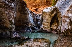
The Subway
Apple Valley, Utah
| Address: | Hurricane, UT 84737, USA |
| GPS: |
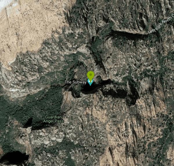
37°18'33.5"N 113°3'7.9"W Maps | Directions |
| State: | Utah |
| Trail Type: | Point A to B |
| Hike Difficulty: | Intermediate |
| Trails/Routes: | 7.5 mi |
Rivers Waterfalls Streams Trails Rocks Ponds National Park
Canyoneer, Hike, and Swim
The Subway is one of the best kept secrets of Zion National Park. A little off the beaten path, but a hike that is a must see for any adventure seeking person out there. Hikers begin at the Wildcat trailhead and descend in to the slot canyon that is about 3 miles long.
Once in the slot canyon hikers are in and out of the Virgin river that cuts through this majestic landscape as you hike, swim, rappel, and climb through the subway. With majestic tunnels and lava tubes it is easy to see why this slot canyon was nicknamed the Subway. In one area of the hike it is not required to rappel down the wall but it may be safer and it adds to the sense of adventure this hike brings. Be sure to bring lots of fresh water as some of the water in the hike is stagnant and not safe for human consumption.
Hikers may start at either the Wildcat Canyon Trailhead or the Left Fork Creek trailhead. Although, it is recommended by Zion National park to start at Wildcat Canyon as it is a more natural decent into the slot canyon and the difficulty increases having to climb out of the slot canyon and having to avoid hikers coming down, instead of descending into the slot canyon.
During points of the hike, hikers are required to wade through the deep waters that fill the slot canyon. There are a couple points where hikers can swim through small lava tubes that come out the other side of the cliff wall. As you near the end of the slot canyon, the water is much more free flowing and cascades down the red rock adding to the natural beauty and wonder of the landscape.
A permit must be secured in order to hike the Subway. Permits must be purchased at least 3 months in advance. The price of a permit depends on the amount of hikers in your group. If there are 1-2 hikers in your group, the cost is $15, for groups of 3-7, the price is $20,and for groups of 8-12 the price is $25. Permits must be picked up in advance of your trip at a ZNP Visitor's Center. As you exit the Subway, exit on the Left Fork North Creek trail and as you reach the top a shuttle will be there to take you back to your car at the Wildcat Canyon trailhead.
This hike is definitely off the beaten path in Zion National Park but it is absolutely worth the long hike in and out of the slot canyon to see the breathtaking views only the Subway offers. Tourists come from all over the world to see Zion National park but mainly stick to the attractions offered within the main park. Come explore a natural wonder in one of the most unique parts of the world that few have seen with their own eyes!
More Information
Zion National Park Itinerary
This Zion National Park Itinerary will help you get started as you plan your vacation to Zion National Park.
https://www.justgotravelstudios.com/collections/national-park-itineraries/products/zion-national-park-itinerary?ref=9zpxis0diinHiking Guide: The Subway From the Bottom
Overview There is no doubt that The Subway is one of Utah’s finest slot canyons and indeed word has gotten around. To help protect the canyon’s fragile riparian environment, Zion National Park only allows 60 people in per day. Jump to: How to Get a Subway Permit In my opinion, the best way to experience The Subway is from the top down. This route begins at Wildcat Trailhead, ends at Left Fork Trailhead and includes two rappels. However, if you don’t have the gear and/or technical expertise to go top down, then bottom up suffices. You will miss the Upper
https://backobeyond.blog/hiking-guide-the-subway-from-the-bottom/Left Fork (Subway) - Zion National Park (U.S. National Park Service)
Permit holders must arrange their own transportation to the Wildcat and/or Left Fork Trailhead to complete their route.
https://www.nps.gov/zion/planyourvisit/thesubway.htmSubway - Zion National Park - Canyoneering
The Subway of Zion National Park is a great Utah slot canyon. Information, Guide and pictures on the Subway.
https://www.climb-utah.com/Zion/subway.htmThe Subway Hiking Trail in Zion National Park | Utah.com
The Subway in Zion is a semi-technical hike slightly more intense than the Narrows. Ropes are helpful. Permits required.
https://www.utah.com/destinations/national-parks/zion-national-park/places-to-see/the-subway/Be courteous, informed, and prepared. Read trailhead guidelines, stay on the trail, and don't feed the wildlife.
Read More- Plan Ahead and Prepare
- Travel & camp on durable surfaces
- Dispose of waste properly
- Leave what you find
- Minimize campfire impacts
- Respect wildlife
- Be considerate of other visitors
Directions
From Apple Valley, Utah
- Head west on Rome Way toward N Apple Valley Dr (371 ft)
- Turn left onto N Apple Valley Dr (0.2 mi)
- Turn right to stay on N Apple Valley Dr (0.1 mi)
- Turn right onto UT-59 N/
State St Continue to follow UT-59 N(8.5 mi) - Turn right onto Sheep Bridge Rd (4.9 mi)
- Turn right onto UT-9 E (1.4 mi)
- Turn left onto Pocketville Rd (0.8 mi)
- Turn left onto Kolob Terrace Rd (12.5 mi)
- Turn right (3.0 mi)


Other Swimming Holes, Hiking Trails, and Canyons Nearby

Riverside Walk
Springdale, Utah
5.9 miles EA flat, paved riverside walk through Zion's desert swamp oasis, with hanging gardens on the cliffs and the option to continue into The Narrows — check flood conditions first.
Hike 2.6 mi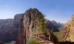
Angels Landing
Springdale, Utah
6.5 miles SEZion's most iconic strenuous day hike — 21 steep switchbacks, dramatic Scout Lookout views, and a narrow chain-assisted ridge with 1,000-foot drop-offs to an unmatched canyon summit.
Hike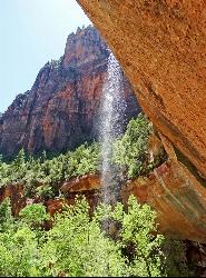
Emerald Pools Trail
Hurricane, Utah
6.5 miles SEThree algae-tinted pools carved into Zion's canyon walls glow with an otherworldly emerald color fed by near-constant waterfalls — though swimming and wading are strictly prohibited.
Hike
The Grotto Trail
Springdale, Utah
6.6 miles SEThe Grotto Trail is an easy, nearly level half-mile Zion walk linking Zion Lodge and The Grotto — and the gateway to Angels Landing.
Hike 3.3 mi
Guacamole Mesa
Virgin, Utah
6.6 miles SWAn 11-mile advanced desert loop on Guacamole Mesa outside Zion NP — a steep, narrow climb with gorgeous red rock views gives way to a flat desert finish; avoid in rain.
Hike, Mountain Bike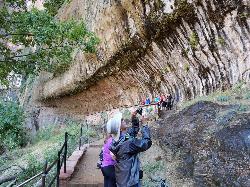
Weeping Rock
Springdale, Utah
6.8 miles SEA short but steep 0.4-mile hike in Zion to a natural alcove where water seeps through sandstone, feeding lush hanging gardens of maidenhair ferns — with views of the Great White Throne.
Hike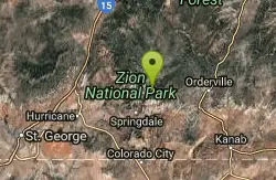
Echo Canyon
Springdale, Utah
7.5 miles EA technical canyoneering route through Zion's Echo Canyon with eight miles of trail, 2,148 feet of elevation to Observation Point, and a short detour to the 'weeping' Weeping Rock formation.
Canyoneer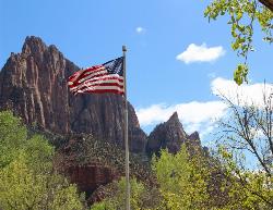
Zion National Park
Hurricane, Utah
8.1 miles SEWind, water, and ice sculpted Zion's iconic red sandstone buttes, bends, and mounts into one of the most breathtaking and irreplaceable landscapes on Earth.
Camp, Hike, Mountain Bike, Swim 5.2 mi
Mystery Canyon
East Gate Zion National Park, Utah
8.4 miles EOne of the most unique canyoneering routes in the US — rappel through Zion's narrows, down sheer cliffs, and finish with a final drop into the Virgin River as shuttles pass below.
Canyoneer
Pine Creek Canyon
Hurricane, Utah
9.1 miles SEA popular technical canyoneering adventure near Hurricane that takes roughly four hours to complete through heavily traveled Pine Creek Canyon.
Canyoneer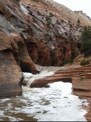
Keyhole Canyon
Springdale, Utah
10.1 miles SEOne of Zion's most accessible slot canyons, Keyhole Canyon begins just 300 feet from the highway and features three sections of narrows with sheer drops requiring ropes.
Canyoneer 11.6 mi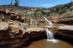
Toquerville Falls
La Verkin, Utah
10.7 miles WLedges, falls, a ladder to the best jumping spots, and a 7-foot-deep pool at the end of a 5.5-mile sandy desert drive — but stay away from the brittle, injury-prone cliff edges.
Dive, Hike, Mountain Bike, Swim 7.0 mi
J.E.M. Trail
La Verkin, Utah
11.8 miles SWA 13.27-mile round-trip mountain bike trail near Hurricane, Utah with jarring terrain and sharp turns near sheer cliffs — beautiful red rock and desert views reward the effort.
Hike, Mountain Bike 5.1 mi
Dead Ringer
Virgin, Utah
15.8 miles SWA 5-mile desert singletrack starting from the JEM trailhead near Virgin, winding through ups and downs and bottoming out in the bumpy, hoof-print-marked Goosebumps area.
Hike, Mountain Bike 3.4 mi
More Cowbell
Virgin, Utah
15.8 miles SWA smooth 2.7-mile beginner mountain bike loop through red Utah desert bluffs — mostly flat singletrack that's also great for hikers and connects to more challenging trails.
Hike, Mountain Bike 3.6 mi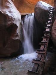
Kanarraville Falls
Kanarraville, Utah
17.1 miles NWA slot canyon hike through ankle-to-knee-deep water to twin waterfalls, with a natural sandstone slide into a refreshing swimming hole halfway through the route.
Hike, Swim 0.7 mi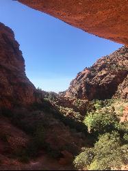
Red Reef trail
Hurricane, Utah
20.3 miles WTwo miles of red slickrock, a slot canyon, a spring waterfall, and ancient Anasazi hieroglyphs in a small cave make this an exceptional family-friendly desert hike.
Hike 1.1 mi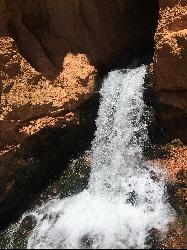
Cascade Falls
Cedar City, Utah
20.9 miles NEA 1.2-mile family-friendly round-trip hike through sandstone stairs and red-cliff scenery to a waterfall fed by underground tubes from Navajo Lake — with sweeping views of Cedar Valley and Zion.
Hike
Sand Hollow State Park
Hurricane, Utah
22.4 miles SWA desert reservoir near Hurricane with a cliff-jumping area, a sandy beach for swimming and paddleboarding, and vast sand dunes for ATVs — southern Utah's desert playground.
Camp, Canoe, Dive, Kayak, Swim 9.4 mi
Church Rocks
Washington, Utah
26.4 miles SWA nearly 6-mile red rock ride near St. George winding through sandy desert washes and smooth slick rock — a great practice run before tackling Moab's Slick Rock Trail.
Hike, Mountain BikeNearby Campsites
Zion National Park
Hurricane, Utah
8.1 miles SEWind, water, and ice sculpted Zion's iconic red sandstone buttes, bends, and mounts into one of the most breathtaking and irreplaceable landscapes on Earth.
Camp, Hike, Mountain Bike, Swim
Sand Hollow State Park
Hurricane, Utah
22.4 miles SWA desert reservoir near Hurricane with a cliff-jumping area, a sandy beach for swimming and paddleboarding, and vast sand dunes for ATVs — southern Utah's desert playground.
Camp, Canoe, Dive, Kayak, Swim
Dixie National Forest
Cedar City, Utah
32.1 miles NEOver 2 million acres of red rock canyons, forests, Duck Creek, and a ski resort span Dixie National Forest — with elevations from 2,800 to 11,322 feet and year-round recreation including skiing, snowmobiling, and hiking.
Backpack, Camp, Hike


