


Cascade Falls
Cedar City, Utah
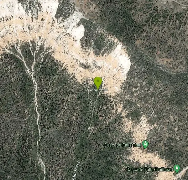
| Address: | Cascade Falls, Utah 84762, USA |
| GPS: |
37°30'6.9"N 112°45'25.8"W Maps | Directions |
| State: | Utah |
| Trails/Routes: | 1.1 mi |
Hike
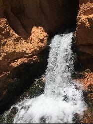
Cascade Falls, located outside of Cedar City, Utah, is a beautiful waterfall that is just a 1.2 mile hike round trip, ending at Cascade Falls. It is somewhat of a hidden local hotspot that not many outside of the area know much about it. The hike itself is very family friendly in that small children can likely make the hike, keeping both parents and children happy. There are several landmarks to take note of as you hike the Cascade Falls trail. One landmark is the stairs that were meticulously plotted along the trail which add both an element of comfort and beauty to the hike as they match the sandstone landscape. Another landmark to look out for is the upper Cascade Falls viewpoint where hikers are allowed to get an up close view of these beautiful falls.
The water from the waterfall derives from the Navajo Lake that then funnels into a series of sinkholes in the area. This water is special because before it reaches the falls, it travels through many underground water tubes. The falls can be seen multiple times throughout the hike. When you approach it in the end, you won't be able to swim or go in, but you can definitely take advantage of the views!
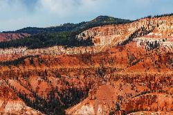
Although the hike is short, it is fairly steep in parts, so be prepared with water and some snacks as you hike in the area. Located in the red cliffs just outside of Cedar City, visitors have a great view of the Cedar Valley and Zion National Park. The best times to hike the Cascade Falls trail is from June to September to avoid runoff from snow melts and icy trail conditions. If desired, hikers have the option of hiking up to Navajo Lake which feeds the beautiful Cascade Falls.
There are benches along the hike to ease the hikers on their journey as well as encourage the hiker to enjoy the magnificent views through the canyon. The trail is very well maintained, and remains about the same in elevation until you get to the final few yards, then the elevation kicks in a little bit.There is hardly any shade on the hike, so be sure to bring sunscreen, water, and a hat to protect your skin from sunburn. To beat the sun, you could complete this hike in the morning or the evening. This hike is superbly short, making it great for families and busy people who still want to get their fill of nature while accomplishing other task for the day.
This hike is proof that Cedar City and Cedar Breaks National Forest are no mere stopping point on the way to St. George. Cascade Falls will take your breath away making you wanting to come back for more!
More Information
Be courteous, informed, and prepared. Read trailhead guidelines, stay on the trail, and don't feed the wildlife.
Read More- Plan Ahead and Prepare
- Travel & camp on durable surfaces
- Dispose of waste properly
- Leave what you find
- Minimize campfire impacts
- Respect wildlife
- Be considerate of other visitors
Directions
From Cedar City, Utah
- Head west toward W Harding Ave (226 ft)
- Turn right onto W Harding Ave (190 ft)
- Turn right after Wells Fargo Bank (on the right) (436 ft)
- Turn left onto UT-14 E/
E Center St Continue to follow UT-14 E(25.3 mi) - Turn right onto FR053/
Navajo Lake Rd (0.3 mi) - Turn left onto Cascade Falls Rd/
FR370 Continue to follow FR370(0.5 mi) - Turn right onto FR678 (2.2 mi)
 Cascade Falls by Tyler Burgener


 View from Cascade Falls Trail courtesy of Ken Lund↗
 Tall pines along Cascade Trail courtesy of Ken Lund↗
 View along the Cascade Falls Trail by Tyler Burgener
 Cascade Falls trailhead by Tyler Burgener

 Another view along the Cascade Falls Trail by Tyler Burgener
 Family hiking Cascade Trail courtesy of Ken Lund↗
 View of Cascade Falls flowing down the mountain by Tyler Burgener
 Cedar Breaks National Forest along Cascade Falls Trail by Tyler Burgener
 Cascade Falls informational sign by Tyler Burgener

Added by torontoty1214
Trails
Distance ?
1.1 miles Round TripElevation Gain ?
-47 feetReal Ascent ?
147 feetReal Descent ?
194 feetAvg Grade (-1°)
-2%Grade (-36° to 32°)
-72% to 63%Elevation differences are scaled for emphasis. While the numbers are accurate, the cut-away shown here is not to scale.
Other Hiking Trails Nearby
Dixie National Forest
Cedar City, Utah
12.1 miles NDixie National Forest is an often forgotten/hidden gem in Cedar City. It is over 2 million acres of beautiful red rock canyons and trees. Dixie Forest isn't only limited to rocks and...
Backpack, Camp, Hike
Riverside Walk
Springdale, Utah
17.9 miles SWThe Virgin River has many moods, from quiet and slow to a raging torrent. This beautiful, shaded walk meanders through forested glens, following the path of the stream ever deeper into the...
Hike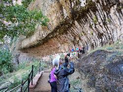
Weeping Rock
Springdale, Utah
18.8 miles SWExpect to get wet on this short hike! Weeping Rock gets its name from the continuous "weeping" of water that seeps through sandstone and drips from the cliffs above. Seasonal flowers...
Hike 2.6 mi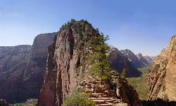
Angels Landing
Springdale, Utah
19.9 miles SWAngels Landing is one of the park's most strenuous day hikes, but it offers spectacular vistas. It follows the West Rim Trail through the famous switchbacks of Walters Wiggles, past dramatic...
Hike
The Grotto Trail
Springdale, Utah
20.0 miles SWThe Grotto Trail is a short easy trail that connects The Grotto shuttle stop and Zion Lodge. It follows near the road for about 1.5 miles and has an elevation gain of about 130 feet.
Hike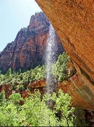
Emerald Pools Trail
Hurricane, Utah
20.6 miles SWThe Emerald Pools were named for their unusual color. At some times of the year, algae gives the water in these pools a distinctive hue. A series of basins have been carved into a rock ledge in the...
Hike 7.5 mi
The Subway
Apple Valley, Utah
21.0 miles SWThe Subway is one of the best kept secrets of Zion National Park. A little off the beaten path, but a hike that is a must see for any adventure seeking person out there. Hikers begin at the Wildcat...
Canyoneer, Hike, Swim 3.6 mi
Kanarraville Falls
Kanarraville, Utah
23.1 miles WKanarraville falls (also known as Kanarra falls) located outside of Cedar City, Utah is a must-see stop for any adventurous souls. Kanarra Falls is a medium length hike, both on trail and through...
Hike, Swim
Zion National Park
Hurricane, Utah
24.0 miles SWThis is a unique place in the world. Sandstone,carved from wind, water and ice have created icons to visitors. The buttes, landings, bends, mounts and mountains have all been given names over the...
Camp, Hike, Mountain Bike, Swim 7.4 mi
Red Slot Canyon AKA Peek-a-boo
Kanab, Utah
26.0 miles SThis great little slot canyon is officially Red Slot Canyon but is also referred to as Peekaboo Canyon. It is not to be confused with Peek-a-boo Canyon near Spooky Gulch. It's not really very...
Hike 3.3 mi
Guacamole Mesa
Virgin, Utah
27.3 miles SWGuacamole Mesa, also known by locals as the Whole Guacamole, is an advanced level biking trail in Virgin, Utah (just outside of Hurricane). The trail starts in a climb up the mesa that features tight...
Hike, Mountain Bike 8.1 mi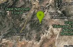
Riggs Spring Loop Trail
Kanab, Utah
28.4 miles ERiggs Spring Loop Trail is the perfect trail for hikers wishing to escape to the wilderness. This is one of the least trafficked trails in Bryce Canyon and one of the most forested. The ponderosa...
Hike 1.0 mi
Bristlecone Loop
Kanab, Utah
28.5 miles EBristlecone Loop is a one-mile trail from Rainbow Point. Rainbow Point is located at the southern end of Bryce Canyon National Park and is the highest point in the park. The spectacular views...
Hike 0.8 mi
Moqui Caverns
Kanab, Utah
28.8 miles SLocated near the small town of Kanab, Utah, The Moqui Caverns are a rare sight to behold. With bright flourescent rocks, Moqui Caverns is one of the more unique hikes not only in the state of Utah,...
Cave, Hike
Montezuma Mines
Kanab, Utah
30.1 miles SEA bunch of sand caves/mines. There are some pits with old ladders, and at least one pit in particular that you can descend with a rope.
Cave, Hike 4.1 mi
Swamp Canyon Overlook and Trail
Bryce, Utah
30.3 miles ESwamp Canyon Trail is a wonderful, lesser-explored trail of moderate difficulty. Hikers in this area can expect to see some of Bryce Canyon’s famous rock formations, while also experiencing the...
Hike 11.6 mi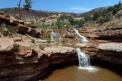
Toquerville Falls
La Verkin, Utah
30.4 miles SWNothing says desert oasis quite like driving for 5.5 miles through winding sandy roads to find a favorite swimming hole with ledges, falls, and even a ladder to climb up to the best jumping spots....
Dive, Hike, Mountain Bike, Swim 6.9 mi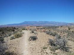
J.E.M. Trail
La Verkin, Utah
32.8 miles SWThe J.E.M. trail is one of the many exciting trails located just outside of Hurricane, Utah. It is connected with the More Cowbell and Dead Ringer trails and is the longest of all three trails...
Hike, Mountain Bike 1.2 mi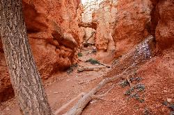
Navajo Trail
Bryce, Utah
33.4 miles ENavajo Trail explores the main amphitheater of Bryce Canyon National park in a short but winding hike. The hike begins at Sunset Point and splits off into a loop. The loop can be taken in either...
Hike 1.8 mi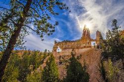
Tower Bridge
Bryce, Utah
33.4 miles ETower Bridge is a unique and uncrowded trail in Bryce Canyon. Tower Bridge gets its name from the prominent rock formation the trail leads to. The rock formation resembles London Bridge and is a...
HikeNearby Campsites
Dixie National Forest
Cedar City, Utah
12.1 miles NDixie National Forest is an often forgotten/hidden gem in Cedar City. It is over 2 million acres of beautiful red rock canyons and trees. Dixie Forest isn't only limited to rocks and...
Backpack, Camp, Hike
Zion National Park
Hurricane, Utah
24.0 miles SWThis is a unique place in the world. Sandstone,carved from wind, water and ice have created icons to visitors. The buttes, landings, bends, mounts and mountains have all been given names over the...
Camp, Hike, Mountain Bike, Swim
Sunset Campground
Bryce, Utah
33.0 miles ESunset Campground is one of Bryce Canyon's two main campgrounds. It consists of 101 campsites linked together with three loops, loops A B and C. There are 20 tent-only campsites, 80 tent and RV...
Camp
North Campground
Bryce, Utah
33.6 miles ENorth Campground is one of the two main campgrounds in Bryce Canyon National Park. The campground is open to RV and tent campers. Thirteen RV sites available for reservation and 86 RV and tent sites...
Camp
Sand Hollow State Park
Hurricane, Utah
43.4 miles SWSand Hollow is the closest thing to a tropical paradise in the middle of the Utah desert, near Hurricane, Utah. It features a beach area, places to cliff jump, swim, and off-road with your ATV. There...
Camp, Canoe, Dive, Kayak, Swim


