


214 Things to do near Big Bend Ridge Trail
first prev 1 2 3 4 5 6 7 8 9 10 next lastShowing results within 50 miles Distance miles of Forest Road 343, Ashton, ID 83420, USA City, Zip, or Address

Ashton Hill
Ashton, Idaho
5.1 miles SEFairly thick forest. Considerable underbrush. Lots of places in the area to play.
Airsoft, Paintball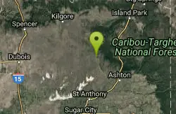
Sand Creek Frenzy
Ashton, Idaho
5.5 miles WThere are some woods back there and it is secluded. There are many places you can play just watch out for campers.
Paintball
Sheep Falls on Henry's Fork
Island Park, Idaho
6.3 miles ESheep Falls cascades approximately 25' through a narrow basalt chute on the North Fork of the Snake River near Island Park, Idaho. Compared to nearby Lower and Upper Mesa Falls, that height may...
Hike 0.6-4.7 mi
Harriman State Park
Island Park, Idaho
7.2 miles NEHarriman State Park is found 38 miles from Yellowstone along Henry's Fork. This 11,000-acre wildlife refuge is open year round for most activities. In addition to having beautiful scenery and...
Cross-country Ski, Hike, Horseback, Mountain Bike, Snowshoe
Mesa Falls
Ashton, Idaho
9.9 miles EUpper Mesa Falls, aka Big Falls, is an absolutely awesome waterfall on the Henrys Fork of the Snake River. The falls drop 114 ft. and measure 300 ft. across. To get to the falls from the parking lot...
Cross-country Ski, Hike, Kayak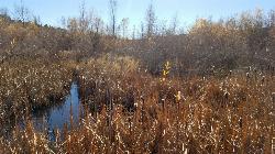
River Rush
Ashton, Idaho
10.9 miles SPaintball near Ashton, Idaho
Paintball 29.6 mi
Ashton to Tetonia Trail
Ashton, Idaho
11.3 miles SThe Idaho Department of Parks and Recreation undertook the project to transform the old Teton Valley Branch of the Union Pacific Railroad from Ashton to Tetonia into a trail for bikes, ATVs, and...
Mountain Bike
The Pit
Ashton, Idaho
12.7 miles SEThis location is great because there is no one around only locals know of this area and you can shoot anything out there. Watch out for target shooters there! Also stay away from the main road.
Airsoft, Paintball 3.2-47.0 mi
Yellowstone Branch Line Trail
Ashton, Idaho
12.7 miles SEYellowstone branch line trail runs from Warm River to the Montana border totaling 39 miles. There are a few places to jump on and off the trail as well as a few smaller trails that branch off of this...
Backpack, Cross-country Ski, Hike, Horseback, Mountain Bike 0.3-0.6 mi
Bear Gulch
Ashton, Idaho
12.7 miles SEBear Gulch is an abandoned ski hill out of operation since 1969. While the vegetation is beginning to take over, there's still some great sledding to be had. It's just far enough into the...
Camp, Cross-country Ski, Hike, Sled
Warm River Campground
Ashton, Idaho
12.8 miles SEWarm River Campground is located nine miles northeast of Ashton, Idaho, along the slow-moving Warm River at an elevation of 5,200 feet. Willows line the riverbanks and pine trees offer partial...
Camp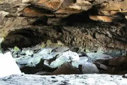
Civil Defense Caves
Rexburg, Idaho
13.6 miles WThe caves are large lava tubes. The name comes from the cold war era when they were anticipated as a safe area in the case of an attack. The entrance is pretty bouldery and does require a small...
Cave
Flat Canyon Trail
Island Park, Idaho
14.2 miles ENon-motorized use. souce: fs.usda.gov
Mountain Bike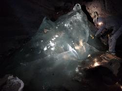
Rexburg Area Ice Caves
Rexburg, Idaho
14.3 miles WNot to be mistaken with the Civil Defense Caves (which are near by), the Ice Caves are about an hour North outside of Rexburg. The Ice Caves were originally formed as lava tubes. The shape of the...
Cave 5.8 mi
Box Canyon Trail
Island Park, Idaho
14.4 miles NEVarious species of tress and wildflowers can be seen on the trail, as well as songbirds, waterfowl and occasional wildlife. The trail is open for the following uses: Motorcycle Trail Riding, Off...
Hike, Mountain Bike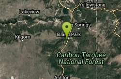
Box Canyon Island Park
Island Park, Idaho
14.4 miles NEThe Box Canyon Campground is situated on the canyon rim above the Henry's Fork of the Snake River. There are 16 single and 2 double units, each having tent and camper pads, fire rings, grills...
Canoe
Twin Bridges
St. Anthony, Idaho
14.7 miles SThere's an old abandoned bridge next to the one currently in use. The water is pretty deep underneath and offers two distinct levels to jump from. There's a little rope swing under the bridge...
Dive, Swim
Pine Butte / The Caldera
St. Anthony, Idaho
15.2 miles WThis is about as close to an oasis as you can get in the deserts of Idaho. It's an old volcano in the middle of the sagebrush desert. As soon as you start down the path, you can feel the air...
Camp, Hike, Horseback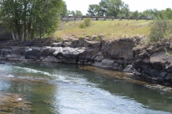
Fall River Bridge
Ashton, Idaho
15.3 miles SRight off Highway 20, there's a great spot to swim, swing, and dive. There's pullouts for parking right next to the bridge. There's a rope swing under the railroad bridge and a little...
Dive, Swim 0.8 mi

Conant Creek Pegram Truss Railroad Bridge
Ashton, Idaho
15.8 miles SEAs part of the Rails to Trails project, this old railroad bridge has been transformed into a very safe little viewing experience for the whole family. You can drive right up to the bridge where there...
Hike


