


198 Things to do near Leigh Lake
first prev 1 2 3 4 5 6 7 8 9 10 next lastShowing results within 50 miles Distance miles of String Lake Trail, Alta, WY 83414, USA City, Zip, or Address

Sheep Falls on Henry's Fork
Island Park, Idaho
43.7 miles NWSheep Falls cascades approximately 25' through a narrow basalt chute on the North Fork of the Snake River near Island Park, Idaho. Compared to nearby Lower and Upper Mesa Falls, that height may...
Hike 2.6 mi
Lone Star Geyser Trail
Old Faithful, Yellowstone National Park
43.7 miles NLone Geyser Star Trail is a hiking and mountain biking trail that leads through the forest to the colorful Lone Star Geyser. The Geyser here has beautiful white, yellow and orange colors in the...
Hike, Mountain Bike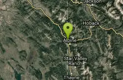
Alpine Campground
Alpine, Wyoming
43.8 miles SLocated two miles west of Alpine, Wyoming. Campground is situated in lodgepole pine trees, on flat terrain, and subject to wind and summer thunderstorms. Area is located near the south end of...
Camp 0.5-3.5 mi
Webster's Dam
Ririe, Idaho
43.8 miles WAlso known as Manmade Falls or the Woodmansee Dam, Webster Dam is an abandoned dam located deep in Moody Creek canyon, the dam was abandoned when sediment built up behind the dam which then...
Camp, Hike, Mountain Bike
Kelly Canyon Loops
Ririe, Idaho
43.9 miles WThis mountain bike trail near Kelly Canyon Ski Area has several options available. Highlights are the views in all directions from the top of the mountain. Trails: Waterfall...
Mountain Bike 4.3 mi
Leaning Fir #169
Ririe, Idaho
43.9 miles WMountain Bike near Ririe, Idaho
Mountain Bike 1.4 mi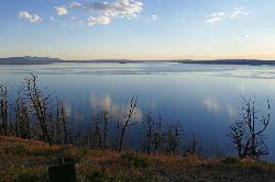
Yellowstone Lake Overlook Trail
Grant Village, Yellowstone National Park
44.0 miles NYellowstone Lake Overlook Trail is a 1.7 mile loop trail that is easy and great for beginner hikers. The trail begins near the West Thumb Geyser Basin Parking Lot and is open in the summer and fall.
Hike
Lake Overlook
Grant Village, Yellowstone National Park
44.0 miles NThis trail is located in the southern part of the park, with the trailhead in the West Thumb Geyser Basin parking lot. This is about a 1.7 mile hike, roundtrip, that starts and ends at the...
Hike 0.4 mi
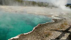
West Thumb Geyser Basin
Grant Visitor's Center, Yellowstone National Park
44.0 miles NWest Thumb Geyser Basin is one of the smaller geyser basins in Yellowstone, yet its location along the shore of Yellowstone Lake and is ranked as the most scenic. This area was formed by volcanic...
Hike 0.4 mi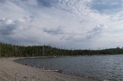
Duck Lake
Grant Village, Yellowstone National Park
44.1 miles NDuck Lake Trail is located near Grant Village and West Thumb. This is a simple 0.8 miles hike that takes you through the Lodgepole pine forest. This hike is special because the surrounding...
Hike 11.9 mi
Waterfall Loop
Ririe, Idaho
44.1 miles WTrail is a mixture of single track, forest road and double track. Provides a variety of scenery. About 1400 feet of elevation change throughout the trail.GPS is a must unless you are going with...
Mountain Bike
Bighole Mountains / Moody
Ririe, Idaho
44.2 miles WThis is a little unofficial campground with a plenty of shade for your basecamp and a wooded field with great boundaries. There's 2 roads that split and merge giving you very simple...
Airsoft, Paintball
Lower Hawley Gulch Trail
Ririe, Idaho
44.3 miles WThis is a singletrack biking trail in Ririe, Idaho. The trail is mainly flat with a few gradual slopes. You may have to carry your bike over obstacles such as fallen trees, logs, and small ponds....
Mountain Bike
Table Rock Campground
Ririe, Idaho
44.3 miles WTable Rock / Poison Flat Campground is located at the Caribou-Targhee National Forest which occupies over 3 million acres and stretches across southeastern Idaho, from the Montana, Utah, and Wyoming...
Camp 1.1 mi
Hidden Vista / Pine Loop
Ririe, Idaho
44.4 miles WYou'll find the Hidden Vista trailhead on the South End of the Buckskin Morgan parking lot about a mile past Y Junction. This is a short trail with a little up and a little down for just under a...
Hike, Mountain Bike 5.7-8.1 mi
Space Cruz
Ririe, Idaho
44.4 miles WThe trail starts out with a really flowy singletrack then connects up to some ATV trails. On the single track, just stay on the main trail. There are several little splits several you can take...
Cross-country Ski, Mountain Bike 1.7 mi
Buckskin Morgan Ridge
Ririe, Idaho
44.4 miles WGoing up is a little tough because of the rocks, but once you clear the top it is a twisty down hill portion [until] you get to a fenced road. From there you can turn around or keep going strait...
Hike, Mountain Bike
Kelly Canyon/Table Rock
Ririe, Idaho
44.4 miles WThe initial climb is soft, so you might wash out a little. There are enough roots and rocks to add some challenge to the climb and some air to the descent. The trail forks at one point,...
Mountain Bike
Big Hole Dispersed Campsites
Ririe, Idaho
44.5 miles WA dispersed campsite is simply an unestablished and unmaintained area where people camp. Often, this means that there is a campfire or other basic campsite feature to identify the site and that's...
Camp
Poison Flats
Ririe, Idaho
44.6 miles WHike near Ririe, Idaho
Hike


