


2.0K Bucket List by camilledupar
first prev 1 2 next last
Sheep Falls on Henry's Fork
Island Park, Idaho
15.6 miles S of Island Park, IdahoSheep Falls is a beautiful, lesser-known waterfall on the Henry's Fork of the Snake River near Island Park, Idaho, where the river squeezes through a narrow basalt chute and drops about 25 feet in a churn of whitewater. It may be shorter than the famous Upper and Lower Mesa Falls just across the way, but it's every bit as scenic — and far quieter, making it a wonderful reward for a short, easy hike.
The trail to Sheep Falls is a gentle stroll of roughly a mile each way on a relatively well-maintained path, suitable for the whole family and rarely crowded. The route sits on the opposite side of the river from Mesa Falls, off Highway 20: head north past Ashton, turn onto Sheep Falls Road, and follow it to the trailhead — though be warned, the final dirt road is rough and rocky, so a high-clearance vehicle is a good idea.
There are calmer pockets near the falls where people wade and swim on hot summer days, but the water here deserves real respect. The current above and around the chute is powerful and can sweep you off your feet and pull you toward the drop. Stay well back from the lip, keep a close eye on children, and only consider getting in where the water is clearly calm and you know it's safe — when in doubt, enjoy the falls from the bank.
The best season runs roughly May through October, when the road is passable and the river is at its most beautiful. Bring sturdy shoes, water, and a camera, pack out everything you bring in, and you'll discover one of the Island Park area's most underrated natural treasures.

Mr. Bubbles Hot Spring
Old Faithful, Yellowstone National Park
24.0 miles SW of Old Faithful, Yellowstone National ParkMr. Bubbles is one of the very few places in Yellowstone National Park where you can legally and safely soak in naturally heated water — a rare treat in a park where hot springs are usually deadly rather than inviting. It sits deep in the Bechler region in Yellowstone's remote southwest corner, an area known as “Cascade Corner” and one of the park's best-kept secrets: far from the paved roads, boardwalks, tour buses, and gift shops, reached only by miles of backcountry trail.
The soak itself is a natural mixing pool. A hot spring wells up into the cold Ferris Fork of the Bechler River, and where the scalding spring water blends with the cold river it reaches a blissfully soakable temperature — while gas bubbling up from below gives the spot its playful name. That mixing is also the key to why soaking here is allowed: getting into Yellowstone's thermal features is strictly forbidden, but the Park Service permits soaking where hot water has already blended with a river or stream. Enjoy the warm water where it mixes, and stay well clear of the undiluted hot source.
You'll find it roughly halfway between the Bechler Ranger Station and Old Faithful along the Bechler River Trail. This is genuine backcountry — most visitors reach it on a multi-day backpacking trip, walking singletrack dirt trails past waterfalls and meadows and seeing wildlife well outside the safety of a car. Be bear-aware and give bears, moose, and bison plenty of space. To camp along the way you'll need a backcountry permit, reserved through the park's backcountry office.
The journey is a huge part of the reward. The Bechler is nicknamed Cascade Corner because it holds more waterfalls than anywhere else in Yellowstone — the trail near Mr. Bubbles strings together beauties like Colonnade, Iris, and Ouzel Falls, and nearby Union Falls is one of the park's most spectacular. For backpackers, a soak at Mr. Bubbles makes the perfect midpoint of a waterfall-studded wilderness traverse.
A few life-or-death cautions. Thermal water temperatures here change without warning and are not always safe — the National Park Service advises checking with a ranger station on current conditions before you plan a trip. And never hike through Yellowstone's thermal areas at night: even experienced hikers have broken through thin crust and been scalded to death in unexpected hot ground. Always review the park's swimming-and-soaking guidance for current closures, regulations, and conditions before you go.
Timing matters in the Bechler. It's the wettest corner of Yellowstone, with numerous river fords that run dangerously high during spring and early-summer snowmelt, so the backcountry here is generally best from late summer into early fall, once the water drops. Come prepared for remoteness, river crossings, mosquitoes, and sudden mountain weather — and you'll be rewarded with a genuinely wild Yellowstone soak that few visitors ever experience.

Ashton to Tetonia Trail
Ashton, Idaho
0.7 miles NE of Ashton, IdahoThe Idaho Department of Parks and Recreation undertook the project to transform the old Teton Valley Branch of the Union Pacific Railroad from Ashton to Tetonia into a trail for bikes, ATVs, and snowmobiles, runners, cross-country skiers, and horses. The trail goes from Ashton to Tetonia and can be accessed via Ashton, Marysville, Bitch Creek, Felt, or Tetonia. Information can be found at kiosks in Marysville and at Bitch Creek.
Elevation Gain (Southbound): 787 ft
Length: 29.6 mi
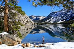
Tenaya Lake
Yosemite Valley, Yosemite National Park
9.3 miles NE of Yosemite Valley, Yosemite National ParkTenaya Lake is one of the most visited destinations in Yosemite National Park. The lake is easily accessed by Highway 120/Tioga Pass road which runs along the north shore of the lake. On the east shore of the lake is a very large beach where most people will enter the lake to go swimming, canoeing, and kayaking. The road to the lake normally opens up in May, though depending on snow it might be later, and stays open until October.
This lake is surrounded by beautiful scenery and hiking trails. One of the most popular trails for visitors to take is the Cloud Rest/Sunrise Lakes trail because it offers the best views of the lake and adjacent mountains. Like all of Yosemite, the area surrounding Tenaya lake was formed by glaciers and includes some beautiful granite peaks and domes. From the west end, visitors will be able to see Polly Dome, Pywiack Dome, and Mount Conness.
When the road to the lake is open, many people enjoy driving up and enjoying all of the hiking and views nearby. The mountains and peaks nearby offer plenty of hiking and climbing trails for all abilities.

Mirror Lake
Yosemite Valley, Yosemite National Park
2.4 miles E of Yosemite Valley, Yosemite National ParkMirror Lake is a seasonal lake situated in a secluded corner of the beautiful Yosemite Valley. The lake sits at the base of Half Dome and allows a different perspective of the famous monolith. Hikers will also have the chance to see the Tenaya Canyon, Mount Watkins, and Washington Column. Because the lake is seasonal, the best time to visit is in the spring or early summer, when all the snowmelt is running through the area. When the water is calm, hikers will be able to understand why the lake is called Mirror Lake: the still reflection shows the surrounding cliff faces and the crown of Half Dome. If visiting in the late summer, fall, or winter, Mirror Lake becomes Mirror Meadow, filled with grasses and other plant life as well as snow.
The trail is a very easy trail and can be done with the whole family. It is 2 miles round trip to the lake and back, but can be up to 5 miles round trip if taking the loop around the lake. The shorter trail to the lake can be completed in about an hour, and 2-3 hours if doing the full loop. The trail is paved and open only to hikers or biking. Cars are not allowed on the trail, however there are numerous shuttles in the Yosemite Valley that can take hikers to the trailhead.
In the summer the lake becomes a very popular swimming hole, and attracts a lot of visitors. Another attraction to the lake is a small area where previous visitors have left cairns (stacks of rocks usually designating a trail). This "cairn garden" seems to grow with more and more cairns added each year. There is a wide variety from tall cairns to small (smaller than a baby) cairns. It is always fun to walk through the area and see what random places a cairn has been placed, as well as collect some rocks to make your own.
Natural Bridges
Sonora, California
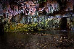
6.8 miles NW of Sonora, CaliforniaNatural Bridges is one of the most magical swimming spots in California's Gold Country — a pair of massive limestone caverns that Coyote Creek has tunneled straight through the hillside, forming natural rock bridges you can actually swim and float beneath. Hidden in the oak-covered foothills of Calaveras County near Vallecito (between Sonora and Angels Camp), it's a beloved local secret and, unlike most of the region's show caves, completely free and open to the public.
The reward takes a bit of work to reach. From the trailhead off Parrotts Ferry Road, a roughly 2-mile round-trip hike drops down through the hills to the creek and the mouth of the cavern. Along the way you get views of the surrounding country, and the trail continues up and over the top of the bridge for those who want to explore both the water below and the formation above.
At the creek, the real adventure begins. Coyote Creek flows right through the 250-foot travertine cavern, and depending on water levels you can float or swim through the tunnel from one end to the other, drifting through cool, dim chambers and deep green pools with the limestone arching overhead. On a hot Sierra-foothills summer day it's an unforgettable experience — part swimming hole, part cave exploration — and many people bring inflatables to float the passage.
Go carefully, and help protect it. The rocks are slick, the water depth and current change with the season (the creek can run high and cold in spring), and swimming through a dark cavern carries real risk — only go when the water is calm and low enough, never alone, and check depth before jumping anywhere. Just as important, this is a living limestone formation: the oils on human skin, along with graffiti and litter, genuinely damage it, so avoid touching the cave walls where you can, pack out every scrap of trash, and tread lightly. The site is cared for by the Bureau of Reclamation and conservation groups precisely because heavy use threatens it.
There are actually two bridges — an upper and a lower — and Coyote Creek eventually flows on to New Melones Lake. The whole of Calaveras County is honeycombed with caves and caverns, most of them commercial show caves you pay to tour, which makes this free, wild swim-through all the more special.
Timing and preparation matter. Summer into early fall is the prime, safest window, when the creek is low and warm; it also draws crowds, so arrive early. Wear sturdy shoes with grip for the rocky trail and slick cavern, bring water and sun protection for the exposed hike, and consider water shoes and a light for the swim-through. Come respectful and prepared, and Natural Bridges delivers a genuinely rare thrill — swimming through a cave carved by a creek, in the heart of California's historic Gold Country.

Table Rock / Table Mountain
Driggs, Idaho
10.0 miles E of Driggs, IdahoAt roughly 11,100 feet, the flat-topped summit of Table Mountain serves up what many consider the single finest view of the Grand Teton anywhere — and one of the great day hikes on the quiet, western (Idaho) side of the range. From the broad mesa top you stand just far enough back to take in all three Teton peaks at once, yet close enough to pick out the detail on the Grand's sheer east face across the deep gulf of the canyon. It's a jaw-dropping payoff, and a hard-earned one.
The mountain holds a remarkable place in history. In 1872, pioneering survey photographer William Henry Jackson hauled his heavy glass-plate camera gear by mule to the top of Table Mountain and made the first photographs ever taken of the Grand Teton — images that helped introduce the range to the wider world and build support for protecting it. Jackson chose this peak precisely because its gentle western slopes could be reached without technical climbing, and that's still what makes the summit attainable for strong day hikers today.
The trailhead sits at the end of Teton Canyon Road outside Driggs and Alta, and nearly the entire route lies within the Jedediah Smith Wilderness of the Caribou-Targhee National Forest. There are two main ways up, and both climb over 4,000 feet. The Face Trail is the steeper, shorter option (about 3.5 miles one way), skipping the switchbacks to head more or less straight up. The Huckleberry (North Fork) Trail is longer but far more gradual (about 6.5 miles one way), following and crossing the North Fork of Teton Creek — handy spots to filter water — through meadows and, in mid-to-late summer, ripe huckleberries for those who beat the crowds to the bushes. Many hikers link the two into a big loop of roughly 11–13 miles, and tough-but-knee-conscious hikers generally prefer to climb up the steep Face and come down the gentler Huckleberry, sparing their knees the pounding of a steep descent. The lower trail is a delight in its own right, tracing rushing Teton Creek past a string of waterfalls.
The wildflowers here are spectacular. As the snow recedes, Table Mountain's meadows erupt in color — sweeping displays of lupine, arrowleaf balsamroot, and Indian paintbrush, with columbine in the shadier pockets and delicate alpine blooms up high. In the Tetons the canyon meadows tend to peak from early-to-mid July, while the highest ground saves its show for late July into August; even when snow still blocks the upper trail, the lower meadows near the trailhead put on an easy, photogenic display. It's one of the finest wildflower hikes in the region.
This is high, exposed country, so plan accordingly. At over 11,000 feet the air is thin and the weather changes fast: afternoon thunderstorms build quickly over the peaks in summer, so start early and aim to be off the open summit by early afternoon. Table Mountain is enjoyed year-round — it's a popular snowshoe and backcountry-ski destination in the snowy months. If you're after dry summer hiking, though, know that you're likely to encounter snow on the upper mountain before mid-July: early-season snowfields often begin around 9,500 feet with larger patches up high, and the Huckleberry side can hold avalanche debris and downed trees until it melts out. It's frequently still passable with the right footwear — just come expecting it. Conditions are typically most reliably snow-free from about mid-July through September. It's also easy to lose the trail, especially on the descent, so pay attention to your route and carry a map or GPS. Keep an eye out for wildlife, too — moose are a common sight in the canyon, and the area is home to the occasional mountain lion.
Bring layers, sun protection, plenty of water (and a filter), and sturdy footwear for the long, steep grade. You can check current conditions on the webcams at tetoncam.com before you drive up. Backpackers sometimes camp in the meadows below the summit to catch the Grand at sunrise — an unforgettable sight — while following Leave No Trace and wilderness regulations. However you do it, Table Mountain earns its reputation: a leg-burning climb to a mesa in the sky, carpeted in wildflowers, with the Grand Teton filling the horizon just as it did for Jackson a century and a half ago.

Kelly Mountain Trail
Ririe, Idaho
8.2 miles E of Ririe, IdahoThe Kelly Mountain Trail climbs the slopes of Kelly Mountain in the Kelly Canyon area near Ririe, Idaho — a popular local recreation spot in the foothills east of Idaho Falls, best known for its small ski resort and its web of trails. This route switchbacks up the mountain to a summit that rewards the effort with sweeping views in every direction across the surrounding hills, forests, and the South Fork Snake River country below.
It's a moderate, mostly uphill trail of roughly 3 miles, gaining somewhere around 900 feet as it climbs through a diverse and pretty landscape — lush forest, wildflower meadows, and creekside stretches that make for good birdwatching and the occasional wildlife sighting. A couple of short, steeper “red-line” pitches get the heart pumping before the grade eases near the top. It's used by hikers, mountain bikers, and others depending on the season, and dogs are welcome on a leash.
An important note on trail status. Much of the Kelly Canyon trail network sits on U.S. Forest Service land, and not all of these routes are officially designated or sanctioned for every use. In particular, the status of mountain biking on some of this ground has been contested — riders have reported enforcement and the risk of steep fines — so if you plan to bike, check the current official trail designations and any posted signage before you ride rather than assuming access. For hikers on foot the situation is generally more straightforward, but it's always wise to confirm current conditions.
The area shines in summer and early fall, roughly June through September, when the wildflowers are out and the high country is dry; the same slopes turn into ski runs once the snow flies. Mornings are cooler and quieter, and the light on the surrounding hills is especially pretty early and late in the day.
The broader Kelly Canyon area is a genuine four-season playground. In winter the little Kelly Canyon Resort runs its lifts for skiing and tubing, and in the warmer months the surrounding hills draw hikers, riders, and ATV users onto a sprawling network of routes. That popularity is part of why the land-use questions matter here — a lot of people share this ground — so a little courtesy and a little homework go a long way toward keeping everyone welcome.
Come prepared for a foothills climb: bring plenty of water (there's little shade on the exposed upper switchbacks), sun protection, and sturdy footwear, and watch for afternoon heat in midsummer. Keep dogs leashed and under control, yield appropriately on shared sections, and pack out everything you bring. For a quick, rewarding leg-burner with big views close to Idaho Falls, Kelly Mountain is a longtime local favorite — just do your homework on current trail rules before you go.

Webster's Dam
Ririe, Idaho
9.8 miles NE of Ririe, IdahoAlso known as Manmade Falls or the Woodmansee Dam, Webster Dam is an abandoned dam located deep in Moody Creek canyon, the dam was abandoned when sediment built up behind the dam which then caused the stream to split and flow around both sides of the dam, creating two beautiful waterfalls each about 15 feet in height. This makes a fun evening trip and is good for almost any time of the year as well. It's beautiful in the spring with powerful falls from the spring runoff and in the fall, there are plenty of fall colors along the pole line trail and around the waterfalls. At the falls, you'll find two waterfalls coming over each end of the dam. On the south end of the dam there is a bridge that spans the creek on that side. There is a little island in the middle where you can sit on the rock wall and take in the whole scene.
There are two trails which weave back and forth a couple of times so you can really choose your route a little bit. The main parking area is at the top of the hill by pole line and that's also the most common trailhead. The pole line trail follows the ATV road with several ups and downs. For the most part its a fairly rounded out and bermed double track awesome for mountain bikes and ATVs. For much of it, there's a hiking trail that follows along the side of it. However you travel this trail, be very aware of other riders and hikers which can seem to appear out of nowhere. The trail continues along the power pole lines for just over 3/4 miles, then turns left just as the balls on the power lines come into view. After a couple hundred feet, you'll see the other trail merge into this one from the left and then take off again to the right about 150 yards later. Keep left on the "pole line trail" for a more gradual decent or go right on the "wooded trail" for a more adventurous and much steeper route. The pole line trail go out and hook back taking you straight to the falls.
The wooded trail trailhead is Northwest of the pole line trail. It's a less used ATV track that goes back and forth between the woods and the pole line until it merges with the pole line trail about 3/4 miles in, only to split to the right 150 yards later. In another 100 yards, you'll come across another junction; keep left. In another 150 yards it will come back together with the pole line trail and continue all the way to the falls. On the upper portions, this trail is has a lot fewer ups and downs making it a more gradual hike. After merging with the pole line trail though, this trail becomes the much steeper option.
Whichever of these 2 paths you choose, the last 1/3 mile descent is more like a chunky forest road than the double track above. It has some pretty steep parts, some chunky rock sections, and some rollers that make great mountain bike jumps. While it's a little steep and chunky, most intermediate riders should be able to handle it just fine. At the bottom just before the falls are some very large dirt jumps off to the side. The last 30 yards to the falls after the dirt jumps is much more janky, probably more like a black diamond on a bike but not too tricky to get down on foot.
The third option is much longer, starting at the warming cabin on Brown's Road. It's an intermediate trail to the creek and then a green (easy) trail along the creek to the dam.
A very popular route to do this on a mountain bike is to loop it starting either at the warming cabin or the top of the pole line and riding down the pole line to the waterfall and then out Mad Cow and up Cabin Climb to complete the loop.
This can be a great family hike. Plan on 2-4 hours to hike it with little ones, depending on how fast and tough they are.

Warm Slough Campground
Rexburg, Idaho
5.0 miles NW of Rexburg, IdahoThis is a pretty popular campsite that fills up pretty quick on busy weekends. Campsites are fairly spread out and there is no official donation box (as of July 2015). A couple of the campsites have picnic tables and there are several rock fire rings. There's also a restroom next to each boat ramp.
It's a popular put in and takeout spot on the river with two boat ramps, one on the creek and one on the river. There's also a pretty good spot to take out innertubes just under a mile downstream from the boatramp that's on the river, yet the boat ramp and takeout are only about 1000 feet away from each other which makes it really easy to do over and over again. There's another put-in further upstream that will almost double your float but also significantly increase your walk back. It's a pretty slow easy float and the water isn't super cold.
This used to be a popular spot for paintball which is now prohibited. Please take better care of the paintball fields we are permitted to use.

Fifth Water Hot Springs
Provo, Utah
19.0 miles SE of Provo, UtahFifth Water Hot Springs — better known to generations of Utahns as Diamond Fork Hot Springs — is one of the most beloved soaks in the state: a series of steaming, blue-green mineral pools tucked beside a waterfall in a pretty canyon southeast of Provo. A scenic drive up Diamond Fork Canyon and a riverside hike of about 2.5 miles each way lead to the reward, where hot water tumbles down a travertine hillside into a staircase of rock pools ranging from pleasantly warm to a toasty 105–110°F at the source.
The pools sit right where Fifth Water Creek meets a small waterfall, and part of the fun is choosing your spot. As you come into view of the falls you'll see a few pools perched just above the creek; more line the base of the waterfall, including shallow soakers and spots where you can nudge the rocks around to mix hot spring water with cool creek water and dial in your own temperature. Wander behind and beyond the waterfall and you'll find a couple of quieter, more secluded pools — just watch the slick, mineral-coated rock, which can be treacherously slippery. The water carries a faint sulfur smell and stains everything a milky blue-green; it's all part of the character.
A few practical notes make the trip smoother. There's nowhere private to change at the springs, so most people hike in their swimwear (and on a sunny day you'll dry off easily on the walk out). Bring water shoes or sandals if your feet are tender — the rocky pool bottoms and short scrambles are much friendlier with something on your feet. This is a relaxed, come-as-you-are place with a longstanding clothing-optional streak, so groups with kids may occasionally encounter suit-free soakers, especially on quiet weekdays.
Timing matters more here than at most hikes. The Diamond Fork Road gate closes for winter (typically from around November into late spring), and when it's shut the hike balloons to roughly 12–13 miles round trip — a popular but serious snowshoe or ski outing rather than a casual stroll. When the road is open, it's about a 5-mile round trip. Fall, winter, and spring are the sweetest seasons: cooler air makes the hot water far more inviting and the crowds thinner. The springs are busiest on weekends and holidays, so go early or midweek if you can, and note that a trailhead parking fee has been proposed for this popular spot, so come prepared for one.
Come prepared and tread lightly. Rattlesnakes are active along the sun-warmed trail in the warmer months — on a hot day you may well spot several snakes, most of them harmless, so simply watch where you step and reach. Carry plenty of drinking water — a long hot soak is dehydrating — and pack out everything you bring; broken glass and litter have been a real problem here, and keeping this gem clean is on all of us. Dogs are welcome on the trail. With a little planning, Fifth Water rewards you with one of the finest hot-spring soaks in the Wasatch — a waterfall at your back, canyon walls above, and warm mineral water swirling all around.
Palisades Hot springs
Swan Valley, Idaho
18.3 miles SE of Swan Valley, IdahoPalisades Hot Springs is one of eastern Idaho's more elusive soaks — a set of natural hot springs on the shore of the vast Palisades Reservoir, near Swan Valley on the Idaho–Wyoming border. Here's the catch that surprises many visitors: for most of the year, the springs are underwater, submerged beneath the reservoir that flooded this stretch of the Snake River when Palisades Dam was completed in 1957.
That's why so many people go looking and come away empty-handed. The hot water is real, but whether you can actually soak in it depends entirely on the reservoir's level. In seasons when the lake is drawn down low enough — typically late summer and fall, as irrigation demand shrinks it — the warm springs can re-emerge along the exposed shoreline, and lucky visitors find steamy water bubbling up where the lake bed meets the bank. When the reservoir is full, there's simply nothing to find.
Because of that, Palisades Hot Springs is best thought of as a conditional, hit-or-miss destination rather than a reliable soak. The springs are generally reached by boat across the reservoir to the right stretch of shore, so it's an outing that rewards local knowledge, low water, and a bit of luck. Check current reservoir levels before you build a trip around it — if the lake is high, save the hot-spring hunt for another year and simply enjoy Palisades Reservoir itself.
And there's plenty to enjoy. Palisades is a stunning 16,000-acre mountain reservoir with some 70 miles of shoreline, ringed by the peaks of the Snake River and Caribou ranges — a magnet for boating, paddling, camping, and fishing (it's known for cutthroat, lake trout, and kokanee). The scenery alone makes the trip worthwhile whether or not the springs are showing.
It's worth setting expectations about what “hot springs” means here. Even when the water is low enough to expose them, these are undeveloped natural seeps along a muddy, rocky reservoir shoreline — not tidy soaking pools. You may find pockets of pleasantly warm water mingling with the cold lake, but conditions vary wildly from year to year, and in high-water years the springs stay hidden entirely. Locals who've found them treasure the experience precisely because it's so unpredictable, and if a guaranteed soak is what you're after, eastern Idaho has far more reliable options — which makes this a fun bonus rather than the main event.
If you do go hunting for the hot water, come prepared for a full day on the lake: bring plenty of drinking water, sun protection, and a reliable way to navigate to the spot, watch the weather and boat traffic on the open reservoir, and temper your expectations. Palisades Hot Springs is less a sure thing than a fun local legend — a warm-water treasure the lake gives up only when conditions are just right.
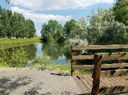
Rexburg Nature Park
Rexburg, Idaho
0.8 miles NW of Rexburg, IdahoRexburg Nature Park:
Life can be stressful, annoying, or just not good. Sometimes, it takes a moment to simply get away from the non-sense of this world; to gather yourself and seek peace and tranquility. That option is around the corner; you drive and see a trail, so you park and walk on the trail. As you walk, there's trees and sunlight shining on the leaves. You walk further and see a pond with ducks (both green and brown) and families sitting on the green grass with their kids; they watch, feed the ducks and take pictures with a smile on their face.
You go back to your vehicle and reminisce what you saw. Close to the south fork of the Teton River, is a nature park that isn't crowded with college students or infested with incoming traffic but a 15 acre park that was made so you can take your family or acquaintances for a picnic or a social gathering and enjoy; you also have the option to ride your bike or to jog on the trails.
The park is next to the Claire Boyle skate park, a beautiful golf course next to the fairgrounds and a 9 hole Frisbee golf course.
Features:
-Playground for the kids
-Fishing ponds ( A valid fishing license is required); fishing ponds for children as well.
-Wildlife and wildflowers
For more information and questions:
| Phone | 208-359-3020 Ext. 0 |
|
customerservices@rexburg.org |
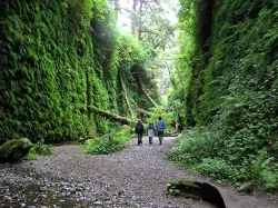
Fern Canyon
Orick, California
7.9 miles N of Orick, CaliforniaFern Canyon is one of the best 1-mile hikes that you can do in California! This unforgettable location was featured in Steven Spielberg's film, Jurassic Park: The Lost World.
Fern Canyon is located in Prairie Creek Redwoods. It's not incredibly easy to find, but the remote 8-mile drive will be worth seeing this fern laden paradise. Two stream crossings will need to be done by car, but one of these streams can be about 6 inches deep. If you don't think your car can make it, you'll just have to park and walk an extra mile.
Since this drive is pretty much in the middle of nowhere, you may see a lot of wildlife. You will most likely see a lot of elk on this drive so it's important to drive slowly on the dirt road. Also be aware of potholes along the road.
The drive is the most difficult part of this trip, so the hike is going to be a piece of cake in comparison. There is a parking lot with a vault toilet and a sign giving information about the area. The level trail begins at the top of the parking lot and leads you through a small, moss-covered forest before you reach the canyon. Be prepared to get wet during your hike because you will have to cross more streams. Don't try to find a way around the water and just have fun with it. Since the trail is relatively flat, this hike is a perfect, fun adventure for those with small children. There are a few wooden foot bridges here and there to cross some of the streams, but it is probable you will get your feet wet at some point.
Once you reach the canyon, you will have 50-foot canyon walls towering over you. These walls have lush, green plants cascading down the sides and there are fallen redwood trees, green with moss. You will possibly have to climb over or under a few logs. Along the canyon walls, there are some little waterfalls and streams that trickle down through the foliage. You will feel as if you are walking through a rainforest in Fern Canyon. No wonder a scene from the Jurassic Park movie was filmed here!
Going through the canyon itself is only about a half a mile, but the trail continues on and flattens out again into a forest. You can hike the whole loop trail or you can go back the way you came if you want to experience the canyon again (who wouldn't?).
Make sure you add this magical place to your list of places to see!
NOTE: Leave early in the morning to avoid the crowds. Bring water shoes or sandals.

Garden of Eden
Felton, California
2.0 miles SE of Felton, CaliforniaThe Garden of Eden is a beloved swimming hole tucked into the redwoods of Henry Cowell Redwoods State Park near Felton, California, in the Santa Cruz Mountains. Strung along the San Lorenzo River beneath towering redwoods and Douglas firs, this sun-dappled oasis — with its clear green pools, little sandy beaches, and rocky ledges — has been a favorite Santa Cruz summer escape for generations.
It's an idyllic spot to spend a warm afternoon: swim in the cool river, sunbathe on the rocks and small beaches, and watch the light filter down through the redwood canopy. Some ledges draw cliff-jumpers when the water is deep enough, though “No Diving” signs are posted for good reason — more on that below.
Getting there is a little adventure with an important catch: the most common route follows an active railroad line (the Roaring Camp scenic railway). From the Ox Trail parking area off Highway 9, you hike down and then walk along the train tracks for about a mile to reach the swimming hole. These tracks are active and trains do run — people have been seriously hurt and killed here. Stay alert, step well clear of the tracks whenever a train approaches, skip the headphones, and keep kids close. And heed the “No Diving” signs: always check the depth before entering, since the river bottom and water level change.
A few more notes: there are no restrooms or trash cans, so pack out everything you bring in, and dogs are not permitted. Arrive early on summer weekends, as roadside parking fills fast. Summer and early fall, when the river warms and the flow settles, are the best times to visit. Mind the trains, respect the river, and the Garden of Eden rewards you with one of the most beautiful swimming holes in the Santa Cruz Mountains.

Glacier Point
Yosemite National Park
9.6 miles S of Yosemite National ParkLocated in Yosemite National Park, Glacier Point gives a birds-eye-view of the park you can't find anywhere else. It can be accessed by both hiking and driving through the park, though the roads may be closed until early to late May due to snow. Glacier Point towers over Yosemite Valley, sitting at 7,214 ft compared to the 4,000 ft valley floor.
From Glacier Point visitors are able to see the famous Half Dome, Vernal Falls, Nevada Falls, Yosemite Falls, El Capitan, and the Yosemite High Country. Each season offers a different view and feel for visitors. Come in the winter and you will see a snow covered Half Dome and High Country. Spring comes with the promise of new green leaves and roaring, snowmelt fed waterfalls. The summer still offers plenty of views, though a lot of tourists will be visiting. Fall brings a change of leaves throughout the park, and so it provides a beautiful contrast to the granite cliffs all around.
The trails to get to Glacier Point are the Four Mile Trail and the Panoramic Trail. The Four Mile Trail starts at the valley floor and like the name says, it is about 4.7 miles one way. Hiking up to Glacier Point has a significant level of elevation gain (Valley Floor is 4,000 ft and Glacier Point is 7,214 ft). The trail offers views of the Yosemite Valley that belong in a postcard. Those who hike to the top can enjoy an ice cream at the general store, while taking in the views. On the way down, hikers will see Yosemite Falls constantly in front of them, while the other sights of the valley floor come into view as the trail descends.
The Panoramic Trail is an alternative for going down from Glacier Point. Many hikers alternate between taking the Four Mile Trail up and the Panormaic Trail down (or vice versa). While the sights of the Four Mile Trail include many of the valley floor sights, the Panoramic Trail offers views of Illilouette, Nevada, and Vernal Falls. The trail ends at a different point than the Four Mile Trail, but hikers can take one of the free shuttles throughout the park.

Twin Bridges
St. Anthony, Idaho
6.6 miles NE of St. Anthony, IdahoTwin Bridges is a beloved bridge-jumping and swimming spot on the river near St. Anthony, Idaho — a summer institution for families, teens, and college students across the upper Snake River Valley. The name comes from the setup: an old abandoned bridge stands right beside the one still in use, and the deep, slow water beneath the old span makes for about the best bridge jumping around, with no traffic to dodge and easy parking nearby.
The jumping is the main event, and it's well suited to a range of nerve. There are two distinct levels to leap from — a lower point around 11 feet and a higher one around 17 feet — so you can start small and work your way up, and the water below is plenty deep for cannonballs, flips, and gainers. Locals consider it about as good and as “reasonably safe” as bridge jumping gets, with one firm caveat: keep clear of the rocks along the sides, which can be exposed depending on the water level.
There's more to it than jumping. A little rope swing often hangs under the bridge — a favorite of the little kids — and a path up the river makes a good put-in for a short, mellow float back down. For families with young children, there's a sandbar on the north side just upstream of the action, perfect for wading and splashing away from the jumpers. The slow current is ideal for simply hanging out in the water while you watch your friends show off.
A fun local curiosity: downstream of the little rock dam on the north side lie the sunken remains of an old car, washed here after an accident years ago. When the water is low and clear you can spot its chrome bumper from the rocks and swim down for a look — a quirky bit of underwater sightseeing that regulars love.
Part of the appeal is how welcoming and community-minded the spot is. Generations of upper-valley families and Rexburg-area college students have made Twin Bridges their go-to summer swimming hole, and there's a friendly, everybody-shares-the-water vibe on a busy afternoon. It's the kind of simple, free, small-town summer pleasure that keeps people coming back week after week.
A few practical notes: it's a popular place, so expect a crowd on hot, sunny days and holidays — though it handles a lot of people well, and you rarely wait long to jump. Bring water shoes for the rocky spots, sun protection, and drinking water, always check the water depth and clear your landing before jumping (levels change through the season), keep an eye on kids near the current, and pack out all your trash. For a classic, easygoing eastern-Idaho swimming hole, Twin Bridges is hard to beat.

Monkey Rock
Saint Anthony, Idaho
4.1 miles SE of Saint Anthony, IdahoMonkey Rock features a beautiful waterfall you can wade right up to during the summer. Just under the waterfall is a great spot to wade around in or even some shallow swimming pretty good for small children. Maybe you just want to take advantage of the great bank to bask in the summer sun. The water temperature is fairly cool, which by no means is unwelcomed during the hot summer months. You'll get used to the water fairly quickly once you're in. The waterfall is a fun feature at Monkey Rock, not to mention a popular engagement photo backdrop. The name "Monkey Rock" is derived from the "monkeys" who jump off the rocks at the top of the falls to the pool below. Though not a great height, it's important to be careful and only jump into areas clear of rocks and other hazards and where the water is deep enough that you won't hit bottom when you jump. There really isn't a safe spot to jump from the falls as it doesn't usually get more than 5 feet deep.
The real jumping location is off the Hog Hollow Bridge up the road from the waterfall.
PLEASE NOTE: On the roads leading to Monkey Rock, the speed limit is 35 mph for the last mile. There are kids, cows, horses, and dogs along that road and many people tend to speed going to and from Monkey Rock. Please slow down and stay safe.
Teton Springs Trail
Victor, Idaho
2.1 miles S of Victor, IdahoTeton Springs Loop is a loop for cross-country skiing and snowshoeing. The loop is connected to the Teton Springs Resort, but is open to the public for free access. The trail starts on the South side of the Teton Springs Resort East Parking Lot.
The loop is 5.5 miles long with very little elevation change. It is a great place for beginners to practice snow shoeing and cross-country skiing. Teton Springs Loop loops around what during summer months is Teton Springs Golf Course.
The loop is frequented by many types of wildlife. Elk, moose and water fowls are frequently seen near the trail.
Teton Springs Loop is a wonderful trail for those in search of a wintertime adventure. It is easily accessible from the Rexburg and Idaho Falls Areas. This easy access makes this a wonderful way to connect with nature in the cold.
Trail Map: Teton_Springs_Map_2015.pdf
Grooming Report: http://tvtap.org/nordic-grooming
Driggs Nordic Trail
Driggs, Idaho
0.9 miles NE of Driggs, IdahoThe Driggs Nordic Trail is a friendly, in-town cross-country ski network right in Driggs, Idaho, in the heart of the Teton Valley — a perfect place to click into skis for an easy glide with the jagged backside of the Tetons rising on the horizon. Groomed and beginner-friendly, it's a local favorite for a quick ski before work, a family outing, or a first taste of Nordic skiing without heading into the backcountry.
The trail system offers three loops totaling about 6 kilometers, most of it pleasantly flat and forgiving, with just a few small hills along the North Plateau loop for a bit of variety. That gentle terrain makes it ideal for newcomers, kids, and anyone looking for a relaxed workout on classic or skate skis. Dogs are welcome, too, as long as they're kept under control and within voice command — a rare and appreciated perk on groomed Nordic trails.
You'll find the trailhead parking area on the east side of Booshway Avenue, between LeGrand Pierre Avenue and Ross Avenue — an easy, central location just minutes from downtown Driggs. Because it's right in town, it's simple to pair a ski with a stop for coffee or a bite afterward.
The trails are lovingly maintained by Teton Valley Trails and Pathways (TVTAP), a local nonprofit that grooms the community's winter trails — typically on Tuesdays, Thursdays, Saturdays, and Sundays as conditions allow. Because that grooming runs on donations and volunteer effort, it's worth checking TVTAP's current grooming report before you head out, and chipping in a few dollars to support the work that keeps these trails skiable.
The Driggs Nordic Trail is just one thread in Teton Valley's rich winter-trail network. TVTAP grooms a whole system of community pathways around Driggs, Victor, and Alta, and the world-class terrain of Grand Targhee Resort and the groomed roads of Teton Canyon are a short drive away for those wanting bigger days and bigger views. That makes the in-town trail a great warm-up or an easy default when time is short — and a welcoming place for visitors staying in Driggs to find their ski legs before venturing farther afield. On a bluebird winter day, with the Tetons glowing to the east, it's hard to beat.
Come prepared for winter in the high valley: dress in layers you can shed as you warm up, bring water and sun protection (the mountain sun is strong off the snow), and check conditions, since freshly groomed corduroy versus icy or wind-scoured snow makes a big difference. The season generally runs from about December into March, depending on snowpack. Whether you're learning to ski, keeping the kids busy, or just soaking in those Teton views on a crisp winter morning, the Driggs Nordic Trail is one of Teton Valley's easiest and most welcoming winter escapes.


