


Refine Search
- swim 65
- hike 52
- camp 23
- mountain bike 14
- hot springs 13
- kayak 12
- canoe 12
- cave 8
- whitewater 4
- horseback 3
- backpack 3
- snowshoe 1
- cross-country ski 1
- skateboard 1
- rock climb 1
- disc golf 1
- dive 1
98 locations
Add Location
 Full Listing
Show more
Skateboard
Full Listing
Show more
Skateboard
 Full Listing
Show more
Swim
Full Listing
Show more
Swim
 Full Listing
Show more
Swim
Full Listing
Show more
Swim
 Full Listing
Show more
Canoe, Hike, Kayak, Whitewater
Full Listing
Show more
Canoe, Hike, Kayak, Whitewater
 Full Listing
Show more
Swim
Full Listing
Show more
Swim
 Full Listing
Show more
Camp, Canoe, Kayak, Swim
Full Listing
Show more
Camp, Canoe, Kayak, Swim
 Full Listing
Show more
Swim
Full Listing
Show more
Swim
 Full Listing
Show more
Hike, Swim
Full Listing
Show more
Hike, Swim
Lemont Skatepark
Lemont, Illinois
1.4 miles S of Lemont, IllinoisThe Lemont Skatepark is a public skatepark in the village of Lemont, Illinois, in the southwest suburbs of Chicago, set within the community's well-loved Centennial Park. Run by the Lemont Park District, it's a friendly neighborhood spot for local skateboarders, and part of one of the area's biggest recreation hubs.
The skatepark gives Lemont's skaters, scooter riders, and BMX crowd a dedicated place to session close to home, with a mix of features to practice on and progress. What really sets it apart is everything around it: Centennial Park is a comprehensive recreation complex with tennis and basketball courts, a swimming pool, numerous baseball and soccer fields, an ADA-accessible playground, a butterfly garden, and the Centennial Community Center with a gym and dance studio. That makes it easy to turn a skate session into a full day out for the whole family.
As a free public facility, it's an accessible, welcoming place to skate. As always, gear up with a helmet and pads (especially younger skaters), be courteous and take turns with everyone sharing the park, bring water, and check for any posted hours or rules. Convenient and family-friendly, the Lemont Skatepark is a solid neighborhood spot in the southwest suburbs.
Buena Vista
Lebanon, Kentucky
4.4 miles SW of Lebanon, KentuckyBuena Vista is a scenic swimming and wading spot on the beautiful Rolling Fork River in the rolling countryside of central Kentucky, near the small towns of Calvary and Lebanon in the heart of the Bluegrass State. A favorite of local paddlers and swimmers — and a popular stop for those floating the Fork — it's a peaceful, natural place to cool off on a hot Kentucky afternoon.
Here the Rolling Fork meanders through limestone bedrock, which creates smooth stone surfaces and shallow, inviting pools that are perfect for wading and splashing. The spot is marked by a picturesque rocky cliff along the river and the old Lebanon Water Works intake structure — no longer in use — which give the area its distinctive character. It's a lovely place to swim, float, picnic on the rocks, or launch a lazy paddle downstream.
Getting there involves a short walk through a hayfield, which can be uneven or muddy after rain, and there are no facilities on site, so come prepared with your own water, food, and gear, and pack out everything you bring. As with any natural river swimming hole, there are no lifeguards: watch children closely, check the depth and current before wading in (the river runs higher and faster after rain), and wear water shoes for the rocky bottom.
Late spring through early fall, when the water is warm and the weather stable, is the best time to visit. Quiet, natural, and easygoing, Buena Vista is a delightful slice of rural Kentucky river country.
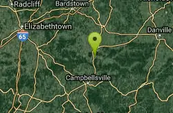
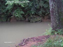
Temple Hill Area
Butler, Kentucky
154.5 miles SW of Butler, KentuckyTemple Hill — better known to locals as Happy Hollow — is a beloved old-fashioned swimming hole on the river near Butler, Kentucky, in the rolling countryside of the state's northern bluegrass region. Generations of families have come here to cool off on hot summer days, drawn by a deep, lazy stretch of river and a friendly little sandy beach right by the Happy Hollow Road bridge.
The setting is pure small-town summer. At the swimming hole, the river runs deep and slow, with cool, refreshing water that stays comfortable even through the dog days of summer. A small sandy beach makes for an easy place to wade in, spread out a towel, and relax, while the calm, deep water is great for a leisurely swim. There aren't any big jumping or diving spots, but you won't miss them — this is a place for floating, splashing, and unwinding.
It's an easygoing, free local favorite, found near the Happy Hollow bridge. As with any natural swimming hole, a few common-sense cautions apply: there are no lifeguards, so swim with a buddy and keep an eye on children; check the depth and current before wading in, especially after rain when the river can rise; and wear water shoes, since river bottoms can be rocky or muddy.
Summer is the season, when the water's warm and a cool dip is just the thing. Bring a picnic, sunscreen, and a tube or float for the slow water, pack out all your trash to keep this local gem clean, and enjoy one of northern Kentucky's classic, low-key swimming holes.
Bullpasture Gorge
Williamsville, Virginia
1.7 miles NW of Williamsville, VirginiaBullpasture Gorge is a wild and beautiful river canyon in the remote western highlands of Virginia, where the Bullpasture River carves a dramatic gorge through Highland County near Williamsville. A favorite of whitewater paddlers and hikers alike, it's the scenic centerpiece of the Highland Wildlife Management Area — rugged, uncrowded, and full of mountain character.
For paddlers, the gorge offers about three miles of exciting whitewater, with rapids ranging up to Class III, IV, and even V at higher flows — a serious run best left to experienced kayakers and rafters with the skills to match. For everyone else, foot trails wind through the gorge and over Bullpasture Mountain, including a dramatic cable suspension footbridge across the river, and the stocked trout waters draw anglers from across the region.
A couple of important access notes. Because this is a state Wildlife Management Area, everyone 17 and up needs a valid access credential to visit — a Virginia hunting, fishing, or boating license, a DWR access permit, or a Restore the Wild membership. Reaching parts of the gorge also requires fording the Bullpasture River, which can be dangerous at high flows, so use caution and stay out when the water is up. During hunting seasons, wear blaze orange for safety.
Spring brings the biggest water for paddling, while summer and fall are lovely for hiking and fishing. Come prepared for the backcountry, watch the river levels, and pack out everything you bring in. For whitewater thrills or a quiet mountain hike, Bullpasture Gorge is one of western Virginia's hidden gems.
Blue Hole Bergton
Bergton, Virginia
0.9 miles SE of Bergton, VirginiaBlue Hole is a classic small-town swimming and picnic spot near Bergton, Virginia, set at the headwaters of the North Fork of the Shenandoah River in the George Washington National Forest of rural Rockingham County. A beloved local gathering place for generations — legend even has it that a teenage George Washington passed through while surveying the area — this free, easygoing day-use area is a quintessential slice of Shenandoah Valley summer.
The setting is shady and scenic: a mountain river pooling up beside a grassy picnic area, tucked into the forested hills along Route 259. It's a relaxed place to wade, splash, cast a line, and spread out a picnic on a warm afternoon, with cool national-forest water and quiet country all around.
One honest note about the swimming: years of flooding and erosion have gradually filled in the old deep hole with sediment and rock, so the water is shallower than it once was, with rocks now exposed in places. Diving is no longer allowed here — always wade in and check the depth, and keep an eye on kids in the moving water. (Local leaders have talked about restoring the hole to its former depth, so conditions may improve over time.)
To get there, follow I-81 to Exit 257 near Harrisonburg and take Route 259 west through Broadway toward Bergton, watching for the Blue Hole Picnic Area sign. There's no fee. Summer is the season for a dip; spring and fall are lovely for a quiet picnic by the river. Pack out everything you bring in, respect the no-diving rule, and enjoy one of the upper Shenandoah Valley's most enduring little swimming and picnic spots.
Lee Creek Access
Chester, Arkansas
8.6 miles W of Chester, ArkansasLee Creek Access is a beloved Ozark swimming hole tucked into the wooded Lee Creek Valley near Chester, Arkansas, just downstream from Devil's Den State Park. With smooth, clear water, a wide creek, and a sandy beach perfect for lounging, it's a favorite summer cooling-off spot for families and paddlers exploring the rugged hills of northwest Arkansas.
The creek offers a little of everything: shallow shoals and gentle pools that are great for little ones to splash and wade, deeper holes for older swimmers to take a real plunge, and plenty of smooth water for floating the day away. A beach area makes it easy to set up chairs, spread a picnic, and settle in, while the surrounding scenery makes it a genuinely pretty place to spend an afternoon.
It's also a fine spot to get on the water. The wide, smooth creek is well suited to kayaks and canoes, and the access point makes for an easy put-in or take-out. Just upstream, Devil's Den State Park — one of the best-preserved Civilian Conservation Corps sites in the country — offers cabins, camping, boat rentals, and miles of hiking, mountain biking, and horseback trails into the Ozark National Forest, so it's easy to turn a swim into a full weekend.
Summer is the season here, when the water is warm and inviting. Bring water shoes for the rocky creek bottom, sun protection, and a cooler, keep an eye on water levels and current (creeks can rise fast after rain), and pack out everything you bring in. Easygoing, scenic, and refreshingly uncrowded, Lee Creek is a quintessential slice of Arkansas Ozark summer.
Big Marys Creek Slide
Vesuvius, Virginia
2.5 miles S of Vesuvius, VirginiaBig Mary's Creek Slide is a delightful natural water park hidden in the wooded mountains near Vesuvius, Virginia, in the heart of the Blue Ridge between Staunton and Steeles Tavern. Carved over centuries by the steady flow of Big Mary's Creek, a smooth chute of rock forms a natural water slide that sends sliders gliding down into a cool, clear swimming hole below — all framed by towering hardwoods and tumbling little waterfalls.
It's a beloved spot for locals and visitors alike, and an absolute blast on a hot summer day. Ride the slide down into the pool, swim in the clear mountain water, and relax in the dappled forest shade. The setting is gorgeous and refreshingly low-key — a true old-fashioned Virginia swimming hole.
Slide smart and safe. Wear a swimsuit and foot protection (water shoes), since parts of the rock can be sharp, and always check the depth of the pool before you slide or jump in — water levels change with the season. Take your first run cautiously to learn the slide, keep an eye on kids, and never assume the water below is as deep as it was last time.
Reaching the slide involves following gravel forest roads and a short but steep path down to the creek, so wear sturdy shoes for the walk in. Summer is prime season, when the water is warm enough for sliding and the swimming hole is at its most inviting; spring brings stronger flows and fuller waterfalls. Pack out all your trash to keep this little gem pristine, and Big Mary's Creek Slide will reward you with one of the most fun natural swimming spots in the Virginia mountains.
Piney River
Sperryville, Virginia
4.6 miles NW of Sperryville, VirginiaTucked into the Blue Ridge Mountains of Shenandoah National Park near Sperryville, Virginia, the Piney River is a string of clear, cool swimming holes that reward hikers willing to head off the beaten path. Fed by mountain streams and shaped by the ancient bedrock of the Blue Ridge, the river carves a series of natural pools, chutes, and small cascades — an old-fashioned, crystal-clear mountain swim a world away from the summer crowds.
The swimming holes are reached on foot via the Piney Branch Trail, which drops from Skyline Drive (near milepost 22) down along the Piney River. As you follow the trail downstream, the water widens at several spots into pools deep enough for a refreshing dip, including a lovely one at the base of a small waterfall. The trail crosses the river at several points over uneven, rocky terrain, so sturdy footwear you don't mind getting wet is essential.
It's a quintessential Shenandoah experience: a moderate hike through a dense Appalachian canopy, the sound of running water the whole way, and the payoff of cool, clear pools tucked beneath the trees. The deeper you go, the more solitude you'll tend to find, so it's worth exploring a bit to discover your own favorite spot along the river.
Summer is prime swimming season, while spring brings stronger flows and the fullest waterfalls. Come prepared for a national-park backcountry outing: bring plenty of water, wear shoes with good grip for slick rock and river crossings, watch the weather since mountain streams can rise quickly after rain, and pack out everything you bring in. As the closest town to the park's eastern side, Sperryville makes a convenient base for lodging, dining, and supplies.
For a quiet, scenic, and genuinely refreshing escape, the swimming holes of the Piney River are one of Shenandoah's best-kept summer secrets.
Thundering Spring
Molena, Georgia
3.2 miles S of Molena, GeorgiaCLOSED. On private land within the Gerald I. Lawhorn Scouting Base (Camp Thunder) near Molena; not open to the general public — please don't trespass.
Full Listing
Show more
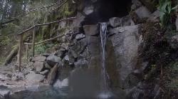
Hot Springs
Thundering Spring is one of Georgia's most intriguing natural oddities — a naturally warm spring tucked into the wooded hills near Molena, in Upson County. It earns its dramatic name honestly: the spring constantly burbles with rising gas bubbles, and the low, rumbling sound they make gives the place its “thunder.”
It's part of a little-known cluster of warm springs scattered between Pine Mountain and Barnesville — seven in all, including Taylor, Parkman, Brown's, Lifsey, and Baker, plus the most famous of the bunch, Warm Springs, where President Franklin D. Roosevelt sought out the soothing 88-degree water. Thundering Spring runs warmer than the region's ordinary creeks, fed from a source bubbling up in the middle of the pool and topped off by a small feeder stream.
The spring carries a remarkable piece of history, too. By most accounts, the wooden bathing structure once built over the pool in the 1840s is credited to Horace King — the celebrated master builder who was born into slavery, learned engineering, bought his freedom in 1846, and became the most respected bridge-builder across west Georgia and Alabama. Time has worn that old structure down, but the story is a window into the area's deep past.
Today Thundering Spring is more curiosity than swimming pool — a quiet, swampy, spring-fed pocket of warm water in a peaceful wooded setting, the kind of offbeat natural feature that delights spring-hunters and history buffs. Its steady gurgle and unusual warmth make it a genuinely memorable footnote in Georgia's geology and pioneer heritage.
Because it sits on private land, the way to appreciate Thundering Spring is with permission and real respect for the property. Arrange it the right way and you'll find one of Georgia's most unusual and storied warm springs — proof that some of the best natural wonders are the ones you have to seek out.
1.3-3.9 mi
 Full Listing
Show more
Hike, Mountain Bike
Full Listing
Show more
Hike, Mountain Bike
Lewis & Clark Caverns Trails
Whitehall, Montana
12.0 miles E of Whitehall, MontanaLewis & Clark Caverns State Park is a 3,000-acre park with over 10 miles of trails open to hikers and mountain bikers. It is easy to be one with nature as you explore these adventurous trails.
The trails in Lewis & Clark Caverns State Park come in a variety of difficulty levels. The easiest trail, Nature Loop Trail, is a quarter mile loop that can be easily completed in a short amount of time. Fishing Access Trail is a 1.3-mile trail from the park’s campground. This trail has about a 100-foot elevation gain. These trails are wonderful for hikers and mountain bikers looking for an easy route where you can connect with nature.
Some of the more difficult trails in Lewis & Clark include East Side Trail and Cave Gulch Trail. East Side Trail is an almost four-mile trail that stretches from the top of the park to the bottom, with an 831-foot elevation change. Cave Gulch trail is shorter, about two miles in length, and steeper with an over 1000-foot change in elevation. Parts of these trails very rocky or washed out making for an exciting ride.
Lewis & Clark Caverns State Park has the perfect set up for a shuttle. Most trails can be accessed from the main road at the top or at the bottom of the trail. All trails in the park are connected making it easy to have an all-day adventure exploring every trail.
9.1 mi
 Full Listing
Show more
Backpack, Camp, Hike
Full Listing
Show more
Backpack, Camp, Hike
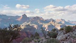
New Hance Trail
Grand Canyon Village, Arizona
12.5 miles E of Grand Canyon Village, ArizonaNew Hance Trail is a colorful hike through Red Canyon to the Colorado River. This trail is considered one of the more difficult trails in the Grand Canyon and is a challenge only prepared hikers should accept.
Hikers can expect to hike 9 miles out and back on New Hance Trail. Parking is available at Moran Point, and the trailhead can be found by walking west from the parking lot.
New Hance Trail’s difficulty stems from the steepness of the trail and from the lack of water sources along the trail. Hikers should bring plenty of water with them as well as filters for river water at the end of the trail. It is a steep climb down into the canyon and back up with over a 4,500-foot elevation change. It is recommended that the hike be taken in the spring or fall as there is not much shade and summer temperatures are high.
The trail is washed out and very rocky in some places. The hike forces hikers to climb down and up using both arms and legs in some places. Hikers can expect to spend some time climbing and some time walking as they hike on New Hance Trail.
Once the trail reaches the Colorado River the hike can be extended by hiking along Tonto Trail by the River. Most hikers camp in the primitive campsites near New Hance Trail and finish the hike over a couple days. The trail can be hiked in one day, about 8 hours of hiking, if hikers are prepared with plenty of supplies and give themselves ample time to rest.
The primitive campsites can be found in several places along New Hance Trail. These sites can be found mid-canyon near Redwall, where the trail descends into Red Canyon, and upriver from the trail at the Colorado River. These primitive campsites are for experienced campers and backpackers.
New Hance Trail is a challenging hike with open, stunning views. The cliffs of Red Canyon have colorful layers of history that have been revealed by the rushing Colorado River. This hike is a wonderful, challenging addition to any Grand Canyon visit.
2.6 mi
 Full Listing
Show more
Hike, Mountain Bike
Full Listing
Show more
Hike, Mountain Bike
Lone Star Geyser Trail
Old Faithful, Yellowstone National Park
3.1 miles S of Old Faithful, Yellowstone National ParkLone Geyser Star Trail is a hiking and mountain biking trail that leads through the forest to the colorful Lone Star Geyser. The Geyser here has beautiful white, yellow and orange colors in the surrounding rock buildup. The geyser erupts once approximately every 3 hours with an impressive 30-45 foot spray. Those who witness an eruption should note the time and report their sighting at the Old Faithful Visitor Education Center.
The trail is 4.8 miles round trip and allows bikes along the entire trail, and mountain bikes are recommended. Bikes are not allowed past the geyser barrier. The trail takes approximately 2-4 hours to complete. This mostly dirt trail is fairly level with scattered patches of pavement. This is a long but easy hike, and a good mountain bike trail for bikers of any level. This trail is open during daylight hours in the summer and fall.
Visitors should be on the lookout for wildlife and keep a safe distance from any animals.
7.6 mi
 Full Listing
Show more
Hike
Full Listing
Show more
Hike
Observation Peak Trail
Canyon Village, Yellowstone National Park
1.3 miles N of Canyon Village, Yellowstone National ParkObservation Peak Trail is one of the most famous hikes in Yellowstone National Park. The hike is an almost 10 miles there and back hike that starts and ends at the same trailhead.
Observation Peak Trail starts out at the same trailhead as Cascade Lake Trail. There is parking available at the trailhead.
Hikers on this trail can expect to enjoy forests, meadow and a beautiful view of Cascade Lake. The trail to Cascade Lake is about two miles. This is the easy part of the trail. It is well paved and has very little elevation change. At the end of this part of the hike, hikers can rest next to the beautiful Cascade Lake.
From Cascade Lake the trail splits off onto Observation Peak Trail. From the lake the trail is 2.6 miles long and ascends 1,400 feet. This is the more difficult part of the trail but ends with an incredible view from the peak of the mountain.
The trail is only open during the summer and fall, due to heavy snow in the winter and spring. During these warmer months hikers can enjoy the forests, meadows and wildflowers along the trail.
Observation Peak Trail is an incredible hike for people in Yellowstone wanting to connect with nature and see Yellowstone from above the park.
7.0 mi
 Full Listing
Show more
Hike, Hot Springs
Full Listing
Show more
Hike, Hot Springs
Goldmyer Hot Springs Trail
North Bend, Washington
18.4 miles E of North Bend, WashingtonGoldmyer Hot Springs Trail is a difficult hiking trail up to the famous Goldmyer Hot Springs. The hike is free to access and great for those who want to enjoy a remote hiking experience.
This hike starts at the Dingford Trail Head. Dingford Trailhead is accessed via forest service roads, 12 miles of which are paved and 6 miles of which are unpaved. A Northwest Forrest Pass is needed to access the roads here.
The hike is a strenuous 4.5 miles each way. This beautiful forested path is a wonderful escape to nature. Hikers should be prepared with water, food and any other necessities for a long hike as there are no facilities along the trail.
Camping and hot springs soaking are available with reservations and additional costs at the hot springs.
0.3-0.5 mi
 Full Listing
Show more
Hike
Full Listing
Show more
Hike
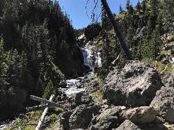
Mystic Falls
Old Faithful, Yellowstone National Park
2.1 miles NW of Old Faithful, Yellowstone National ParkMystic Falls is a 70-foot cascading waterfall on Little Firehole River. The area around the falls is quiet and beautifully forested. Mystic Falls is a lesser known spot in Yellowstone National Park. Even on busy days, the trail leading to the falls is uncrowded.
The trailhead is found on the far side of the Biscuit Basin boardwalk. While walking from the parking lot to the trailhead you will enjoy the views in this brightly colored geyser basin. From the trailhead there are two options for your climb to Mystic Falls. The shorter trail provides a view from below the waterfall, and the longer trail provides a view from above.
The shorter trail is a little over a mile out and back and neighbors Little Firehole River. When you reach Mystic Falls there is a clearly marked path that connects the lower viewing area to the upper viewing area, for those who want to see both spectacular views. The longer trail is a little over two miles. Both trails are mild and easy to walk for beginners.
Mystic Falls is a wonderful trail to escape the busier Yellowstone sights. Located between the Grand Prismatic Spring and Old Faithful, Mystic Falls is a wonderful adventure to add to any Yellowstone trip.
0.1 mi
 Full Listing
Show more
Hike, Swim
Full Listing
Show more
Hike, Swim
Edwards Crossing
Nevada City, California
5.0 miles N of Nevada City, CaliforniaEdwards Crossing is a popular and easily accessible swimming hole on the Yuba River. The swimming hole is named for Edwards Crossing Bridge which can be viewed from there. The river here is up to 20 feet deep in parts and has rock cliffs and forests on either side. The beautiful rock formations and blue water create stunning views for visitors to Edwards crossing.
The depth of the river water and the low rock formations make for great low points for jumping in. Jumpers should be careful to watch water depth and they jump at their own risk.
Edwards crossing also has a sandy beach for visitors to play at and makes for easy access to the water. The beach and swimming hole are a short easy half mile hike from the gravel parking lot near the bridge.
Edwards Crossing is popular with locals due to its accessibility. Summers and weekends can be crowded.
0.2 mi
 Full Listing
Show more
Hike, Swim
Full Listing
Show more
Hike, Swim
Red River George (Jumping Rock)
Gilbertsville, Kentucky
263.8 miles E of Gilbertsville, KentuckyJumping Rock at Red River George is the perfect hidden swimming hole. The swimming hole can be found a short hike from the Red River George Parking Lot. At this point the river calms beside a small sandy beach, and a large rock from whence Jumping Rock got it's name. The water here is deep enough for jumping and diving off the rocks. This picturesque swimming spot is the perfect place to cool off on a hot humid day.
To get to Jumping Rock you will take Sheltowee Connector/Suspension Bridge Trail. This wooded trail is beautiful and continues past the swimming hole for people wanting to continue this scenic hike. The suspension bridge hovers over Red River and is a unique addition to this natural swimming hole.
6.1 mi
 Full Listing
Show more
Hike, Swim
Full Listing
Show more
Hike, Swim
Rip Rap Hollow
Crozet, Virginia
8.3 miles NW of Crozet, VirginiaRip Rap Hollow is a secluded swimming hole that makes for a great stop along the 10 mile loop hike in Shenandoah Valley. This is a difficult hike, but for those up to the challenge it provides incredible panoramic views of the Shenandoah Valley. Along this hike hikers can also enjoy a waterfall view and views of the famous Chimney Rock.
Hikers should park in the Rip Rap Hollow Parking lot and start the loop on Appalachian Trail. For hikers who want to take the ten mile hike over a couple of days, camping is allowed in a couple of primitive camping spots along the trail. These campsites have no amenities and should be kept in their natural state by campers.
The Rip Rap Hollow swimming hole is a section of river that slows and widens into a 50 foot swimming hole. This mountain fed spring is cold and clear and makes for a beautiful spot to cool off after a long hike.
Bathing suits: May be optional depending on solitude or crowd
1.1 mi
 Full Listing
Show more
Camp, Canoe, Cave, Hike, Mountain Bike
Full Listing
Show more
Camp, Canoe, Cave, Hike, Mountain Bike
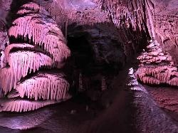
Lewis & Clark Caverns
Whitehall, Montana
10.9 miles E of Whitehall, MontanaThe Lewis & Clark Caverns State Park encompasses 3,015 acres that you can explore by foot, on a bike, in a canoe or in a tent.
The most famous feature of the park is the Lewis & Clark Caverns themselves. The caverns can be accessed via guided tour from May 1st to September 30th each year. The guided tour is well lit and allows visitors to witness a variety of colorful formations in several different rooms. Even in the heat of the summer months the cave remains a cool, humid 48 degrees Fahrenheit.
The cave entrance and exit are at a higher elevation than the visitor center. This gives visitors a short hike to take. The hike is a little over one mile.
Tour tickets can be purchased at the visitor’s center and cost $10 for adults, $5 for children 6 to 11 and are free for children under 5. Children enjoy the adventure of visiting these caverns, especially the tour’s famous Beaver Slide and occasional bat sightings.
Though these caverns are the most famous park feature, the Lewis & Clark Caverns State Park offers many other activities to visitors. There are miles of trails accessible to hikers and mountain bikers from several points on Lewis and Clark Cavern Park Road. For those with a hankering to fish there are several natural fishing spots. Fishing is allowed year-round.
The State Park also has a large campground. The campground’s 40 campsites, 3 cabins and tipi can be reserved online and are available year-round.
Whatever your chosen activity, you will be enchanted by the Lewis & Clark Caverns State Park.
1.2 mi
 Full Listing
Show more
Hike, Swim
Full Listing
Show more
Hike, Swim
Seven Falls and Three Pools
Santa Barbara, California
3.7 miles N of Santa Barbara, CaliforniaSeven Falls and Three Pools is one of the classic front-country adventures above Santa Barbara, California — a rewarding hike up a wooded canyon to a chain of waterfalls and clear swimming holes on Mission Creek, in the foothills of the Santa Ynez Mountains. It's a beloved local escape that trades the beach crowds for a secluded creek canyon, and on a warm day the cool pools at the top are a genuine reward.
The outing is a roughly 4-mile round trip, steep and moderately difficult, with some scrambling on slick rock — so it's best for hikers with a bit of experience and good footwear. The route begins on the Inspiration Point Trail; where it meets Mission Creek, you leave the main path and follow the creek upstream. Boulder-hop and scramble your way up the drainage and you'll pass a series of pretty cascades — the “seven falls” — tucked into the wooded canyon, each a little more secluded than the last.
Keep going, and the payoff is the Three Pools: a set of deep, clear, waterfall-fed swimming holes carved into the sculpted sandstone higher up the creek. This upper stretch is the steepest and trickiest part, but the pools are worth it — cool and refreshing year-round, deep enough for a jump or a plunge when levels are up, and complete with a natural rock waterslide that's a local favorite. The smooth rock formations and quiet woods make it feel a world away from the city just below.
Timing and safety matter here. The falls and pools are fed by Mission Creek, which runs its fullest in spring after winter rains — that's when the water is deepest and the slide and jumps are best. By late summer and in drought years the creek can drop low or dry up, so check recent conditions. As with any rocky canyon swimming spot, the wet rock is slippery, so watch your footing, always check depth before jumping, and be cautious after rain when the creek can run fast.
The hike is part of Santa Barbara's beloved front-country trail network in the Los Padres National Forest foothills, so it pairs naturally with other nearby classics like the ridge views from Inspiration Point or the sandstone of Lizard's Mouth. It's remarkable how quickly the canyon delivers you from the edge of town into wild, quiet country.
Come prepared: wear grippy shoes that can get wet, carry plenty of water (there's none safe to drink on the trail), and get an early start on hot days, since much of the lower trail is exposed. Watch for poison oak along the creek, keep an eye on kids around the pools, and pack out everything you bring to protect this well-loved canyon. For a steep, scenic hike ending in cool mountain pools, Seven Falls and Three Pools is a Santa Barbara classic.
×


