


Chelan Falls Park
Chelan Falls, Washington

| GPS: |
47°47'59.3"N 119°59'2.2"W Maps | Directions |
| State: | Washington |
Hike, Kayak, and Swim
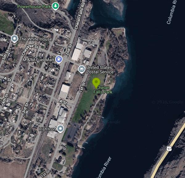
Chelan Falls Park is the Chelan County PUD's 33-acre day-use park on the Columbia River, in the little community of Chelan Falls at the bottom of the hill from Chelan. Like the other PUD parks on the river it is free, well kept and built around the water: a roped swim area in the middle of the park along a concrete retaining wall, a two-lane boat launch with two docks that allow three hours of moorage, and a big lawn with shade trees between them. The Columbia here is the Lake Entiat pool behind Rocky Reach Dam, so the water is slow and, by midsummer, warmer than you would expect of the Columbia, though it is still a big river with cold pockets. There are no lifeguards; the PUD keeps loaner life jackets at the launch.
The park has two restroom buildings with showers, a covered picnic shelter with a sink and power that reserves through the PUD at 509-661-4551, a playground, tennis and pickleball courts, ball fields, four horseshoe pits, and both grass and sand volleyball courts. Hours are 7 a.m. to dusk year round. The address is 555 First Street, Chelan Falls.
Chelan Falls is where the Chelan River ends. The river drops 401 feet in 4.1 miles from Lake Chelan to the Columbia, and since 1927 nearly all of that water has gone through a tunnel to the PUD's Lake Chelan Hydroelectric powerhouse, a National Register building just upstream of the park. The bypassed gorge above town, which was the falls that named the place, now gets scheduled whitewater releases a few days each summer that draw expert kayakers, and the PUD's smaller Powerhouse Park across the river mouth is the spot to watch salmon jump in the fall. The Columbia below the powerhouse is one of the region's better summer salmon fisheries, and on August mornings the launch is busy with boats trolling the Chelan Falls bar.
The town of Chelan Falls is a few blocks of houses and orchards with a post office and a tavern, census population about 340. Chelan, four miles up the hill, has groceries, lodging and the state park beaches on the big lake. The park is a mile off US 97 at the Beebe Bridge turnoff, and Beebe Bridge Park, another PUD park with camping, is directly across the river on the east bank. The PUD posts current river flows and water temperatures on its website, which is worth a look in June when snowmelt keeps the Columbia cold and high; by late July the flow settles and the swim area is at its best.
More Information
Be courteous, informed, and prepared. Read trailhead guidelines, stay on the trail, and don't feed the wildlife.
Read More
- Plan Ahead and Prepare
- Travel & camp on durable surfaces
- Dispose of waste properly
- Leave what you find
- Minimize campfire impacts
- Respect wildlife
- Be considerate of other visitors
Directions
From Chelan Falls, Washington
- Head southeast on Chestnut St toward 1st St (443 ft)
- Chestnut St turns right and becomes 1st St (0.2 mi)
- Turn left (98 ft)
- Turn right (472 ft)
- Turn left (85 ft)
- Turn rightDestination will be on the left(0.2 mi)
 The Columbia River at Chelan Falls from the air, with Lake Chelan beyond courtesy of Doc Searls from Santa Barbara, USA↗ (CC BY 2.0↗)

 The Lake Chelan Hydroelectric powerhouse at Chelan Falls courtesy of Jon Roanhaus↗ (CC BY-SA 3.0↗)

 Beebe Bridge over the Columbia near the park courtesy of SounderBruce↗ (CC BY-SA 4.0↗)

 Chelan Falls about 1900, before the powerhouse added by freearenas (No restrictions)

 The Chelan River canyon in 1900 added by freearenas (No restrictions)

Other Swimming Holes, Hiking Trails, and Kayaking Areas Nearby
Douglas Creek
Palisades, Washington
23.9 miles SSwim near Palisades, Washington
Swim 
Steamboat Rock State Park Swim Beach
Electric City, Washington
40.2 miles ESandy roped swim beach on Banks Lake below the 800-foot basalt butte of Steamboat Rock State Park, 14 miles south of Grand Coulee Dam in the Washington desert.
Camp, Hike, Kayak, Mountain Bike, Swim 
Rock Island
Leavenworth, Washington
45.5 miles WSwim near Leavenworth, Washington
Swim


