


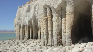
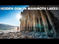
Crowley Lake Stone Columns
Mammoth Lakes, California
| Address: | J75J+29 Crowley Lake, CA, USA |
| GPS: |
37°36'27.3"N 118°43'8.5"W Maps | Directions |
| State: | California |
| Trails/Routes: | 0.4 mi |
Hike
Nestled in the picturesque landscape of California's Eastern Sierra region lies Crowley Lake, a reservoir with a captivating secret beneath its surface – the Crowley Lake Stone Columns. This geological wonder has intrigued scientists, geologists, and curious minds alike, offering a fascinating glimpse into the Earth's ancient history.
Formation:
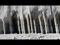
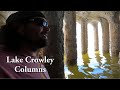
The Crowley Lake Stone Columns are an extraordinary formation of cylindrical columns, resembling ancient pillars or towering stone structures. These columns, standing at an average height of 20 feet, were not crafted by human hands, but rather, they are the result of a natural process known as tufa formation.
Tufa is a type of limestone that forms when calcium-rich spring water mixes with alkaline lake water. In the case of Crowley Lake, the interaction of these two distinct water sources created a chemical reaction that led to the precipitation of calcium carbonate. Over thousands of years, this process resulted in the gradual buildup of the stone columns, transforming the lakebed into a surreal landscape.
Geological Significance:
The Crowley Lake Stone Columns provide a unique insight into the geological history of the region. The tufa formation began approximately 600,000 years ago during the Pleistocene Epoch, a period characterized by extensive glaciation. As glaciers receded, they left behind vast freshwater lakes, such as Crowley Lake, which served as a canvas for the intricate dance of chemical processes that birthed the stone columns.
The water chemistry of Crowley Lake played a crucial role in shaping the characteristics of the columns. The lake's alkalinity, combined with the influx of calcium-rich spring water, created an ideal environment for tufa formation. As the columns grew, they captured the essence of the lake's geological evolution, preserving a snapshot of Earth's history in their limestone structure.
Ecological Importance:
Beyond their aesthetic appeal and geological significance, the Crowley Lake Stone Columns also play a vital role in the local ecosystem. Tufa formations create habitats for various aquatic organisms, providing shelter and breeding grounds for fish and invertebrates. The presence of these structures enhances biodiversity in the lake, contributing to the delicate balance of the ecosystem.
Preservation and Visitor Experience:
Recognizing the ecological importance and unique beauty of the Crowley Lake Stone Columns, conservation efforts have been put in place to protect this natural wonder. Visitors can witness the columns from designated viewpoints and learn about their formation through educational displays. Respecting posted guidelines ensures the preservation of this geological marvel for future generations to appreciate.
Conclusion:
The Crowley Lake Stone Columns stand as a testament to the intricate dance between geological processes and environmental conditions. Their formation over thousands of years mirrors the ever-changing narrative of Earth's history. As visitors marvel at the surreal beauty of these natural pillars, they are granted a unique opportunity to connect with the ancient forces that have shaped our planet. The Crowley Lake Stone Columns are not just a sight to behold; they are a tangible link to the Earth's captivating past.
More Information
Be courteous, informed, and prepared. Read trailhead guidelines, stay on the trail, and don't feed the wildlife.
Read More- Plan Ahead and Prepare
- Travel & camp on durable surfaces
- Dispose of waste properly
- Leave what you find
- Minimize campfire impacts
- Respect wildlife
- Be considerate of other visitors
Directions
From Mammoth Lakes, California
- Head west (276 ft)
- Turn left toward CA-203 E/
Main St (240 ft) - Turn left onto CA-203 E/
Main St Continue to follow CA-203 E(3.1 mi) - Turn right to merge onto US-395 S toward Bishop (14.9 mi)
- Turn left onto Owens Gorge Rd (3.7 mi)
- Turn right to stay on Owens Gorge Rd (0.3 mi)
- Turn left to stay on Owens Gorge Rd (0.3 mi)
- Sharp left (1.2 mi)
- Turn left at Forest Rd 4S45 (174 ft)
- Turn right (0.5 mi)
- Continue straight (0.2 mi)


Trails
Distance ?
0.4 miles Round TripElevation Gain ?
-154 feetReal Ascent ?
0 feetReal Descent ?
154 feetAvg Grade (-9°)
-16%Grade (-19° to -1°)
-35% to -3%Elevation differences are scaled for emphasis. While the numbers are accurate, the cut-away shown here is not to scale.
Other Hiking Trails Nearby

Crowley Lake
Mammoth Lakes, California
1.2 miles NWNestled in the picturesque landscape near Benton, California, Crowley Lake stands as a hidden gem, known not only for its breathtaking natural beauty but also for the intriguing geological formations...
Hike, Swim
Crystal Lake
Mammoth Lakes, California
16.0 miles WUnlike many hikes in the Sierra's, Crystal lake can be done as a day hike and as the perfect way to get away for a bit. As hikers make their way to the lake, they will see the monolith Crystal...
Camp, Hike
Standish Hickey Area
Lakeshore, California
25.5 miles SWStandish-Hickey is an inland river canyon that runs along Highway 101 just 180 miles from San Fransisco. It's home to a two-mile stretch of the south fork on Eel River, where many...
Backpack, Camp, Hike, Kayak, Swim 4.0 mi
Mono Pass
Yosemite Valley, CA
35.5 miles NWAt an elevation of 10,600 feet, the hike through Mono Pass is an 8 mile journey that takes you across the High Sierras, through several meadows, and stops at a few different lakes along the...
Hike, Swim 3.6 mi
Lyell Canyon
Wawona, California
36.4 miles NWLyell Canyon is a breezy, 8 mile hike through the Tuloumne Meadows of Yosemite. While it is a little bit of a longer hike, the total elevation gain is about 200 feet, making it pretty flat and...
Hike 1.8 mi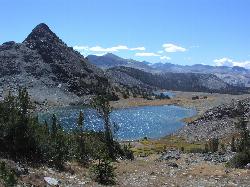
Gaylor Lakes
Yosemite Valley, CA
36.6 miles NWGaylor Lakes is one of Yosemite's most underrated hikes. It's a 2 mile trail with views the entire way. At various points along the trail, you can see Dana Meadows and the mountains...
Hike, Swim
Tuolumne Meadows
Tuolumne County, California
38.9 miles NWA beautiful alpine meadow found in the upper Sierra Nevada Mountains. Open during the summer, this meadow offers excellent views of nearby granite domes and mountains. There is a roadway through...
Camp, Hike 4.0 mi
Saddlebag Lake
Lee Vining, California
39.0 miles NWA man-made lake found in the Inyo forest, resting at about 10,008 feet above sea level, Saddlebag Lake is located just outside the Tioga Pass entrance to Yosemite National Park. This lake has some of...
Camp, Canoe, Hike 0.8-4.1 mi
Dog Lake and Lembert Dome
Yosemite Valley, CA
39.1 miles NWThe hike to Dog Lake is often paired with the hike to Lembert Dome, because the two are so close in proximity. Each hike by itself is 2.8 miles round trip, but Lembert Dome has an elevation gain of...
Hike, Swim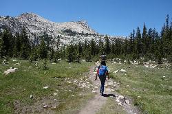
Elizabeth Lake
Wawona, California
39.2 miles NWElizabeth Lake is a gorgeous lake tucked underneath the High Sierras in Yosemite. It's about a 4.8 mile hike to reach it, with an elevation gain of 1000 feet. Even though it's not super long,...
Hike, Swim 1.1 mi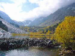
Lundy Canyon
Bridgeport, California
41.2 miles NWIn just one 3 mile hike, Lundy Canyon provides views of waterfalls, meadows, mountains, and if you're up for it, a trip to the Twenty Lakes Basin. There is much to take in even after going...
Hike 0.9-3.2 mi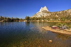
Cathedral Lakes
Wawona, California
41.8 miles NWOne of the busiest trails in the Tuloumne Meadows area, the hike to Cathedral Lakes is a gorgeous 7 mile walk to the perfect place to rest and recuperate. While there are several High Sierra...
Hike, Swim
Glen Aulin
Glen Aulin, California
43.5 miles NWThis trail is a popular route to take in the Yosemite High Country because it is a good introductory hike into the backcountry. At the end of the hike there are several waterfalls as well as a...
Backpack, Camp, Hike, Swim 6.0 mi
Glen Aulin
Wawona, California
43.5 miles NWThis is an 11 mile hike along the Tuolumne River to Glen Aulin. There is a view to take in at every turn on this hike, whether it's the Tuolumne River, Tuolumne Fall, Soda Springs,...
Backpack, Camp, Hike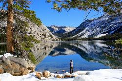
Tenaya Lake
Yosemite Valley, Yosemite National Park
43.5 miles WTenaya Lake is one of the most visited destinations in Yosemite National Park. The lake is easily accessed by Highway 120/Tioga Pass road which runs along the north shore of the lake. On the east...
Canoe, Hike, Kayak, Swim 1.9 mi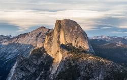
Half Dome
Yosemite Valley, Yosemite National Park
44.4 miles WHalf Dome is the most popular and difficult hike in Yosemite Valley. The trail is about 14 miles long with an elevation gain of 4800 feet. There are cables to help you scale up to the summit once you...
Hike 1.2-1.6 mi
May Lake
Yosemite Valley, Yosemite National Park
45.4 miles WMay lake is a relatively small lake that rests at the base of Mt. Hoffman in Yosemite National Park. One of the park's most scenic lakes, May lake not only gets up close and personal with...
Hike, Swim 5.5 mi
Ostrander Lake
Wawona, California
45.5 miles WOstrander Lake is a long, 11.4 mile hike just behind Sentinel Dome. Unlike most of Yosemite's summer hikes, the trail to Ostrander Lake is open during the winter for people to ski through....
Hike, Swim 2.1 mi
Snow Creek Falls
Yosemite Valley, Yosemite National Park
45.9 miles WSnow Creek is one of the more difficult waterfalls to find in the valley, but in the spring and summer months, the elusive waterfall can be seen from the Mirror Lake Trail, a 5 mile loop around...
Backpack, Hike
Mirror Lake
Yosemite Valley, Yosemite National Park
46.4 miles WMirror Lake is a seasonal lake situated in a secluded corner of the beautiful Yosemite Valley. The lake sits at the base of Half Dome and allows a different perspective of the famous monolith....
Backpack, Hike, SwimNearby Campsites

Crowley Lake Campground
Crowley Lake, California
3.6 miles SWNestled amidst the stunning Eastern Sierra region, Crowley Lake BLM Campground near Benton, California, is a hidden gem waiting to be discovered by nature enthusiasts and camping aficionados. With...
Camp
Wild Willy's Hot Spring
Mammoth Lakes, California
4.5 miles NWWild Willy's Hot Springs, also known as Crowley Hot Springs, is a spring located in Long Valley. Long Valley is home to one of the highest concentrations of geothermal surface water in...
Camp, Hot Springs
Crystal Lake
Mammoth Lakes, California
16.0 miles WUnlike many hikes in the Sierra's, Crystal lake can be done as a day hike and as the perfect way to get away for a bit. As hikers make their way to the lake, they will see the monolith Crystal...
Camp, Hike
Standish Hickey Area
Lakeshore, California
25.5 miles SWStandish-Hickey is an inland river canyon that runs along Highway 101 just 180 miles from San Fransisco. It's home to a two-mile stretch of the south fork on Eel River, where many...
Backpack, Camp, Hike, Kayak, Swim
Tuolumne Meadows
Tuolumne County, California
38.9 miles NWA beautiful alpine meadow found in the upper Sierra Nevada Mountains. Open during the summer, this meadow offers excellent views of nearby granite domes and mountains. There is a roadway through...
Camp, Hike 4.0 mi
Saddlebag Lake
Lee Vining, California
39.0 miles NWA man-made lake found in the Inyo forest, resting at about 10,008 feet above sea level, Saddlebag Lake is located just outside the Tioga Pass entrance to Yosemite National Park. This lake has some of...
Camp, Canoe, Hike
Glen Aulin
Glen Aulin, California
43.5 miles NWThis trail is a popular route to take in the Yosemite High Country because it is a good introductory hike into the backcountry. At the end of the hike there are several waterfalls as well as a...
Backpack, Camp, Hike, Swim 6.0 mi
Glen Aulin
Wawona, California
43.5 miles NWThis is an 11 mile hike along the Tuolumne River to Glen Aulin. There is a view to take in at every turn on this hike, whether it's the Tuolumne River, Tuolumne Fall, Soda Springs,...
Backpack, Camp, Hike
Merced River
Yosemite Valley, Yosemite National Park
48.1 miles WThe main fork of Merced River at Yosemite National Park is a perfect place to fish, swim, raft, and even pan for gold. The river circles around the center of Yosemite Valley, and almost every...
Camp, Swim, Whitewater 5.7 mi
Ten Lakes
Tuolumne Meadows, Yosemite National Park
48.2 miles NWA 6.4 mile hike will lead you to three of the Ten Lakes at Ten Lakes Basin. There are three possible trails to take to see this phenomenon. The shortest begins at Yosemite Creek. The other two...
Backpack, Camp, Hike


