


113 Hiking Trails in Idaho
first prev 1 2 3 4 5 6 next lastShowing Hiking Trails in Idaho, USA City, Zip, or Address
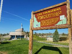
Hell's Half Acre Southbound Rest Stop
Blackfoot, Idaho
8.8 miles NE of Blackfoot, IdahoThis is a well maintained rest area with facilities to keep you happy as you travel through Idaho. This rest stop on Interstate 15 about 15 miles South of Idaho Falls has nice picnic tables and...
Hike
Burns Canyon
Ririe, Idaho
15.3 miles E of Ririe, IdahoHike and Mountain Bike near Ririe, Idaho
Hike, Mountain Bike 1.4 mi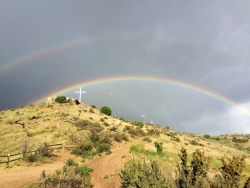
Table Rock
Boise, Idaho
3.0 miles SE of Boise, IdahoTable Rock is located directly above downtown Boise, Idaho and is part of the extreme southwestern portion of the Boise Mountains. It is recognizable by the tall white cross, that lights up. If...
Hike 17.5 mi
Tear Drop Lake
Ashton, Idaho
19.1 miles NE of Ashton, IdahoNestled in the Targhee National Forest just off of Ashton's Fish Creek Road, this tear drop shaped lake is a family adventure waiting to happen. The lake isn't very big but it is teeming with...
Camp, Canoe, Hike, Kayak, Mountain Bike, Swim 1.0-1.3 mi
Lorenzo Bridge
Rexburg, Idaho
7.2 miles SW of Rexburg, IdahoThis is the old site of the Lorenzo Boat Launch, which has moved to the other side of the river a little further downstream. This spot sees very little traffic. There are beautiful, yet...
Airsoft, Hike, Paintball
Mccall Area
McCall, Idaho
10.4 miles NE of McCall, IdahoMcCall is a beautiful resort town located in western Idaho, two hours north of Boise. It's feautures a multitude of activity of activities in both the Winter and Summer months, including:...
Backpack, Camp, Canoe, Cross-country Ski, Hike, Kayak, Mountain Bike, Sled, Snowshoe, Swim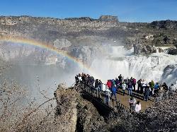
Shoshone Falls Park
Twin Falls, Idaho
3.7 miles NE of Twin Falls, IdahoThe view of Shoshone Falls is beautiful year round but it is simply breathtaking during spring runoff when the water levels are high and they roar so hard you can feel the mist hundreds of feet...
Hike 0.2-9.7 mi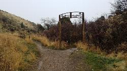
City Creek
Pocatello, Idaho
1.3 miles S of Pocatello, IdahoThe City Creek Management Area (CCMA) Trail System is a vast network of trails maintained by the City of Pocatello. There are trails to go up and others to come down. Most trails come back to the...
Hike, Horseback, Mountain Bike 4.2 mi
Lake Marie
Island Park, Idaho
9.7 miles N of Island Park, IdahoLake Marie sits on the North slope of Mount Jefferson in Fremont County, Idaho. The trail to get there cuts back and forth across the Idaho Montana border 4 times. Much of the trail is fairly flat...
Backpack, Hike 3.8 mi
Kelly Mountain Trail
Ririe, Idaho
8.2 miles E of Ririe, IdahoKelly Canyon Trail is a moderate, uphill trail that can be used by hikers, mountain bikers, and ATV riders. The trail features views of hills, mountains, trees, wildflowers, and some wildlife. Dogs...
Cross-country Ski, Hike, Mountain Bike, Snowshoe
Mesa Falls
Ashton, Idaho
10.0 miles NE of Ashton, IdahoUpper Mesa Falls, aka Big Falls, is an absolutely awesome waterfall on the Henrys Fork of the Snake River. The falls drop 114 ft. and measure 300 ft. across. To get to the falls from the parking lot...
Cross-country Ski, Hike, Kayak 0.6-4.7 mi
Harriman State Park
Island Park, Idaho
8.3 miles SW of Island Park, IdahoHarriman State Park is found 38 miles from Yellowstone along Henry's Fork. This 11,000-acre wildlife refuge is open year round for most activities. In addition to having beautiful scenery and...
Cross-country Ski, Hike, Horseback, Mountain Bike, Snowshoe 0.8 mi
Conant Creek Pegram Truss Railroad Bridge
Ashton, Idaho
5.0 miles SE of Ashton, IdahoAs part of the Rails to Trails project, this old railroad bridge has been transformed into a very safe little viewing experience for the whole family. You can drive right up to the bridge where there...
Hike 0.3-0.6 mi
Bear Gulch
Ashton, Idaho
9.7 miles NE of Ashton, IdahoBear Gulch is an abandoned ski hill out of operation since 1969. While the vegetation is beginning to take over, there's still some great sledding to be had. It's just far enough into the...
Camp, Cross-country Ski, Hike, Sled
Big Springs
Island Park, Idaho
7.6 miles NE of Island Park, IdahoThere's also a great little walking trail along the river with placards that tell about the ecosystem and history of the area. There's about a 1/2 mile that's paved and then a 1/2 mile...
Camp, Hike 5.6-8.3 mi
Palisades Creek Trail / Lakes and Waterfall Canyon
Irwin, Idaho
4.4 miles E of Irwin, IdahoPalisades Creek Trail is located about 50 miles southeast of Idaho Falls and about 60 miles west of Jackson Hole WY in Swan Valley Idaho. The four mile hike up to lower Palisades Lake or the 6.2 mile...
Backpack, Camp, Hike, Horseback, Mountain Bike 0.1 mi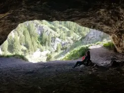
40 Horse Cave
Firth, Idaho
11.9 miles E of Firth, IdahoThe naming of the cave comes from a story of two men who were caught in a bad storm. Upon hiking, these two guys were able to find the cave. One of them commented to the other, "This cave could...
Cave, Hike
Fall Creek Falls
Swan Valley, Idaho
2.1 miles SW of Swan Valley, IdahoFalls Campground is located next to the Snake River near beautiful Swan Valley, only 45 miles east of Idaho Falls, Idaho. Mixed growth cottonwood trees provide partial shade, and grassy meadows with...
Camp, Cave, Hike, Kayak, Swim 0.5-3.5 mi
Webster's Dam
Ririe, Idaho
9.8 miles NE of Ririe, IdahoAlso known as Manmade Falls or the Woodmansee Dam, Webster Dam is an abandoned dam located deep in Moody Creek canyon, the dam was abandoned when sediment built up behind the dam which then...
Camp, Hike, Mountain Bike 0.1-0.5 mi
Eagle Park
Rexburg, Idaho
0.9 miles N of Rexburg, IdahoEagle Park is a little urban oasis. Once you drive in to this cottonwood forest along the river, you may forget that you're still inside Rexburg city limits. You can camp, picnic, throw rocks in...
Camp, Hike, Mountain Bike, Sled


