


Lorenzo Bridge
Rexburg, Idaho

| Address: | 3987 W 6800 S, Rexburg, ID 83440, USA |
| GPS: |
43°43'58.9"N 111°51'58.8"W Maps | Directions |
| State: | Idaho |
| Field Type: | Public Land |
| Trails/Routes: | 1.0-1.3 mi |
Fall Colors
Airsoft, Hike, and Paintball
This is the old site of the Lorenzo Boat Launch, which has moved to the other side of the river a little further downstream. This spot sees very little traffic. There are beautiful, yet primitive trails along the river and a well hidden lake. There is a lot of marsh ground and the falls colors are amazing. The trails drawn on the map here are partial. They can be followed further and likely connect to form a loop. If you know the rest of the trail, please let us know.
Paintball Field
Great natural boundaries; There's a river on one side and a dry bed on the other. On one end, it drops down and then becomes sparse. On the other end, there's a fence with nice walk-in gates. There's a dry creek bed that runs through it to one side that gives it a good amount of variety. There's quite a bit of undergrowth and even a couple of nice big man-made stick barriers toward the middle of the field.
When the construction started on the Thornton exit, they blocked off the parking lot on the West side. They built a new parking lot on the East side across the tracks and a trail underneath the bridge and road. You have to haul your stuff now but there is still access to an awesome field.
More Information
Add ResourceBe courteous, informed, and prepared. Read trailhead guidelines, stay on the trail, and don't feed the wildlife.
Read More- Plan Ahead and Prepare
- Travel & camp on durable surfaces
- Dispose of waste properly
- Leave what you find
- Minimize campfire impacts
- Respect wildlife
- Be considerate of other visitors
Directions
From Rexburg, Idaho
- Head south on S 3rd W toward W 2nd S (0.4 mi)
- Turn right onto W 4th S (0.3 mi)
- Continue onto S Yellowstone HwyPass by McDonald's (on the left in 1.1 mi)(2.0 mi)
- Turn left onto S 2000 W/
Archer Rd (4.2 mi) - Turn right onto W 6800 SDestination will be on the left(2.4 mi)
From either parking area, follow the trail underneath the highway and around to the trails and paintball field. If you park in the space just off the highway, you'll have to jump down a 3-4 foot wall to the trail (not illegal. see photos). The parking lot across the tracks is much nicer but does add about 100yds to your walk.
freearenas
12/19/17 2:14 pmendovereric
10/11/18 2:12 pmpyromaniac777
10/20/15 10:25 pmfreearenas
12/19/17 2:15 pm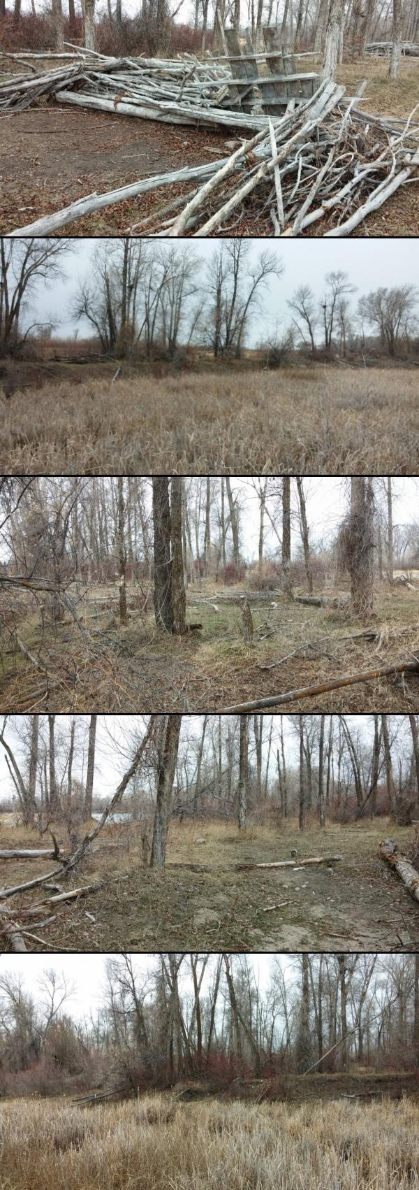 From one bunker to another (toward middle of field) courtesy of endovereric↗
 courtesy of endovereric↗")
 Drop-down from closer parking courtesy of endovereric↗
 Trail under the road courtesy of endovereric↗
 One of the main midfield bunkers courtesy of endovereric↗
 Paintball field courtesy of endovereric↗
 One of the 2 main midfield bunkers courtesy of endovereric↗
 Northern trail courtesy of endovereric↗
 One of the 2 main midfield bunkers courtesy of endovereric↗
 River from the trail courtesy of endovereric↗
 Paintball field courtesy of endovereric↗
 Marsh trail beyond paintball field courtesy of endovereric↗
 Paintball field courtesy of endovereric↗

Other Paintball Fields, Airsoft Fields, and Hiking Trails Nearby

Lorenzo Boat Ramp
Rigby, Idaho
0.7 miles WHike and Kayak near Rigby, Idaho
Hike, Kayak
Ririe River Island (AKA Twin Bridges)
Rexburg, Idaho
6.4 miles SEA natural paintball island accessible by rock-hopping across the creek — rock bunkers, water-filled trenches, and a fence perimeter just north of Ririe Reservoir.
Airsoft, Paintball 0.6-2.0 mi
North Menan Butte ('R' Mountain)
Menan, Idaho
7.2 miles NWA volcanic butte locals call R Mountain, with a paved trailhead, chain handrails near the top, informational signs at the rim, and views of Rexburg and the Snake River.
Camp, Cave, Hike 0.2-0.5 mi
Eagle Park
Rexburg, Idaho
7.9 miles NEA cottonwood forest park inside Rexburg city limits with campsites, fishing, a dog park, mountain biking on easy and moderate loops, and rock-throwing by the river.
Camp, Hike, Mountain Bike, Sled 0.1-1.3 mi
Hidden Valley Trails
Rexburg, Idaho
8.0 miles NEA well-signed network of downhill singletrack flows around the edges of Rexburg, with trails like Flow State, Drop Zone, and Lil' Sendy for every ability level.
Hike, Mountain Bike 0.3-0.6 mi
Cress Creek Nature Trail
Rexburg, Idaho
9.0 miles SEA 1.25-mile self-guided nature trail along the South Fork of the Snake River through sagebrush, juniper slopes, and lush creekside habitat — with an overlook trail, caves near the rim, and moose sightings.
Hike
Rattle Rock / The Gauntlet
Menan, Idaho
9.2 miles NWA collapsed lava tube gauntlet with 20-foot climbable rock walls, manmade tunnels, caves, and turret vantage points — an unconventional outdoor paintball arena with bouldering thrown in (watch for rattlesnakes).
Airsoft, Paintball 0.8-1.3 mi
Warm Slough Campground
Rexburg, Idaho
9.5 miles NA popular river campground with two boat ramps and an easy, slow-moving inner tube float — the take-out is 1,000 feet from the put-in, making multiple runs a breeze.
Airsoft, Camp, Canoe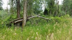
On the banks by Heise
Ririe, Idaho
10.4 miles SEOn the banks of the river near Heise. Plenty of trees and ground cover.
Airsoft, Paintball
Herbert Idaho Ghost Town
Ririe, Idaho
10.5 miles ECLOSED. Private property marked NO TRESPASSING. The quiet ghost of a farming and mining community that once housed 150 people — Herbert, Idaho faded with the automobile, and the old house was lost to vandals around 2017.
Hike
Lava Hill
Menan, Idaho
11.1 miles NWCollapsed lava tubes and sagebrush ridgelines create a natural paintball labyrinth right off the highway — just watch for rattlesnakes before setting up.
Airsoft, Paintball 0.5-3.5 mi
Webster's Dam
Ririe, Idaho
13.6 miles EAn abandoned dam in Moody Creek canyon where sediment split the stream into two beautiful 15-foot waterfalls — stunning in spring runoff and blazing with fall colors.
Camp, Hike, Mountain Bike 3.8 mi
Stinking Springs
Ririe, Idaho
13.9 miles SEAn ATV and dirt bike trail that doubles as a mountain bike gem — progressively bermed switchbacks, rock rolls, and gardens lead to connections with Kelly Canyon and the broader Big Hole range.
Hike, Mountain Bike 2.1-2.3 mi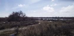
Market Lake Wildlife Management Area
Roberts, Idaho
14.0 miles WA wildlife management area teeming with waterfowl — ibis colonies, ducks, geese, herons, eagles, hawks, and owls — plus mule deer, white-tailed deer, and a small moose population near Roberts, Idaho.
Hike, Horseback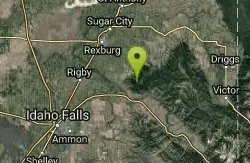
Bighole Mountains / Moody
Ririe, Idaho
14.1 miles EWooded fields divided by two merging roads and a natural elevation change create a versatile unofficial airsoft and paintball area in the Big Hole Mountains.
Airsoft, Paintball 3.8 mi
Kelly Mountain Trail
Ririe, Idaho
14.4 miles SEA moderate uphill trail open to hikers, mountain bikers, and ATVs, winding through hills with wildflower and mountain views — dogs welcome on leash.
Cross-country Ski, Hike, Mountain Bike, Snowshoe 1.7 mi
Buckskin Morgan Ridge
Ririe, Idaho
14.9 miles SEA punchy climb to Buckskin Morgan Ridge pays off with twisty singletrack descents through roots, loose rock, and rolling hills above the Snake River Plain.
Hike, Mountain Bike 1.1 mi
Hidden Vista / Pine Loop
Ririe, Idaho
14.9 miles SEA short singletrack trail to a canyon overlook with Snake River views — then a detour east for fun climbs, turns, rocks, and jumps on the way back to the Buckskin Morgan parking lot.
Hike, Mountain Bike
Poison Flats
Ririe, Idaho
15.2 miles SEHike near Ririe, Idaho
Hike 0.6-2.2 mi
Fish Creek Area
Ririe, Idaho
15.9 miles EThe Big Hole Mountains' Fish Creek trail network serves up singletrack climbs, floater jumps, rock gardens, and fast Fishbone descents accessed from Ririe or Rexburg.
Hike, Mountain BikeNearby Campsites

Jefferson County Lake (AKA Rigby Lake)
Rigby, Idaho
2.9 miles SWSandy beaches, two floating docks with a slide, volleyball, playgrounds, and a safe swim zone — Jefferson County Lake is eastern Idaho's go-to summer swimming spot.
Camp, Canoe, Dive, Kayak, Sled, Swim
Twin Bridges Park
Rexburg, Idaho
6.5 miles SEA 27-acre Snake River park between two bridges near Rexburg with shaded campsites, fire pits, pavilions, a playground, and BLM ground for hiking and hunting on three sides.
Camp, Canoe
Beaver Dick Park
Rexburg, Idaho
6.7 miles NA 9.5-acre Snake River park near Rexburg with fire pits, pavilions, fishing, boating, swimming, and a rich history tied to legendary frontiersman Beaver Dick Leigh.
Camp, Canoe, Disc Golf, Swim 0.6-2.0 mi
North Menan Butte ('R' Mountain)
Menan, Idaho
7.2 miles NWA volcanic butte locals call R Mountain, with a paved trailhead, chain handrails near the top, informational signs at the rim, and views of Rexburg and the Snake River.
Camp, Cave, Hike 0.2-0.5 mi
Eagle Park
Rexburg, Idaho
7.9 miles NEA cottonwood forest park inside Rexburg city limits with campsites, fishing, a dog park, mountain biking on easy and moderate loops, and rock-throwing by the river.
Camp, Hike, Mountain Bike, Sled 0.8-1.3 mi
Warm Slough Campground
Rexburg, Idaho
9.5 miles NA popular river campground with two boat ramps and an easy, slow-moving inner tube float — the take-out is 1,000 feet from the put-in, making multiple runs a breeze.
Airsoft, Camp, Canoe
Paramount Wall / Blanche Rock
Ririe, Idaho
12.5 miles SEA sport climbing wall above the road near Ririe with great exposure, afternoon shade, and well-loved 5.9–5.10 lines — most routes work with a 50-meter rope, established by Chuck Oddette and crew.
Camp, Horseback, Rock Climb
Kelly Island Campground
Ririe, Idaho
12.7 miles SEA BLM campground with 14 family sites and 1 group site for RVs or tents, open May through September — vault toilets, pets welcome, and rates from $5–$20 per night.
Camp 0.5-3.5 mi
Webster's Dam
Ririe, Idaho
13.6 miles EAn abandoned dam in Moody Creek canyon where sediment split the stream into two beautiful 15-foot waterfalls — stunning in spring runoff and blazing with fall colors.
Camp, Hike, Mountain Bike
Big Hole Dispersed Campsites
Ririe, Idaho
13.6 miles EA network of dispersed campsites with fire rings in the Big Hole mountains above Kelly Canyon — first come, first served, no reservations, and Leave No Trace principles are essential.
Camp
Table Rock Campground
Ririe, Idaho
15.6 miles SEA campground in Caribou-Targhee National Forest — part of a 3-million-acre stretch from Montana to the Utah and Wyoming borders — with access to the Curlew National Grassland.
Camp
Wolf Flats Recreation Area
Ririe, Idaho
15.8 miles SEWolf Flats is a completely free, dispersed, undeveloped camping area with 25 locations to camp. Some areas are large enough to accommodate groups of 50 people.
Camp
Moody Meadows
Driggs, Idaho
20.4 miles EGood place for kids, they can ride bikes in the meadow, play in the stream, and camping is off of the road. Hiking, motorbiking, and horseback riding trails are abundant in the area.
Camp
Sealander Park
Idaho Falls, Idaho
25.3 miles SWA peaceful 15-acre park steeped in Idaho homesteader history — listed on the National Register of Historic Places, Sealander Park is available to reserve for picnics, reunions, weddings, and retreats.
Camp
Fall Creek Falls
Swan Valley, Idaho
31.8 miles SEA shaded Snake River campground near Swan Valley with abundant wildlife, great trout fishing, and Fall Creek Falls a quarter-mile away.
Camp, Cave, Hike, Kayak, Swim
Falls Campground
Victor, Idaho
32.7 miles SEA Snake River campground near Swan Valley with cottonwood shade, abundant wildlife — eagles, osprey, moose, and deer — and Fall Creek Falls just a quarter mile away; Palisades Reservoir is 20 miles out.
Camp
Firth River Bottoms
Firth, Idaho
33.8 miles SWA community riverside park in Firth with horseback riding, picnicking, fishing, and baseball — something for the whole family along the river bottoms.
Camp, Canoe, Hike
Pine Creek Campground
Victor, Idaho
34.8 miles EThe Pine Creek Campground has 10 single units and has restrooms.
Camp
Pine Butte / The Caldera
St. Anthony, Idaho
36.8 miles NAn old volcano in the Idaho desert that feels like stepping into a mountain forest — pine-covered hillsides, a meadow ringed by aspen and boulders, and a quarter-mile easy trail to the caldera floor.
Camp, Hike, Horseback
Warm River Campground
Ashton, Idaho
38.5 miles NESlow-moving warm water and willow-lined banks make this campground a perfect spot for tubing, trout fishing, and peaceful mountain biking at 5,200 ft elevation.
Camp


