


70 Hiking Trails near Buckskin Morgan Ridge
first prev 1 2 3 4 next lastShowing Hiking Trails within 50 miles Distance miles of Forest Road 218, Ririe, ID 83443, USA City, Zip, or Address

Bear Gulch
Ashton, Idaho
38.3 miles NEBear Gulch is an abandoned ski hill out of operation since 1969. While the vegetation is beginning to take over, there's still some great sledding to be had. It's just far enough into the...
Camp, Cross-country Ski, Hike, Sled
17 Mile Cave
Idaho Falls, Idaho
38.7 miles WSeventeen Mile Cave is a lava tube, a cave created by the pocket in which lava used to flow and was left empty when the volcano became inactive. The cave gets its name from its location, just 17...
Cave, Hike
Sheep Falls on Henry's Fork
Island Park, Idaho
39.6 miles NSheep Falls cascades approximately 25' through a narrow basalt chute on the North Fork of the Snake River near Island Park, Idaho. Compared to nearby Lower and Upper Mesa Falls, that height may...
Hike
Mesa Falls
Ashton, Idaho
39.9 miles NUpper Mesa Falls, aka Big Falls, is an absolutely awesome waterfall on the Henrys Fork of the Snake River. The falls drop 114 ft. and measure 300 ft. across. To get to the falls from the parking lot...
Cross-country Ski, Hike, Kayak 4.9 mi
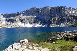
Amphitheater Lake
Alta, Wyoming
41.1 miles EBackpack and Hike near Alta, Wyoming
Backpack, Hike 1.3-4.3 mi
Phelps Lake
Jackson, Wyoming
41.1 miles EThe Phelps Lake trail, located in Teton National Park, Wyoming, is in one of the most scenic locations of the park. Usually overshadowed by nearby Jenny Lake, it can often be missed by visitors of...
Backpack, Camp, Dive, Hike, Swim
Jumping Rock at Phelp's Lake
Jackson, Wyoming
41.1 miles EJust below Teton's Death Canyon, on the eastern shore of Phelp's Lake is a 20 foot boulder sitting all by itself above deep water. It's almost if God said, "Those hikers will need a...
Dive, Hike, Swim
Hell's Half Acre Southbound Rest Stop
Blackfoot, Idaho
41.2 miles SWThis is a well maintained rest area with facilities to keep you happy as you travel through Idaho. This rest stop on Interstate 15 about 15 miles South of Idaho Falls has nice picnic tables and...
Hike
Hell's Half Acre Northbound Rest Stop
Blackfoot, Idaho
41.3 miles SWThis is a well maintained rest area with facilities to keep you happy as you travel through Idaho. This rest stop on Interstate 15 about 9 miles north of Blackfoot Idaho has nice picnic tables and...
Hike 0.9 mi
Hell's Half Acre Lava Walk
Blackfoot, Idaho
42.8 miles WThe Lava Trails traverse the desert of the Snake River Plain through contorted landscapes created from multiple lava flows. These Hawaiian-type lava flows are associated with the stretching of the...
Hike
Mt. Moran
Alta, Wyoming
42.9 miles EMount Moran (12,610 feet (3,840 m)) is a mountain in Grand Teton National Park of western Wyoming, USA. The mountain is named for Thomas Moran, an American western frontier landscape artist....
Hike 0.3-5.1 mi
Jenny Lake Trail
Jackson Hole, Wyoming
43.0 miles EOne of the most popular trails to visit in Grand Teton is the Jenny Lake Trail. The Jenny Lake Trail, located near Moose, Wyoming, is an easy trail that loops around the lake. Along with the sheer...
Hike 3.9-14.4 mi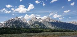
Grand Teton
Jackson Hole, Wyoming
43.1 miles EAt 13,770 feet above sea level, the Grand Teton towers majestic over Southeastern Idaho and Western Wyoming, making it a life goal of many amateur climbers and outdoor enthusiasts. The...
Backpack, Hike, Rock Climb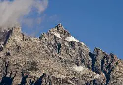
Mount Owen
Jackson, Wyoming
43.1 miles EHike near Jackson, Wyoming
Hike 13.8 mi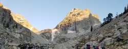
Middle Teton
Jackson Hole, Wyoming
43.1 miles EAt 12,804 ft above sea level, the Middle Teton is a challenging and beautiful hike from the trailhead all the way to the peak. The first part of the trail is dirt trails through the trees. That...
Backpack, Hike, Rock Climb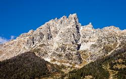
Teewinot Mountain
Jackson Hole, Wyoming
43.1 miles EBackpack and Hike near Jackson Hole, Wyoming
Backpack, Hike 3.6 mi
String Lake
Alta, Wyoming
44.2 miles EString Lake is a shallow lake that connects Leigh Lake and Jenny Lake at the base of Mount St. John and Rockchuck Peak. From the lakeshore, you can also take in beautiful views of Teewinot and Mt....
Canoe, Hike, Kayak, Swim 24.3 mi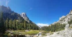
Cascade Canyon Trail
Jackson Hole, Wyoming
44.2 miles EThis hike starts the same as the Jenny Lake trail, then after you pass the boat dock, it takes off up Cascade Canyon just to the north of Teewinot, Mount Owen, and the Grand Teton along Cascade...
Backpack, Hike 0.1-7.3 mi
Leigh Lake
Alta, Wyoming
44.3 miles EEnjoy the grandeur of Grand Teton National Park just a little ways off the beaten path. Leigh Lake rests underneath the majestic Mount Moran. The waters of Leigh Lake flow almost directly into String...
Backpack, Canoe, Hike, Kayak
Pine Butte / The Caldera
St. Anthony, Idaho
44.3 miles NThis is about as close to an oasis as you can get in the deserts of Idaho. It's an old volcano in the middle of the sagebrush desert. As soon as you start down the path, you can feel the air...
Camp, Hike, Horseback


